Tel Yokneam
 Tel Yokneam
click on image to open in a new tab
Emmanuel Cohen - www.mgketer.org - Wikipedia - CC BY-SA 4.0
| Transliterated Name | Source | Name |
|---|---|---|
| Tel Yokneam | Hebrew | תֵּל יָקְנְעָם |
| Yoqne'am, Jokneam | Hebrew | |
| Tell Qamun | Arabic | تل قامون |
| Caymont, Cain Mons, Kaym Mons, Kaim Monte | Crusader Names | |
| Chateau d'El Kireh | French | |
| 'En-qn'mu | ||
| Kammona | ||
| Cimona | ||
| Qaymun | Arabic |
- Biblical Location Map
from BibleWalks.com
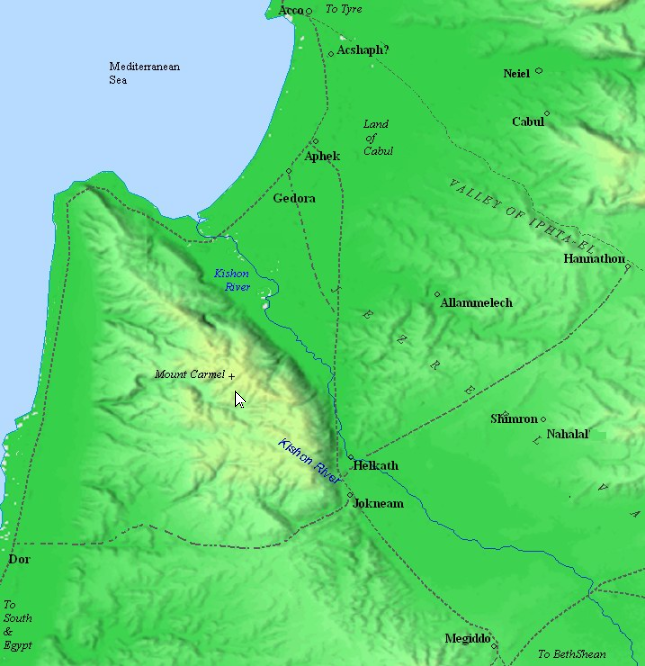 Biblical map – Canaanite and Israelite periods (based on Bible Mapper 3.0)
click on image to open in a new tab
Used with permission from BibleWalks.com
- Biblical Location Map
from BibleWalks.com
Biblical map – Canaanite and Israelite periods (based on Bible Mapper 3.0)
click on image to open in a new tab
Used with permission from BibleWalks.com
- Photo I.1 Aerial View
of Yoqne'am from Ben-Tor et al. (2005a)
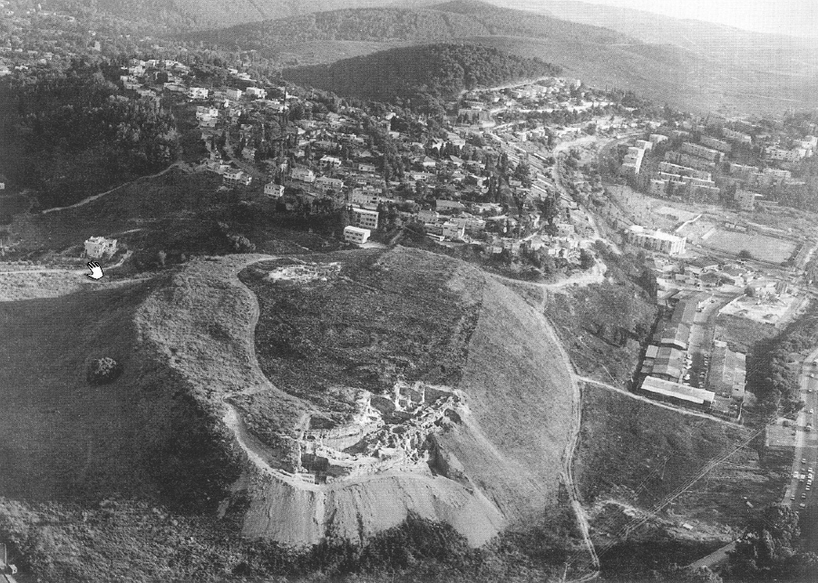 Photo I.1
Aerial View of Yoqne'am (view from the north)
click on image to explore in a new tab
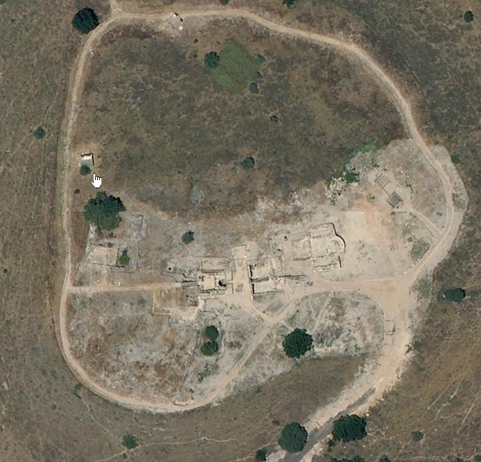
Ben-Tor et al. (2005a) - Annotated Google Satellite
View of Tel Yoknem from BibleWalks.com
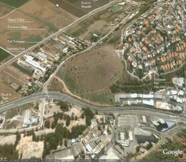 Annotated Google Satellite View of Tel Yokneam
click on image to explore in a new tab
Used with permission from BibleWalks.com - Tel Yokneam in Google Earth
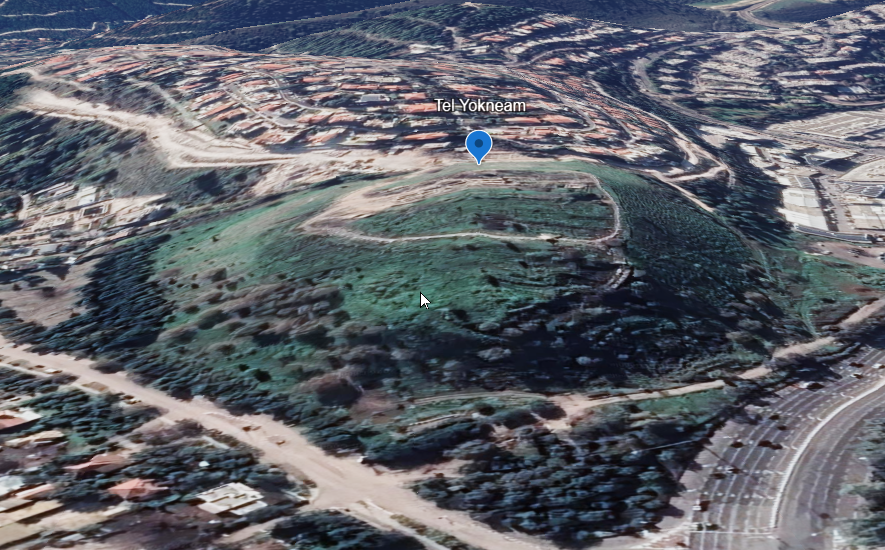 Tel Yokneam
click on image to explore this site on a new tab in Google Earth - Tel Yokneam on govmap.gov.il
 Tel Yokneam
click on image to explore this site on a new tab in govmap.gov.il
- Photo I.1 Aerial View
of Yoqne'am from Ben-Tor et al. (2005a)
Photo I.1
Aerial View of Yoqne'am (view from the north)
click on image to explore in a new tab
Ben-Tor et al. (2005a) - Annotated Google Satellite
View of Tel Yoknem from BibleWalks.com
Annotated Google Satellite View of Tel Yokneam
click on image to explore in a new tab
Used with permission from BibleWalks.com - Tel Yokneam in Google Earth
Tel Yokneam
click on image to explore this site on a new tab in Google Earth - Tel Yokneam on govmap.gov.il
Tel Yokneam
click on image to explore this site on a new tab in govmap.gov.il
- Biblical City Model of
Tel Yoknem from BibleWalks.com
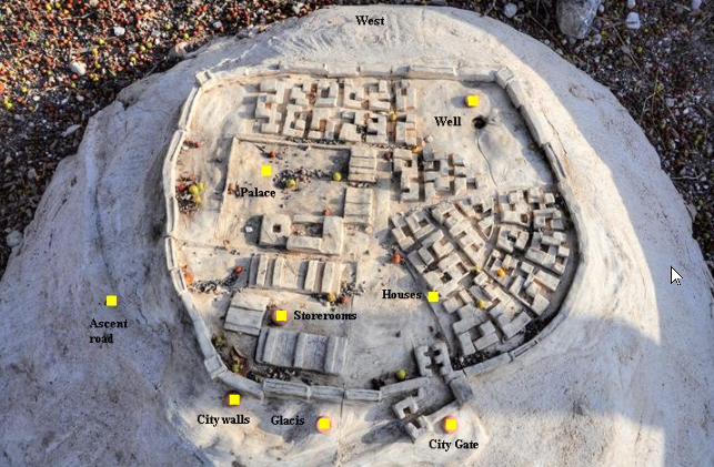 Biblical city model – courtesy of the archaeological park (located on the north west side)
click on image to explore in a new tab
Used with permission from BibleWalks.com - Map of the Mound and
Excavation Areas from Stern et al. (1993 v.3)
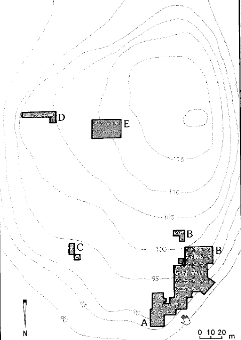 Map of the Mound and Excavation Areas
click on image to explore in a new tab
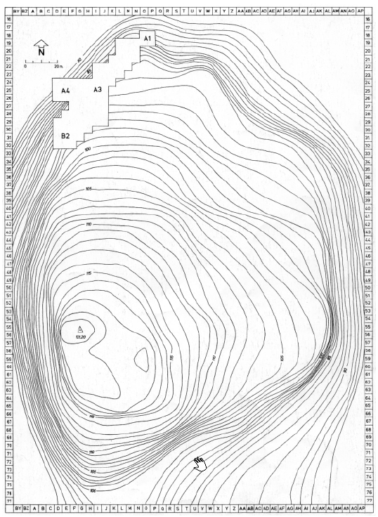
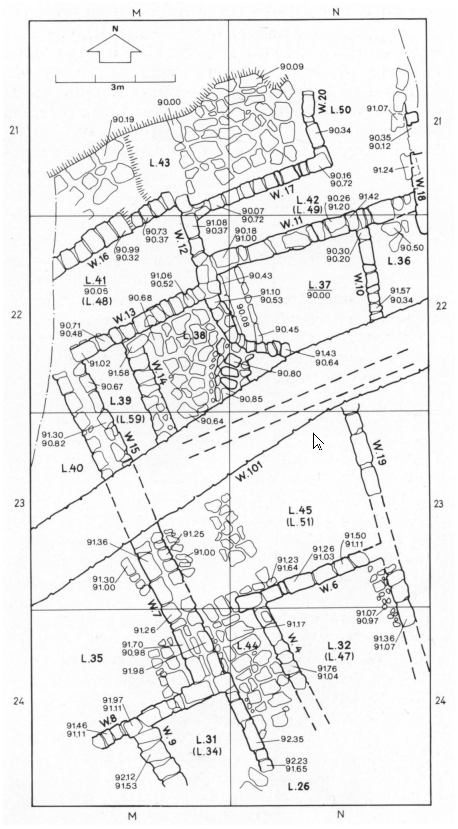
Stern et al. (1993 v.3) - Fig. 1 topography,
grid, and excavation areas from Ben-Tor et al. (1979)
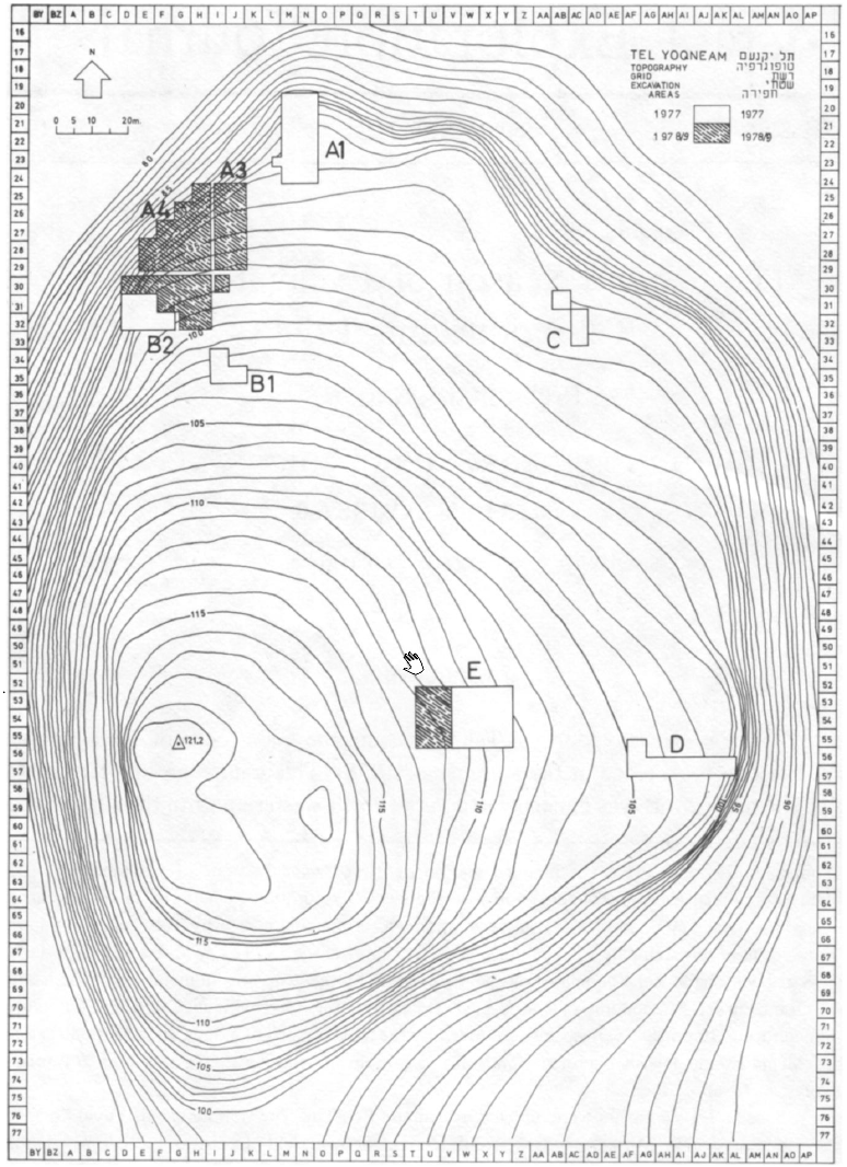 Fig. 1
Tel Yoqne'am: topography, grid, and excavation areas
click on image to explore in a new tab
Ben-Tor et al. (1979) - Plan I.1 topography,
grid, and excavation areas from Ben-Tor et al. (2005a)
 Plan I.1
Excavation areas at Tel Yoqne'am
click on image to explore in a new tab
Ben-Tor et al. (2005a)
- Biblical City Model of
Tel Yoknem from BibleWalks.com
Biblical city model – courtesy of the archaeological park (located on the north west side)
click on image to explore in a new tab
Used with permission from BibleWalks.com - Map of the Mound and
Excavation Areas from Stern et al. (1993 v.3)
Map of the Mound and Excavation Areas
click on image to explore in a new tab
Stern et al. (1993 v.3) - Fig. 1 topography,
grid, and excavation areas from Ben-Tor et al. (1979)
Fig. 1
Tel Yoqne'am: topography, grid, and excavation areas
click on image to explore in a new tab
Ben-Tor et al. (1979) - Plan I.1 topography,
grid, and excavation areas from Ben-Tor et al. (2005a)
Plan I.1
Excavation areas at Tel Yoqne'am
click on image to explore in a new tab
Ben-Tor et al. (2005a)
- Plan I.2 Iron Age Strata
at Tel Yoqne'am from Ben-Tor et al. (2005a)
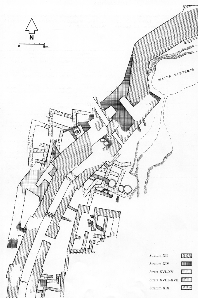 Plan I.2
Iron Age Strata at Tel Yoqne'am
click on image to explore in a new tab
Ben-Tor et al. (2005a) - Photo I.2 Aerial View of
Iron Age Strata (?) at Tel Yoqne'am from Ben-Tor et al. (2005a)
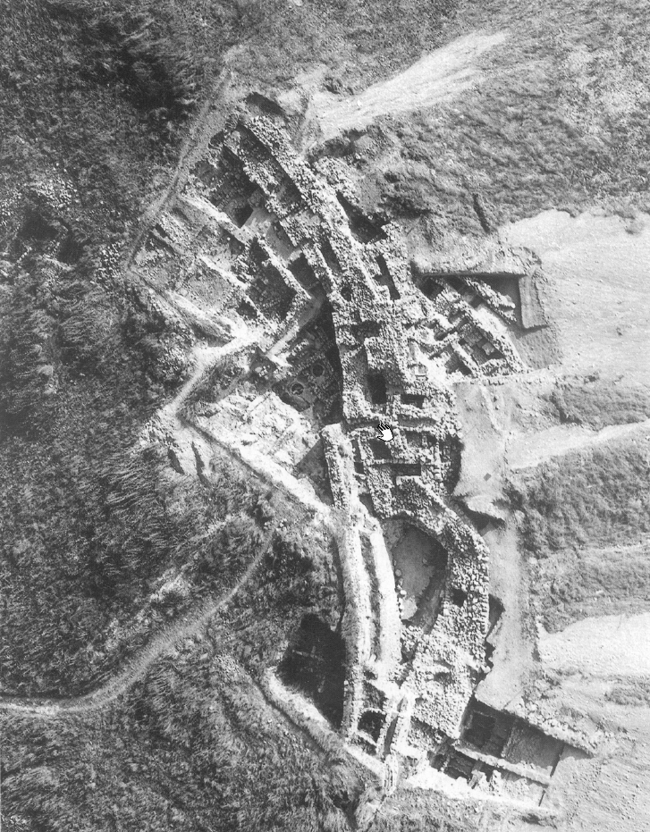 Photo I.2
Aerial View of Yoqne'am
click on image to explore in a new tab
Ben-Tor et al. (2005a)
- Plan I.2 Iron Age Strata
at Tel Yoqne'am from Ben-Tor et al. (2005a)
Plan I.2
Iron Age Strata at Tel Yoqne'am
click on image to explore in a new tab
Ben-Tor et al. (2005a) - Photo I.2 Aerial View of
Iron Age Strata (?) at Tel Yoqne'am from Ben-Tor et al. (2005a)
Photo I.2
Aerial View of Yoqne'am
click on image to explore in a new tab
Ben-Tor et al. (2005a) - Plan I.3 Area A1 Schematic
plan of Stratum XVIII-XVII from Ben-Tor et al. (2005a)
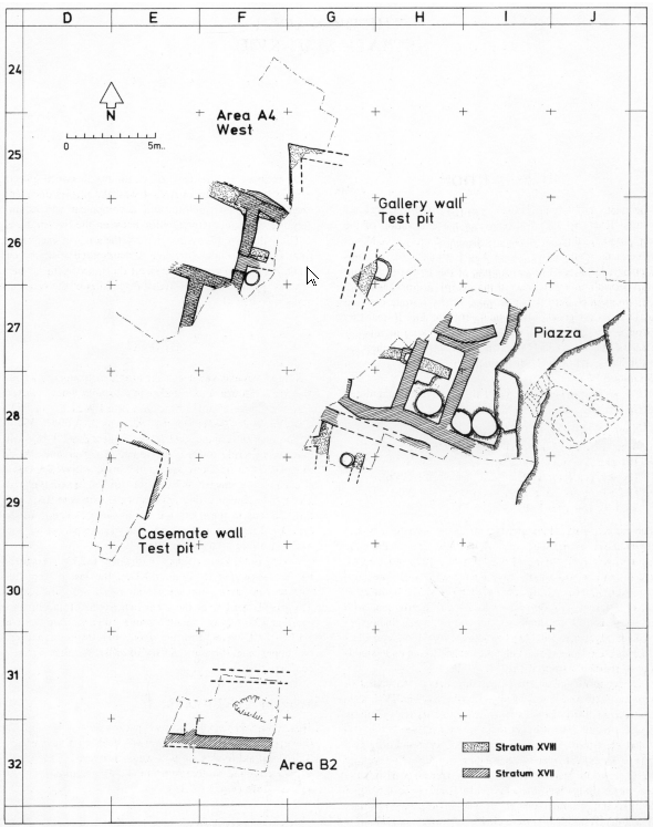 Plan I.3
Schematic plan of Stratum XVIII-XVII
click on image to explore in a new tab
Ben-Tor et al. (2005a) - Plan I.4 Area A1 Stratum XVIII
from Ben-Tor et al. (2005a)
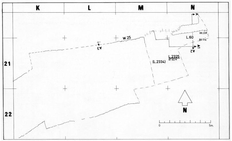 Plan I.4
Stratum XVIII, Area Al
click on image to explore in a new tab
Ben-Tor et al. (2005a) - Plan I.5 Area A1 Stratum XVII
from Ben-Tor et al. (2005a)
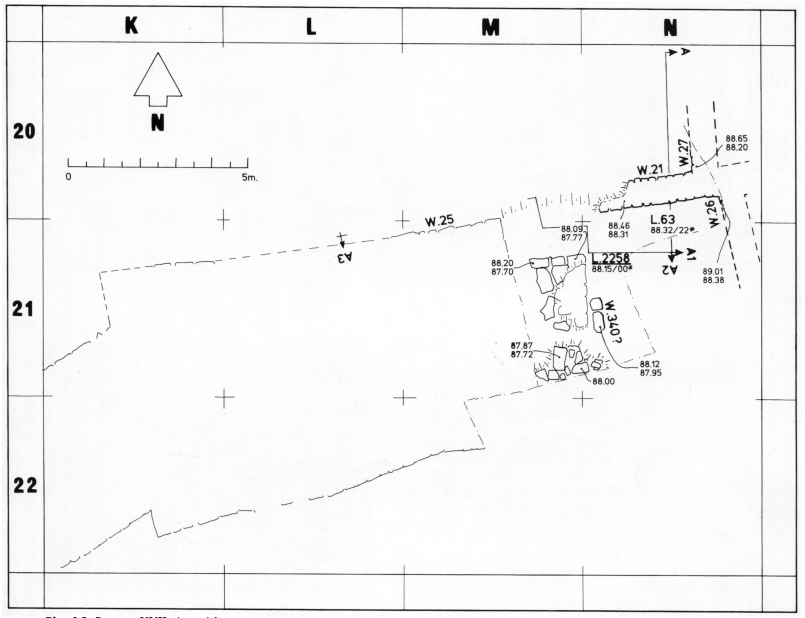 Plan I.5
Stratum XVII, Area Al
click on image to explore in a new tab
Ben-Tor et al. (2005a) - Plan I.5 Sections showing
relation between remains of Late Bronze Age (Stratum XIX) and Iron Age I (Stratum XVIII) from Ben-Tor et al. (2005a)
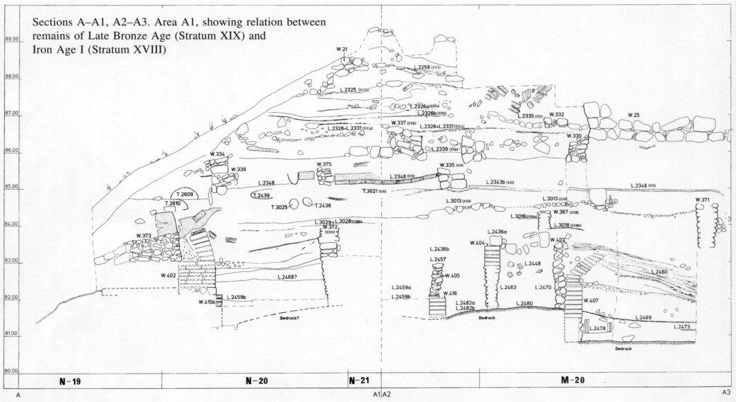 Sections A-A1, A2-A3, Area A1 showing relation between remains of Late Bronze Age (Stratum XIX)
and Iron Age I (Stratum XVIII)
Sections A-A1, A2-A3, Area A1 showing relation between remains of Late Bronze Age (Stratum XIX)
and Iron Age I (Stratum XVIII)
click on image to explore in a new tab
Ben-Tor et al. (2005a)
- Plan I.2 Iron Age Strata
at Tel Yoqne'am from Ben-Tor et al. (2005a)
Plan I.2
Iron Age Strata at Tel Yoqne'am
click on image to explore in a new tab
Ben-Tor et al. (2005a) - Photo I.2 Aerial View of
Iron Age Strata (?) at Tel Yoqne'am from Ben-Tor et al. (2005a)
Photo I.2
Aerial View of Yoqne'am
click on image to explore in a new tab
Ben-Tor et al. (2005a) - Plan I.3 Area A1 Schematic
plan of Stratum XVIII-XVII from Ben-Tor et al. (2005a)
Plan I.3
Schematic plan of Stratum XVIII-XVII
click on image to explore in a new tab
Ben-Tor et al. (2005a) - Plan I.4 Area A1 Stratum XVIII
from Ben-Tor et al. (2005a)
Plan I.4
Stratum XVIII, Area Al
click on image to explore in a new tab
Ben-Tor et al. (2005a) - Plan I.5 Area A1 Stratum XVII
from Ben-Tor et al. (2005a)
Plan I.5
Stratum XVII, Area Al
click on image to explore in a new tab
Ben-Tor et al. (2005a) - Plan I.5 Sections showing
relation between remains of Late Bronze Age (Stratum XIX) and Iron Age I (Stratum XVIII) from Ben-Tor et al. (2005a)
Sections A-A1, A2-A3, Area A1 showing relation between remains of Late Bronze Age (Stratum XIX)
and Iron Age I (Stratum XVIII)
click on image to explore in a new tab
Ben-Tor et al. (2005a)
- Plan III.5 Area A4, Stratum XIXa
from Ben-Tor et al. (2005b)
 Plan III.5
Area A4, Stratum XIXa
click on image to explore in a new tab
Ben-Tor et al. (2005b)
- Plan III.5 Area A4, Stratum XIXa
from Ben-Tor et al. (2005b)
Plan III.5
Area A4, Stratum XIXa
click on image to explore in a new tab
Ben-Tor et al. (2005b)
- Plan IV.4 Area A, stratum IVa,
northernmost section from Ben-Tor et al. (1996)
 Plan IV.4
Area A, stratum IVa, northernmost section.
click on image to explore in a new tab
Ben-Tor et al. (1996)
- Plan IV.4 Area A, stratum IVa,
northernmost section from Ben-Tor et al. (1996)
Plan IV.4
Area A, stratum IVa, northernmost section.
click on image to explore in a new tab
Ben-Tor et al. (1996)
- Photo I.11 Crushed pottery
from Ben-Tor et al. (2005a)
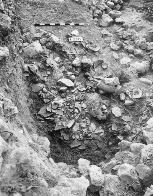 Photo I.11
Pottery in situ inside Structure 2511
click on image to explore in a new tab
Ben-Tor et al. (2005a) - Photo I.12 Crushed pottery
(closeup) from Ben-Tor et al. (2005a)
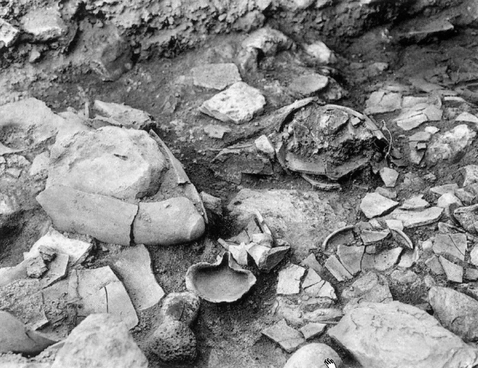 Photo I.12
Pottery in situ inside Structure 2511 (detial)
click on image to explore in a new tab
Ben-Tor et al. (2005a) - Photo I.23 Floor with some
broken pots in locus L.3032 from Ben-Tor et al. (2005a)
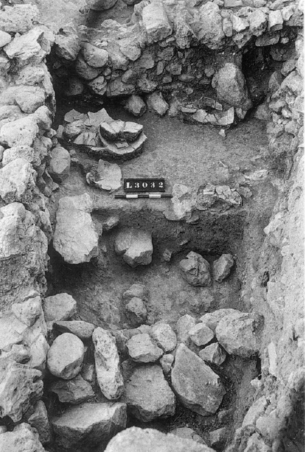 Photo I.23
L.3032 (Stratum XVII; view from north); note floor with pottery in situ ; in foreground, section under floor reveals W.318 (Straum XVIII)
click on image to explore in a new tab
Ben-Tor et al. (2005a) - Photo I.24 More broken pottery
in locus L.3032 from Ben-Tor et al. (2005a)
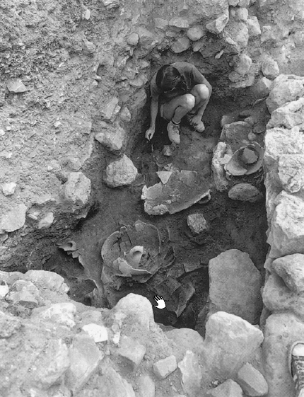 Photo I.24
L.3032 with pottery vessels in situ (view to north)
click on image to explore in a new tab
Ben-Tor et al. (2005a) - Photo I.26 Broken pottery
in locus L.3036 from Ben-Tor et al. (2005a)
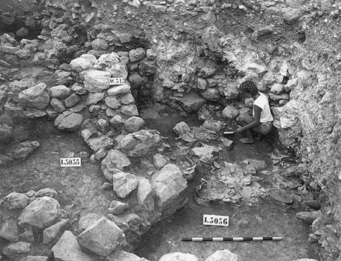 Photo I.26
L.3036 with pottery vessels in situ (view to west)
click on image to explore in a new tab
Ben-Tor et al. (2005a) - Photo I.29 Broken pottery
in locus L.3036 from Ben-Tor et al. (2005a)
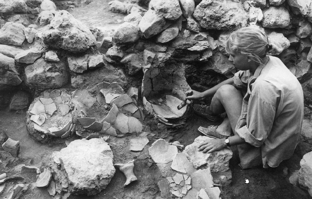 Photo I.29
L.3036 with pottery vessels in situ; three storage jars leaning against W.313 (view to south)
click on image to explore in a new tab
Ben-Tor et al. (2005a) - Photo III.20 Stratum XIXa
destruction layer from Ben-Tor et al. (2005b)
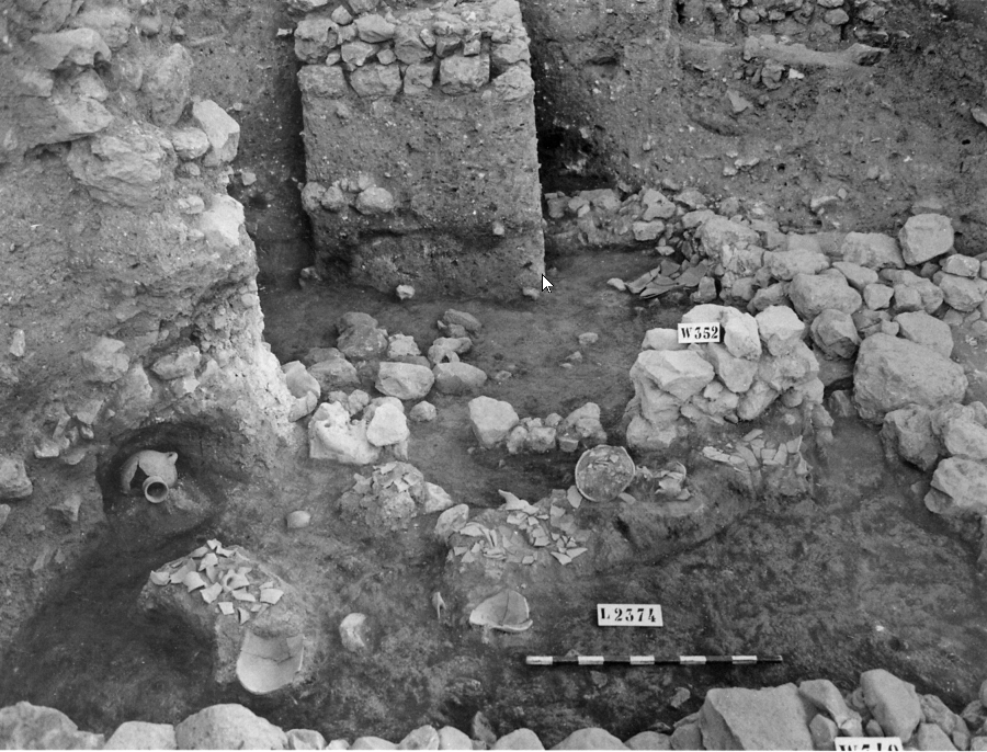 Photo III.20
The destruction layer of the final Late Bronze Age city, looking south. Broken vessels and an ash layer are clearly visible. Note the accumulation of debris over remains of Stratum XIXa and below the foundations of Iron Age I walls (Stratum XVIII).
click on image to explore in a new tab
Ben-Tor et al. (2005b)
- Photo I.11 Crushed pottery
from Ben-Tor et al. (2005a)
Photo I.11
Pottery in situ inside Structure 2511
click on image to explore in a new tab
Ben-Tor et al. (2005a) - Photo I.12 Crushed pottery
(closeup) from Ben-Tor et al. (2005a)
Photo I.12
Pottery in situ inside Structure 2511 (detial)
click on image to explore in a new tab
Ben-Tor et al. (2005a) - Photo I.23 Floor with some
broken pots in locus L.3032 from Ben-Tor et al. (2005a)
Photo I.23
L.3032 (Stratum XVII; view from north); note floor with pottery in situ ; in foreground, section under floor reveals W.318 (Straum XVIII)
click on image to explore in a new tab
Ben-Tor et al. (2005a) - Photo I.24 More broken pottery
in locus L.3032 from Ben-Tor et al. (2005a)
Photo I.24
L.3032 with pottery vessels in situ (view to north)
click on image to explore in a new tab
Ben-Tor et al. (2005a) - Photo I.26 Broken pottery
in locus L.3036 from Ben-Tor et al. (2005a)
Photo I.26
L.3036 with pottery vessels in situ (view to west)
click on image to explore in a new tab
Ben-Tor et al. (2005a) - Photo I.29 Broken pottery
in locus L.3036 from Ben-Tor et al. (2005a)
Photo I.29
L.3036 with pottery vessels in situ; three storage jars leaning against W.313 (view to south)
click on image to explore in a new tab
Ben-Tor et al. (2005a) - Photo III.20 Stratum XIXa
destruction layer from Ben-Tor et al. (2005b)
Photo III.20
The destruction layer of the final Late Bronze Age city, looking south. Broken vessels and an ash layer are clearly visible. Note the accumulation of debris over remains of Stratum XIXa and below the foundations of Iron Age I walls (Stratum XVIII).
click on image to explore in a new tab
Ben-Tor et al. (2005b)
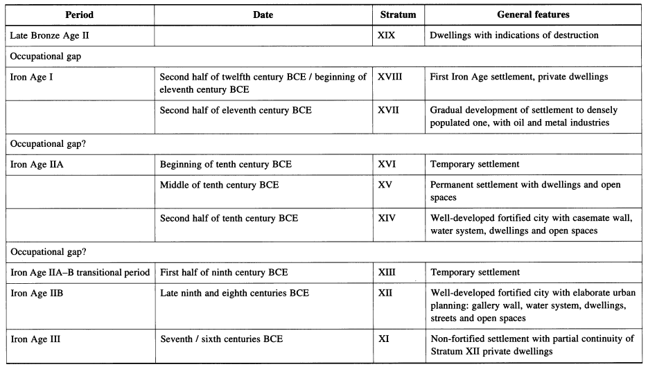 Table I.1
The stratigraphic sequence
click on image to open in a new tab
Ben-Tor et al. (2005a)
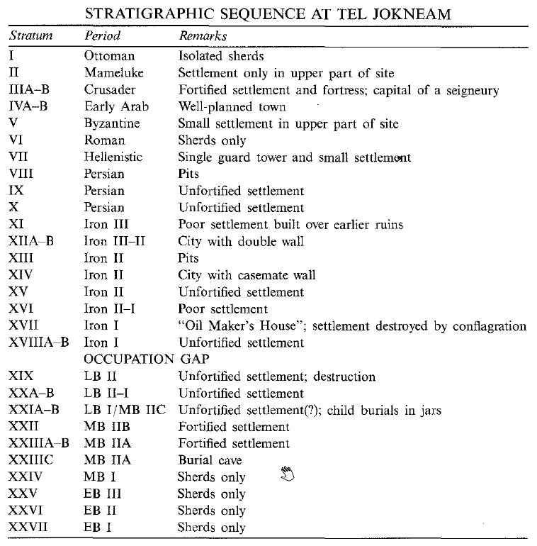 Stratigraphic Sequence at Tel JokneamTel Yokneam
click on image to open in a new tab
Stern et al. (1993 v.3)
| Effect | Location | Image(s) | Description(s) |
|---|---|---|---|
|
Area A4
Fig. 1
Tel Yoqne'am: topography, grid, and excavation areas click on image to explore in a new tab Ben-Tor et al. (1979)
Plan III.5
Area A4, Stratum XIXa click on image to explore in a new tab Ben-Tor et al. (2005b) |
Photo III.20
The destruction layer of the final Late Bronze Age city, looking south. Broken vessels and an ash layer are clearly visible. Note the accumulation of debris over remains of Stratum XIXa and below the foundations of Iron Age I walls (Stratum XVIII). click on image to explore in a new tab Ben-Tor et al. (2005b) |
|
| Effect | Location | Image(s) | Description(s) |
|---|---|---|---|
|
Area A1
Fig. 1
Tel Yoqne'am: topography, grid, and excavation areas click on image to explore in a new tab Ben-Tor et al. (1979)
Plan I.5
Stratum XVII, Area Al click on image to explore in a new tab Ben-Tor et al. (2005a)
Plan I.2
Iron Age Strata at Tel Yoqne'am click on image to explore in a new tab Ben-Tor et al. (2005a)
Photo I.2
Aerial View of Yoqne'am click on image to explore in a new tab Ben-Tor et al. (2005a) |
Sections A-A1, A2-A3, Area A1 showing relation between remains of Late Bronze Age (Stratum XIX)
and Iron Age I (Stratum XVIII)
click on image to explore in a new tab Ben-Tor et al. (2005a) |
|
| Effect | Location | Image(s) | Description(s) |
|---|---|---|---|
|
Area A
Fig. 1
Tel Yoqne'am: topography, grid, and excavation areas click on image to explore in a new tab Ben-Tor et al. (1979)
Plan IV.4
Area A, stratum IVa, northernmost section. click on image to explore in a new tab Ben-Tor et al. (1996) |
|
- Earthquake Archeological Effects chart
of Rodríguez-Pascua et al (2013: 221-224)
 Earthquake Archeological Effects (EAE)
Rodríguez-Pascua et al (2013: 221-224)
| Effect | Location | Image(s) | Description(s) | Intensity |
|---|---|---|---|---|
|
Area A4
Fig. 1
Tel Yoqne'am: topography, grid, and excavation areas click on image to explore in a new tab Ben-Tor et al. (1979)
Plan III.5
Area A4, Stratum XIXa click on image to explore in a new tab Ben-Tor et al. (2005b) |
Photo III.20
The destruction layer of the final Late Bronze Age city, looking south. Broken vessels and an ash layer are clearly visible. Note the accumulation of debris over remains of Stratum XIXa and below the foundations of Iron Age I walls (Stratum XVIII). click on image to explore in a new tab Ben-Tor et al. (2005b) |
|
|
- Earthquake Archeological Effects chart
of Rodríguez-Pascua et al (2013: 221-224)
Earthquake Archeological Effects (EAE)
Rodríguez-Pascua et al (2013: 221-224)
| Effect | Location | Image(s) | Description(s) | Intensity |
|---|---|---|---|---|
|
Area A1
Fig. 1
Tel Yoqne'am: topography, grid, and excavation areas click on image to explore in a new tab Ben-Tor et al. (1979)
Plan I.5
Stratum XVII, Area Al click on image to explore in a new tab Ben-Tor et al. (2005a)
Plan I.2
Iron Age Strata at Tel Yoqne'am click on image to explore in a new tab Ben-Tor et al. (2005a)
Photo I.2
Aerial View of Yoqne'am click on image to explore in a new tab Ben-Tor et al. (2005a) |
Sections A-A1, A2-A3, Area A1 showing relation between remains of Late Bronze Age (Stratum XIX)
and Iron Age I (Stratum XVIII)
click on image to explore in a new tab Ben-Tor et al. (2005a) |
|
|
- Earthquake Archeological Effects chart
of Rodríguez-Pascua et al (2013: 221-224)
Earthquake Archeological Effects (EAE)
Rodríguez-Pascua et al (2013: 221-224)
| Effect | Location | Image(s) | Description(s) | Intensity |
|---|---|---|---|---|
|
Area A
Fig. 1
Tel Yoqne'am: topography, grid, and excavation areas click on image to explore in a new tab Ben-Tor et al. (1979)
Plan IV.4
Area A, stratum IVa, northernmost section. click on image to explore in a new tab Ben-Tor et al. (1996) |
|
|