Khirbet Iskander
 Khirbet Iskander
Click on image to explore in Google Earth
| Transliterated Name | Source | Name |
|---|---|---|
| Khirbet Iskander | Arabic | خربة اسكندر |
- Fig. 1 Location Map
from Richard et al. (2018)
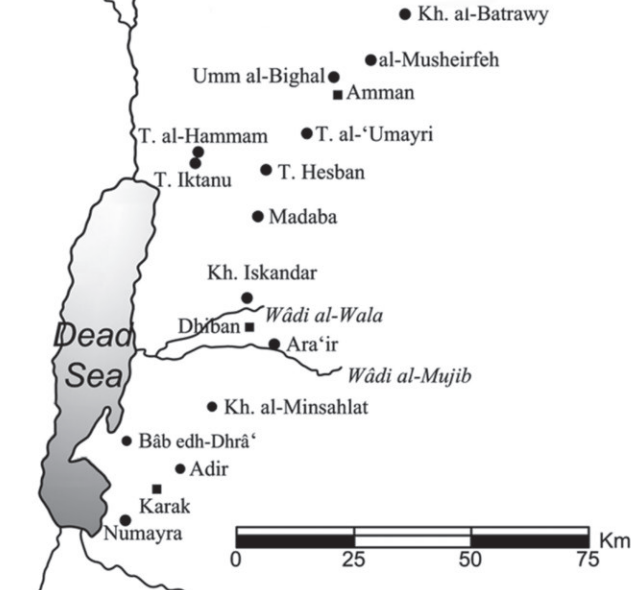 Fig. 1
Map showing the location of Khirbat Iskandar
Richard et al. (2018)
- Fig. 1 Location Map
from Richard et al. (2018)
Fig. 1
Map showing the location of Khirbat Iskandar
Richard et al. (2018)
- Khirbet Iskander in Google Earth
Khirbet Iskander
click on image to explore this site on a new tab in Google Earth
- Fig. 2 Contour map of
the mound showing the three excavated areas, A, B, and C from Richard and Boraas (1998)
 Fig. 1
Contour map of the mound showing the three excavated areas, A, B, and C
Richard and Boraas (1998) - Fig. 2 Excavation Areas
from Richard et al. (2018)
 Fig. 2
Plan showing excavation areas at Khirbat Iskandar
Richard et al. (2018)
- Fig. 2 Contour map of
the mound showing the three excavated areas, A, B, and C from Richard and Boraas (1998)
Fig. 1
Contour map of the mound showing the three excavated areas, A, B, and C
Richard and Boraas (1998) - Fig. 2 Excavation Areas
from Richard et al. (2018)
Fig. 2
Plan showing excavation areas at Khirbat Iskandar
Richard et al. (2018)
- Fig. 3 Plan of Area C
from from Richard et al. (2020)
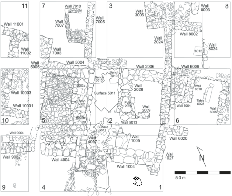 Figure 3
Plan of Area C
Click on image to open the image in a new tab
Richard et al. (2020)
- Fig. 3 Plan of Area C
from from Richard et al. (2020)
Figure 3
Plan of Area C
Click on image to open the image in a new tab
Richard et al. (2020)
- Fig. 5 Wall Collapse
from from Richard et al. (2020)
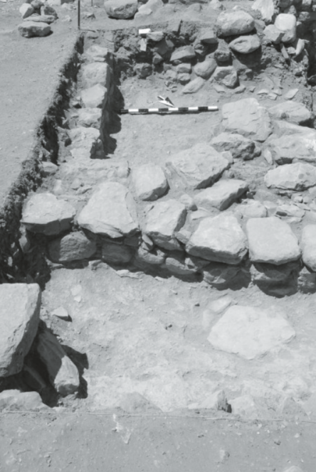 Figure 5
Square C08: the Phase 3B structure at top, the Phase 3A pillar base at bottom (photo: G. Kochheiser)
Click on image to open the image in a new tab
Richard et al. (2020) - Square C06 photo by JW
 Square C06 looking N
Click on image to open in a new tab
Photo by Jefferson Williams - 30 Jan. 2026
- Fig. 5 Wall Collapse
from from Richard et al. (2020)
Figure 5
Square C08: the Phase 3B structure at top, the Phase 3A pillar base at bottom (photo: G. Kochheiser)
Click on image to open the image in a new tab
Richard et al. (2020) - Square C06 photo by JW
Square C06 looking N
Click on image to open in a new tab
Photo by Jefferson Williams - 30 Jan. 2026
| Effect | Location | Image | Description |
|---|---|---|---|
|
Square C06 and "in the north"
Fig. 1 Contour map of the mound showing the three excavated areas, A, B, and C Richard and Boraas (1998)
Fig. 2Plan showing excavation areas at Khirbat Iskandar Richard et al. (2018)
Figure 3Plan of Area C Click on image to open the image in a new tab Richard et al. (2020) |
Square C06 looking N
Click on image to open in a new tab Photo by Jefferson Williams - 30 Jan. 2026 |
|
- Earthquake Archeological Effects chart
of Rodríguez-Pascua et al (2013: 221-224)
 Earthquake Archeological Effects (EAE)
Rodríguez-Pascua et al (2013: 221-224)
| Effect | Location | Image | Description | Intensity |
|---|---|---|---|---|
|
Square C06 and "in the north"
Fig. 1 Contour map of the mound showing the three excavated areas, A, B, and C Richard and Boraas (1998)
Fig. 2Plan showing excavation areas at Khirbat Iskandar Richard et al. (2018)
Figure 3Plan of Area C Click on image to open the image in a new tab Richard et al. (2020) |
Square C06 looking N
Click on image to open in a new tab Photo by Jefferson Williams - 30 Jan. 2026 |
|
|