Tell el-Far’ah North
 Tell el-Far’ah North
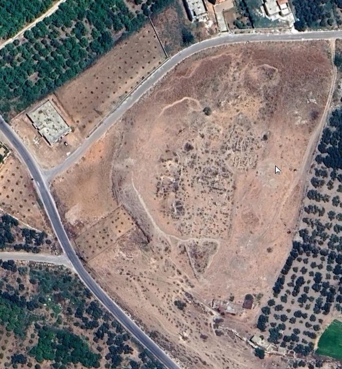
click on image to explore this site on a new tab in Google Earth
| Transliterated Name | Source | Name |
|---|---|---|
| Tell el-Far’ah | Arabic | تلّ الفارعة |
| Tirzah | Hebrew | תִּרְצָה |
Tell el-Fareah was explored by Roland de Vaux between 1946 and 1960. De Vaux excavated four fields, three of them (Chantiers II, III and IV) on the western side of the mound and one (Chantier I) in the north. Five sections were dug on the northeastern slope, between Chantier I and Ein el-Fareah. Admittedly, much of the site — especially its heart and eastern sector — has not been investigated.4 Still, the information from Tell el-Fareah is significant: the mound spreads across ca. five hectares,5 of which 0.5 hectare was dug in Chantier II alone.6 This means that the total area excavated in the three western fields seems to make up ca. 15% of the mound7 — more than the relative proportion of the excavated fields in most biblical mounds.
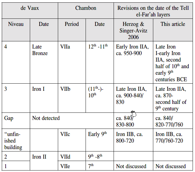 Table 1
The stratigraphy of Tell el-Far'ah – from de Vaux to the current article
click on image to open in a new tab
Finkelstein (2012)
De Vaux published a series of preliminary reports on the results of his dig in Revue biblique.8 He described continuous occupation from the Late Bronze II through the Iron I to the Iron II, with Niveau 4 standing for the Late Bronze Age and Niveaux 3–1 covering the Iron Age.9 The final report of the Late Bronze finds has not been published to date. The final report of the Iron Age finds was published by Chambon10 many years after the conclusion of the dig. Chambon introduced a new stratigraphic system, with Period VI standing for the Late Bronze Age and Period VII with five phases standing for the Iron Age.11 A new, short evaluation of the stratigraphy and chronology of Tell el-Fareah in the Iron Age has recently been presented by Herzog and Singer-Avitz.12 ...
- Fig. 4 - Location Map from
Tappy (2014)
 Figure 4.18
Map of Israel
(Ron E. Tappy)
Tappy (2014)
- Fig. 4 - Location Map from
Tappy (2014)
Figure 4.18
Map of Israel
(Ron E. Tappy)
Tappy (2014)
- Tell el-Far’ah North in Google Earth
Tell el-Far’ah North
click on image to explore this site on a new tab in Google Earth - Tell el-Far’ah North on govmap.gov.il
 Tell el-Far’ah North
click on image to explore this site on a new tab in govmap.gov.il
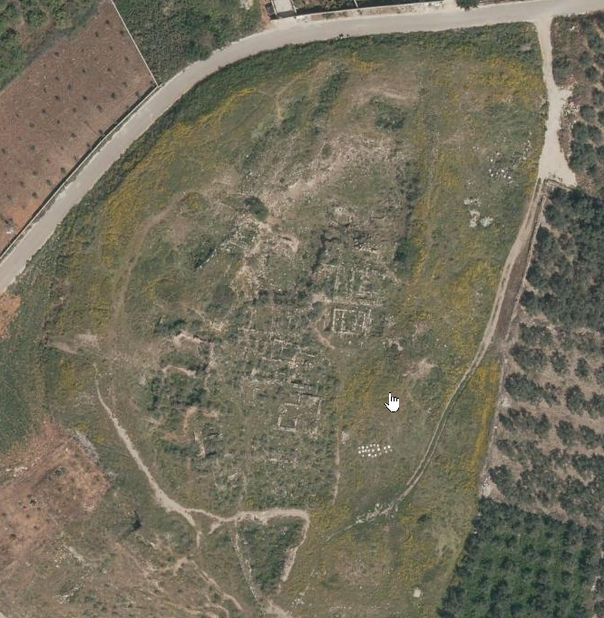
- Plan of the mound and excavation
areas from Stern et al. (1993 v.2)
 Tell el-Far’ah North: plan of the mound and excavation areas
click on image to open in a new tab
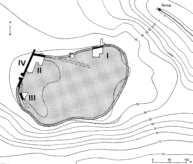
Stern et al. (1993 v.2) - Fig. 2 Period VIIa Site Plan
from Finkelstein (2012)
Fig. 2
Plan of Tell el-Far{ah, emphasizing the restricted size of the Period VIIa settlement
(based on Chambon 1984: Pl. 4)
click on image to open in a new tab
Finkelstein (2012)
- Plan of the mound and excavation
areas from Stern et al. (1993 v.2)
Tell el-Far’ah North: plan of the mound and excavation areas
click on image to open in a new tab
Stern et al. (1993 v.2) - Fig. 2 Period VIIa Site Plan
from Finkelstein (2012)
Fig. 2
Plan of Tell el-Far{ah, emphasizing the restricted size of the Period VIIa settlement
(based on Chambon 1984: Pl. 4)
click on image to open in a new tab
Finkelstein (2012)
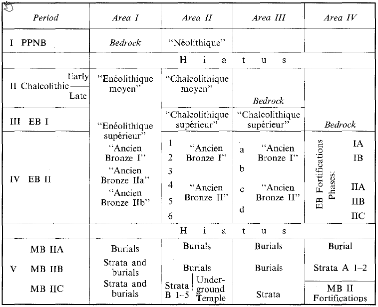 Stratigraphy at Tell el-Far'ah North from Neolithic to Middle Bronze in Areas I, II, III, and IV
click on image to open in a new tab
Stern et al. (1993 v.2)
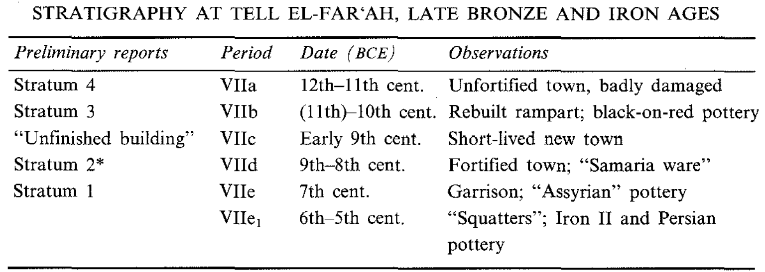 Stratigraphy at Tell el-Far'ah North, Late Bronze and Iron Ages
click on image to open in a new tab
Stern et al. (1993 v.2)
- from Finkelstein (2012)
- "De Vaux published a series of preliminary reports on the results of his dig in Revue biblique. He described continuous occupation from the Late Bronze II through the Iron I to the Iron II, with Niveau 4 standing for the Late Bronze Age and Niveaux 3–1 covering the Iron Age. The final report of the Late Bronze finds has not been published to date. The final report of the Iron Age finds was published by Chambon many years after the conclusion of the dig. Chambon introduced a new stratigraphic system, with Period VI standing for the Late Bronze Age and Period VII with five phases standing for the Iron Age. A new, short evaluation of the stratigraphy and chronology of Tell el-Fareah in the Iron Age has recently been presented by Herzog and Singer-Avitz." Finkelstein (2012:334-335)
Table 1
The stratigraphy of Tell el-Far'ah – from de Vaux to the current article
click on image to open in a new tab
Finkelstein (2012)
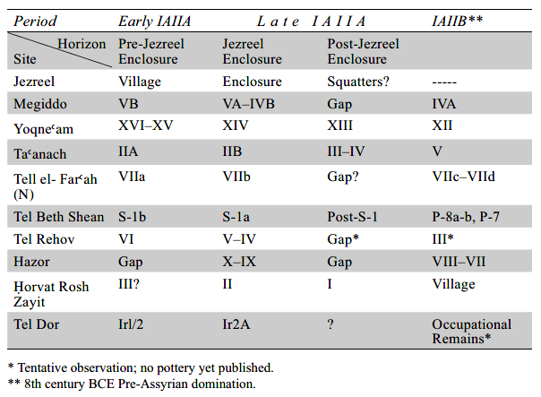 Table 1
Stratigraphic Sequence And Settlement Pattern Of Sites In Northern Israel
click on image to open in a new tab
Herzog and Singer-Avitz (2006)