Tel Yarmuth
 Tel Yarmuth
click on image to open in a new tab
Used with permission from BibleWalks.com
| Transliterated Name | Source | Name |
|---|---|---|
| Tel Yarmuth, Tel Yarmouth, Tel Yarmut | Hebrew | |
| Khirbet Yarmuk | Arabic | |
| Jarmuth | Hebrew | יַרְמוּת |
| Jermokes | Greek | Ιερμοχως |
| Jermous | Greek | Ιερμους |
- Location Map from
de Miroschedji (1999)
 Location Map
click on image to open in a new tab
de Miroschedji (1999)
- Location Map from
de Miroschedji (1999)
Location Map
click on image to open in a new tab
de Miroschedji (1999)
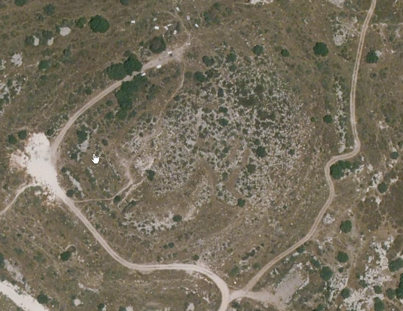
- Annotated Google Satellite
View of Tel Yarmuth from BibleWalks.com
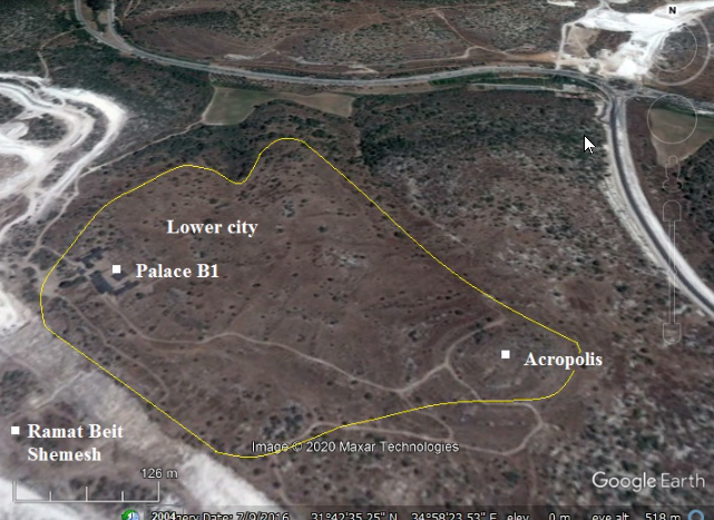 Annotated Google Satellite View of Tel Yarmuth
click on image to explore in a new tab
Used with permission from BibleWalks.com - Tel Yarmuth in Google Earth
 Tel Yarmuth
click on image to explore this site on a new tab in Google Earth - Tel Yarmuth on govmap.gov.il
 Tel Yarmuth
click on image to explore this site on a new tab in govmap.gov.il
- Annotated Google Satellite
View of Tel Yarmuth from BibleWalks.com
Annotated Google Satellite View of Tel Yarmuth
click on image to explore in a new tab
Used with permission from BibleWalks.com - Tel Yarmuth in Google Earth
Tel Yarmuth
click on image to explore this site on a new tab in Google Earth - Tel Yarmuth on govmap.gov.il
Tel Yarmuth
click on image to explore this site on a new tab in govmap.gov.il
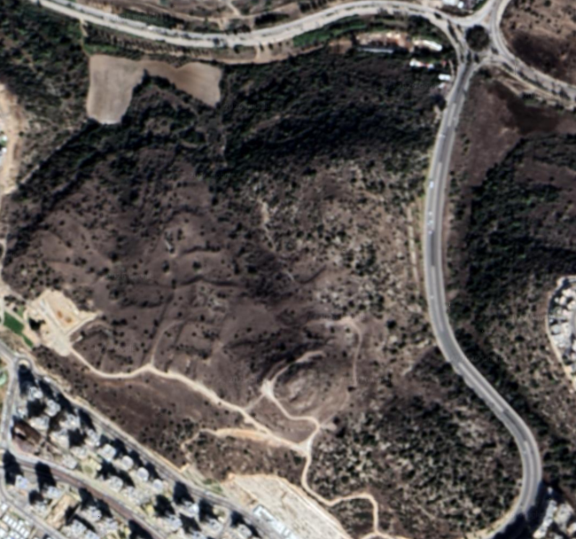
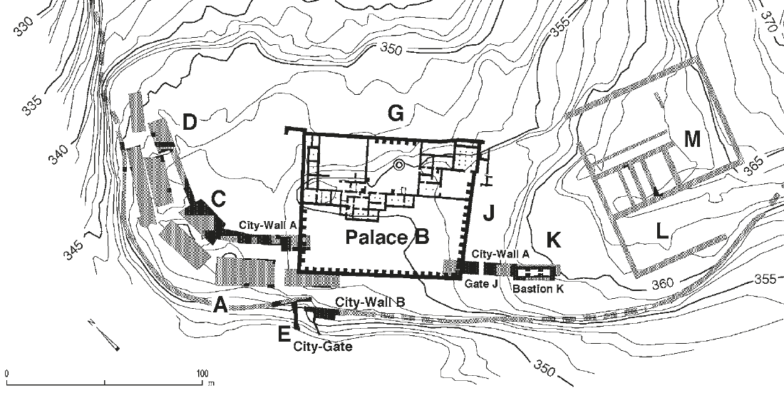
- Topographic plan of Tel Jarmuth
showing excavated areas and remains of fortifications from Stern et al. (2008)
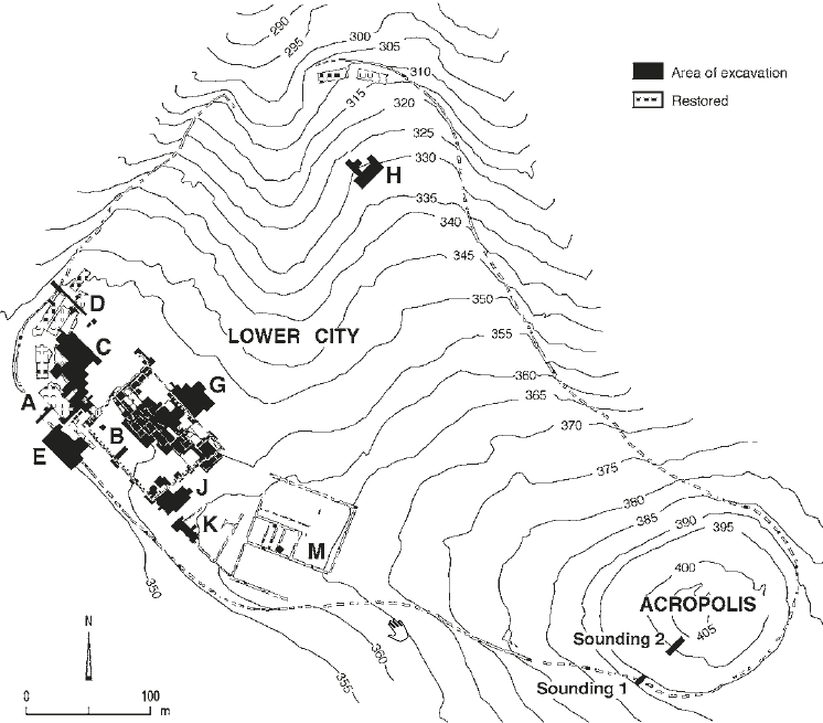 Tel Jarmuth: topographical plan, showing excavation areas and remains of fortifications excavated or traced on the surface
click on image to open in a new tab
Stern et al. (2008) - Topographic plan of Tel Jarmuth
showing excavated areas and remains of fortifications from Stern et al. (1993 v.2)
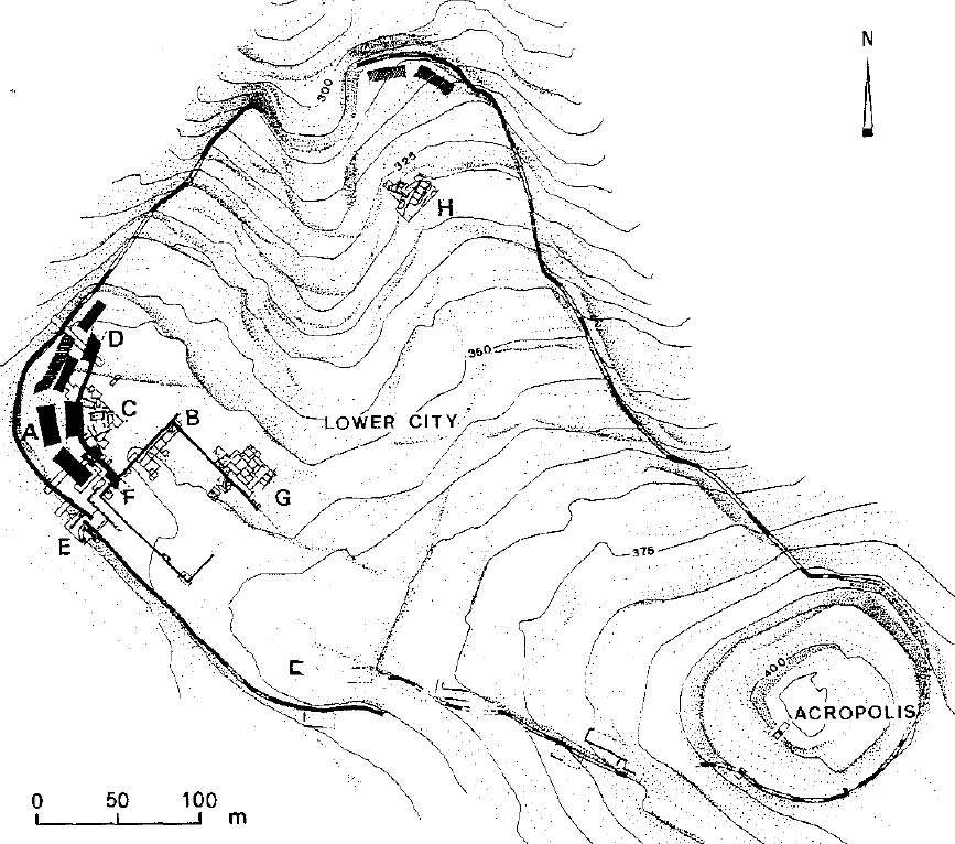 Topographic plan of Tel Jarmuth, showing excavated areas and remains of fortifications traced on the surface
click on image to open in a new tab
Stern et al. (1993 v.2)
- Topographic plan of Tel Jarmuth
showing excavated areas and remains of fortifications from Stern et al. (2008)
Tel Jarmuth: topographical plan, showing excavation areas and remains of fortifications excavated or traced on the surface
click on image to open in a new tab
Stern et al. (2008) - Topographic plan of Tel Jarmuth
showing excavated areas and remains of fortifications from Stern et al. (1993 v.2)
Topographic plan of Tel Jarmuth, showing excavated areas and remains of fortifications traced on the surface
click on image to open in a new tab
Stern et al. (1993 v.2)
- Plan of palace B1,
areas G (stratum G-2) and J (stratum J-1) from Stern et al. (2008)
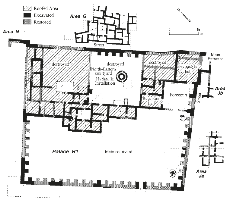 Plan of palace B1, areas G (stratum G-2) and J (stratum J-1).
click on image to open in a new tab
Stern et al. (2008) - Plan of the southwestern
corner of the lower city from Stern et al. (2008)
 Plan of the southwestern corner of the lower city.
click on image to open in a new tab
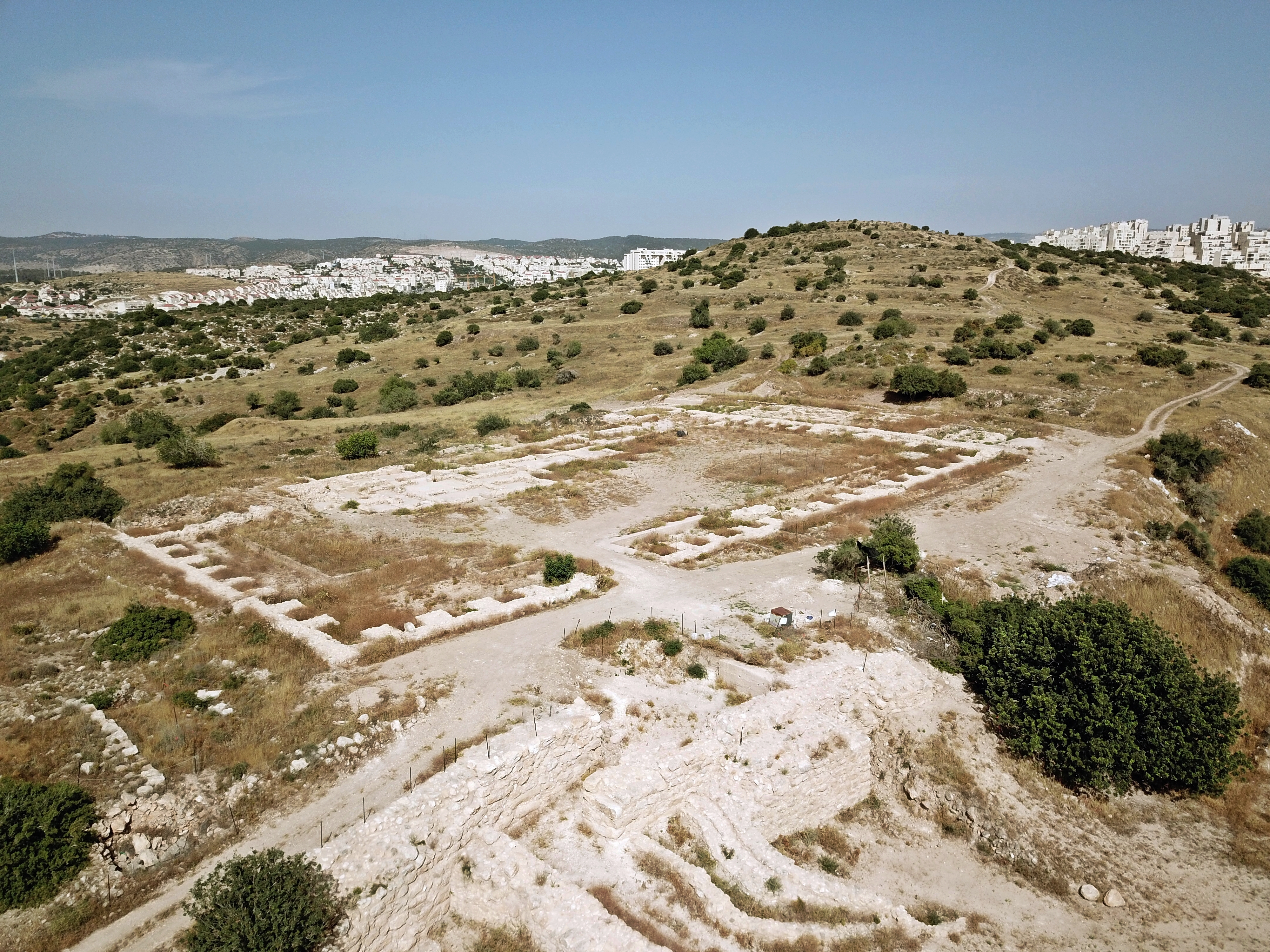
Stern et al. (2008) - Aerial view of palace B1
from Stern et al. (2008)
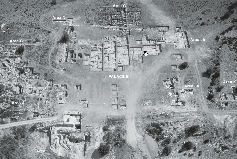 Aerial view of palace B1, looking northeast (1999).
click on image to open in a new tab
Stern et al. (2008) - Aerial view of areas Bd,
Ja, and K, showing the excavated remains of the fortifications from Stern et al. (2008)
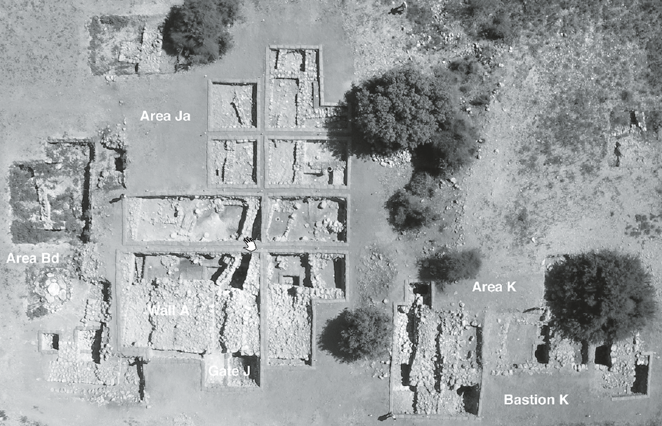 Aerial view of areas Bd, Ja, and K, showing the excavated remains of the fortifications (wall A, gate J, and bastion K), looking northeast.
click on image to open in a new tab
Stern et al. (2008)
- Plan of palace B1,
areas G (stratum G-2) and J (stratum J-1) from Stern et al. (2008)
Plan of palace B1, areas G (stratum G-2) and J (stratum J-1).
click on image to open in a new tab
Stern et al. (2008) - Plan of the southwestern
corner of the lower city from Stern et al. (2008)
Plan of the southwestern corner of the lower city.
click on image to open in a new tab
Stern et al. (2008) - Aerial view of palace B1
from Stern et al. (2008)
Aerial view of palace B1, looking northeast (1999).
click on image to open in a new tab
Stern et al. (2008) - Aerial view of areas Bd,
Ja, and K, showing the excavated remains of the fortifications from Stern et al. (2008)
Aerial view of areas Bd, Ja, and K, showing the excavated remains of the fortifications (wall A, gate J, and bastion K), looking northeast.
click on image to open in a new tab
Stern et al. (2008)
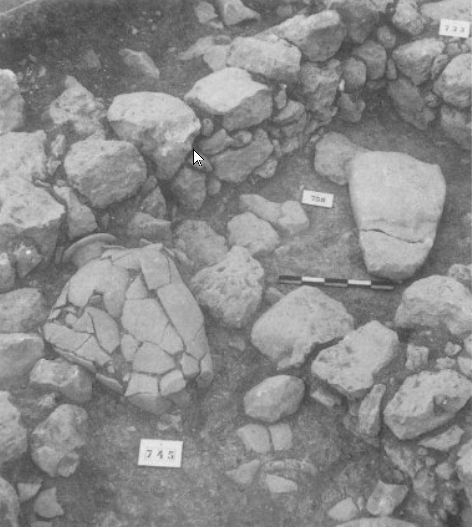
- Storeroom of palace
B1 with crushed pithoi from Stern et al. (2008)
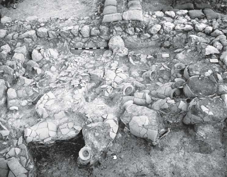 Storeroom of palace B1 with crushed pithoi in situ, looking northwest
click on image to open in a new tab
Stern et al. (2008) - Smashed Pitho in an
an EBIIIB house in Area G, Stratum G-II from de Miroschedji (1999)
 Detail of an EBIIIB house in Area G, Stratum G-II.
The smashed pithos (foreground) was found in a room with a large niche containing a ]
massebah, suggesting a chapel for a domestic cult
Detail of an EBIIIB house in Area G, Stratum G-II.
The smashed pithos (foreground) was found in a room with a large niche containing a ]
massebah, suggesting a chapel for a domestic cult
click on image to open in a new tab
de Miroschedji (1999)
- Storeroom of palace
B1 with crushed pithoi from Stern et al. (2008)
Storeroom of palace B1 with crushed pithoi in situ, looking northwest
click on image to open in a new tab
Stern et al. (2008) - Smashed Pitho in an
an EBIIIB house in Area G, Stratum G-II from de Miroschedji (1999)
Detail of an EBIIIB house in Area G, Stratum G-II.
The smashed pithos (foreground) was found in a room with a large niche containing a ]
massebah, suggesting a chapel for a domestic cult
click on image to open in a new tab
de Miroschedji (1999)
| Effect | Location | Image(s) | Description |
|---|---|---|---|
|
Area Ja
Tel Jarmuth: topographical plan, showing excavation areas and remains of fortifications excavated or traced on the surface click on image to open in a new tab Stern et al. (2008)
Plan of palace B1, areas G (stratum G-2) and J (stratum J-1).
click on image to open in a new tab Stern et al. (2008)
Aerial view of palace B1, looking northeast (1999).
click on image to open in a new tab Stern et al. (2008)
Aerial view of areas Bd, Ja, and K, showing the excavated remains of the fortifications (wall A, gate J, and bastion K), looking northeast.
click on image to open in a new tab Stern et al. (2008) |
|
-
Earthquake Archeological Effects chart
of Rodríguez-Pascua et al (2013: 221-224)
 Earthquake Archeological Effects (EAE)
Rodríguez-Pascua et al (2013: 221-224)
| Effect | Location | Image(s) | Description | Intensity |
|---|---|---|---|---|
|
Area Ja
Tel Jarmuth: topographical plan, showing excavation areas and remains of fortifications excavated or traced on the surface click on image to open in a new tab Stern et al. (2008)
Plan of palace B1, areas G (stratum G-2) and J (stratum J-1).
click on image to open in a new tab Stern et al. (2008)
Aerial view of palace B1, looking northeast (1999).
click on image to open in a new tab Stern et al. (2008)
Aerial view of areas Bd, Ja, and K, showing the excavated remains of the fortifications (wall A, gate J, and bastion K), looking northeast.
click on image to open in a new tab Stern et al. (2008) |
|
|