
Tel Qasile
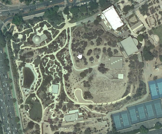 Tel Qasile
click on image to explore this site on a new tab in govmap.gov.il
| Transliterated Name | Source | Name |
|---|---|---|
| Tel Qasile | Hebrew | תל קסילה |
| Tell Qasila | English (variant) | Tell Qasila |
| El Qasile | Arabic (transliterated) | القصيلة |
| El-Khirba | Arabic (historical local name) | الخربة |
- Fig. 1 Location Map
from Mazar (1980)
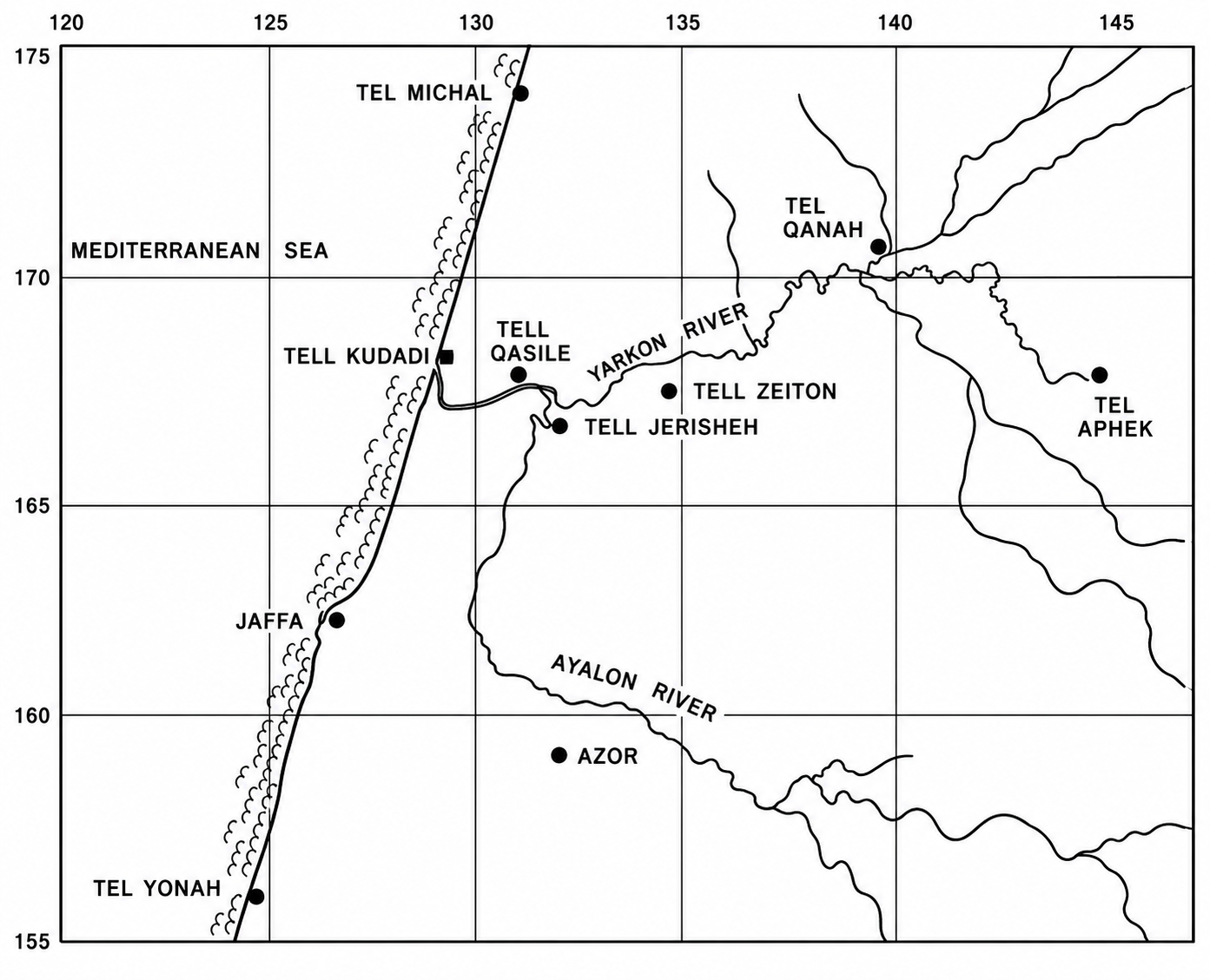 Fig. 1
Map of the sites along the Yarkon River
Click on image to open in a new tab
Mazar (1980)
- Fig. 1 Location Map
from Mazar (1980)
Fig. 1
Map of the sites along the Yarkon River
Click on image to open in a new tab
Mazar (1980)
- Tel Qasile in Google Earth
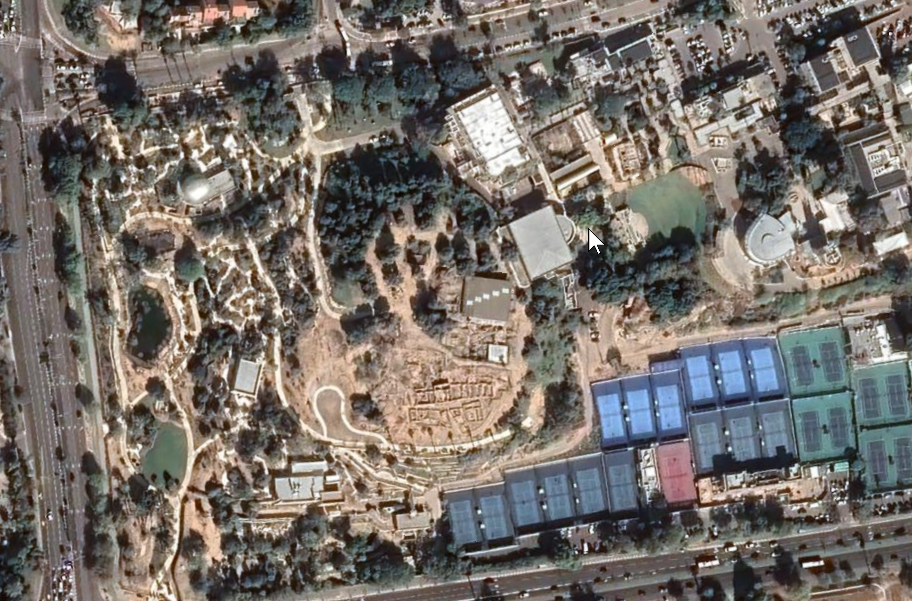 Tel Qasile
click on image to explore this site on a new tab in Google Earth - Tel Qasile on govmap.gov.il
Tel Qasile
click on image to explore this site on a new tab in govmap.gov.il
- Fig. 13.1 Site Plan
of Tel Qasile in Stratum X from Mazar (2026)
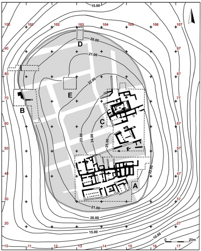 Fig. 13.1
Tel Qasile in Stratum X, with the suggested settled area and street layout
Click on image to open in a new tab
Mazar (2026) - Fig. 2 Site Plan
from Mazar (1980)
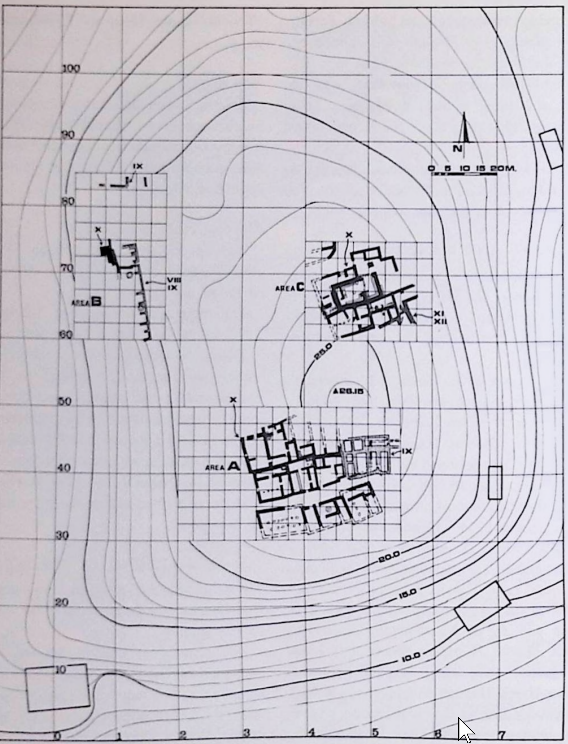 Fig. 2
Contour Map of Tel Qasile, with location of excavated areas
Click on image to open in a new tab
Mazar (1980) - Fig. 13.2 Plan of
Stratum X in Areas A and C from Mazar (2026)
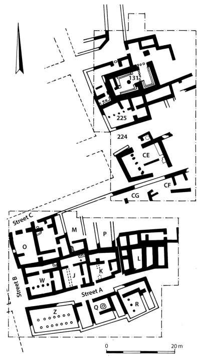 Fig. 13.2
Schematic plan of Stratum X in Areas A and C
Click on image to open in a new tab
Mazar (2026) - Fig. 13.7 Plan of
Stratum X in Areas A and C, showing burnt rooms in red and rooms destroyed without fire in brown from Mazar (2026)
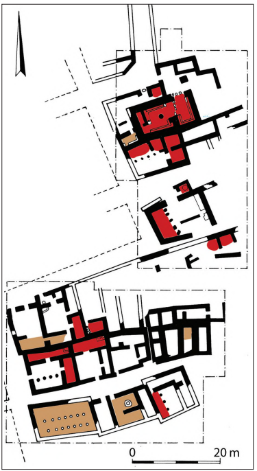 Fig. 13.7
Schematic plan of Stratum X in Areas A and C, showing burnt rooms in red and rooms destroyed without fire in brown
Click on image to open in a new tab
Mazar (2026)
- Fig. 13.1 Site Plan
of Tel Qasile in Stratum X from Mazar (2026)
Fig. 13.1
Tel Qasile in Stratum X, with the suggested settled area and street layout
Click on image to open in a new tab
Mazar (2026) - Fig. 2 Site Plan
from Mazar (1980)
Fig. 2
Contour Map of Tel Qasile, with location of excavated areas
Click on image to open in a new tab
Mazar (1980) - Fig. 13.2 Plan of
Stratum X in Areas A and C from Mazar (2026)
Fig. 13.2
Schematic plan of Stratum X in Areas A and C
Click on image to open in a new tab
Mazar (2026) - Fig. 13.7 Plan of
Stratum X in Areas A and C, showing burnt rooms in red and rooms destroyed without fire in brown from Mazar (2026)
Fig. 13.7
Schematic plan of Stratum X in Areas A and C, showing burnt rooms in red and rooms destroyed without fire in brown
Click on image to open in a new tab
Mazar (2026)
- Fig. 4 Plan of Area C
Stratum XII from Mazar (1980)
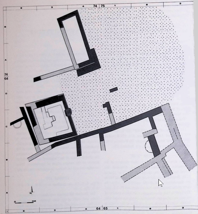 Fig. 4
Area C, Stratum XII, schematic Plan
Click on image to open in a new tab
Mazar (1980) - Fig. 5 suggested
reconstructions of Temple 319 (Stratum XII) from Mazar (1980)
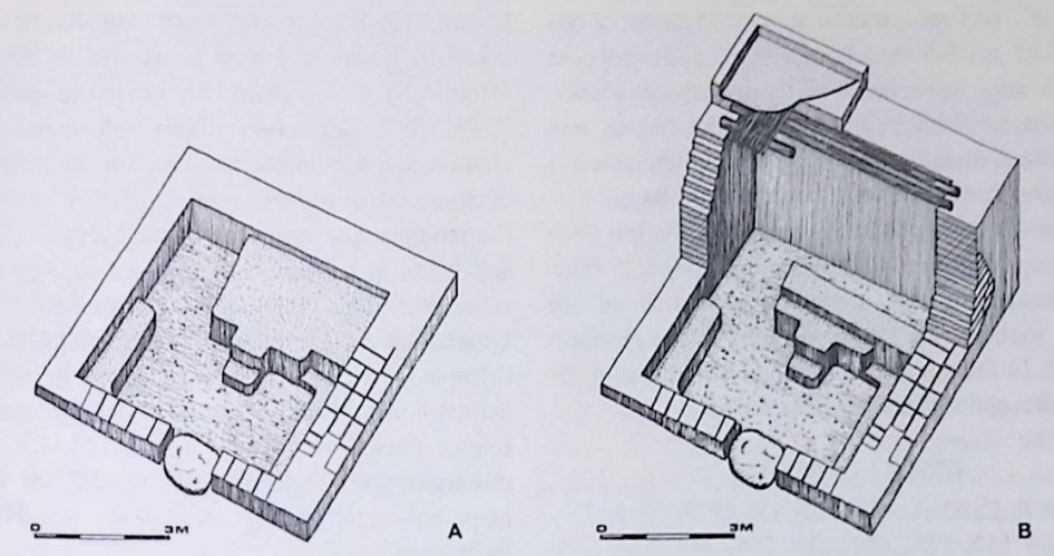 Fig. 5
Two suggested reconstructions of Temple 319 (Stratum XII).
Click on image to open in a new tab
Mazar (1980) - Fig. 9 Plan of Area C
Stratum X from Mazar (1980)
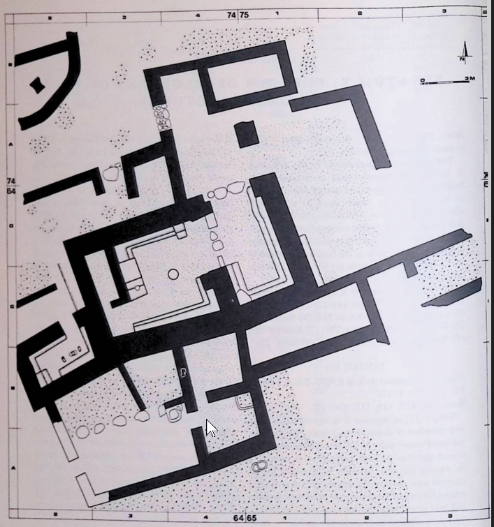 Fig. 9
Area C, Stratum X, schematic Plan
Click on image to open in a new tab
Mazar (1980) - Fig. 10 Isometric
reconstruction of Temple 131 (Stratum X) from Mazar (1980)
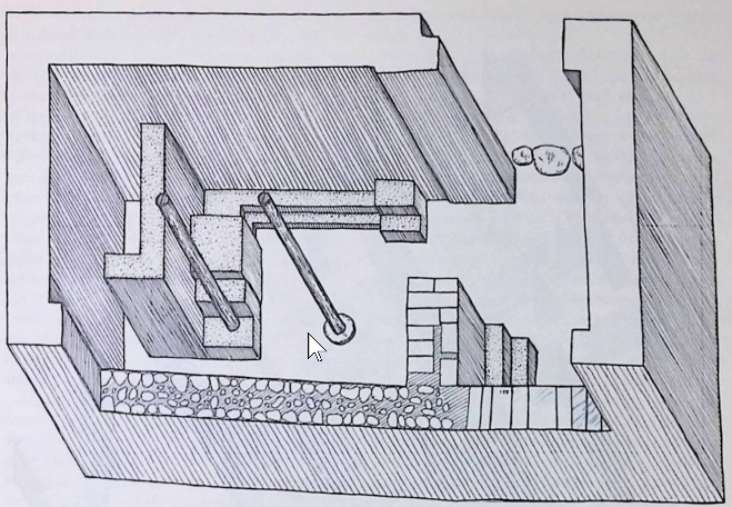 Fig. 10
Isometric reconstruction of Temple 131 (Stratum X)
Click on image to open in a new tab
Mazar (1980) - Fig. 11 Plan of
Temple 131 (Stratum X) with location of finds from Mazar (1980)
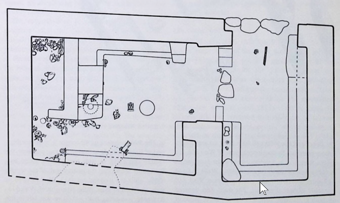 Fig. 11
Plan of Temple 131 (Stratum X) with location of finds
Click on image to open in a new tab
Mazar (1980) - Fig. 12 Exonometric
view of Area C, Stratum X from Mazar (1980)
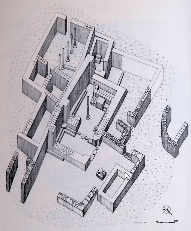 Fig. 12
Exonometric view of Area C, Stratum X; looking south west.
Click on image to open in a new tab
Mazar (1980)
- Fig. 4 Plan of Area C
Stratum XII from Mazar (1980)
Fig. 4
Area C, Stratum XII, schematic Plan
Click on image to open in a new tab
Mazar (1980) - Fig. 5 suggested
reconstructions of Temple 319 (Stratum XII) from Mazar (1980)
Fig. 5
Two suggested reconstructions of Temple 319 (Stratum XII).
Click on image to open in a new tab
Mazar (1980) - Fig. 9 Plan of Area C
Stratum X from Mazar (1980)
Fig. 9
Area C, Stratum X, schematic Plan
Click on image to open in a new tab
Mazar (1980) - Fig. 10 Isometric
reconstruction of Temple 131 (Stratum X) from Mazar (1980)
Fig. 10
Isometric reconstruction of Temple 131 (Stratum X)
Click on image to open in a new tab
Mazar (1980) - Fig. 11 Plan of
Temple 131 (Stratum X) with location of finds from Mazar (1980)
Fig. 11
Plan of Temple 131 (Stratum X) with location of finds
Click on image to open in a new tab
Mazar (1980) - Fig. 12 Exonometric
view of Area C, Stratum X from Mazar (1980)
Fig. 12
Exonometric view of Area C, Stratum X; looking south west.
Click on image to open in a new tab
Mazar (1980)
- Fig. 3 Schematic section
of the Tell from Mazar (1980)
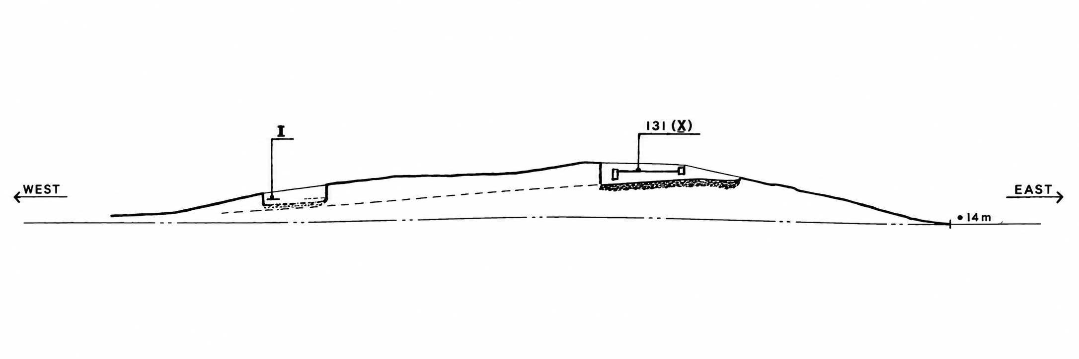 Fig. 3
Schematic section of the Tell, from east to west, looking north
Click on image to open in a new tab
Mazar (1980)
- Fig. 3 Schematic section
of the Tell from Mazar (1980)
Fig. 3
Schematic section of the Tell, from east to west, looking north
Click on image to open in a new tab
Mazar (1980)
- from Mazar (2026)
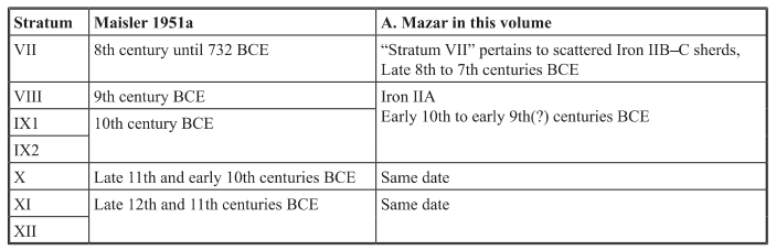 Table 13.3
Suggested dates of the Iron Age strata
click on table to open in a new tab
Mazar (2026)
| Effect | Location | Image(s) | Description |
|---|---|---|---|
| Collapsed Wall | Temple 319 in Area C
Fig. 13.1
Tel Qasile in Stratum X, with the suggested settled area and street layout Click on image to open in a new tab Mazar (2026)
Fig. 4
Area C, Stratum XII, schematic Plan Click on image to open in a new tab Mazar (1980)
Fig. 5
Two suggested reconstructions of Temple 319 (Stratum XII). Click on image to open in a new tab Mazar (1980) |
|
| Effect | Location | Image(s) | Description |
|---|---|---|---|
|
Temple 131, Room 204, and Building 225 in Area C
Fig. 13.1
Tel Qasile in Stratum X, with the suggested settled area and street layout Click on image to open in a new tab Mazar (2026)
Fig. 13.2
Schematic plan of Stratum X in Areas A and C Click on image to open in a new tab Mazar (2026)
Fig. 13.7
Schematic plan of Stratum X in Areas A and C, showing burnt rooms in red and rooms destroyed without fire in brown Click on image to open in a new tab Mazar (2026)
Fig. 9
Area C, Stratum X, schematic Plan Click on image to open in a new tab Mazar (1980)
Fig. 10
Isometric reconstruction of Temple 131 (Stratum X) Click on image to open in a new tab Mazar (1980)
Fig. 11
Plan of Temple 131 (Stratum X) with location of finds Click on image to open in a new tab Mazar (1980)
Fig. 12
Exonometric view of Area C, Stratum X; looking south west. Click on image to open in a new tab Mazar (1980) |
|
|
|
Buildings K, J, W and O in Area A
Fig. 13.1
Tel Qasile in Stratum X, with the suggested settled area and street layout Click on image to open in a new tab Mazar (2026)
Fig. 13.2
Schematic plan of Stratum X in Areas A and C Click on image to open in a new tab Mazar (2026)
Fig. 13.7
Schematic plan of Stratum X in Areas A and C, showing burnt rooms in red and rooms destroyed without fire in brown Click on image to open in a new tab Mazar (2026) |
|
|
|
Shrine 300 and Street 224
Fig. 13.1
Tel Qasile in Stratum X, with the suggested settled area and street layout Click on image to open in a new tab Mazar (2026)
Fig. 13.2
Schematic plan of Stratum X in Areas A and C Click on image to open in a new tab Mazar (2026)
Fig. 13.7
Schematic plan of Stratum X in Areas A and C, showing burnt rooms in red and rooms destroyed without fire in brown Click on image to open in a new tab Mazar (2026) |
|
- Earthquake Archeological Effects chart
of Rodríguez-Pascua et al (2013: 221-224)
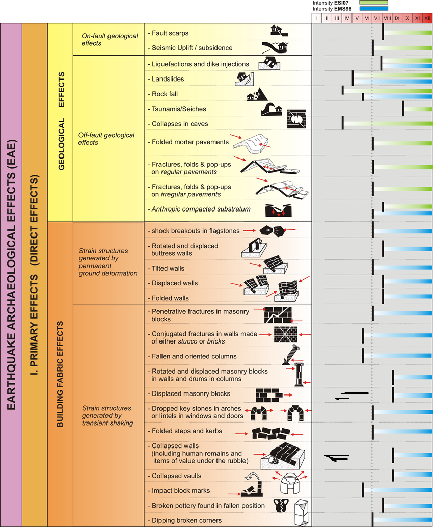 Earthquake Archeological Effects (EAE)
Rodríguez-Pascua et al (2013: 221-224)
| Effect | Location | Image(s) | Description | Intensity |
|---|---|---|---|---|
| Collapsed Wall | Temple 319 in Area C
Fig. 13.1
Tel Qasile in Stratum X, with the suggested settled area and street layout Click on image to open in a new tab Mazar (2026)
Fig. 4
Area C, Stratum XII, schematic Plan Click on image to open in a new tab Mazar (1980)
Fig. 5
Two suggested reconstructions of Temple 319 (Stratum XII). Click on image to open in a new tab Mazar (1980) |
|
VIII+ |
- Earthquake Archeological Effects chart
of Rodríguez-Pascua et al (2013: 221-224)
Earthquake Archeological Effects (EAE)
Rodríguez-Pascua et al (2013: 221-224)
| Effect | Location | Image(s) | Description | Intensity |
|---|---|---|---|---|
|
Temple 131, Room 204, and Building 225 in Area C
Fig. 13.1
Tel Qasile in Stratum X, with the suggested settled area and street layout Click on image to open in a new tab Mazar (2026)
Fig. 13.2
Schematic plan of Stratum X in Areas A and C Click on image to open in a new tab Mazar (2026)
Fig. 13.7
Schematic plan of Stratum X in Areas A and C, showing burnt rooms in red and rooms destroyed without fire in brown Click on image to open in a new tab Mazar (2026)
Fig. 9
Area C, Stratum X, schematic Plan Click on image to open in a new tab Mazar (1980)
Fig. 10
Isometric reconstruction of Temple 131 (Stratum X) Click on image to open in a new tab Mazar (1980)
Fig. 11
Plan of Temple 131 (Stratum X) with location of finds Click on image to open in a new tab Mazar (1980)
Fig. 12
Exonometric view of Area C, Stratum X; looking south west. Click on image to open in a new tab Mazar (1980) |
|
? | |
|
Buildings K, J, W and O in Area A
Fig. 13.1
Tel Qasile in Stratum X, with the suggested settled area and street layout Click on image to open in a new tab Mazar (2026)
Fig. 13.2
Schematic plan of Stratum X in Areas A and C Click on image to open in a new tab Mazar (2026)
Fig. 13.7
Schematic plan of Stratum X in Areas A and C, showing burnt rooms in red and rooms destroyed without fire in brown Click on image to open in a new tab Mazar (2026) |
|
? | |
|
Shrine 300 and Street 224
Fig. 13.1
Tel Qasile in Stratum X, with the suggested settled area and street layout Click on image to open in a new tab Mazar (2026)
Fig. 13.2
Schematic plan of Stratum X in Areas A and C Click on image to open in a new tab Mazar (2026)
Fig. 13.7
Schematic plan of Stratum X in Areas A and C, showing burnt rooms in red and rooms destroyed without fire in brown Click on image to open in a new tab Mazar (2026) |
|
VIII+ |