Et-Tell
 Et-Tell
click on image to explore this site on a new tab in govmap.gov.il
| Transliterated Name | Source | Name |
|---|---|---|
| Et-Tell | Arabic | التل |
| Khirbet et-Tell | Arabic | |
| Ai | Hebrew | הָעַ |
- Location Map from
Stern et al. (1993 v. 1)
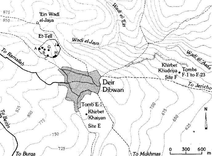 Location Map
Ai: Map of the Mound and its Environs
click on image to open in a new tab
Stern et al. (1993 v. 1)
- Location Map from
Stern et al. (1993 v. 1)
Location Map
Ai: Map of the Mound and its Environs
click on image to open in a new tab
Stern et al. (1993 v. 1)
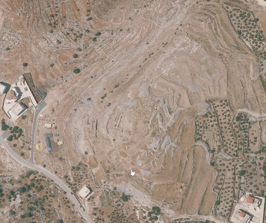
- Et-Tell in Google Earth
 Et-Tell
click on image to explore this site on a new tab in Google Earth - Et-Tell on govmap.gov.il
Et-Tell
click on image to explore this site on a new tab in govmap.gov.il
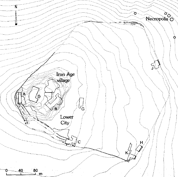
- Fig.1 City plan of Ai
(et-Tell) from Callaway & Schoonover (1972)
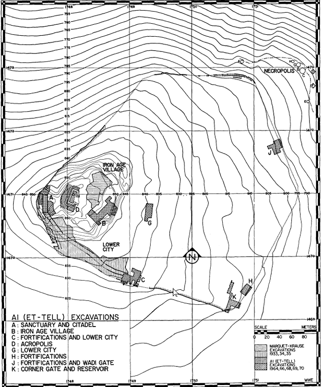 Fig. 1
City plan of Ai (et-Tell) with sites excavated 1964-1970.
click on image to open in a new tab
Callaway & Schoonover (1972) - Map of the Mound and
Excavation Areas from Stern et al. (1993 v. 1)
 Location Map
Map of the Mound and Excavation Areas
click on image to open in a new tab
Stern et al. (1993 v. 1)
- Fig.1 City plan of Ai
(et-Tell) from Callaway & Schoonover (1972)
Fig. 1
City plan of Ai (et-Tell) with sites excavated 1964-1970.
click on image to open in a new tab
Callaway & Schoonover (1972) - Map of the Mound and
Excavation Areas from Stern et al. (1993 v. 1)
Location Map
Map of the Mound and Excavation Areas
click on image to open in a new tab
Stern et al. (1993 v. 1)
- Fig. 2 The EB IC Citadel
Tower and Gate, Phase III of Site A strata from Callaway & Schoonover (1972)
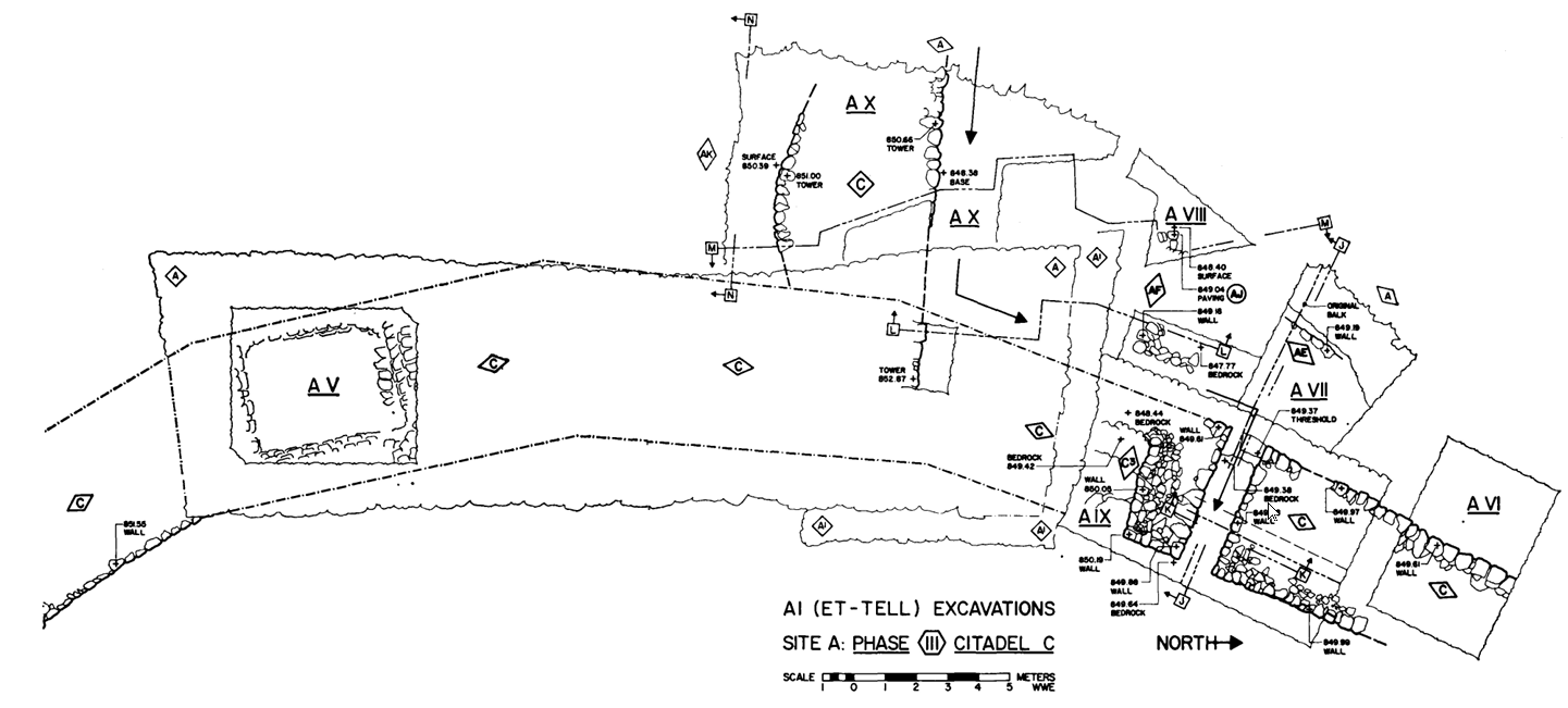 Fig. 2
The EB IC Citadel Tower and Gate, Phase III of Site A strata
click on image to open in a new tab
Callaway & Schoonover (1972) - Fig. 5 The EB IIA Citadel
Tower and City Wall, Phase IV of Site A strata from Callaway & Schoonover (1972)
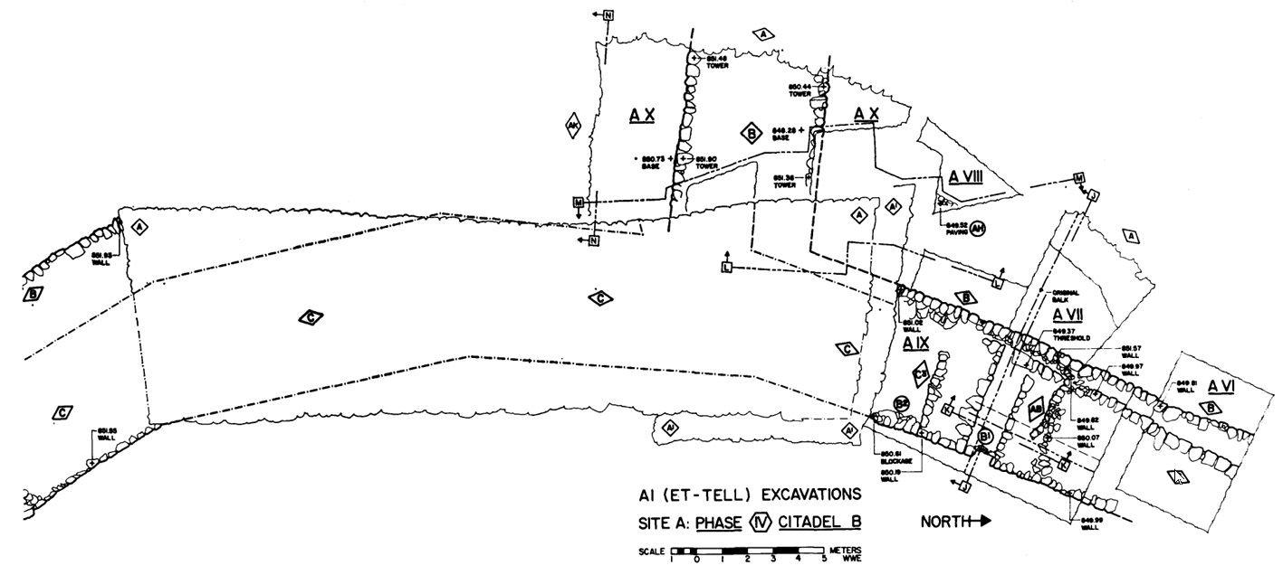 Fig. 5
The EB IIA Citadel Tower and City Wall, Phase IV of Site A strata
click on image to open in a new tab
Callaway & Schoonover (1972)
- Fig. 2 The EB IC Citadel
Tower and Gate, Phase III of Site A strata from Callaway & Schoonover (1972)
Fig. 2
The EB IC Citadel Tower and Gate, Phase III of Site A strata
click on image to open in a new tab
Callaway & Schoonover (1972) - Fig. 5 The EB IIA Citadel
Tower and City Wall, Phase IV of Site A strata from Callaway & Schoonover (1972)
Fig. 5
The EB IIA Citadel Tower and City Wall, Phase IV of Site A strata
click on image to open in a new tab
Callaway & Schoonover (1972)
- Fig. 11 Section B-B
from Callaway and Ellinger (1972)
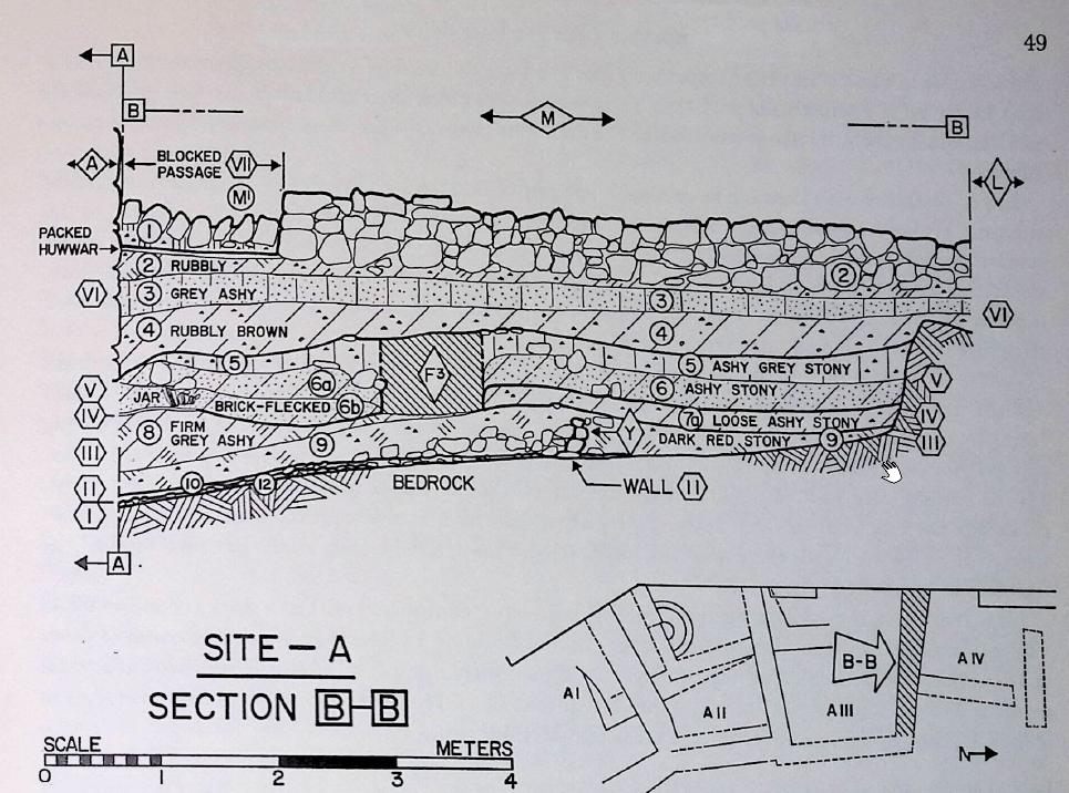 Fig. 11
Section B-B, the south face of the Wall M balk in area III.
click on image to open in a new tab
Callaway and Ellinger (1972)
- Fig. 11 Section B-B
from Callaway and Ellinger (1972)
Fig. 11
Section B-B, the south face of the Wall M balk in area III.
click on image to open in a new tab
Callaway and Ellinger (1972)
- Plate IX.2 Phase V
destruction layer in Building B from Callaway and Ellinger (1972)
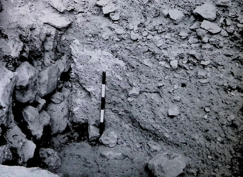 Plate IX.2
Detail of Phase V destruction layer, behind half-meter scale, on the Building B floor and against the north face of Wall Q in Area III.
click on image to open in a new tab
Callaway and Ellinger (1972) - Plate X.1 Phase V
destruction layer in Building B from Callaway and Ellinger (1972)
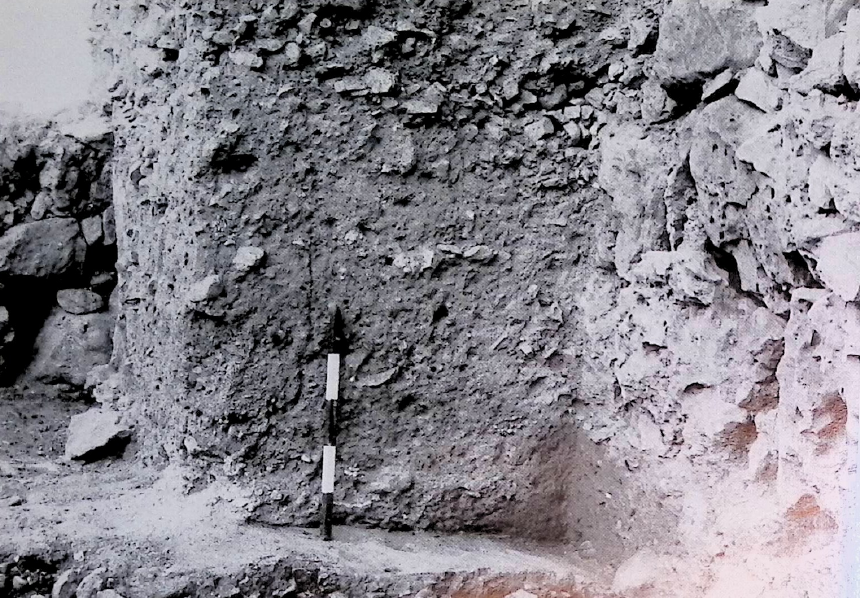 Plate X.1
Detail of Building B floor at the north end of Sanctuary A altar balk with Phase V layer at the left of the half-meter scale
click on image to open in a new tab
Callaway and Ellinger (1972) - Plate X.2 Crushed Jar
on Building B floor from Callaway and Ellinger (1972)
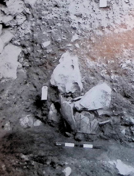 Plate X.2
Crushed ledge-handle jar on Building B floor in Area III, against Wall M balk (See Fig. 46:13)
click on image to open in a new tab
Callaway and Ellinger (1972) - Plate XV.1 Calcined
mass from Phase V fire from Callaway and Ellinger (1972)
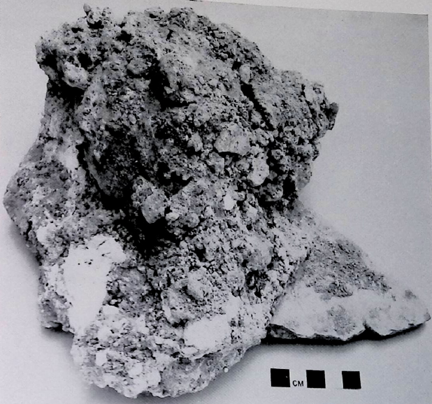 Plate XV.1
Small flat-base jar in calcined mass cemented to outside of large store-jar sherd, from the ashes of Phase V in Area III
click on image to open in a new tab
Callaway and Ellinger (1972) - Plate XVI.1 Leaf
impressions in Phase V destruction Layer from Callaway and Ellinger (1972)
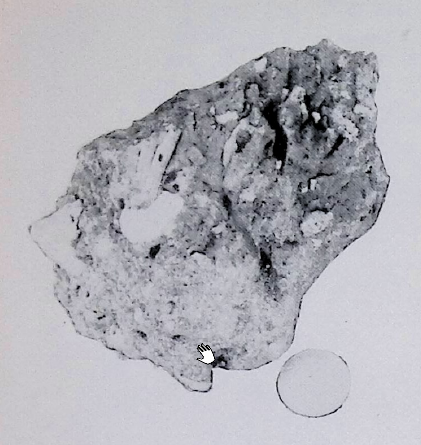 Plate XVI.1
Impressions of leaves in Phase V destruction debris on Building B floor, Area III. The coin Jordanian fifty fils.
click on image to open in a new tab
Callaway and Ellinger (1972) - Plate XVI.2 Leaf
impressions in Phase V destruction Layer from Callaway and Ellinger (1972)
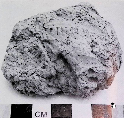 Plate XVI.2
Leaf imprints in baked clay, Phase V, Area III
click on image to open in a new tab
Callaway and Ellinger (1972) - Plate XVI.3 Leaf
impressions in Phase V destruction Layer from Callaway and Ellinger (1972)
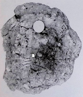 Plate XVI.3
Impressions of leaves in baked clay, Phase V Area III. The coin is Jordanian fifty fils.
click on image to open in a new tab
Callaway and Ellinger (1972) - Plate XVI.4 Leaf
impressions in Phase V destruction Layer from Callaway and Ellinger (1972)
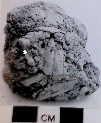 Plate XVI.4
Leaf imprints in baked clay, Phase V, Area III.
click on image to open in a new tab
Callaway and Ellinger (1972)
- Plate IX.2 Phase V
destruction layer in Building B from Callaway and Ellinger (1972)
Plate IX.2
Detail of Phase V destruction layer, behind half-meter scale, on the Building B floor and against the north face of Wall Q in Area III.
click on image to open in a new tab
Callaway and Ellinger (1972) - Plate X.1 Phase V
destruction layer in Building B from Callaway and Ellinger (1972)
Plate X.1
Detail of Building B floor at the north end of Sanctuary A altar balk with Phase V layer at the left of the half-meter scale
click on image to open in a new tab
Callaway and Ellinger (1972) - Plate X.2 Crushed Jar
on Building B floor from Callaway and Ellinger (1972)
Plate X.2
Crushed ledge-handle jar on Building B floor in Area III, against Wall M balk (See Fig. 46:13)
click on image to open in a new tab
Callaway and Ellinger (1972) - Plate XV.1 Calcined
mass from Phase V fire from Callaway and Ellinger (1972)
Plate XV.1
Small flat-base jar in calcined mass cemented to outside of large store-jar sherd, from the ashes of Phase V in Area III
click on image to open in a new tab
Callaway and Ellinger (1972) - Plate XVI.1 Leaf
impressions in Phase V destruction Layer from Callaway and Ellinger (1972)
Plate XVI.1
Impressions of leaves in Phase V destruction debris on Building B floor, Area III. The coin Jordanian fifty fils.
click on image to open in a new tab
Callaway and Ellinger (1972) - Plate XVI.2 Leaf
impressions in Phase V destruction Layer from Callaway and Ellinger (1972)
Plate XVI.2
Leaf imprints in baked clay, Phase V, Area III
click on image to open in a new tab
Callaway and Ellinger (1972) - Plate XVI.3 Leaf
impressions in Phase V destruction Layer from Callaway and Ellinger (1972)
Plate XVI.3
Impressions of leaves in baked clay, Phase V Area III. The coin is Jordanian fifty fils.
click on image to open in a new tab
Callaway and Ellinger (1972) - Plate XVI.4 Leaf
impressions in Phase V destruction Layer from Callaway and Ellinger (1972)
Plate XVI.4
Leaf imprints in baked clay, Phase V, Area III.
click on image to open in a new tab
Callaway and Ellinger (1972)
 Table 1
A chronological scheme for the Levant (after Finkelstein 2010 and 2011; Regev et al. 2012; Sharon 2013).
Palmisano et al. (2019)
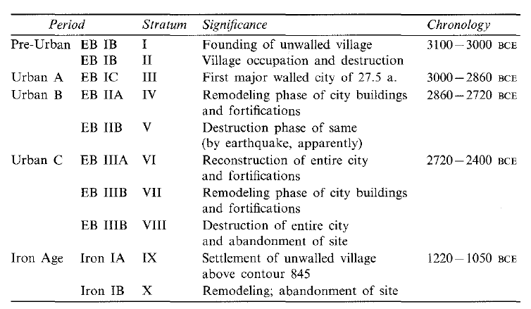 Et-Tell Stratigraphy
click on image to open in a new tab
Stern et al. (1993 v. 1)
| Effect | Location | Image(s) | Description |
|---|---|---|---|
|
Every Excavated Site
Fig. 1 City plan of Ai (et-Tell) with sites excavated 1964-1970. click on image to open in a new tab Callaway & Schoonover (1972) |
Fig. 11
Fig. 11 Section B-B, the south face of the Wall M balk in area III. click on image to open in a new tab Callaway and Ellinger (1972) Plate IX.2
Plate IX.2Detail of Phase V destruction layer, behind half-meter scale, on the Building B floor and against the north face of Wall Q in Area III. click on image to open in a new tab Callaway and Ellinger (1972) Plate X.1
Plate X.1Detail of Building B floor at the north end of Sanctuary A altar balk with Phase V layer at the left of the half-meter scale click on image to open in a new tab Callaway and Ellinger (1972) Plate X.2
Plate X.2Crushed ledge-handle jar on Building B floor in Area III, against Wall M balk (See Fig. 46:13) click on image to open in a new tab Callaway and Ellinger (1972) Plate XV.1
Plate XV.1Small flat-base jar in calcined mass cemented to outside of large store-jar sherd, from the ashes of Phase V in Area III click on image to open in a new tab Callaway and Ellinger (1972) Plate XVI.1
Plate XVI.1Impressions of leaves in Phase V destruction debris on Building B floor, Area III. The coin Jordanian fifty fils. click on image to open in a new tab Callaway and Ellinger (1972) Plate XVI.2
Plate XVI.2Leaf imprints in baked clay, Phase V, Area III click on image to open in a new tab Callaway and Ellinger (1972) Plate XVI.3
Plate XVI.3Impressions of leaves in baked clay, Phase V Area III. The coin is Jordanian fifty fils. click on image to open in a new tab Callaway and Ellinger (1972) Plate XVI.4
Plate XVI.4Leaf imprints in baked clay, Phase V, Area III. click on image to open in a new tab Callaway and Ellinger (1972) |
|
- Earthquake Archeological Effects chart
of Rodríguez-Pascua et al (2013: 221-224)
 Earthquake Archeological Effects (EAE)
Rodríguez-Pascua et al (2013: 221-224) - Environmental Effects (ESI 2007)
 Graphic Representation of ESI 2007 Intensity
click on image to open a higher resolution version in a new tab
- Synoptic Table of ESI 2007
Intensity Degrees from Michetti et al. (2007)
 Plate I
Synoptic Table of ESI 2007 Intensity Degrees - The accuracy of the assessment improves in the higher degrees of the scale, in particular in the range of occurrence of primary effects, typically starting from intensity VIII, and with growing resolution for intensity IX, X, XI and XII. Hence, in the yellow group of intensity degrees (XI-XII) they become the most effective tool for intensity assessment.
click on image to open a higher resolution version in a new tab
Michetti et al. (2007)

| Effect | Location | Image(s) | Description | Intensity |
|---|---|---|---|---|
|
Every Excavated Site
Fig. 1 City plan of Ai (et-Tell) with sites excavated 1964-1970. click on image to open in a new tab Callaway & Schoonover (1972) |
Fig. 11
Fig. 11 Section B-B, the south face of the Wall M balk in area III. click on image to open in a new tab Callaway and Ellinger (1972) Plate IX.2
Plate IX.2Detail of Phase V destruction layer, behind half-meter scale, on the Building B floor and against the north face of Wall Q in Area III. click on image to open in a new tab Callaway and Ellinger (1972) Plate X.1
Plate X.1Detail of Building B floor at the north end of Sanctuary A altar balk with Phase V layer at the left of the half-meter scale click on image to open in a new tab Callaway and Ellinger (1972) Plate X.2
Plate X.2Crushed ledge-handle jar on Building B floor in Area III, against Wall M balk (See Fig. 46:13) click on image to open in a new tab Callaway and Ellinger (1972) Plate XV.1
Plate XV.1Small flat-base jar in calcined mass cemented to outside of large store-jar sherd, from the ashes of Phase V in Area III click on image to open in a new tab Callaway and Ellinger (1972) Plate XVI.1
Plate XVI.1Impressions of leaves in Phase V destruction debris on Building B floor, Area III. The coin Jordanian fifty fils. click on image to open in a new tab Callaway and Ellinger (1972) Plate XVI.2
Plate XVI.2Leaf imprints in baked clay, Phase V, Area III click on image to open in a new tab Callaway and Ellinger (1972) Plate XVI.3
Plate XVI.3Impressions of leaves in baked clay, Phase V Area III. The coin is Jordanian fifty fils. click on image to open in a new tab Callaway and Ellinger (1972) Plate XVI.4
Plate XVI.4Leaf imprints in baked clay, Phase V, Area III. click on image to open in a new tab Callaway and Ellinger (1972) |
|
|