Beitin
 The ruins of Beitin, the site of ancient Bethel, during the 19th century
Click on image to view at a higher resolution in a new tab
Wikipedia - Francis Firth - donated to Wikimedia Commons as part of a project by the Metropolitan Museum of Art - CC0 1.0 Universal Public Domain
| Transliterated Name | Source/Language | Name |
|---|---|---|
| Beitīn | Arabic | بيتين |
| Bethel, Beth El, Beth-El, Beit El | Biblical/Hebrew | בֵּית־אֵל |
| Luz | Canaanite? | |
| Bethel | Greek (Septuagint) | Βαιθηλ |
| Bethel | Latin (Vulgate) | Bethel |
| Beitin (modern) | English | Beitin |
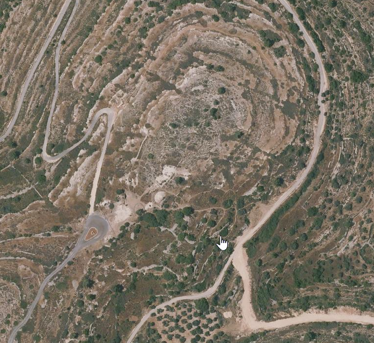
- Annotated Satellite View
of Beitin (Bethel) from BibleWalks.com
 Annotated Satellite View of Beitin (Bethel)
click on image to explore to open in a new tab
Used with permission from BibleWalks.com - Annotated Aerial View
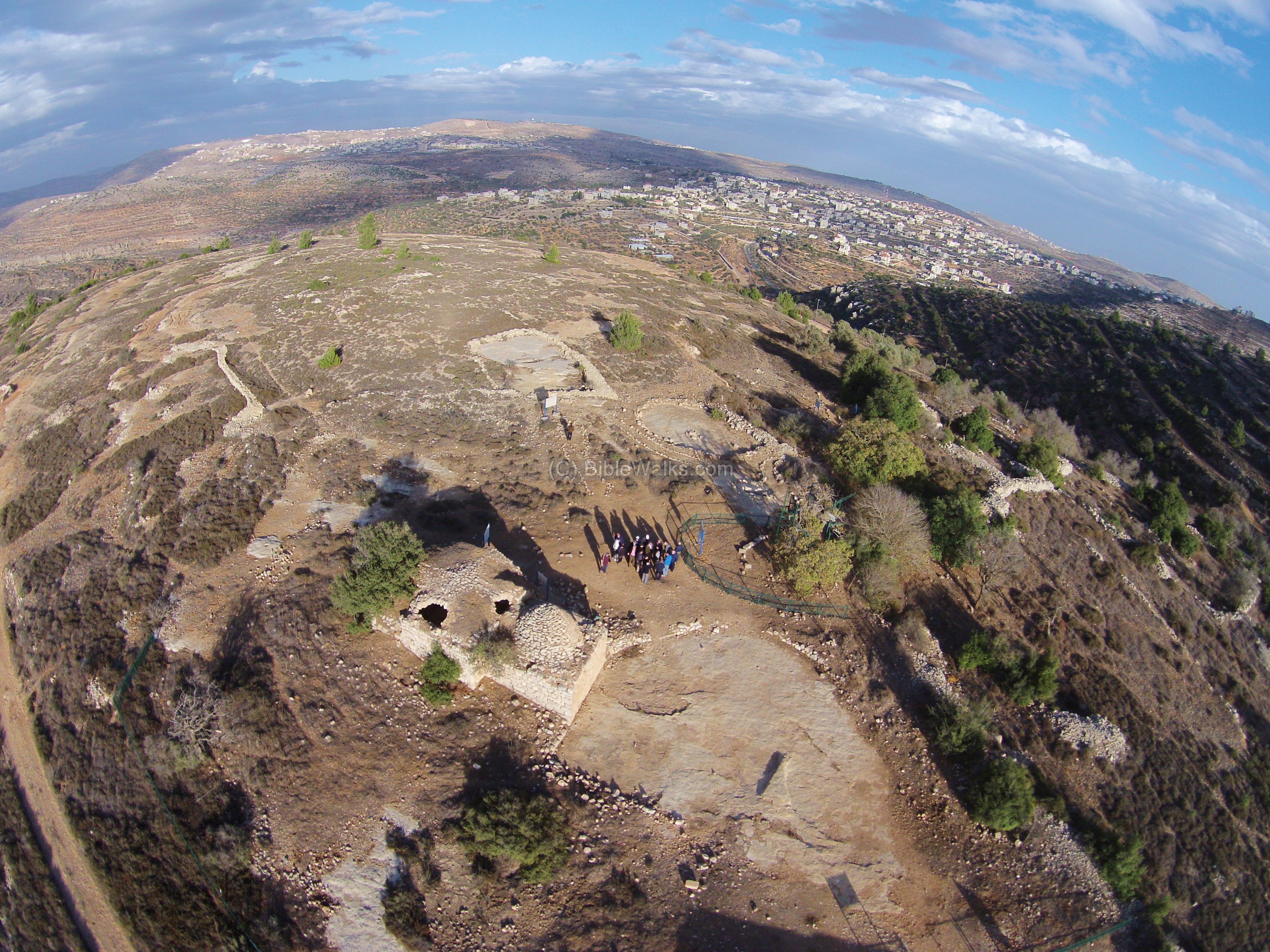
of Beitin (Bethel) from BibleWalks.com
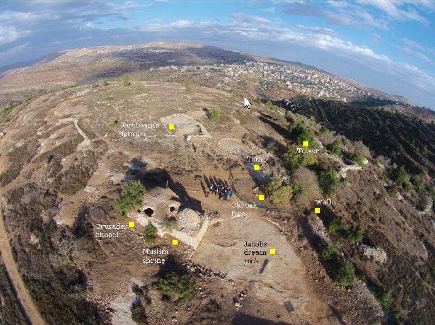 Annotated AerialView of Beitin (Bethel)
click on image to open a high resolution image in a new tab
Used with permission from BibleWalks.com - Unannotated Aerial View
of Beitin (Bethel) from BibleWalks.com
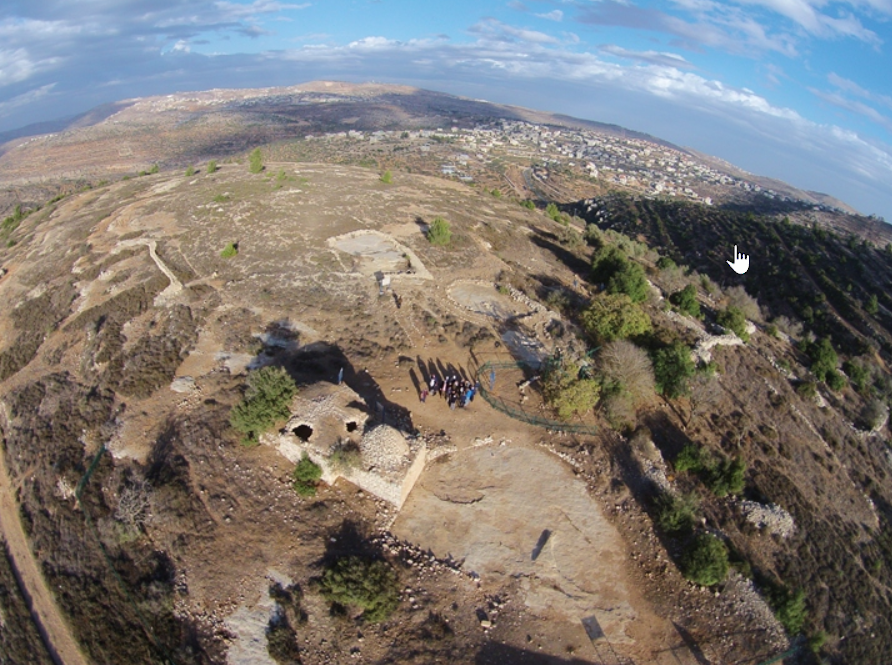 Unannotated AerialView of Beitin (Bethel)
click on image to open a high resolution image in a new tab
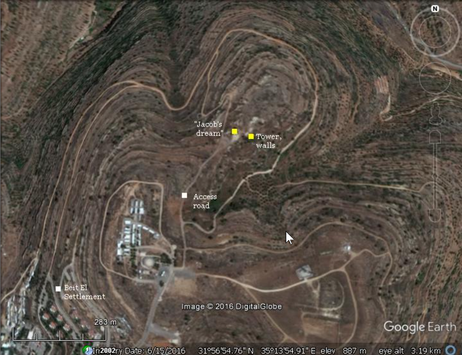
Used with permission from BibleWalks.com - Beitin in Google Earth
 Beitin
click on image to explore this site on a new tab in Google Earth - Beitin on govmap.gov.il
 Beitin
click on image to explore this site on a new tab in govmap.gov.il
- Pl. 1 Plan of Excavated
Areas Bethel 1934 from Kelso et al. (1968)
 Plate 1
Plan of Excavated Areas Bethel 1934
Kelso et al. (1968) - Pl. 120 Plan of Excavated
Areas 1934 through 1960 from Kelso et al. (1968)
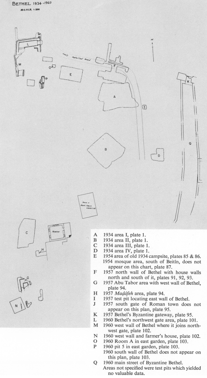 Plate 120
Plan of Excavated Areas 1934 through 1960
Kelso et al. (1968)
- Pl. 1 Plan of Excavated
Areas Bethel 1934 from Kelso et al. (1968)
Plate 1
Plan of Excavated Areas Bethel 1934
Kelso et al. (1968) - Pl. 120 Plan of Excavated
Areas 1934 through 1960 from Kelso et al. (1968)
Plate 120
Plan of Excavated Areas 1934 through 1960
Kelso et al. (1968)
- Pl. 2 Area I -
Middle Bronze I and II from Kelso et al. (1968)
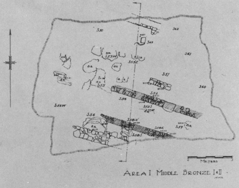 Plate 2
Area I - Middle Bronze I and II
click on image to open in a new tab
Kelso et al. (1968) - Pl. 3 Area I -
Late Bronze Phases 1 and 2 from Kelso et al. (1968)
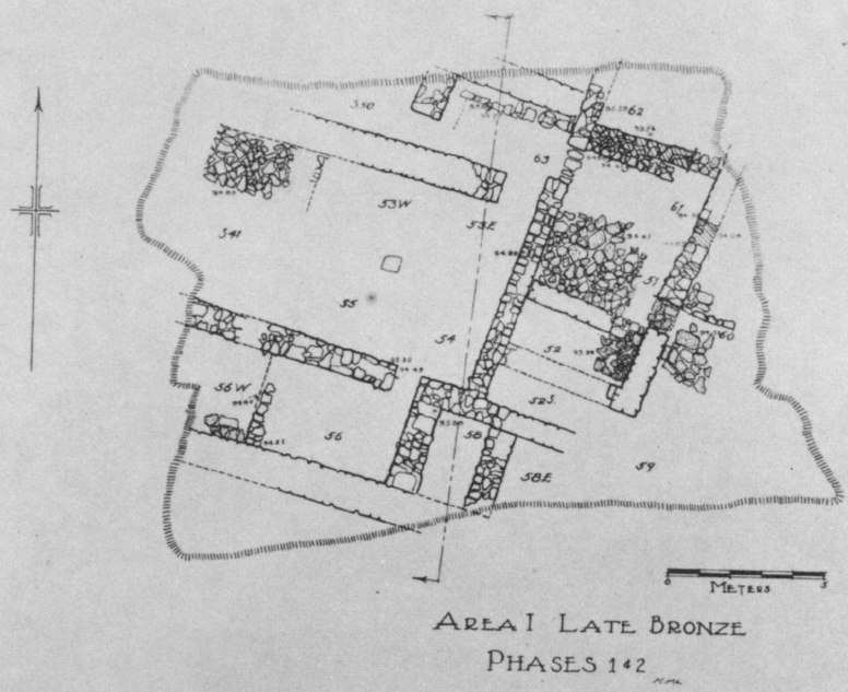 Plate 3
Area I - Late Bronze Phases 1 and 2
click on image to open in a new tab
Kelso et al. (1968)
- Pl. 2 Area I -
Middle Bronze I and II from Kelso et al. (1968)
Plate 2
Area I - Middle Bronze I and II
click on image to open in a new tab
Kelso et al. (1968) - Pl. 3 Area I -
Late Bronze Phases 1 and 2 from Kelso et al. (1968)
Plate 3
Area I - Late Bronze Phases 1 and 2
click on image to open in a new tab
Kelso et al. (1968)
- Pl. 2 Area II -
Middle Bronze I and II from Kelso et al. (1968)
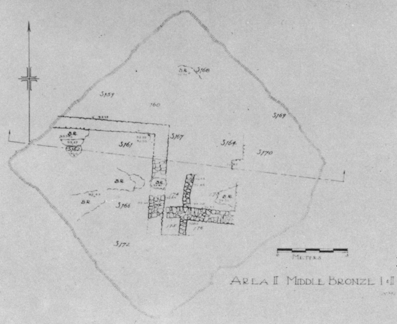 Plate 2
Area II - Middle Bronze I and II
click on image to open in a new tab
Kelso et al. (1968) - Pl. 3 Area II -
Late Bronze Phases 1 and 2 from Kelso et al. (1968)
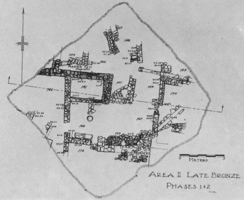 Plate 3
Area II - Late Bronze Phases 1 and 2
click on image to open in a new tab
Kelso et al. (1968)
- Pl. 2 Area II -
Middle Bronze I and II from Kelso et al. (1968)
Plate 2
Area II - Middle Bronze I and II
click on image to open in a new tab
Kelso et al. (1968) - Pl. 3 Area II -
Late Bronze Phases 1 and 2 from Kelso et al. (1968)
Plate 3
Area II - Late Bronze Phases 1 and 2
click on image to open in a new tab
Kelso et al. (1968)
- Pl. 101 Plan and elevations
Middle Bronze II Gateway Complex and Middle Bronze I Cananite high place from Kelso et al. (1968)
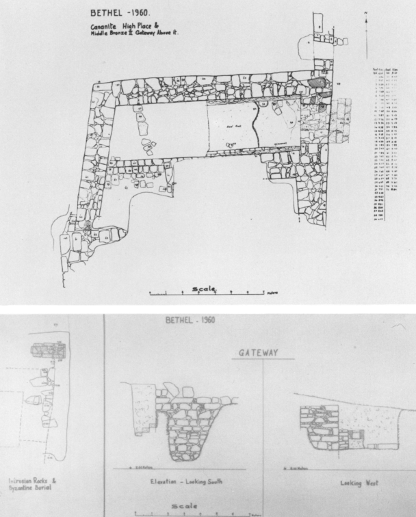 Plate 101
Plan and Elevation of Middle Bronze II Gateway Complex and Cananite high place. The latter is shown in the right half of the long east-weat passageway. The nortwest city gate, with the three steps outside it, is at the east end of the Passageway. Steps also lead up from the west end of the passageway toward the south. Then the gateway turns east. The Haram area lies north of the city gate.
Kelso et al. (1968)
- Pl. 101 Plan and elevations
Middle Bronze II Gateway Complex and Middle Bronze I Cananite high place from Kelso et al. (1968)
Plate 101
Plan and Elevation of Middle Bronze II Gateway Complex and Cananite high place. The latter is shown in the right half of the long east-weat passageway. The nortwest city gate, with the three steps outside it, is at the east end of the Passageway. Steps also lead up from the west end of the passageway toward the south. Then the gateway turns east. The Haram area lies north of the city gate.
Kelso et al. (1968)
- Pl. 94a West Wall
of City in Abu Tabar area from Kelso et al. (1968)
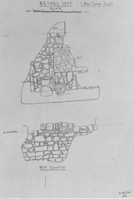 Plate 94a
West Wall of City in Abu Tabar area
click on image to open in a new tab
Kelso et al. (1968)
- Pl. 94a West Wall
of City in Abu Tabar area from Kelso et al. (1968)
Plate 94a
West Wall of City in Abu Tabar area
click on image to open in a new tab
Kelso et al. (1968)
- Pl. 94a Madafeh area
from Kelso et al. (1968)
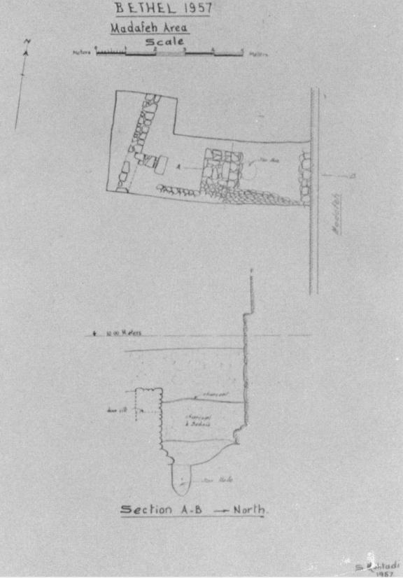 Plate 94b
Madafeh area
click on image to open in a new tab
Kelso et al. (1968)
- Pl. 94a Madafeh area
from Kelso et al. (1968)
Plate 94b
Madafeh area
click on image to open in a new tab
Kelso et al. (1968)
- Pl. 10 Area I Section
from Kelso et al. (1968)
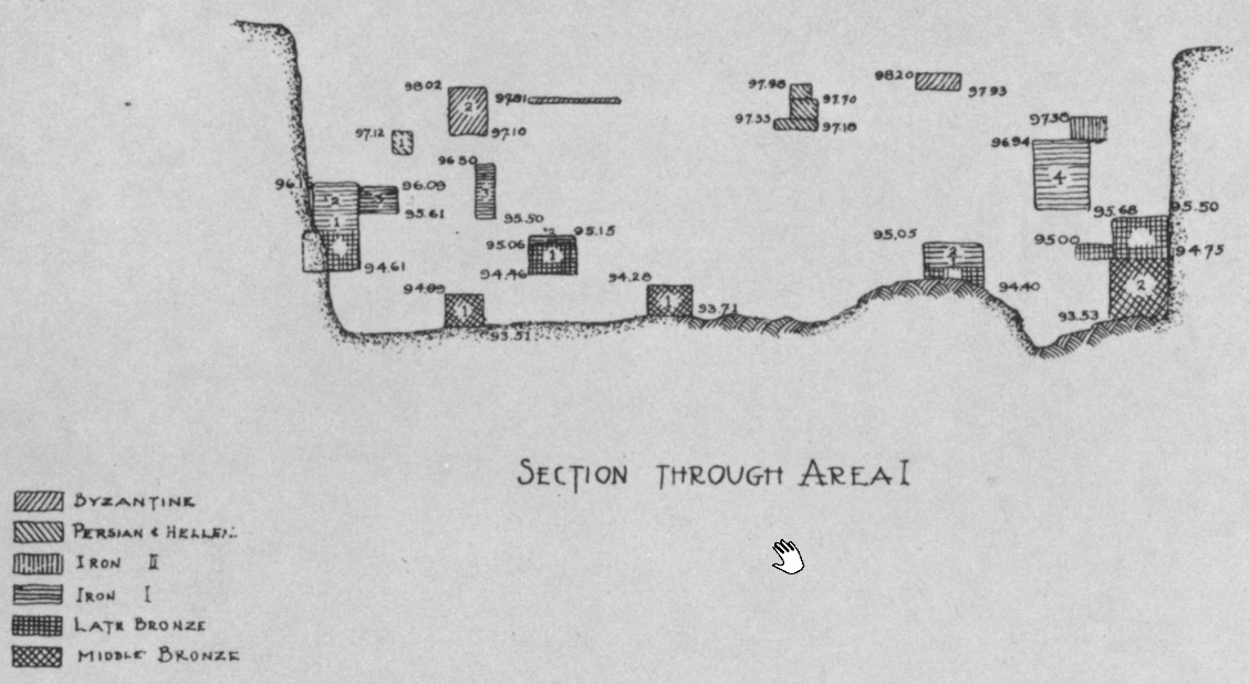 Plate 10
Area I Section
click on image to open in a new tab
Kelso et al. (1968)
- Pl. 10 Area I Section
from Kelso et al. (1968)
Plate 10
Area I Section
click on image to open in a new tab
Kelso et al. (1968)
- Pl. 10 Area II Section
from Kelso et al. (1968)
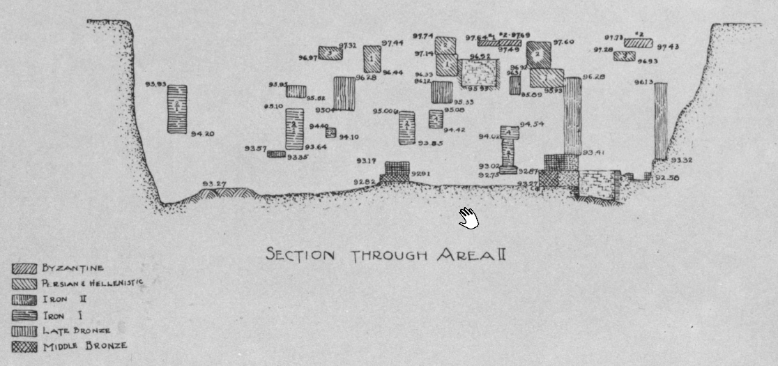 Plate 10
Area II Section
click on image to open in a new tab
Kelso et al. (1968)
- Pl. 10 Area II Section
from Kelso et al. (1968)
Plate 10
Area II Section
click on image to open in a new tab
Kelso et al. (1968)
- 19th century photo of
the ruins of Beitin from wikipedia
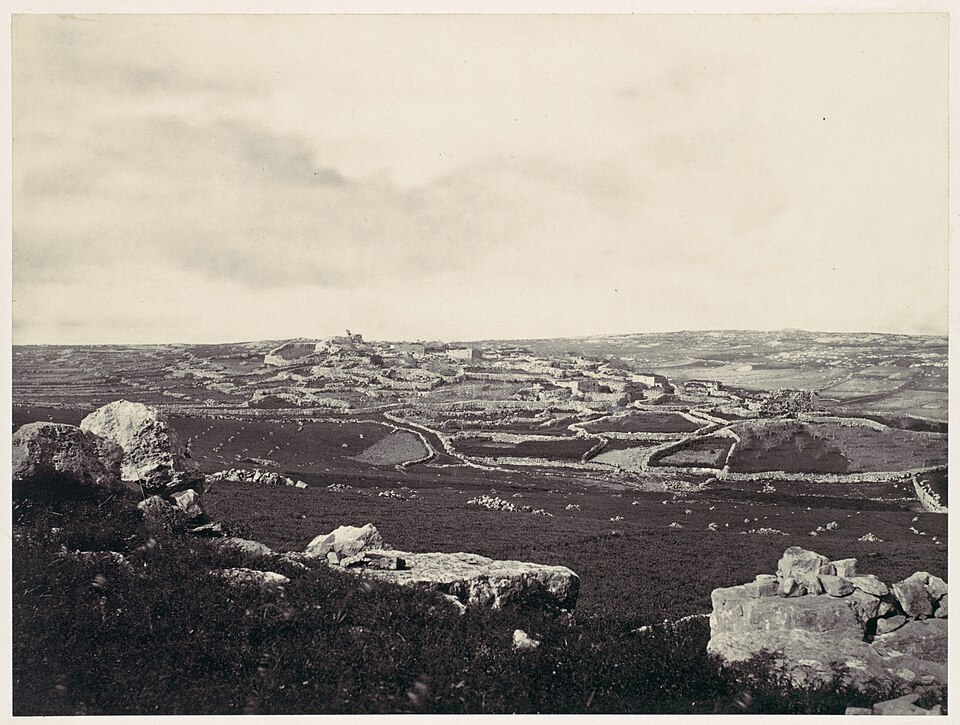 The ruins of Beitin, the site of ancient Bethel, during the 19th century
Click on image to view at a higher resolution in a new tab
Wikipedia - Francis Firth - donated to Wikimedia Commons as part of a project by the Metropolitan Museum of Art - CC0 1.0 Universal Public Domain - Pl. 14a Earthquake Collapsed
Wall of LB II phase I from Kelso et al. (1968)
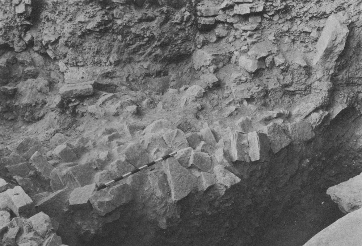 Plate 14a
Wall of LB II phase I destroyed by earthquake and left as it fell.
Kelso et al. (1968) - Pl. 14b Thick Ash Layer
from destruction of LB II city in area II from Kelso et al. (1968)
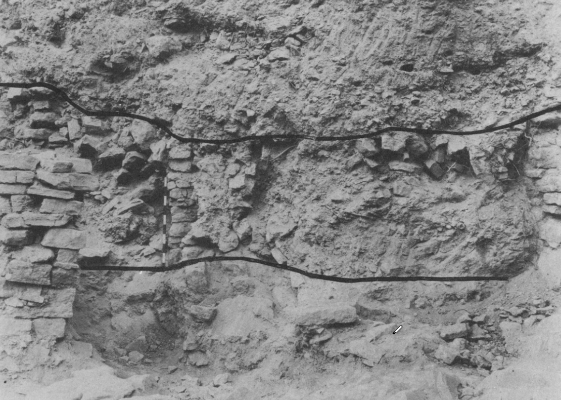 Plate 14b
Over a meter of ashes in destruction of LB II city (area II) shown between the wavy black lines
Kelso et al. (1968) - Pl. 15a LB II and MB II
walls from Kelso et al. (1968)
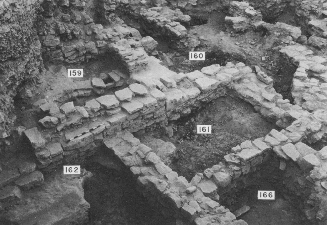 Plate 15a
LB II walls of thin flat stones characteristic of that period. Under them with larger well-shaped stones are MB II walls. Note a drain in upper left
Click on image to open in a new tab
Kelso et al. (1968) - Pl. 15b Area I walls
(MB to Iron I) from Kelso et al. (1968)
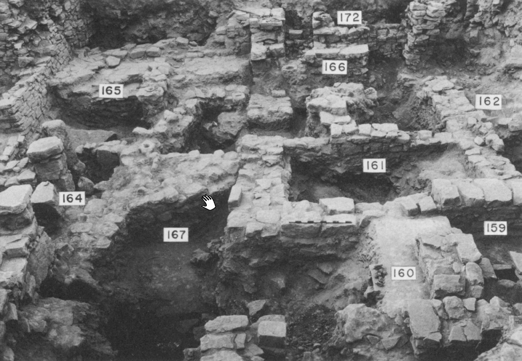 Plate 15b
General view of Area II. Higher walls are Iron I. Note pillar construction at extreme left. Lower walls are LB over MB II. Dark areas ae bedrock on virgin soil.
Click on image to open in a new tab
Kelso et al. (1968) - Pl. 16a LB II, Iron I,
and Iron II walls in Area II from Kelso et al. (1968)
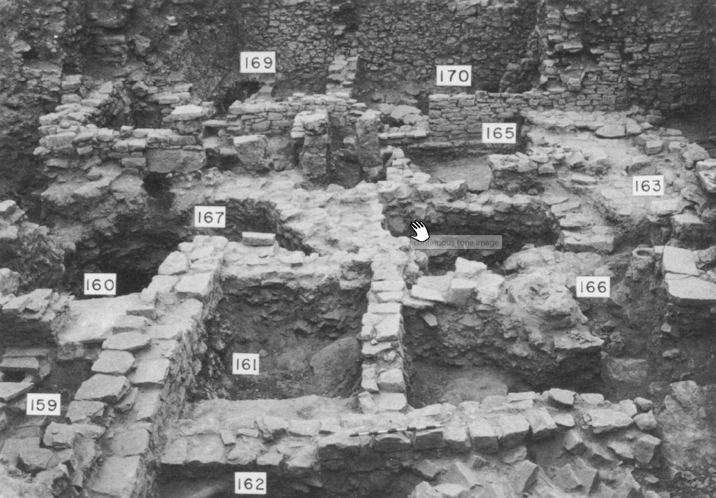 Plate 16a
General view of Area II. LB II walls in the foreground. Iron I and Iron II in background.
Click on image to open in a new tab
Kelso et al. (1968) - Pl. 16b Iron I, Iron II,
and Hellenistic walls in LB II area in area II from Kelso et al. (1968)
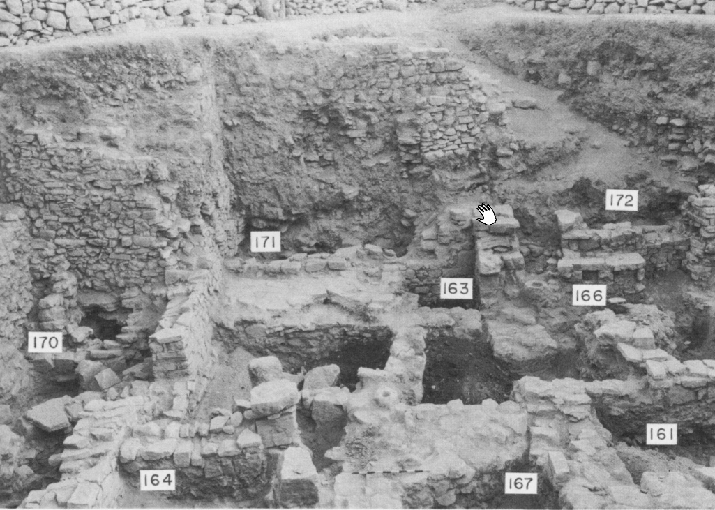 Plate 16b
LB II area II. Stone pavements in left center. Stone table near center of right edge. Walls in background are Iron I, Iron II, and Hellenistic
Click on image to open in a new tab
Kelso et al. (1968) - Pl. 18b Blocked doorway
from phase 2 of LB II from Kelso et al. (1968)
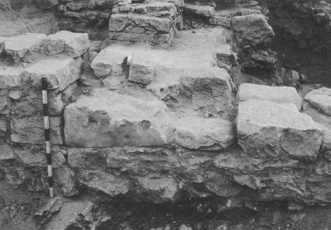 Plate 18b
Blocked doorway in north wall of L 161, phase 2 of LB II
Kelso et al. (1968) - Pl. 105c Middle Bronze
II gateway overlying east wall of the MB I Temple from Kelso et al. (1968)
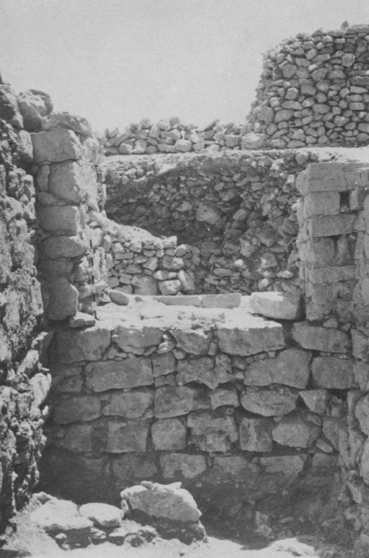 Plate 105c
Middle Bronze II gateway, looking east from the passageway after the floor had been excavated. The east wall of the MB I temple with its blocked doorway lies immediately below the gateway
Kelso et al. (1968) - Pl. 106a MB II Northwest city
overlying MB I Temple walls from Kelso et al. (1968)
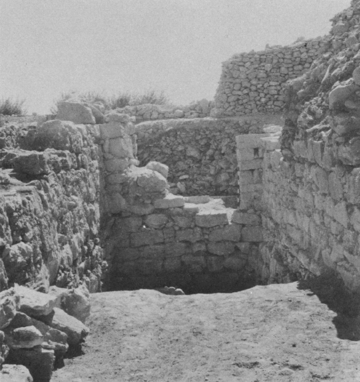 Plate 106a
Northwest city gate above; temple walls immediately below. Huwar floor of gateway in foreground.
Kelso et al. (1968) - Pl. 106b South wall of
MB I Temple from Kelso et al. (1968)
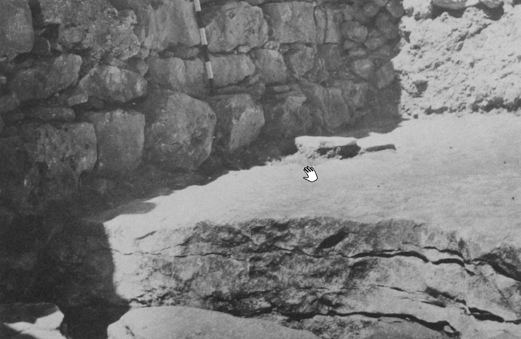 Plate 106b
Section of high place rock ledge with south wall of temple and some paving stones of temple floor above the ledge
Kelso et al. (1968) - Pl. 108a South wall of
MB I Temple beneath south wall of MB II city gate from Kelso et al. (1968)
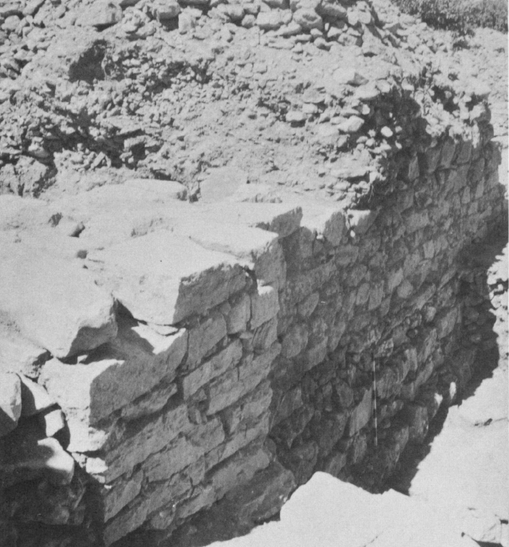 Plate 108a
Temple above the high place; south wall oftemple below (with meter stick) and south wall of city gate above. The latter is laid directly on the former.
Kelso et al. (1968) - Pl. 108b North walls of
MB I Temple and MB II city gate from Kelso et al. (1968)
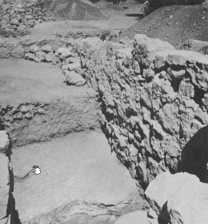 Plate 108b
High place ledge and north walls of temple and city gate. West end of the floor of the gates's north corridor is beyond the ledge.
Kelso et al. (1968) - Pl. 109b South jamb of
northwest city gate (Reconstruction) from Kelso et al. (1968)
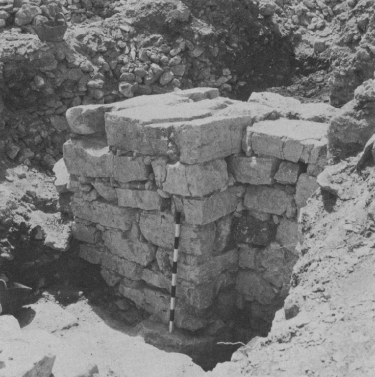 Plate 109b
South jamb of northwest city gate (Reconstruction)
Kelso et al. (1968)
- 19th century photo of
the ruins of Beitin from wikipedia
The ruins of Beitin, the site of ancient Bethel, during the 19th century
Click on image to view at a higher resolution in a new tab
Wikipedia - Francis Firth - donated to Wikimedia Commons as part of a project by the Metropolitan Museum of Art - CC0 1.0 Universal Public Domain - Pl. 14a Earthquake Collapsed
Wall of LB II phase I from Kelso et al. (1968)
Plate 14a
Wall of LB II phase I destroyed by earthquake and left as it fell.
Kelso et al. (1968) - Pl. 14b Thick Ash Layer
from destruction of LB II city in area II from Kelso et al. (1968)
Plate 14b
Over a meter of ashes in destruction of LB II city (area II) shown between the wavy black lines
Kelso et al. (1968) - Pl. 15a LB II and MB II
walls from Kelso et al. (1968)
Plate 15a
LB II walls of thin flat stones characteristic of that period. Under them with larger well-shaped stones are MB II walls. Note a drain in upper left
Click on image to open in a new tab
Kelso et al. (1968) - Pl. 15b Area I walls
(MB to Iron I) from Kelso et al. (1968)
Plate 15b
General view of Area II. Higher walls are Iron I. Note pillar construction at extreme left. Lower walls are LB over MB II. Dark areas ae bedrock on virgin soil.
Click on image to open in a new tab
Kelso et al. (1968) - Pl. 16a LB II, Iron I,
and Iron II walls in Area II from Kelso et al. (1968)
Plate 16a
General view of Area II. LB II walls in the foreground. Iron I and Iron II in background.
Click on image to open in a new tab
Kelso et al. (1968) - Pl. 16b Iron I, Iron II,
and Hellenistic walls in LB II area in area II from Kelso et al. (1968)
Plate 16b
LB II area II. Stone pavements in left center. Stone table near center of right edge. Walls in background are Iron I, Iron II, and Hellenistic
Click on image to open in a new tab
Kelso et al. (1968) - Pl. 18b Blocked doorway
from phase 2 of LB II from Kelso et al. (1968)
Plate 18b
Blocked doorway in north wall of L 161, phase 2 of LB II
Kelso et al. (1968) - Pl. 105c Middle Bronze
II gateway overlying east wall of the MB I Temple from Kelso et al. (1968)
Plate 105c
Middle Bronze II gateway, looking east from the passageway after the floor had been excavated. The east wall of the MB I temple with its blocked doorway lies immediately below the gateway
Kelso et al. (1968) - Pl. 106a MB II Northwest city
overlying MB I Temple walls from Kelso et al. (1968)
Plate 106a
Northwest city gate above; temple walls immediately below. Huwar floor of gateway in foreground.
Kelso et al. (1968) - Pl. 106b South wall of
MB I Temple from Kelso et al. (1968)
Plate 106b
Section of high place rock ledge with south wall of temple and some paving stones of temple floor above the ledge
Kelso et al. (1968) - Pl. 108a South wall of
MB I Temple beneath south wall of MB II city gate from Kelso et al. (1968)
Plate 108a
Temple above the high place; south wall oftemple below (with meter stick) and south wall of city gate above. The latter is laid directly on the former.
Kelso et al. (1968) - Pl. 108b North walls of
MB I Temple and MB II city gate from Kelso et al. (1968)
Plate 108b
High place ledge and north walls of temple and city gate. West end of the floor of the gates's north corridor is beyond the ledge.
Kelso et al. (1968) - Pl. 109b South jamb of
northwest city gate (Reconstruction) from Kelso et al. (1968)
Plate 109b
South jamb of northwest city gate (Reconstruction)
Kelso et al. (1968)
- from Fall et al. (2023)
 Table 1
Traditional and revised Early and Middle Bronze Age chronologies for the Southern Levant. (Traditional chronology based on Dever 1992; Levy 1995:fig. 3; revised chronology based on Regev et al. 2012; Fall et al. 2021; Höflmayer and Manning 2022.)
Fall et al. (2023)
| Effect | Location | Image (s) | Comments |
|---|---|---|---|
| Collapsed Walls | Area L - Middle Bronze I Temple
Plate 120 Plan of Excavated Areas 1934 through 1960 Kelso et al. (1968)
Plate 101Plan and Elevation of [Middle Bronze II] Gateway Complex and [Middle Bronze I] Cananite high place. The latter is shown in the right half of the long east-weat passageway. The nortwest city gate, with the three steps outside it, is at the east end of the Passageway. Steps also lead up from the west end of the passageway toward the south. Then the gateway turns east. The Haram area lies north of the city gate. Kelso et al. (1968) |
Pl. 105c
Plate 105c Middle Bronze II gateway, looking east from the passageway after the floor had been excavated. The east wall of the MB I temple with its blocked doorway lies immediately below the gateway Kelso et al. (1968) Pl. 106a
Plate 106aNorthwest city gate above; temple walls immediately below. Huwar floor of gateway in foreground. Kelso et al. (1968) Pl. 106b
Plate 106bSection of high place rock ledge with south wall of temple and some paving stones of temple floor above the ledge Kelso et al. (1968) Pl. 108a
Plate 108aTemple above the high place; south wall of temple below (with meter stick) and south wall of city gate above. The latter is laid directly on the former. Kelso et al. (1968) Pl. 108b
Plate 108bHigh place ledge and north walls of temple and city gate. West end of the floor of the gates's north corridor is beyond the ledge. Kelso et al. (1968) |
|
| Effect | Location | Image (s) | Comments |
|---|---|---|---|
|
Area L - Northwest Gate
Plate 120 Plan of Excavated Areas 1934 through 1960 Kelso et al. (1968)
Plate 101Plan and Elevation of [Middle Bronze II] Gateway Complex and [Middle Bronze I] Cananite high place. The latter is shown in the right half of the long east-weat passageway. The nortwest city gate, with the three steps outside it, is at the east end of the Passageway. Steps also lead up from the west end of the passageway toward the south. Then the gateway turns east. The Haram area lies north of the city gate. Kelso et al. (1968) |
Pl. 105c
Plate 105c Middle Bronze II gateway, looking east from the passageway after the floor had been excavated. The east wall of the MB I temple with its blocked doorway lies immediately below the gateway Kelso et al. (1968) Pl. 106a
Plate 106aNorthwest city gate above; temple walls immediately below. Huwar floor of gateway in foreground. Kelso et al. (1968) Pl. 108b
Plate 108bHigh place ledge and north walls of temple and city gate. West end of the floor of the gates's north corridor is beyond the ledge. Kelso et al. (1968) Pl. 109b
Plate 109bSouth jamb of northwest city gate (Reconstruction) Kelso et al. (1968) |
|
| Effect | Location | Image (s) | Comments |
|---|---|---|---|
| Collapsed Wall | Area II (aka Area B) - Locus 162
Plate 120 Plan of Excavated Areas 1934 through 1960 Kelso et al. (1968) Pl. 3
Plate 3Area II - Late Bronze Phases 1 and 2 click on image to open in a new tab Kelso et al. (1968) |
Pl. 14a
Plate 14a Wall of LB II phase I destroyed by earthquake and left as it fell. Kelso et al. (1968) Pl. 15a
Plate 15aLB II walls of thin flat stones characteristic of that period. Under them with larger well-shaped stones are MB II walls. Note a drain in upper left Click on image to open in a new tab Kelso et al. (1968) Pl. 15b
Plate 15bGeneral view of Area II. Higher walls are Iron I. Note pillar construction at extreme left. Lower walls are LB over MB II. Dark areas ae bedrock on virgin soil. Click on image to open in a new tab Kelso et al. (1968) Pl. 16a
Plate 16aGeneral view of Area II. LB II walls in the foreground. Iron I and Iron II in background. Click on image to open in a new tab Kelso et al. (1968) Pl. 16b
Plate 16bLB II area II. Stone pavements in left center. Stone table near center of right edge. Walls in background are Iron I, Iron II, and Hellenistic Click on image to open in a new tab Kelso et al. (1968) |
|
| Effect | Location | Image (s) | Comments |
|---|---|---|---|
| Collapsed Wall | Area H
Plate 120 Plan of Excavated Areas 1934 through 1960 Kelso et al. (1968)  Plate 120
Area H closeup Plan of Excavated Areas 1934 through 1960 Kelso et al. (1968) |
Plate 94b Madafeh area click on image to open in a new tab Kelso et al. (1968) |
|
- Modified by JW from Plate 3 from Kelso et al. (1968)
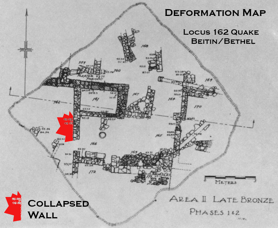 Deformation Map
Modified by JW from Plate 3 from Kelso et al. (1968)
-
Earthquake Archeological Effects chart
of Rodríguez-Pascua et al (2013: 221-224)
 Earthquake Archeological Effects (EAE)
Rodríguez-Pascua et al (2013: 221-224)
| Effect | Location | Image (s) | Comments | Intensity |
|---|---|---|---|---|
| Collapsed Walls | Area L - Middle Bronze I Temple
Plate 120 Plan of Excavated Areas 1934 through 1960 Kelso et al. (1968)
Plate 101Plan and Elevation of [Middle Bronze II] Gateway Complex and [Middle Bronze I] Cananite high place. The latter is shown in the right half of the long east-weat passageway. The nortwest city gate, with the three steps outside it, is at the east end of the Passageway. Steps also lead up from the west end of the passageway toward the south. Then the gateway turns east. The Haram area lies north of the city gate. Kelso et al. (1968) |
Pl. 105c
Plate 105c Middle Bronze II gateway, looking east from the passageway after the floor had been excavated. The east wall of the MB I temple with its blocked doorway lies immediately below the gateway Kelso et al. (1968) Pl. 106a
Plate 106aNorthwest city gate above; temple walls immediately below. Huwar floor of gateway in foreground. Kelso et al. (1968) Pl. 106b
Plate 106bSection of high place rock ledge with south wall of temple and some paving stones of temple floor above the ledge Kelso et al. (1968) Pl. 108a
Plate 108aTemple above the high place; south wall of temple below (with meter stick) and south wall of city gate above. The latter is laid directly on the former. Kelso et al. (1968) Pl. 108b
Plate 108bHigh place ledge and north walls of temple and city gate. West end of the floor of the gates's north corridor is beyond the ledge. Kelso et al. (1968) |
|
VIII+ |
-
Earthquake Archeological Effects chart
of Rodríguez-Pascua et al (2013: 221-224)
Earthquake Archeological Effects (EAE)
Rodríguez-Pascua et al (2013: 221-224)
| Effect | Location | Image (s) | Comments | Intensity |
|---|---|---|---|---|
|
Area L - Northwest Gate
Plate 120 Plan of Excavated Areas 1934 through 1960 Kelso et al. (1968)
Plate 101Plan and Elevation of [Middle Bronze II] Gateway Complex and [Middle Bronze I] Cananite high place. The latter is shown in the right half of the long east-weat passageway. The nortwest city gate, with the three steps outside it, is at the east end of the Passageway. Steps also lead up from the west end of the passageway toward the south. Then the gateway turns east. The Haram area lies north of the city gate. Kelso et al. (1968) |
Pl. 105c
Plate 105c Middle Bronze II gateway, looking east from the passageway after the floor had been excavated. The east wall of the MB I temple with its blocked doorway lies immediately below the gateway Kelso et al. (1968) Pl. 106a
Plate 106aNorthwest city gate above; temple walls immediately below. Huwar floor of gateway in foreground. Kelso et al. (1968) Pl. 108b
Plate 108bHigh place ledge and north walls of temple and city gate. West end of the floor of the gates's north corridor is beyond the ledge. Kelso et al. (1968) Pl. 109b
Plate 109bSouth jamb of northwest city gate (Reconstruction) Kelso et al. (1968) |
|
|
-
Earthquake Archeological Effects chart
of Rodríguez-Pascua et al (2013: 221-224)
Earthquake Archeological Effects (EAE)
Rodríguez-Pascua et al (2013: 221-224)
| Effect | Location | Image (s) | Comments | Intensity |
|---|---|---|---|---|
| Collapsed Wall | Area II (aka Area B) - Locus 162
Plate 120 Plan of Excavated Areas 1934 through 1960 Kelso et al. (1968) Pl. 3
Plate 3Area II - Late Bronze Phases 1 and 2 click on image to open in a new tab Kelso et al. (1968) |
Pl. 14a
Plate 14a Wall of LB II phase I destroyed by earthquake and left as it fell. Kelso et al. (1968) Pl. 15a
Plate 15aLB II walls of thin flat stones characteristic of that period. Under them with larger well-shaped stones are MB II walls. Note a drain in upper left Click on image to open in a new tab Kelso et al. (1968) Pl. 15b
Plate 15bGeneral view of Area II. Higher walls are Iron I. Note pillar construction at extreme left. Lower walls are LB over MB II. Dark areas ae bedrock on virgin soil. Click on image to open in a new tab Kelso et al. (1968) Pl. 16a
Plate 16aGeneral view of Area II. LB II walls in the foreground. Iron I and Iron II in background. Click on image to open in a new tab Kelso et al. (1968) Pl. 16b
Plate 16bLB II area II. Stone pavements in left center. Stone table near center of right edge. Walls in background are Iron I, Iron II, and Hellenistic Click on image to open in a new tab Kelso et al. (1968) |
|
VIII+ |
-
Earthquake Archeological Effects chart
of Rodríguez-Pascua et al (2013: 221-224)
Earthquake Archeological Effects (EAE)
Rodríguez-Pascua et al (2013: 221-224)
| Effect | Location | Image (s) | Comments | Intensity |
|---|---|---|---|---|
| Collapsed Wall | Area H
Plate 120 Plan of Excavated Areas 1934 through 1960 Kelso et al. (1968)
Plate 120Area H closeup Plan of Excavated Areas 1934 through 1960 Kelso et al. (1968) |
Plate 94b Madafeh area click on image to open in a new tab Kelso et al. (1968) |
|
VIII+ |