IUI (Interuniversity Institute for Marine Sciences) Buried Reefs
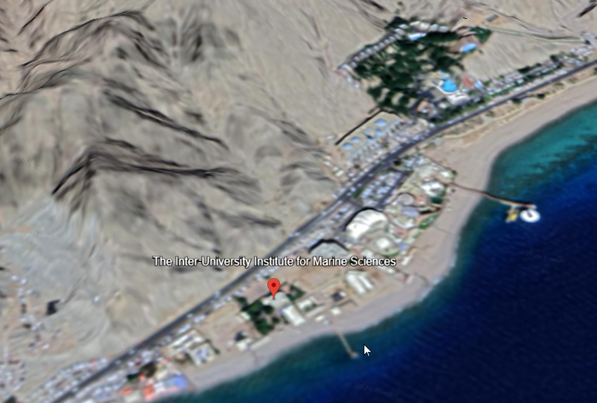 IUI Site
click on image to explore this site on a new tab in Google Earth
Maps, Aerial Views, Illustrations, Logs, and Chronology
Maps
Location Map
- from Shaked et al. (2011)
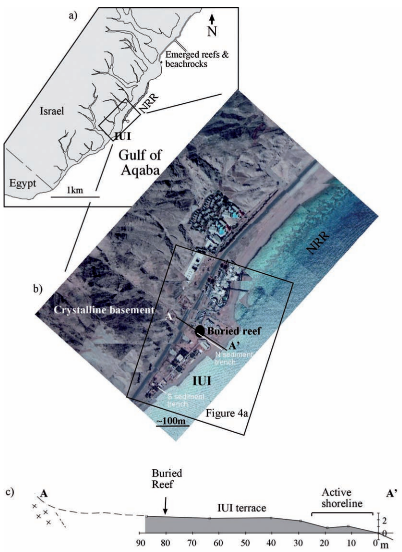 Figure 3
The IUI shoreline: a) Outline of the shore near the IUI showing the drainage patterns, location of the IUI and the modern nature reserve reef (NRR), and the emerged reefs that constrain the Holocene sea level (Fig. 2). b) Aerial photo of the IUI beach with the location of the construction and exploration pits and the boreholes that exposed the buried reef marked as a black circle, sediment trenches are shown as white lines. The boxes mark the areas shown in Figs. 4a and 8. c) Topographic profile across the IUI terrace at its widest part (A–A’). Grey marks the length of the northern sediment trench.
Click on Image to open in a new tab
Shaked et al. (2011)
Geomorphic map and Cross-Section
- from Shaked et al. (2011)
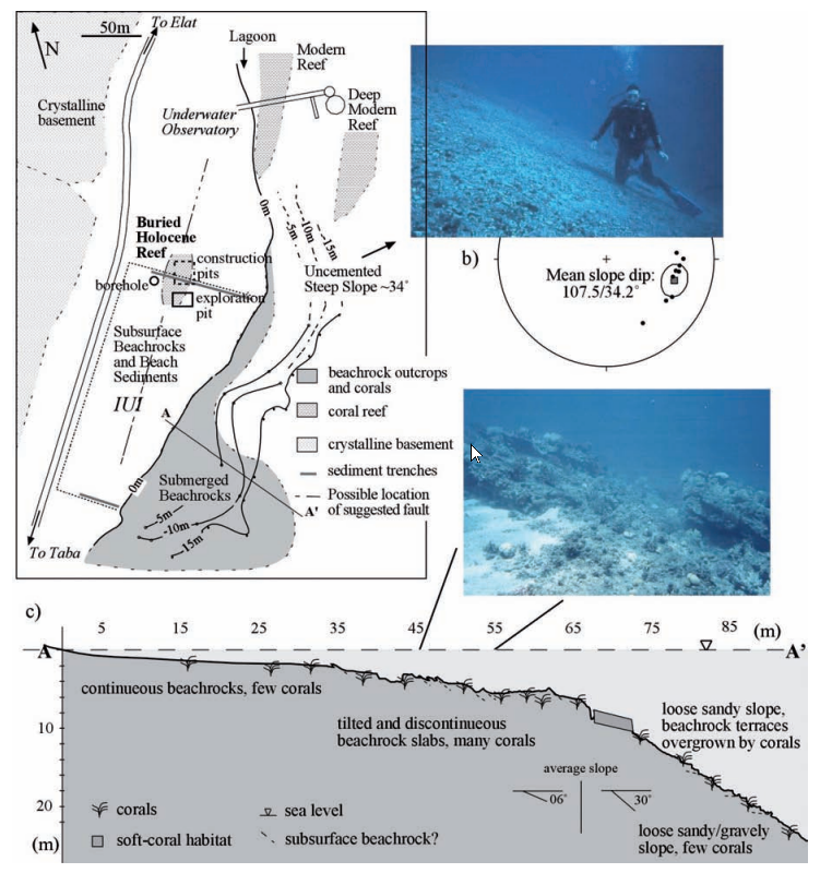 Figure 4
a) Geomorphic map of the shallow slope off-shore from the IUI. b) The north-facing slope of unconsolidated material, its inclination >30˚. Note the air bubbles above the diver, indicating vertical. c) A cross section off the south-facing slope and photo from the shallow part showing tilted “beachrock” strips overgrown by corals (a & c are modified from Shaked et al., 2002).
Click on Image to open in a new tab
Shaked et al. (2011)
Aerial Views
Normal Size
- IUI Site in Google Earth
IUI Site
click on image to explore this site on a new tab in Google Earth
Magnified
- IUI Site in Google Earth
IUI Site
click on image to explore this site on a new tab in Google Earth
Illustration of Reconstructed Events
- from Shaked et al. (2011)
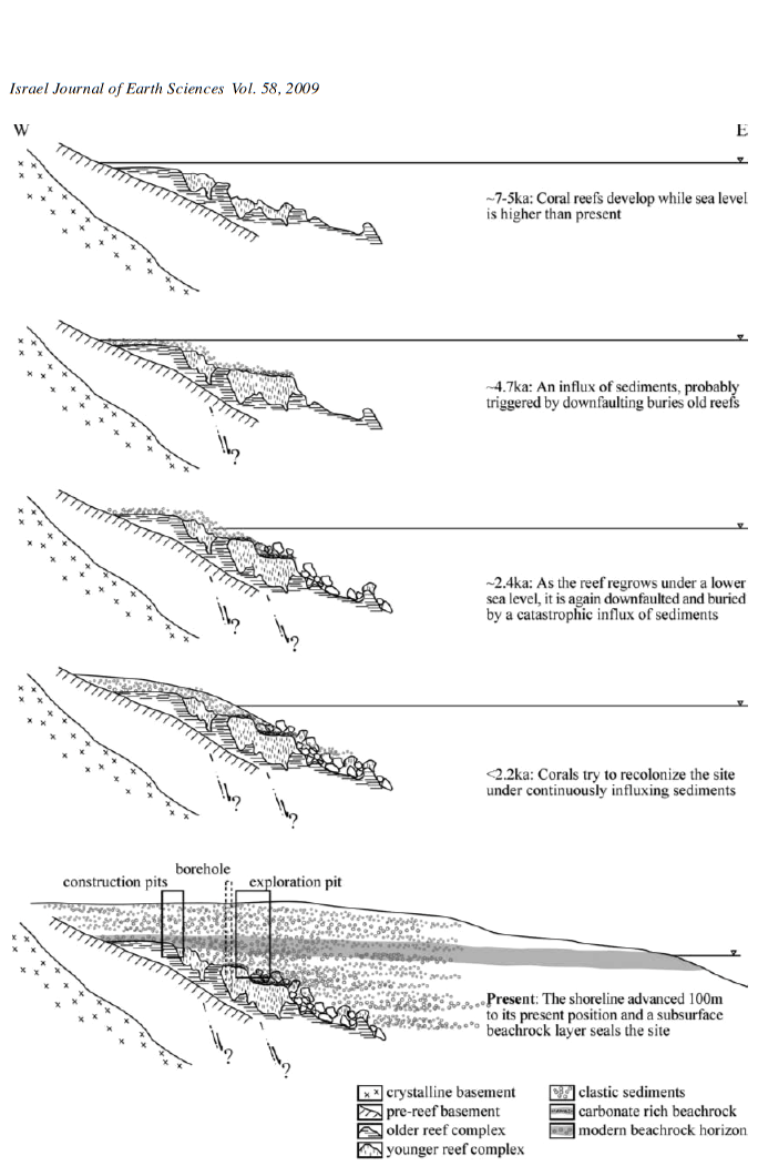 Figure 9
Illustration (not to scale) of reconstructed events at the IUI buried reef site. Boxes at present-day section denote the stratigraphy found at construction pits and the exploration pit. The dashed box of the borehole stratigraphy is projected onto the section and only shows the older reef beneath lagoon sediments.
Click on Image to open in a new tab
Shaked et al. (2011)
Stratigraphic Log
- from Shaked et al. (2011)
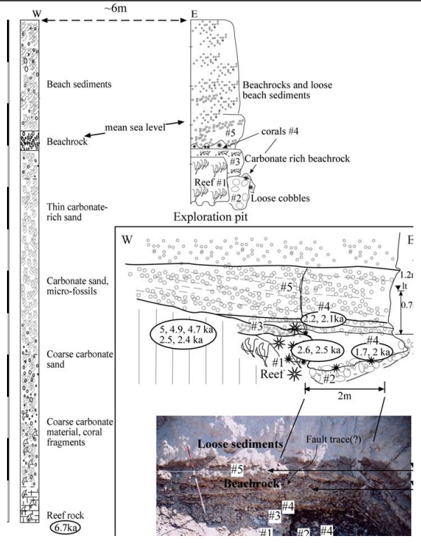 Figure 6
Stratigraphy of the IUI buried reef: a) Log of the borehole (left) and, ~6 m to the east, stratigraphic section at the research pit. b) Cross section (north wall) and photograph of the buried reef at the IUI research pit. lt—low tide mark; ht—high tide mark.
Click on Image to open in a new tab
Shaked et al. (2011)
Chronology
Age-Depth Plot
- from Shaked et al. (2011)
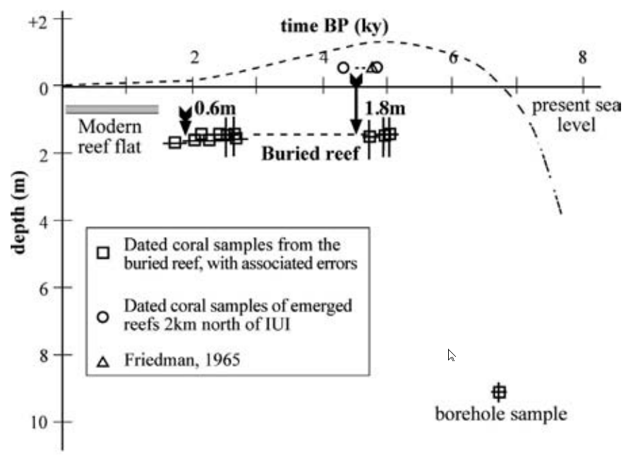 Figure 7
Dated coral samples from the buried reef
Click on Image to open in a new tab
Shaked et al. (2011)
Sea Level Curve
- from Shaked et al. (2011)
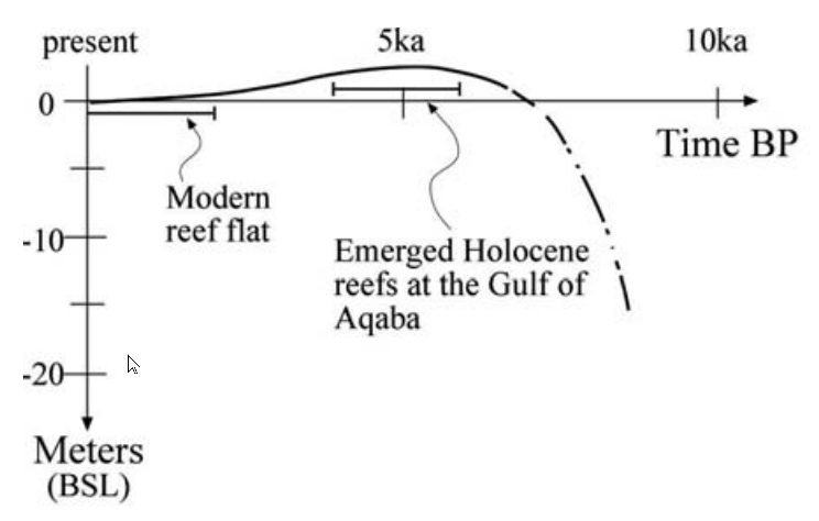 Figure 2
The Holocene sea level curve for the GEA, constrained by emerged reefs surrounding the gulf (Shaked et al., 2004)
Click on Image to open in a new tab
Shaked et al. (2011)
Table of Dated coral samples from the buried reef
- from Shaked et al. (2011)
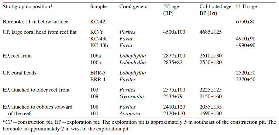 Table 2
Dated coral samples from the buried reef
Click on Image to open in a new tab
Shaked et al. (2011)
Event A - ~2750 BCE
Discussion
Shaked et al. (2011)
Abstract
Examination of fossil reefs in 3-D reveals a series of tectonic, climatic, and biological processes in the northwestern corner of the Gulf of Elat-Aqaba (GEA). We excavated a reef buried beneath clastic beach sediments, examined its morphology, and collected coral samples in situ. The reef is preserved in pristine condition due to the sedimentary cover and its position below sea level. Coastal geomorphology and sediments are combined with evidence from the buried reef to describe the late Holocene evolution of this stretch of the coast that is shaped by activity of the Dead Sea Transform system. Radiocarbon and uranium series ages of coral samples from the reef set the temporal framework for events. At least two down-faulting events are inferred from the buried reef, at ~4.7 ka and ~2.4 ka. Following the second event the reef was completely buried and fossilized, and the shoreline propagated 100 m eastwards into the sea. Hence the present shoreline was shaped by recurrent tectonic displacements followed by redistribution of sediments along the coast.
Introduction
Coral reefs are complex systems with a three- dimensional morphology, the understanding of which can greatly refine relative sea-level interpretations. In uplifting regions, fossil coral reefs are studied in outcrops (e.g., Chappell, 1974), but where reefs are not exposed, as in subsiding regions, reefs are commonly studied by drilling sample cores (e.g., Fairbanks, 1989). Here we study a fossil reef complex on the subsiding northwestern shore of the Gulf of Elat-Aqaba by digging a wide exploration pit into the sediments that bury it. We expose the reef morphology and use the elevation of the reef-flat and reef sedimentary section to reconstruct late Holocene tectonic/sedimentary events.
The Gulf of Elat-Aqaba (GEA) is a deep, narrow tectonic depression in the southern part of the Dead Sea Transform system (DST) (Fig. 1) (Hall and Ben-Avraham, 1978; Garfunkel et al., 2000). In addition to left-lateral motion of the DST, the depression in GEA embodies recurrent vertical displacements. Such vertical displacements formed sequences of uplifted Pleistocene coral reefs on its northeastern and southwestern shores (Al-Rifaiy and Cherif, 1988; Gvirtzman et al., 1992) and submerged reefs on the northwestern end of the Gulf, near Elat (Shaked et al., 2004; Makovsky et al., 2008). Historic earthquake catalogues list several earthquakes around the gulf in the last two millennia (see Ambraseys, 2009, for a recent and critical compilation). On-shore evidence for historical earthquakes include paleoseismological trenching (Amit et al., 2002), ground-penetrating radar imaging (Slater and Niemi, 2003) and archaeological damage (Thomas et al., 2007). Some historical earthquakes centered at the gulf were associated with deformed sediments in the Dead Sea (Migowski et al., 2004; Agnon et al., 2006; Kagan et al., 2011). Rockfalls dated by cosmogenic isotopes and luminescence, by virtue of clustered ages, also suggest seismic events (Matmon et al., 2005).
Fossil reefs of Pleistocene age indicate that conditions suitable for the development of coral reefs prevailed at the GEA during interglacial periods (Al-Rifaiy and Cherif, 1988; Klein et al., 1990; Gvirtzman et al., 1992; El-Asmar, 1997). Following the end of the last glacial period global sea level rose rapidly, until ~7–6 ka (Fairbanks, 1989; Fleming et al., 1998). Mid-Holocene sea level at the GEA was above the present level, having a Holocene maximum of ~1.2 m some 5,000 years ago (Fig. 2) (Shaked et al., 2004). The Holocene high stand was sufficiently long to form reef terraces, subsequently exposed and often capped by beachrock as the sea gradually dropped to its present level (Shaked et al., 2004, 2005). Emerged fossil Holocene reefs have been documented along the GEA on the coasts of southern Sinai (SW), Aqaba (NE), and near Elat (NW) (e.g., Friedman, 1965; Al-Rifaiy and Cherif, 1988; Gvirtzman et al., 1992; Shaked et al., 2004) (Fig. 1). These emerged reefs and the modern reef flat of the Elat fringing reef provide baselines to which elevations of displaced reefs may be compared. Evaluating the role of vertical displacements in shaping the northwestern coast of the GEA during the late Holocene was the object of this study. The buried reef examined here reveals at least two events of vertical displacement. These events dictated the pattern of sediment deposition along this coast.
Methods
We study the geomorphology of the coast at the Interuniversity Institute for Marine Sciences (IUI), approximately 7 km south of Elat, on land and at sea through aerial photos, topographic and bathymetric surveys, and SCUBA observations. We elaborate the sedimentary section of the IUI terrace at four locales shown in Fig. 3:
1) Two shallow trenches dug perpendicular to the shore at the southern and northern ends of the IUI respectively;
2) A 5-m-deep pit dug 80 m west of the shoreline at the northern end of the IUI to expose the buried reef and to enable in-situ sampling of corals and beachrocks;
3) Two boreholes drilled 90 and 95 m away from the shore at the northern end of the IUI, respectively;
4) Construction pits at the northern end of the IUI from which coral samples were collected.
We document lithologies and analyze relative abundances of clasts at drainage basin outlets adjacent to the IUI and on nearby beaches, to identify sources.
Shallow-water coral samples from the buried reef were examined under a microscope and selected for mineralogical study using optical microscopy and Fourier Transform Infra Red Spectroscopy (FTIR). Pristine aragonite samples were dated by the radiocarbon and U-series methods. Preparation of coral samples for dating included (1) washing in an ultrasonic tank of distilled water and a brief wash of radiocarbon samples with 5% HCl, then crushing samples into ~1–2-mm fragments; (2) examination under a microscope and hand picking and discarding of discolored or encrusted fragments; (3) washing the remaining fragments again in an ultrasonic tank of distilled water.
We determined AMS 14C ages at the NSF Accelerator Mass Spectrometry Laboratory at the University of Arizona. We calibrated ages in calendar years with the OxCal v3.5 code of Ramsey (2001) using the marine calibration curve of Stuiver et al. (1998) that incorporates a 402-year ocean residence time (OxCal: http://www.rlaha.ox.ac.uk/orau).
U-series dating (TIMS) was carried out at the Max-Planck- Institut für Chemie in Mainz (Germany).
Geomorphology Of The IUI Coast
The IUI coast is characterized by a low, flat, fan-like sedimentary terrace extending ~150 m seaward at its widest point and rising 2–3 m above sea level (Fig. 3). Beachrock crops out along the southern part of the IUI shoreline. The active shoreline consists of a beach slope, a beach ridge and back-trough, and a low storm- generated rise some 25 m from the waterline. At its western end, the coastal terrace of the IUI rests against steep crystalline basement hills.
Underwater, the slope is divided into two regions corresponding to the northern and southern sides of the roughly triangular IUI coast (Fig. 4). The northern slope is steep (>30°) and comprises unconsolidated pebbles of varying sizes (0.5–5 cm). The slope is unstable and does not support coral colonization and growth. North of the IUI, the Elat nature reserve fringing reef (NRR) extends northwards ~1 km parallel to the shoreline (Fig. 3a). The NRR terminates as it reaches the unstable northern slope of the IUI (Figs. 3b, 4a). In contrast to the northern IUI slope, the southern slope descends gently (~6°) to a depth of 7–8 m, and is paved by eroding conglomerate strips dipping eastward (Fig. 4b,c). These are similar in appearance to the beachrocks outcropping at the shoreline, and are partly overgrown by corals. A morphologic break in the slope occurs at 7–8 m depth and the slope becomes steep, ~30°, dropping to a depth of 40 m. Along the steep slope in the southern part of the IUI sedimentary terrace, beachrock conglomerates outcrop to a depth of more than 20 m. These are often tilted, probably as a result of undercutting and breaking of the hard beachrock beds. A reef framework has not developed on the southern slope despite the hard seafloor that provides substrate for coral settlement, and it seems that this area is presently undergoing submarine erosion
The Buried Holocene Reef At The IUI Terrace
The material taken out of pit holes dug at the IUI terrace includes well-preserved coral heads, some with a flat-top morphology (Fig. 5). The perfectly preserved corals are not overgrown by marine organisms, and not cemented/infilled by secondary minerals. Some samples, however, contained crystalline rock fragments that penetrated into the voids of the coral structure. These distinct features suggest a sudden influx of clastic sediments that buried the corals while still alive, and preserved them in perfect form from later overgrowth, erosion, bioerosion, or alteration that would otherwise occur rapidly underwater.
Boreholes drilled near the pits, 90 and 95 m west of the waterline, revealed a clastic section to a depth of about 11 m (Fig. 6a). The section comprises corals 11 m below the surface covered by 8 m of fine lagoonal carbonate sand and bioclasts, a nearly 1-m-thick indurated layer where pebbles of crystalline rocks are cemented into beachrock, and an upper 2–3 m of loose, mostly crystalline, pebbles.
Geological section and stratigraphy
An exploration pit was dug into the IUI terrace 80–90 m west of the shoreline, where the ground surface rises 2–3 m above sea level. The pit reaches nearly 2 m below the present mean sea level. The stratigraphic section revealed was divided into the following five stratigraphic units (Fig. 6):
1) Fossil reef: On the western part of the pit is a well-developed fossil reef with a distinct reef-flat. The top of the reef-flat is 0.6 m lower than the average elevation of the modern reef-flat at Elat. The corals in this reef are very well preserved (Fig. 5) and are partially cemented by aragonite crystals and micritic mud along with coralline algae, mollusks, boring worms and other reef-dwelling organisms. The exposed section comprises a large, meters wide, branching specimen of the coral Lobophyllia together with various other smaller corals, with mud and clasts infilling the cavities.
2) Loose cobbles: A pile of large (10–30 cm) crystalline cobbles lies seaward of the reef structure, leaning against the “fore-reef” and filling the topography created by it (at least 1 m high). The cobbles are not spherical but most angles are rounded, attesting to limited transport but possible reworking in an active beach environment. Some of the cobbles are overgrown by small, perfectly preserved branchy corals (Fig. 5c).
3) Carbonate cemented conglomerate: The reef flat is covered by a thin (~0.3 m) light-colored layer of small clasts of crystalline provenance, up to 2 cm in size, embedded in a matrix of carbonate mud (~50%). This carbonate rich unit fills cavities in the fossil reef, and at the front of the reef structure it created a substrate for settlement by younger corals. The unit forms an indurated horizon (0.5–0.7 m thick) that extends south where the reef structure curves to the west (Fig. 5e). The carbonate rich unit is not found east of the reef.
4) Juvenile corals: Some small corals were found in growth position on the thin indurated layer of Unit #3 and over some of the cobbles of Unit #2. These “juvenile” corals of various species were buried before developing a reef framework.
5) Cover conglomerate: The reef complex is overlain by a >4 m thick clastic section that covers the site and rises above the present sea level. This unit comprises gently inclined clastic sets with clasts of varying size and lithologies. Most of the clasts are rounded pebbles (between 0.5 and 10 cm) of crystalline material, but limestone, chert, and marine bio-clasts are present as well. Within this unit, at the present intertidal zone (~0.7 m above the fossil reef-flat), the sediments are cemented to form an indurated beachrock layer ~1 m thick. These sediments differ from the cobbles of Unit #2 mainly in size, but are also smoother (i.e., “pebbly”) and have a more diverse composition attesting to greater transport and reworking along the shores.
Corals and coral ages
We collected a variety of corals from the buried reef (Table 1). Some of the corals could not be traced directly to their in-situ location because they were recovered during digging under the water table, whereas others were collected from their growth position after water was pumped out of the exploration pit. In spite of the small area of the pit exposure, the diversity of coral species collected is similar to the species diversity of stony corals of the modern reefs in shallow waters of the region (Loya and Slobodkin, 1971; Mergner, 1971; Shaked and Genin, 2011).
Ten corals were sampled from the different stratigraphic units at the site specifically for age determination by the 14C and U-Th methods (Table 2). Samples dated are composed of >95% pristine aragonite; secondary aragonite filling comprises less than 5% of the pore volume. The ages and elevation of the dated corals are presented in Fig. 7 and Table 2.
Two distinct age clusters appear within the buried reef, one at ~5 ka, and the second <3 ka. The older ages were derived from large, well-preserved corals that were collected from nearby construction digs. Other corals from the same locations and all the corals from the IUI exploration pit yielded ages younger than 3 ka. A single date from the coral encountered 11 m deep in the borehole (8 m below sea level) is older than all others, 6.7 ka.
The 6.7 ka coral from the borehole constrains the relative sea level only to within several meters, but it indicates that by ~7 ka the sea level was at least higher than –8 m, and that the environmental conditions at the time were favorable for coral growth.
While insufficient sampling may explain the apparent clustering around ~5 ka and <3 ka, the pristine state of the coral skeletons (Fig. 5) suggests a sudden sediment influx event that buried ~5 ka corals. The corals were thus protected from later overgrowth or erosion. The youngest corals (Unit #1) underneath the clastic Unit #3 are ~2.4 ka, and the corals above it (Unit #4) are 2.2–1.7 ka.
The Sediments Above The Reef Complex
We studied the sediments overlying the buried Holocene reef complex in two shore-perpendicular trenches. The trenches revealed a cross-bedded clastic section of beach sediments containing grains of the following lithologies: Precambrian crystalline rocks, Cretaceous carbonates and cherts, and Quaternary marine fragments. The top of a continuous beachrock horizon is exposed along the bottom of the trenches. Cross cutting relations between depositional structures and the indurated beachrock layer indicate that cementation takes place within the sedimentary pile at the present intertidal zone (Cohen et al., 2000; Shaked et al., 2002). The sediments underneath the indurated layer were exposed at the IUI pit. They contain lithologies similar to the overlying sediments and to the sediments at the active beaches in the vicinity (Table 3). These are chiefly crystalline clasts (granite, gneiss, schist, and rhyolite), with fewer clasts derived from Mesozoic sedimentary rocks (carbonates, and cherts), and Quaternary marine bio-fragments. Deposition of these sediments is clearly younger than the youngest underlying corals, i.e. < 1.7 ka.
A comparison between the lithic composition of sediments at the active beaches and at drainage outlets in this area (Figure 8, Table 3) shows that the beaches have a uniform composition with granite and gneiss clasts comprising less than 60% of the total assemblage. The local drainage basins on the other hand supply a clastic assemblage containing more than 75% granite and gneiss that are the chief lithologies exposed near this stretch of the coast. This suggests that sediments are transported along the shore, in quantities sufficient to change the locally dominant granite and gneiss assemblage. A most likely source for the abundant marine sedimentary clasts on the beaches is Wadi Taba, south of the IUI, that has a large drainage basin with widespread Mesozoic outcrops (Figure 8).
Discussion
Introduction
Coral reefs are biological systems that may comprise three regimes that can be distinguished by their sedimentary footprint:
- lagoon/backreef regime characterized by thin, mostly carbonate, sediments and sporadic patches of corals and reef-rock
- a reef structure of hard carbonate rock, where the main frame-builders are hermatipic corals
- fore-reef slope comprising mostly corals and coral rubble
• Coral reefs along the modern shores of Elat began to settle on the sea floor at shallow depths at least 7 ka, and gradually reef flats were formed according to the prevailing sea level. The shoreline at the IUI was at the time some 100 m west of its present position. Our indicator for this phase is the coral found at a depth of 8 m in the borehole west of the buried reef. The coral is overlain by lagoon sediments and it seems that it was never part of a reef structure. This coral may represent a first-settler or part of a lagoon-back reef system that is coupled with the buried reef revealed by our excavation pit. Reefs and sediments began to accumulate ever since sea level inundated this site. Although we cannot rule out a fault separating the reef from the coral, we have no indication that such a fault exists, and the field relations are well explained without one.
• At ~4.7 ka an influx of clastic sediments covers the IUI reef, preserving its corals in pristine condition. This event was perhaps triggered by down-faulting at the site, since the reef-flat of this unit is lower than its coeval counterparts at other locations along the gulf. This reef could have been separated from the shore by a narrow and shallow lagoon (as is indicated by the thin sediments found at the borehole just west of the pit) that would have limited the amount of sediments brought to the site. The covering sediments are most likely derived from the adjacent shore/beach and thus reflect the composition of the nearby crystalline hills—but are not derived directly from them.
• Corals resettled at the site and a younger reef flat was formed ~3 ka. At 2.4 ka, growth was once more interrupted by an influx of sediments that compose Unit #3 exposed at the exploration pit. This event may also be related to down-faulting at the site: the buried <3 ka reef flat is 0.6 m lower than the level of the modern reef flats, while sea level at this time is virtually similar to modern. Low wave energy and overall uniform conditions along this stretch of the coast make the reef flats in this region useful level-markers. Considering the time it takes to form a reef flat—on the order of thousands of years— and the fact that limiting factors on table elevation (such as tidal range and storms) are similar at this part of the gulf, it is likely, although not beyond all doubt, that a measurable elevation difference between adjacent reef flats has an underlying tectonic cause. Unit #2 at the pit may also be associated with the same event.
• A short phase of coral resettlement follows; small corals (Unit #4) overgrow clastic units #2 and #3. Coral resettlement in this phase was apparently short and may have occurred under conditions of continuous sediment influx, as all corals are small and a reef framework was not formed.
• Sediments bury the site completely, preserving the corals of Unit #4. Large quantities of beach sediments are continuously transported to the site along the shore. The shoreline migrates ~100 m seaward and an indurated beachrock horizon forms within the beach sediments. While this could represent a drop in sea level, such a change is not recognized elsewhere at this period. It is more likely that alongshore transport reshapes this part of the shoreline following changes to its geometry.
Sea level
Fossil Holocene coral reefs 6–4.5 kyr old are abundant around the gulf, 1.2 m higher than the elevation of the modern living reef flats (the latter lying ~0.6 m below mean present sea level), indicating a sea level drop by that amount (Shaked et al., 2004). This sea level pattern provides the framework for interpretation of the data from the buried reef. When sea level dropped, the now-emerged Holocene reefs were eroded and at many locations covered by clastic sediments that pushed the shoreline seaward (to the southeast). The emerged reefs died, but at some locations the reef continued to grow seaward according to the new sea level (Gvirtzman et al., 1992). The buried reef at the IUI does not display marks of erosion, indicating that it was never exposed above the sea level.
Tectonics
Downward displacement of at least 0.6 m occurred at the IUI site sometime later than 2.4 ka (the youngest age of the buried reef flat). This may have triggered influx of sediments forming Unit #3, and if so it is bounded by the corals of Unit #4, to be older than 2.2 ka. Since the corals of Unit #4 do not accurately constrain sea level, this event may also be younger than 2.2 ka, but that would call for a different explanation for the sedimentary influx, and an alternative explanation is not apparent. In any case, down-faulting must have predated the development of the beachrock horizon within the covering sediments, since that horizon is continuous over the site.
An earlier down-faulting event may have displaced the 5 ka reef from the elevation of 1.2 m above present sea level. Unfortunately, data regarding the accurate elevation of 5 ka reef structure at the IUI site are insufficient, and further excavations might shed light on this stage. Lagoonal sediments overlying a 6.7 ka coral found in boreholes west of the exploration pit indicate the presence of reefs at the site at that time. The discontinuous character of the reefs at this site, which was colonized by corals since ~7 ka, suggests repeated events that hinder the development of a mature reef (Shaked et al., 2005).
Closely spaced active marginal faults with varying vertical displacements are recognized on land north of the IUI (Garfunkel, 1970; Amit et al., 2002). These compose the western rift margin immediately north of the GEA. We suggest a similar distribution of shallow faults along the northwestern coast of the GEA, some of which are found off shore (Ben-Avraham and Tibor, 1993; Makovsky et al., 2008) and some that affect the sedimentary coastal terrace at the IUI.
Covering sediments
Instantaneous burial of the corals at this site is likely related to down-faulting of the margin. Sediments must have fluxed in abruptly while the corals were still living, perhaps backwashed from land to fill the topography created by down-faulting. Sediments deposited in these events were sufficient to bury and seal the down-faulted site from subsequent erosion. Following these events the shoreline advanced seaward by a hundred meters, creating the IUI coastal terrace, probably through long-shore transport as a new coastal equilibrium is created. It is unlikely that the present fluvial system draining to the shore of the IUI can produce such quantities of sediments over a short period of time. Comparison of lithologies found at the IUI beach with those of adjacent beaches and adjacent catchment basins leads to two conclusions (Fig. 8):
1) The lithic composition of adjacent drainage systems excludes fluvial transport from being the major source of sediments composing the IUI beach terrace.
2) The bulk of the sediments were apparently transported to the IUI beach along the shore, most probably during high-energy southern storm events. Prevailing northern waves or currents at the northwestern GEA are not strong enough to transport pebble-size clasts due to the short fetch; by contrast, severe southern storms that occur several times a decade are observed to transport large quantities of sediments. The Wadi Taba outlet (Fig. 8), 2 km south of the IUI, is a likely source for the sediments found at the IUI beach. The underwater morphology of the IUI, the depositional structures within the IUI coastal sediments, and the morphology of the coast support these conclusions.
Cementation of the sediments into an indurated beachrock horizon at the intertidal elevation commenced following deposition of the sediments at the IUI.
The IUI shoreline
Shoreline structure is determined by the dynamics of buildup and destruction processes controlled by the local conditions of sediment supply, sediment transport (winds, currents, and fluvial systems) and cementation, tectonics, and sea level changes. Abrupt tectonic perturbations near the shoreline may result in redistribution of sediments along the coast. The rapid advance of the IUI shoreline in the past two thousand years seems to have been triggered by earthquakes: while down-faulting west of the reef perhaps pushed the shoreline briefly to the west, subsequent— and perhaps immediate—sediment transport piled beach sediments over the down-faulted reef table.
Conclusions
Reef stratigraphy and direct sampling of in-situ corals from a buried reef on the northwestern shore of the Gulf of Elat-Aqaba reveal a complex tectonic and sedimentary history. Perfectly preserved fossil corals and coral structures have prompted a careful elevation survey for comparison with the adjacent modern reef flat and fossil emerged reefs. Considered together, coral ages and levels indicate down-faulting and related coral burial at the site. At least two such events appear to have occurred in the past 5,000 years, displacing the site vertically a total of 1.8 m. Following the last event, ~2.3 ka, redistribution of beach sediments along the coast pushed the shoreline at the IUI approximately 100 m seaward.
Event B - ~450 BCE
Discussion
References