Tell Keisan
 Tell Keisan aerial view facing northwest
Tel Keisan Excavation Website - University of Chicago
| Transliterated Name | Source | Name |
|---|---|---|
| Tell Keisan | Arabic | تل كيسان |
| Tel Kisson, Tel Kison | Hebrew | תל כיסון |
- Plate 1a Location Map
from Briend and Humbert (1980)
 Plate 1a
Puits = Well, Flueve = River
Location Map
Briend and Humbert (1980) - Plate 1b Geologic Map
from Briend and Humbert (1980)
 Plate 1b
Geologic Map
Briend and Humbert (1980) - Map of the Land of Cabul
during the Canaanite and Israelite periods from BibleWalks.com
 Map of the Land of Cabul during the Canaanite and Israelite periods
(based on Bible Mapper 3.0)
Used with permission from BibleWalks.com - Fig. 1 Map of the Plain
of Acre during the times of the Crusades from Briend and Humbert (1980)
 Fig. 1
Map of the Plain of Acre during the times of the Crusades
Briend and Humbert (1980)
- Plate 1a Location Map
from Briend and Humbert (1980)
Plate 1a
Location Map
Puits = Well, Flueve = River
Briend and Humbert (1980) - Plate 1b Geologic Map
from Briend and Humbert (1980)
Plate 1b
Geologic Map
Briend and Humbert (1980) - Map of the Land of Cabul
during the Canaanite and Israelite periods from BibleWalks.com
Map of the Land of Cabul during the Canaanite and Israelite periods
(based on Bible Mapper 3.0)
Used with permission from BibleWalks.com - Fig. 1 Map of the Plain
of Acre during the times of the Crusades from Briend and Humbert (1980)
Fig. 1
Map of the Plain of Acre during the times of the Crusades
Briend and Humbert (1980)
- Annotated Satellite Photo
of Tell Keisan and surroundings from BibleWalks.com
- Tell Keisan in Google Earth
 Tell Keisan
click on image to explore this site on a new tab in Google Earth - Tell Keisan on govmap.gov.il
 Tell Keisan
click on image to explore this site on a new tab in govmap.gov.il

- Plate 2 Map of the mound
and excavation areas from Briend and Humbert (1980)
 Plate 2
Tell Keisan: map of the mound and excavation areas
Briend and Humbert (1980) - Map of the mound
and excavation areas from Jean-Baptiste Humbert in Stern et. al. (1993 v. 3)
 Tell Keisan: map of the mound and excavation areas.
Stern et al. (1993 v. 3)
- Plate 2 Map of the mound
and excavation areas from Briend and Humbert (1980)
Plate 2
Tell Keisan: map of the mound and excavation areas
Briend and Humbert (1980) - Map of the mound
and excavation areas from Jean-Baptiste Humbert in Stern et. al. (1993 v. 3)
Tell Keisan: map of the mound and excavation areas.
Stern et al. (1993 v. 3)
- Fig. 51 Plan of
Structures of Level 9A (Area B) from Briend and Humbert (1980)
 Fig. 51
Plan of Structures of Level 9A (Area B)
Briend and Humbert (1980) - Fig. 52 Axonometric
view of Level 9A (Area B) and distribution of ceramics from Briend and Humbert (1980)
 Fig. 52
Axonometric view of level 9a (Area B), and distribution of ceramics. N.B.: The numbering of the objects is that of the plates, or failing that, the inv. no..
Briend and Humbert (1980) - Fig. 7 Axonometric
view of the "House of 11th" from Briend and Humbert (1980)
 Fig. 7
Axonometric view of the "House of 11th"
Briend and Humbert (1980)
- Fig. 51 Plan of
Structures of Level 9A (Area B) from Briend and Humbert (1980)
Fig. 51
Plan of Structures of Level 9A (Area B)
Briend and Humbert (1980) - Fig. 52 Axonometric
view of Level 9A (Area B) and distribution of ceramics from Briend and Humbert (1980)
Fig. 52
Axonometric view of level 9a (Area B), and distribution of ceramics. N.B.: The numbering of the objects is that of the plates, or failing that, the inv. no..
Briend and Humbert (1980) - Fig. 7 Axonometric
view of the "House of 11th" from Briend and Humbert (1980)
Fig. 7
Axonometric view of the "House of 11th"
Briend and Humbert (1980)
- Fig. 5 Succession
of Levels 9 to 11 in the "House of 11th" from Briend and Humbert (1980)
 Fig. 5
Succession of Levels 9 to 11 in the "House of 11th"
Briend and Humbert (1980) - Fig. 6 Section of
9A Destruction Layer (Locus 5281) from Briend and Humbert (1980)
 Fig. 6
Section of Destruction Layer 5281 (Level 9A)
Briend and Humbert (1980) - Plate 120a Destruction
layer sealing Locus 501(Level 9a) from Briend and Humbert (1980)
 Plate 120a
The destruction layer sealing Locus 501(Level 9a)
Briend and Humbert (1980) - Plate 120b brick wall
layer before removal from Briend and Humbert (1980)
 Plate 120b
The brick wall layer before removal
Briend and Humbert (1980) - Plate 120c Plan View
of brick wall layer from Briend and Humbert (1980)
 Plate 120c
The brick wall layer: plan view.
Briend and Humbert (1980) - Plate 120d Section of
the destruction layer (see fig. 6) from Briend and Humbert (1980)
 Plate 120d
Section of the destruction layer (see fig. 6)
Briend and Humbert (1980) - Plate 120e The position
of the racks shows direction of fall of the bricks from Briend and Humbert (1980)
 Plate 120e
The position of the racks shows the direction of the fall of the bricks (from left to right)
Briend and Humbert (1980) - Plate 121a Jar bases
stuck in the ground of Locus 606 (level 9a) from Briend and Humbert (1980)
 Plate 121a
Jar bases stuck in the ground of Locus 606 (level 9a)
Briend and Humbert (1980) - Plate 121b Jar on
the roof of Locus 501 (level 9a) from Briend and Humbert (1980)
 Plate 121b
Jar on the roof of Locus 501 (level 9a)
Briend and Humbert (1980) - Plate 121c floors
above wall 5229 (level 9a) from Briend and Humbert (1980)
 Plate 121c
In section: raising the floors above wall 5229 (level 9a)
Briend and Humbert (1980) - Plate 121d Locus 512:
Portico and storage jar (level 9a) from Briend and Humbert (1980)
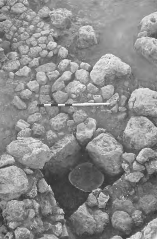 Plate 121d
Locus 512: Portico and storage jar (level 9a)
Briend and Humbert (1980)
- Fig. 5 Succession
of Levels 9 to 11 in the "House of 11th" from Briend and Humbert (1980)
Fig. 5
Succession of Levels 9 to 11 in the "House of 11th"
Briend and Humbert (1980) - Fig. 6 Section of
9A Destruction Layer (Locus 5281) from Briend and Humbert (1980)
Fig. 6
Section of Destruction Layer 5281 (Level 9A)
Briend and Humbert (1980) - Plate 120a Destruction
layer sealing Locus 501(Level 9a) from Briend and Humbert (1980)
Plate 120a
The destruction layer sealing Locus 501(Level 9a)
Briend and Humbert (1980) - Plate 120b brick wall
layer before removal from Briend and Humbert (1980)
Plate 120b
The brick wall layer before removal
Briend and Humbert (1980) - Plate 120c Plan View
of brick wall layer from Briend and Humbert (1980)
Plate 120c
The brick wall layer: plan view.
Briend and Humbert (1980) - Plate 120d Section of
the destruction layer (see fig. 6) from Briend and Humbert (1980)
Plate 120d
Section of the destruction layer (see fig. 6)
Briend and Humbert (1980) - Plate 120e The position
of the racks shows direction of fall of the bricks from Briend and Humbert (1980)
Plate 120e
The position of the racks shows the direction of the fall of the bricks (from left to right)
Briend and Humbert (1980) - Plate 121a Jar bases
stuck in the ground of Locus 606 (level 9a) from Briend and Humbert (1980)
Plate 121a
Jar bases stuck in the ground of Locus 606 (level 9a)
Briend and Humbert (1980) - Plate 121b Jar on
the roof of Locus 501 (level 9a) from Briend and Humbert (1980)
Plate 121b
Jar on the roof of Locus 501 (level 9a)
Briend and Humbert (1980) - Plate 121c floors
above wall 5229 (level 9a) from Briend and Humbert (1980)
Plate 121c
In section: raising the floors above wall 5229 (level 9a)
Briend and Humbert (1980) - Plate 121d Locus 512:
Portico and storage jar (level 9a) from Briend and Humbert (1980)
Plate 121d
Locus 512: Portico and storage jar (level 9a)
Briend and Humbert (1980)

| Effect | Location | Image(s) | Description |
|---|---|---|---|
|
Area B
Tell Keisan: map of the mound and excavation areas.
Stern et al. (1993 v. 3)
Fig. 51Plan of Structures of Level 9A (Area B) Briend and Humbert (1980)
Fig. 52Axonometric view of Level 9a (Area B), and distribution of ceramics. N.B.: The numbering of the objects is that of the plates, or failing that, the inv. no.. Briend and Humbert (1980)
Fig. 7Axonometric view of the "House of 11th" Briend and Humbert (1980) |
Fig. 6
Fig. 6 Section of Destruction Layer 5281 (Level 9A) Briend and Humbert (1980) Plate 120a
Plate 120aThe destruction layer sealing Locus 501(Level 9a) Briend and Humbert (1980) Plate 120d
Plate 120dSection of the destruction layer (see fig. 6) Briend and Humbert (1980) Plate 120b
Plate 120bThe brick wall layer before removal Briend and Humbert (1980) Plate 120c
Plate 120cThe brick wall layer: plan view. Briend and Humbert (1980) |
|
- Modified by JW from Fig. 52 from Briend and Humbert (1980)
 Deformation Map
Modified by JW from Fig. 52 from Briend and Humbert (1980)
- Earthquake Archeological Effects chart
of Rodríguez-Pascua et al (2013: 221-224)
 Earthquake Archeological Effects (EAE)
Rodríguez-Pascua et al (2013: 221-224)
| Effect | Location | Image(s) | Description | Intensity |
|---|---|---|---|---|
|
Area B
Tell Keisan: map of the mound and excavation areas.
Stern et al. (1993 v. 3)
Fig. 51Plan of Structures of Level 9A (Area B) Briend and Humbert (1980)
Fig. 52Axonometric view of Level 9a (Area B), and distribution of ceramics. N.B.: The numbering of the objects is that of the plates, or failing that, the inv. no.. Briend and Humbert (1980)
Fig. 7Axonometric view of the "House of 11th" Briend and Humbert (1980) |
Fig. 6
Fig. 6 Section of Destruction Layer 5281 (Level 9A) Briend and Humbert (1980) Plate 120a
Plate 120aThe destruction layer sealing Locus 501(Level 9a) Briend and Humbert (1980) Plate 120d
Plate 120dSection of the destruction layer (see fig. 6) Briend and Humbert (1980) Plate 120b
Plate 120bThe brick wall layer before removal Briend and Humbert (1980) Plate 120c
Plate 120cThe brick wall layer: plan view. Briend and Humbert (1980) |
|
|