Open this page in a new tab

Mamistra

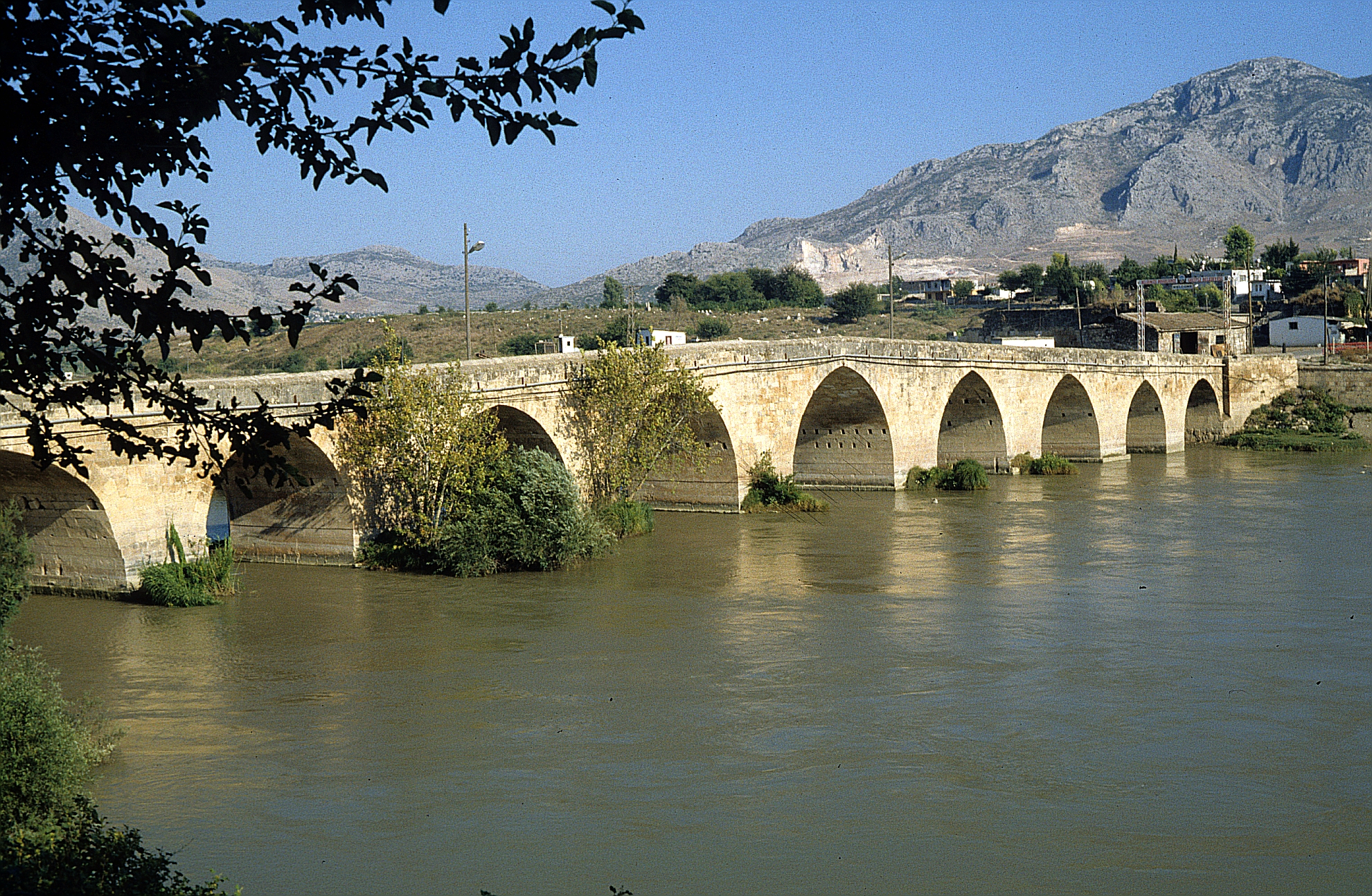
 Roman bridge in Misis-Mopsuestia over the Pyramus River [aka Ceyhan River]

Click on Image to open a higher resolution magnifiable photo in a new tab

Wikipedia - Klaus Peter-Simon - CC BY 3.0


Names
Transliterated Name Source Name
Yakapınar, Yüreğir Modern Turkish
Mamista, Manistra, Mampsista Byzantine Greek Μαμίστα, Μανίστρα, Μαμψίστα
Mopsuestia, Mopsuhestia Greek Μοψουεστία and Μόψου ἑστία
Mopsou Greek Μόψου
Greek Μόψου πόλις
Greek Μόψος
al-Maṣṣīṣah Arabic المصيصة
Msis, Mises, Missis, Messis, Mam(u)estia Armenian Մսիս, Միսիս, Միսիս, Մեսիս, Մամեստիա
Introduction
Introduction

Mamistra, more widely known in Classical sources as Mopsuestia, was an important urban center in southeastern Cilicia, located along the Pyramus River (modern Ceyhan). The settlement occupied a key position controlling movement between the Anatolian interior and northern Syria, and developed into a major node in regional trade and communication networks from the Hellenistic period onward.

The city’s name is traditionally linked to the mythological seer Mopsus, from whom the Greek toponym Μοψουεστία (“hearth of Mopsus”) is derived. In antiquity, the city appears in Greek and Latin sources under a variety of forms, including Μόψου πόλις and Mopsuestia, reflecting its long-standing integration into the Hellenistic and later Roman cultural sphere.

Under the Roman Empire, Mopsuestia became a prominent administrative and ecclesiastical center, benefiting from its location on major road systems linking Antioch, Tarsus, and the Syrian interior. The construction of bridges, fortifications, and public buildings attests to its continued importance into the Byzantine period, when it also served as a bishopric and a regional defensive stronghold along the eastern frontier.

Following the Islamic conquests of the 7th century CE, the city—known in Arabic sources as al-Maṣṣīṣah—became a frontier settlement within the thughūr. Its strategic location ensured repeated cycles of fortification, destruction, and rebuilding, often associated with military campaigns and, at times, earthquake damage recorded in historical chronicles.

From an archaeoseismic perspective, Mamistra occupies a position within a tectonically active zone influenced by the interaction of the Dead Sea Transform and related Anatolian fault systems. Historical accounts of structural damage, repair, and urban reconfiguration suggest that seismic events played a recurring role in shaping the built environment, making the site a potentially valuable locus for integrating textual, archaeological, and geological evidence in regional earthquake chronologies.

Mopsuestia from The Princeton Encyclopedia of Classical Sites
Aerial Views
Aerial Views

Aerial Views

  • Mamistra in Google Earth

Textual Chronology
Earthquake in 756/757/758 CE

Discussion

Discussion

13 November 1114 CE Mamistra Earthquake

Discussion

Discussion

29 November 1114 CE Marash Earthquake

Discussion

Discussion

Textual Seismic Effects
Earthquake in 756/757/758 CE

Effect                                   Location Image(s) Description
  • displaced walls
  • suburb suffered
  • partially destroyed
Mamistra
  • "140/757 : earthquakes in al-Massîsa ; the surrounding wall is weakened. The caliph al-Mansûr decrees the reconstruction of al-Massisa under the responsibility of Djibrayl b. Yahya. The inhabitants of this town were few in number. The wall was rebuilt and the city was called al- Ma`mûra. The construction manager builds a large mosque. He paid the wages of 1000 workers." - Ibn al‑Athir as characterized by Taher (1996)

  • "Masisah. Malmistra according to Latin writers; in Armenian Msis.

    According to The Description of Aleppo (ms. ar. 1683, fol. 67 r.):
    this name includes two towns; between the two flows the Djihân river, the western city is Masisah, the eastern city Kafr-bîà, it was called the little Baghdad (Baghdâd as-Soghrâ)
    Ibn abi-la'koûb said:
    It was built by al-Mansoûr during his caliphate. It was a simple post before him. Al-Mamoûn builds Kafr-bîà; the Djihân river flows between the two places; on this stream there is an old bridge, large and built in stone.
    According to the same author, the citadel of Masisah was built during the reign of Abd al-Malik ibn-Marwân; there was a church that 'Omar ibn' Abd al-'Azîz destroyed. This person had the mosque djâmi built for the locals in the vicinity of Kafr-bîâ. Hishâm ibn 'Abd al-Malik built the suburb of the city that suffered from the earthquake of the year A.H. 140. We still cite al-Mansoûr and al-Mahdî as the builders of this city ; ar-Rashîd built a ditch there. It was taken from the Muslims in 354 of the Hegira by the takafoûr." - Kemal ad-Din (aka Ibn Al-Adim) from Blochet (1900:46 n.3)

  • "Al-Massisah lies on the Nahr Jayhan (the river Pyramus). It was conquered by 'Abd-Allah, son of the Omayyad Caliph 'Abd-al- Malik, in the 1st (7th) century, who rebuilt its fortifications and established a strong garrison here. A mosque was erected on the summit of the hill, and the church in the fortress was turned into a granary. A suburb or second town was built shortly afterwards on the other bank of the Jayhan, called Kafarbayya, where the Caliph Omar II founded a second mosque and dug a great cistern. A third quarter, lying to the east of the Jayhan, was built by the last Omayyad Caliph Marwan II, and named Al-Khusus ; he surrounded it by a wall with a ditch, and wooden doors closed its gateways. Under the Abbasids the Caliph Mansur turned an ancient temple into a Friday Mosque, making it thrice as large as the older mosque of Omar II. Harun-ar-Rashid rebuilt Kafar-bayya, and its mosque was further enlarged by Mamun. The two quarters of Kafarbayya, and Massisah proper were connected by a stone bridge across the Jayhan ; the town bore the title of Al-Ma'muriyah, 'the Populous,' or 'Well-built,' said to have been bestowed upon it by the Caliph Mansur, who restored Massisah after it had been partially destroyed by earthquake in [A.H.] 139 (5 June 756 to 24 May 757 CE). At a later date Massisah, like its neighbours, passed into the possession of the kings of Little Armenia." - unknown Muslim source from Le Strange (1905:130-131)

13 November 1114 CE Mamistra Earthquake

Effect                                   Location Image(s) Description
  • collapsed walls
Mamistra
  • "on the Ides of November, an earthquake at Mamistra destroyed a part of the city" - Fulcher of Chartres

  • "not long afterwards testimony from the town of Mamistra, previously ruined with its citizens and the greater part of the town on the feast of St Brice [13 Nov. 1114 CE], increased their fear. " - Walter the Chancellor

  • "Then the East was shaken by so tremendous an earthquake that it completely destroyed buildings especially in Cilicia, at Malmistra, and all the fortresses in the surrounding area, and in some places nothing was left standing. Men wandered through the fields fearing that they would be swallowed up by the earth. [JW: Andrea Dandolo appears to have amalgamated the 13 and 29 November earthquakes together]" - Andrea Dandolo

29 November 1114 CE Marash Earthquake

Effect                                   Location Image(s) Description
  • collapsed walls
  • fatalities due to collapsed walls
Mamistra
  • "not long afterwards testimony from the town of Mamistra [regarding the 29 November 1114 CE earthquake], previously ruined with its citizens and the greater part of the town on the feast of St Brice [13 Nov. 1114 CE], increased their fear. " - Walter the Chancellor

  • "on this night Samosata, Hisn-Mansur, Kesoun, and Raban were destroyed. On the other hand, Marash was destroyed in such a frightful manner that as many as forty thousand persons died; it was a populous city and yet not one person survived. The same thing happened to the town of Mamistra, where a countless number of men and women perished." - Matthew of Edessa

  • "A great number of cities were ruined: Antioch collapsed, as well as Mecis [Mamistra], Hisn-Mansur, Kayˇsum, Ablastha, R’aban and Samosata." - Chronicle of Smbat Sparapet

Textual Intensity Estimates
Earthquake in 756/757/758 CE

Effect                                   Location Image(s) Description Intensity
  • displaced walls
  • suburb suffered
  • partially destroyed
Mamistra
  • "140/757 : earthquakes in al-Massîsa ; the surrounding wall is weakened. The caliph al-Mansûr decrees the reconstruction of al-Massisa under the responsibility of Djibrayl b. Yahya. The inhabitants of this town were few in number. The wall was rebuilt and the city was called al- Ma`mûra. The construction manager builds a large mosque. He paid the wages of 1000 workers." - Ibn al‑Athir as characterized by Taher (1996)

  • "Masisah. Malmistra according to Latin writers; in Armenian Msis.

    According to The Description of Aleppo (ms. ar. 1683, fol. 67 r.):
    this name includes two towns; between the two flows the Djihân river, the western city is Masisah, the eastern city Kafr-bîà, it was called the little Baghdad (Baghdâd as-Soghrâ)
    Ibn abi-la'koûb said:
    It was built by al-Mansoûr during his caliphate. It was a simple post before him. Al-Mamoûn builds Kafr-bîà; the Djihân river flows between the two places; on this stream there is an old bridge, large and built in stone.
    According to the same author, the citadel of Masisah was built during the reign of Abd al-Malik ibn-Marwân; there was a church that 'Omar ibn' Abd al-'Azîz destroyed. This person had the mosque djâmi built for the locals in the vicinity of Kafr-bîâ. Hishâm ibn 'Abd al-Malik built the suburb of the city that suffered from the earthquake of the year A.H. 140. We still cite al-Mansoûr and al-Mahdî as the builders of this city ; ar-Rashîd built a ditch there. It was taken from the Muslims in 354 of the Hegira by the takafoûr." - Kemal ad-Din (aka Ibn Al-Adim) from Blochet (1900:46 n.3)

  • "Al-Massisah lies on the Nahr Jayhan (the river Pyramus). It was conquered by 'Abd-Allah, son of the Omayyad Caliph 'Abd-al- Malik, in the 1st (7th) century, who rebuilt its fortifications and established a strong garrison here. A mosque was erected on the summit of the hill, and the church in the fortress was turned into a granary. A suburb or second town was built shortly afterwards on the other bank of the Jayhan, called Kafarbayya, where the Caliph Omar II founded a second mosque and dug a great cistern. A third quarter, lying to the east of the Jayhan, was built by the last Omayyad Caliph Marwan II, and named Al-Khusus ; he surrounded it by a wall with a ditch, and wooden doors closed its gateways. Under the Abbasids the Caliph Mansur turned an ancient temple into a Friday Mosque, making it thrice as large as the older mosque of Omar II. Harun-ar-Rashid rebuilt Kafar-bayya, and its mosque was further enlarged by Mamun. The two quarters of Kafarbayya, and Massisah proper were connected by a stone bridge across the Jayhan ; the town bore the title of Al-Ma'muriyah, 'the Populous,' or 'Well-built,' said to have been bestowed upon it by the Caliph Mansur, who restored Massisah after it had been partially destroyed by earthquake in [A.H.] 139 (5 June 756 to 24 May 757 CE). At a later date Massisah, like its neighbours, passed into the possession of the kings of Little Armenia." - unknown Muslim source from Le Strange (1905:130-131)
  • VII+
This evidence requires a minimum Intensity of VII (7) when using the Earthquake Archeological Effects chart of Rodríguez-Pascua et al (2013: 221-224).

13 November 1114 CE Mamistra Earthquake

Effect                                   Location Image(s) Description Intensity
  • collapsed walls
Mamistra
  • "on the Ides of November, an earthquake at Mamistra destroyed a part of the city" - Fulcher of Chartres

  • "not long afterwards testimony from the town of Mamistra, previously ruined with its citizens and the greater part of the town on the feast of St Brice [13 Nov. 1114 CE], increased their fear. " - Walter the Chancellor

  • "Then the East was shaken by so tremendous an earthquake that it completely destroyed buildings especially in Cilicia, at Malmistra, and all the fortresses in the surrounding area, and in some places nothing was left standing. Men wandered through the fields fearing that they would be swallowed up by the earth. [JW: Andrea Dandolo appears to have amalgamated the 13 and 29 November earthquakes together]" - Andrea Dandolo
  • VIII+
This evidence requires a minimum Intensity of VIII (8) when using the Earthquake Archeological Effects chart of Rodríguez-Pascua et al (2013: 221-224).

29 November 1114 CE Marash Earthquake

Effect                                   Location Image(s) Description Intensity
  • collapsed walls
  • fatalities due to collapsed walls
Mamistra
  • "not long afterwards testimony from the town of Mamistra [regarding the 29 November 1114 CE earthquake], previously ruined with its citizens and the greater part of the town on the feast of St Brice [13 Nov. 1114 CE], increased their fear. " - Walter the Chancellor

  • "on this night Samosata, Hisn-Mansur, Kesoun, and Raban were destroyed. On the other hand, Marash was destroyed in such a frightful manner that as many as forty thousand persons died; it was a populous city and yet not one person survived. The same thing happened to the town of Mamistra, where a countless number of men and women perished." - Matthew of Edessa

  • "A great number of cities were ruined: Antioch collapsed, as well as Mecis [Mamistra], Hisn-Mansur, Kayˇsum, Ablastha, R’aban and Samosata." - Chronicle of Smbat Sparapet
  • VIII+
  • VIII+
This evidence requires a minimum Intensity of VIII (8) when using the Earthquake Archeological Effects chart of Rodríguez-Pascua et al (2013: 221-224).

Notes and Further Reading
References

References from Wikipedia

  1. Harry Thurston Peck, Harpers Dictionary of Classical Antiquities (1898), Mopsuestia
  2. Charlton T. Lewis, Charles Short, A Latin Dictionary, Mopsuestia
  3. Vailhé, Siméon (1911). "Mopsuestia" . Catholic Encyclopedia. Vol. 10.
  4. Normand Robert, La Cilicia. In: Annals of Geography. 1920, vol. 29, No. 162. p.p. 426-451
  5. Missis and its Roman bridge
  6. GREEK ANTHOLOGY, § 9.698
  7. Procopius, On Buildings, §5.5.1
  8. Jump up to: a b Stephanus of Byzantium, Ethnica, § M459.1
  9. Eusebius, Chronography, 97-98
  10. Annuario Pontificio 2013 (Libreria Editrice Vaticana, 2013, ISBN 978-88-209-9070-1), p. 933
  11. Jump up to: a b Edwards, Robert W. (1987). The Fortifications of Armenian Cilicia: Dumbarton Oaks Studies XXIII. Washington, D.C.: Dumbarton Oaks, Trustees for Harvard University. pp. 198–200, 284. ISBN 0-88402-163-7.
  12. Edwards, Robert W., "Mopsuestia" (2016). The Eerdmans Encyclopedia of Early Christian Art and Archaeology, ed., Paul Corby Finney. Grand Rapids, Michigan: William B. Eerdmans Publishing. p. 168. ISBN 978-0-8028-9017-7.
  13. Langlois, V. (1861). Voyage dans la Cilicie et dans les montagnes du Taurus, exécuté pendant les années 1852-1853. Paris. p. 451.
  14. Missis and its Roman bridge
  15. Athenaeus, Deipnosophists, §6.234b

Wikipedia pages

Mopsuestia


Mopsucrene


Yakapınar, Yüreğir