Stern et al (1993 v. 2)
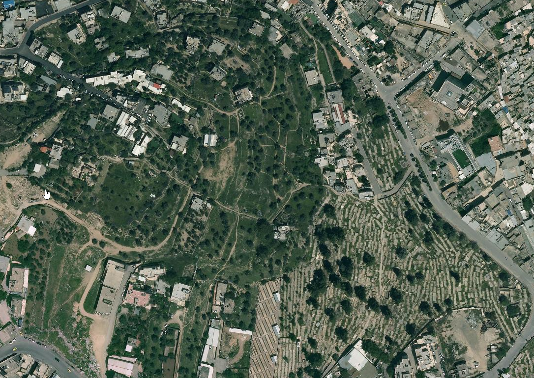
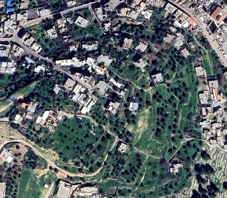
Tel Hebron lies on a secondary spur of Jebel Rumeida,
overlooking the city of Hebron from the south. The first
settlement was established near a spring ('Ein Judeida)
and near an area of cultivated plots in the Hebron Valley.
Topographically, the mound is not easily defensible, as it
is dominated on the southwest by Jebel Rumeida. The debris
on the mound covers an area of some 17 a., but the area of
the ancient city was probably not more than 12 a.
The renewed excavations at Hebron were based on a central
section (area S), intended to cut through the entire mound
and determine its stratigraphical sequence. Thanks to the
Middle Bronze Age city wall, it is possible to associate the
other excavated areas, as well as some of the areas excavated
by Hammond, with the section and its strata.
Area S. A stratigraphical sequence from the Early Arab
period, Byzantine period (two phases), Roman period,
Hellenistic period, Iron Age II (two phases), Iron Age
IIA–IB (two phases), Iron Age I, and Middle Bronze Age
has so far been exposed in Area S. The excavators have
reached the top of an as yet unexcavated stratum, that dates
to the end of the Early Bronze Age.
The most important
structure in this area, ascribed to the Middle Bronze Age, is
situated near the city wall. One room was used to collect
ashes, animal bones, and potsherds. Also discovered in this
room was a well-baked clay tablet, inscribed in Akkadian
cuneiform, including a list of animals, most probably offered
as sacrifices. Also mentioned in the tablet are the names of
four people and possibly also a king. The animals listed
include only sheep and goats; this complies with the great
quantity of bones found at the site, most of which are from
sheep and goats. The pottery uncovered here appears to
represent a broad range of phases of the Middle Bronze Age.
Discovered near the document was a bulla with scarab
impressions from the time of the Twelfth Dynasty in Egypt;
the finds in a nearby room included a socketed ax from the
same period.
Area 13 (Southern City Wall). Exposed in Area 13 was the
Middle Bronze Age city wall, which rose to a height of more
than 2 m above the surface even before excavations began.
Outside the wall the excavators reached bedrock, on which
an Early Bronze Age I stratum was found. Incorporated in
the wall from the inside was a fortified tower that exhibited
evidence of repairs and repeated use during the Iron Age.
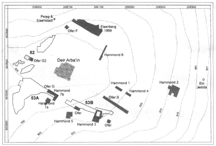
Area G. In Area G, in the western part of the mound, a large
building, whose beginnings go back to the Hellenistic
period, was uncovered. Its outer wall was excavated by
Hammond as Area 17 and first mistakenly identified as part
of the Middle Bronze Age wall. The structure continued in
use in the Roman period, during which it was destroyed
twice, probably in the first and second centuries CE. Its
walls were reused in the Byzantine period. Also exposed here
was the outer face of the Middle Bronze Age wall, against
which a stone glacis was later built. Area G presents the
easiest access to the mound. The excavators found indications
of a rock-hewn fosse, and the city gate may have stood here
as well.
Area F (Northern City Wall). Area F yielded the continuation
of the Middle Bronze Age wall. Outside the wall was a
revetment, which should probably be dated to the eleventh
and tenth centuries BCE. If that is indeed the case, it would
prove that the Iron Age city expanded beyond the limits of
the Middle Bronze Age walls.
Area W. Hebron’s water source, 'Ein Judeida (New Spring),
is in Area W (in the eastern and lowest part of the mound).
The spring, whose water remains very cold throughout the
year, was originally a surface groundwater spring. As the
area of the spring was buried under debris accumulating
from the mound, a domed structure was built over the site
(in the Middle Ages?). Debris continued to accumulate on
top of the dome, to the extent that today the spring seems
to be flowing from a cave. A massive wall built at the inner
end of the spring pool may be concealing a water system
hewn inside the mound, but this is a conjecture that requires
further research.
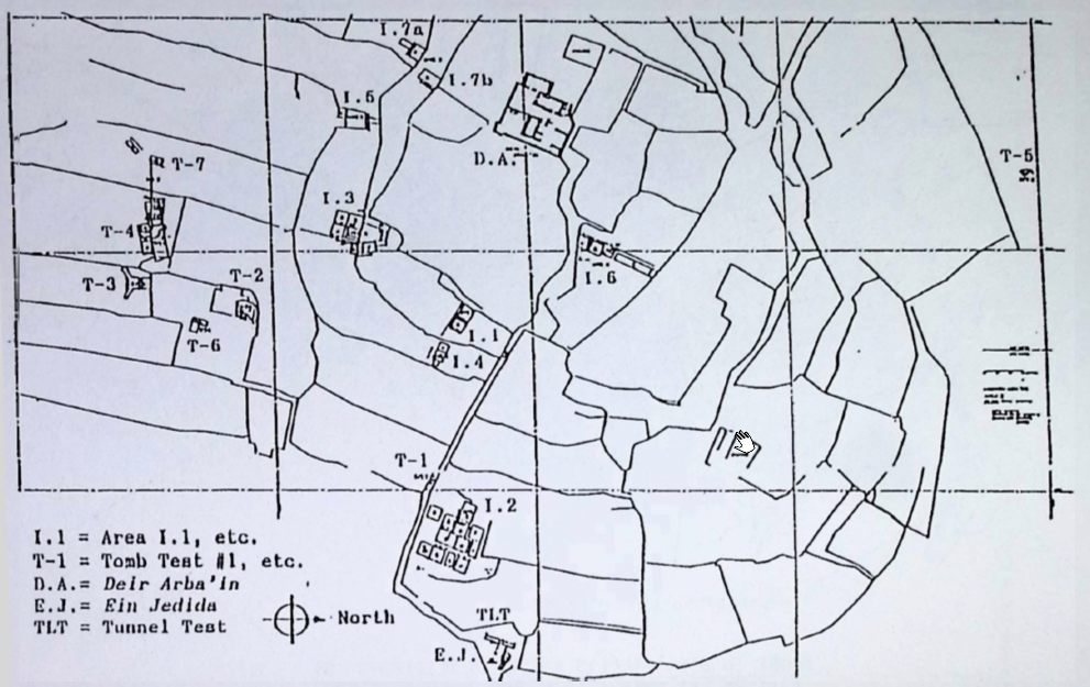
Area 11. Hammond excavated Area 11 (east of Area S),
uncovering levels from the Early Bronze Age I, Middle
Bronze Age, Iron Age I, and Iron Age II. He reported the
discovery of a well-built pillared house from the Iron Age
II.
Area 14. One terrace below Area 11 is Area 14. Here Hammond
reported the presence of Arab buildings, overlying earlier
remains, down to the Early Bronze Age I.
Area 16. The only area excavated to date on the acropolis of
the mound is Area 16. It presented the stratigraphical
sequence regularly found at Tel Hebron. Particularly
noteworthy is the rich and dense occupation during the Iron
Age. Hammond also found here a scarab of Ramesses II, but
until his excavations become fully published, the level to
which the scarab should be assigned remains unknown.
Area 12. A group of buildings which Hammond ascribed to the
Early Arab period belongs to Area 12 (the eastern part of the
mound). He also reported a complete sequence (at least in
terms of pottery) of the other known periods of the mound,
and similarly in Area 15 (in the southwest of the mound).
Hammond’s expedition also exposed some burial caves, mainly
in the southeastern part of the mound. Some of them date to
the Early Bronze Age I. He reported continuous occupation
for one burial cave from the Middle Bronze Age through the
Late Bronze Age (including Cypriot pottery) and perhaps also
the Iron Age I.
Also noteworthy is Deir el-Arba‘in, a building
at the summit of the mound, built on Byzantine foundations;
the superstructure is probably later, perhaps from the
Crusader period. Since the Middle Ages, popular tradition
has identified the building with the tombs of Ruth and Jesse
(David’s father), but there is no basis for this identification.
SUMMARY. The earliest known occupation of the mound was in
the Early Bronze Age I, as part of a wave of settlement that
occurred throughout the entire hill region. However, the only
remains of this stratum exposed so far are a few sections of
walls and rock shelters that apparently also served as
dwellings.
Settlement continued through the Early Bronze Age
II–III, but no remains have been excavated as yet. It is not
clearly understood whether the site was completely abandoned
during the Intermediate Bronze Age (Middle Bronze Age I). In
any event, the shaft tombs within the modern city limits
testify that the area was at the very least a tribal-nomadic
center, like other sites in the hill region.
During the Middle Bronze Age II the site was occupied by a
fortified city, some 6 to 7 a. in area, surrounded by a
cyclopean wall. This city was the major settlement in the
Judean Hills during the Middle Bronze Age. The cuneiform
tablet dated to this period testifies to the city’s central
role in the administration, apparently as the capital of a
kingdom. The list of animals in the tablet, together with the
bones found in the area, indicate that the local inhabitants
were shepherds. The proper names on the tablet indicate a
West Semitic (Amorite) population, with a Hurrian minority.
During the Late Bronze Age, the city of Hebron was
abandoned; however, a tribal population continued to bury its
dead in the environs, and even on the outskirts of Tel
Hebron. It is possible that a small part of the site itself,
besides serving as a necropolis, was also used for
residential purposes. However, it would seem that during the
Late Bronze Age there was no large, permanent settlement on
the site. The permanent occupation of Hebron was resumed in the first
phase of Iron Age I, apparently by the tribal unit known as
the Calebites. Judging from the finds, it is unlikely that
Hebron was a fortified town on the eve of the Israelite
settlement. This detail in the Calebite tradition is probably
etiological, a conjecture on the part of a late writer, who
was probably familiar with the ancient cyclopean walls of
Hebron and associated them with the tradition telling of the
war with the Anakites. In fact, parts of these walls are
still visible on the mound; in the Iron Age they rose to an
even greater height and were probably a familiar sight and
may well have been reused. The glacis (if such existed) was
partly destroyed before the Iron Age.
The next occupational level at Tel Hebron represents the
zenith of the city’s history, between the eleventh century
and the end of the tenth century BCE. During that time the
city probably extended beyond the line of the Middle Bronze
Age walls. The latter were presumably used as fortifications
for the upper sector of the city. Historically speaking, this
golden age at Hebron reflects the city’s position as a tribal
and religious center for the people of the Judean Hills and
the first royal capital of King David.
In the later part of the Iron Age, Hebron's importance
declined; the remains exposed from this phase are
fragmentary. Hammond's excavations probably exposed more
abundant evidence from the period of the monarchy, but it has
not been published. The precise history of Hebron during that
period, including the date of its final destruction, is
unclear. An important find from the time of the monarchy are
five
lamelekh seal impressions on 609 storage jar handles.
All five feature the two-winged symbol, and the two inscribed
ones include the name Hebron. Notably, of the four cities
named in the
lamelekh seal impressions, Hebron is the only
one that has also been confidently identified and excavated;
hence, the considerable significance of the find.
During the Persian period Tel Hebron was completely abandoned;
in subsequent periods the city shifted to its present location
in the valley, at the foot of the mound. As the city of Hebron
has not been excavated, it cannot be determined whether
occupation of the area began during the Persian period.
Occupation of the mound resumed in the Hellenistic period,
probably as a suburb of the lower city. During the Roman
period, settlement flourished; to this period are dated pool
installations of an uncertain, perhaps industrial, nature.
Two violent destruction levels belong to this period—the first
probably under Vespasian, the second perhaps during the
Bar-Kokhba Revolt. The remains from the Byzantine period
comprise two phases, and occupation continued into the
Umayyad, Crusader, and Mamluk periods. Only in the Ottoman
period was the mound completely abandoned.
 Tell Rumeida
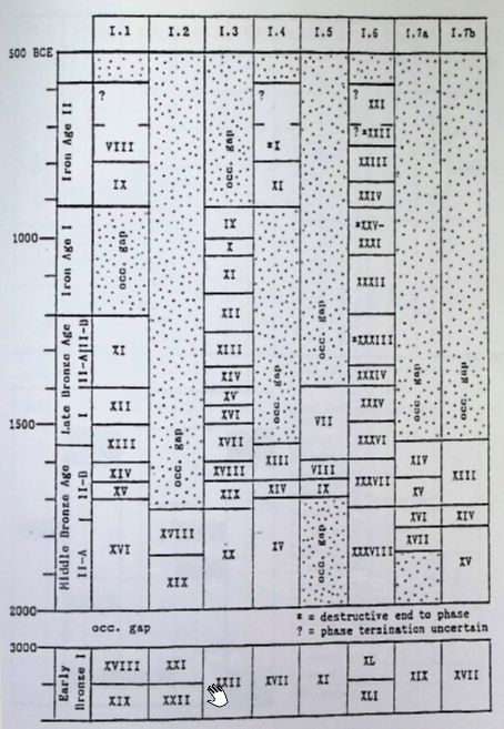 American Expedition to Hebron (A.E.H.) Phasing at Tell Rumeida
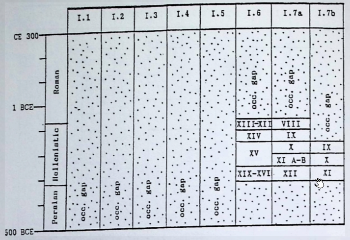 American Expedition to Hebron (A.E.H.) Phasing at Tell Rumeida
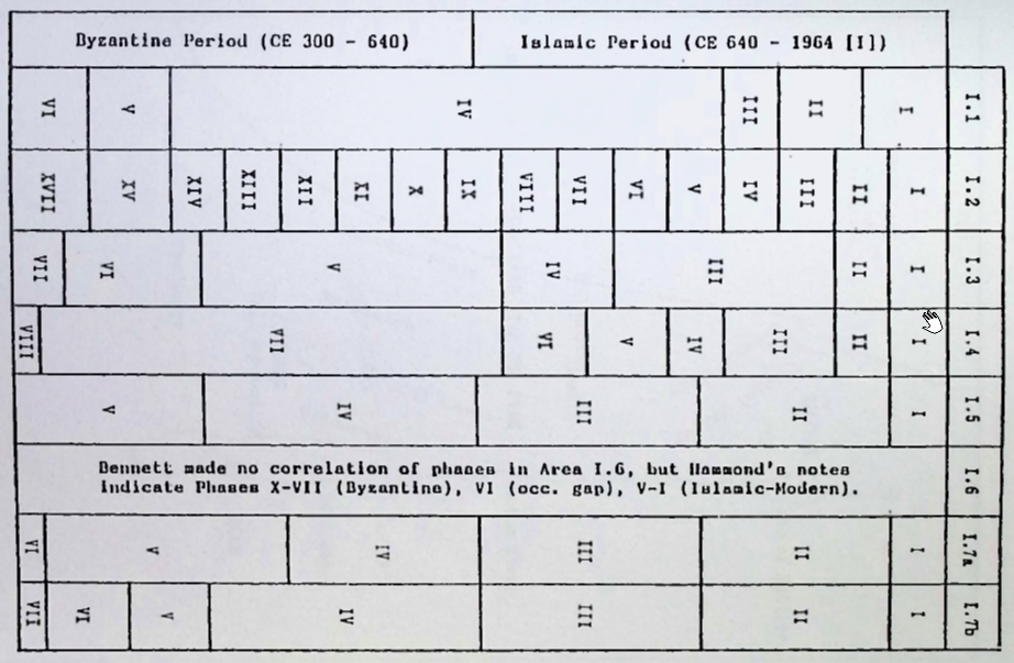 American Expedition to Hebron (A.E.H.) Phasing at Tell Rumeida
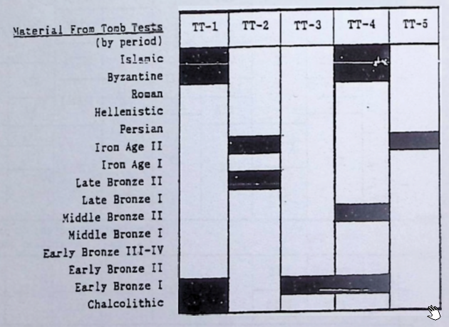 Material from Tomb Tests at Tell Rumeida