Banias
 Banias
click on image to explore this site on a new tab in Google Earth
- Location Map for Banias
(aka Caesarea Philippi) from biblewalks.com
- Fig. 3 - Location Map
(Palestine) from Burton, J. (2010)
 Fig. 3
Map of Palestine indicating Banias (marked as Caesarea Philippi) in the North
Burton (2010) - Fig. 4 - Location Map
(Upper Galilee) from Burton, J. (2010)
 Fig. 4
Map of the Upper Galilee and the Banias Region during the First Century AD
Burton (2010)

- Fig. 3 - Location Map
(Palestine) from Burton, J. (2010)
Fig. 3
Map of Palestine indicating Banias (marked as Caesarea Philippi) in the North
Burton (2010)
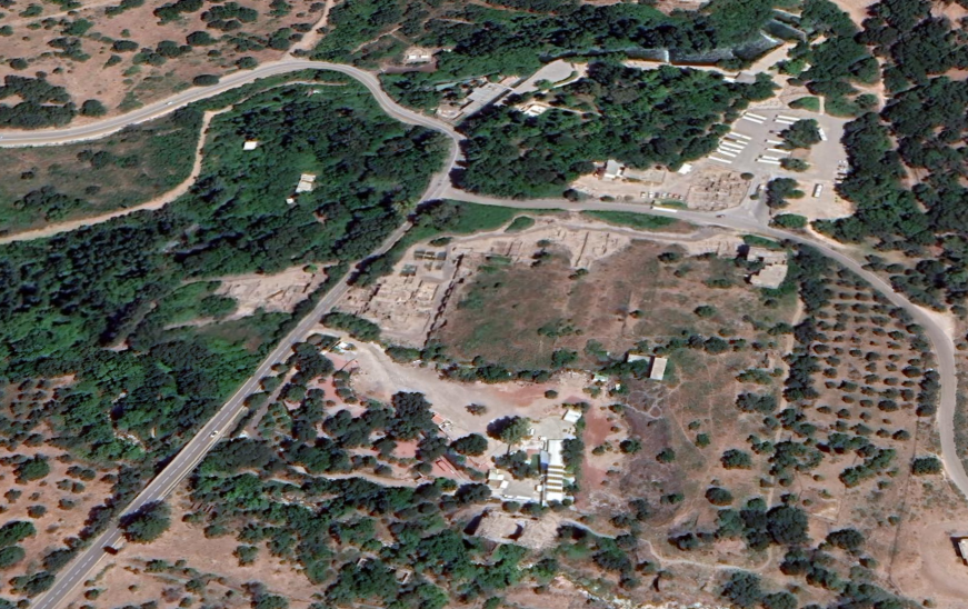
- Annotated Satellite Image (google) of
Banias area from biblewalks.com
- Fig. 2 - Aerial View of the Site.
from Wilson (2004)
 Fig. 2
Aerial View of the Site. The site of ancient Banias as seen from the fortress of Subaybah [aka Nimrod's Fortress]
- Modern Israeli settlement of Snir
- Site of ancient Dan
- The road to Tyre and the Mediterranean
- Unexcavated Roman villas
- The Roman and Byzantine necropolis
- The Cave of Pan
- Civic Centre.
- Site of the Royal Palace
- The southern entrance gate
- Course of the Banias River
- Course of Wâdî Sa‘âr
- Road to Damascus
- Tel ‘Azzaziya-t
- The Huleh
Wilson (2004) - Aerial View of the town
center from Stern et al (2008)
 Banias: aerial view of the town center
Stern et al (2008) - Banias in Google Earth
Banias
click on image to explore this site on a new tab in Google Earth - Banias on govmap.gov.il
 Banias
click on image to explore this site on a new tab in govmap.gov.il

- Fig. 1.1 - Survey Map of Banyias
from Hartal (2009)
 Fig. 1.1
Survey map of Banyias.
Hartal (2009) - Fig. 1.1 - Key to Survey Map of Banyias
from Hartal (2009)
 Fig. 1.1
Key to Survey map of Banyias.
Hartal (2009) - Fig. 1 - Site Map of Banias
from Wilson (2004)
 Fig. 1
Plan of the Ancient City
Wilson (2004) - Plan of the town center
with excavation areas from Stern et al (2008)
 Banias: plan of the town center, showing excavation areas
Stern et al (2008) - Plan of the sanctuary
of Pan from Stern et al (2008)
 Plan of the sanctuary of Pan
Stern et al (2008)
- Plan of the town center
with excavation areas from Stern et al (2008)
Banias: plan of the town center, showing excavation areas
Stern et al (2008) - Plan of the sanctuary
of Pan from Stern et al (2008)
Plan of the sanctuary of Pan
Stern et al (2008)
- Artist's Rendition of Banias
from biblewalks.com
- Reconstructed view of
the temples at the sanctuary of Pan from biblewalks.com
 Reconstructed view of the temples at the sanctuary of Pan
click on image to open a high res magnifiable image in a new tab
Drawing by Grandma Rina
Used with permission from BibleWalks.com

- Fig. 1 - Site Map of Banias
from Wilson (2004)
Fig. 1
Plan of the Ancient City
Wilson (2004) - Fig. 41 - Jahârkas’s inscription
from Wilson (2004)
 Fig. 41
Jahârkas’s inscription
Inscription, dated 1204–5 AD, found during the modern excavation of the city. It commemorates Fakhr al-Dîn Iyâs Jahârkas, a Mamlûk of Saladin who became governor of the area around Banias in 1201 and made the town his capitol. The stone is reused, probably originally belonging to a building from Roman times.
Wilson (2004)
- Fig. 1 - Site Map of Banias
from Wilson (2004)
Fig. 1
Plan of the Ancient City
Wilson (2004) - Fig. 37 - Broken Pottery
in the ‘Street of Burnt Shops’ [aka Byzantine Street of Shops] from Wilson (2004)
 Fig. 37
The ‘Street of Burnt Shops’ [aka Byzantine Street of Shops] as discovered
Wilson (2004)
- Fig. 1 - Site Map of Banias
from Wilson (2004)
Fig. 1
Plan of the Ancient City
Wilson (2004) - Fig. 1.1 - Survey Map of Banyias
from Hartal (2009)
Fig. 1.1
Survey map of Banyias.
Hartal (2009) - Fig. 1.1 - Key to Survey Map of Banyias
from Hartal (2009)
Fig. 1.1
Key to Survey map of Banyias.
Hartal (2009)
| Effect | Location | Image(s) | Description |
|---|---|---|---|
|
four shops along the western side of the Byzantine Street of Shops (aka 'Street of Burnt Shops') in Area F - possibly along the eastern side as well.
Potential archaeoseismic evidence in the Cardo too.
Fig. 1 Plan of the Ancient City Wilson (2004)
Banias: plan of the town center, showing excavation areasStern et al (2008) |
Fig. 37 The ‘Street of Burnt Shops’ [aka Byzantine Street of Shops] as discovered Wilson (2004) 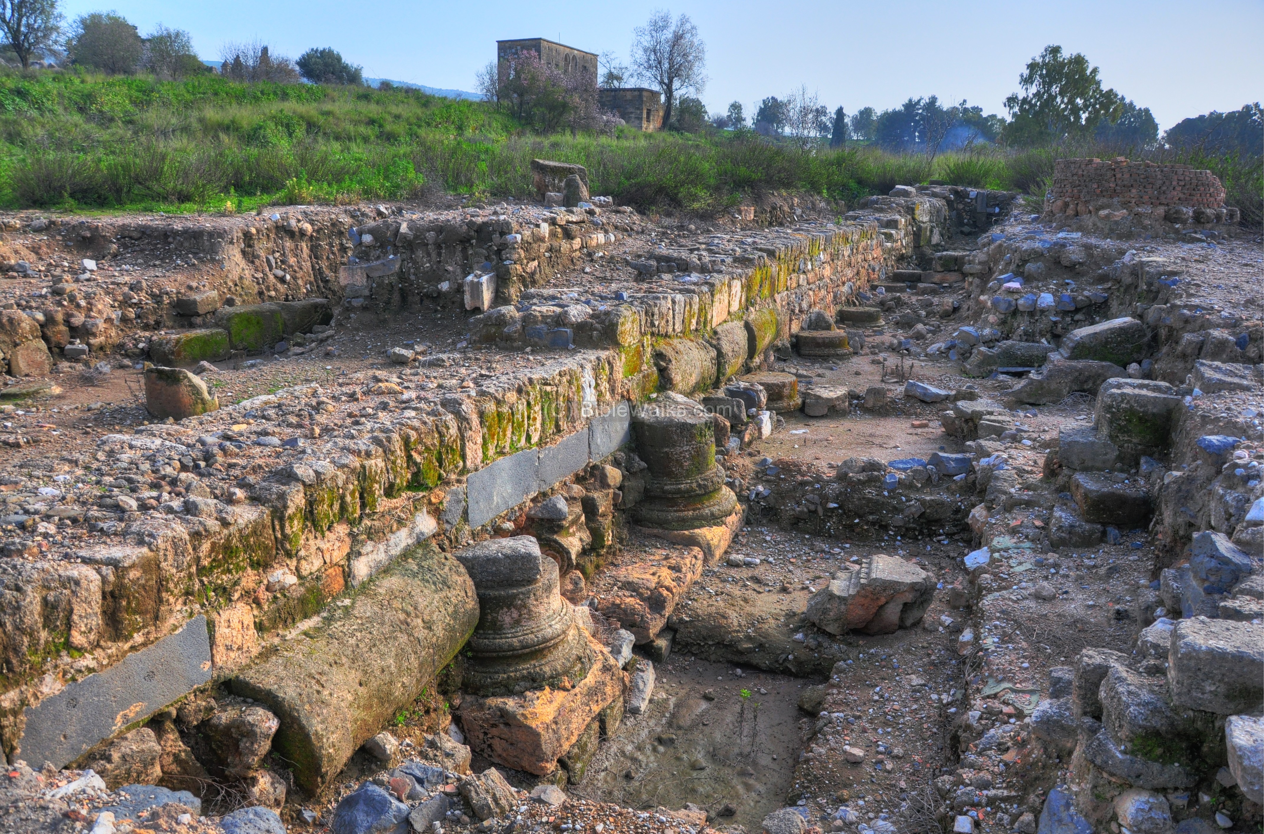 The excavated Cardo in the Byzantine City
click on image to open a high res magnifiable image in a new tab Used with permission from BibleWalks.com 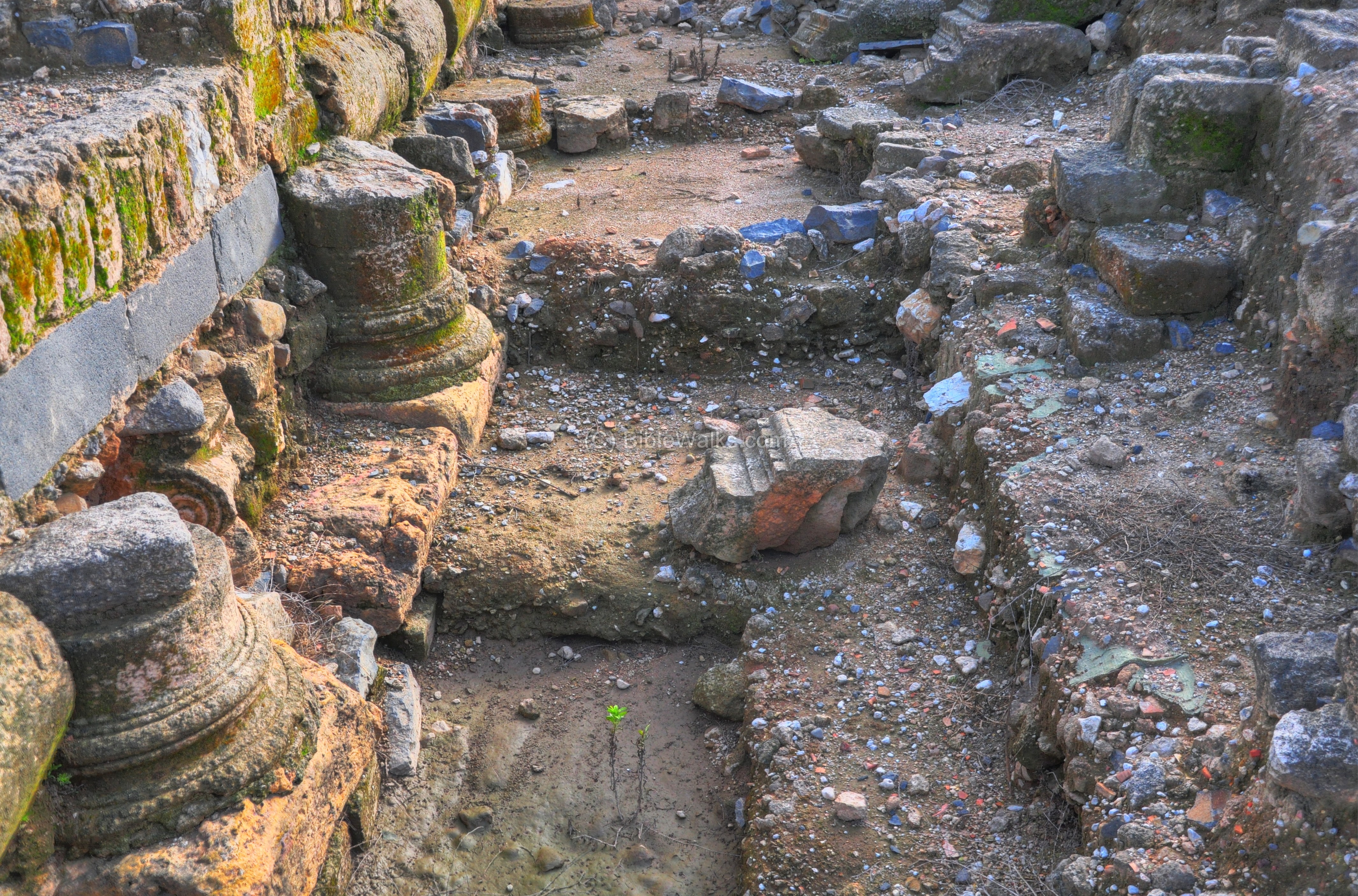 detail of the column bases along the Cardo
click on image to open a high res magnifiable image in a new tab Used with permission from BibleWalks.com |
|
| Effect | Location | Image(s) | Description |
|---|---|---|---|
| Possible Cave Collapse | Cave of Pan
Fig. 1 Plan of the Ancient City Wilson (2004)
Plan of the sanctuary of PanStern et al (2008) 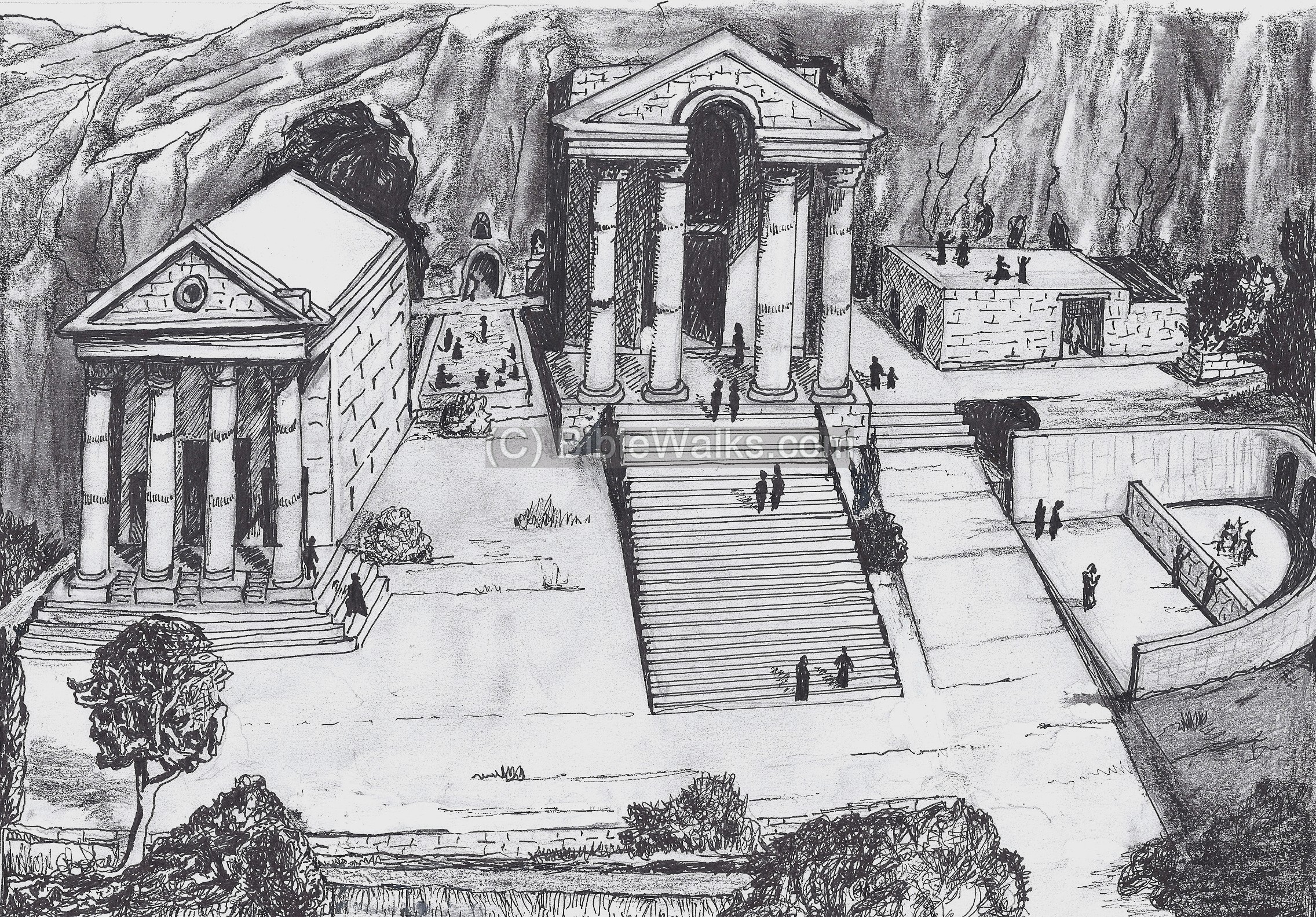 Reconstructed view of the temples at the sanctuary of Pan
click on image to open a high res magnifiable image in a new tab Drawing by Grandma Rina Used with permission from BibleWalks.com |
 Court of Pan and the Nymphs; the cave is to the far lef
JW: Note human next to huge boulders in the lower left Stern et al (2008) 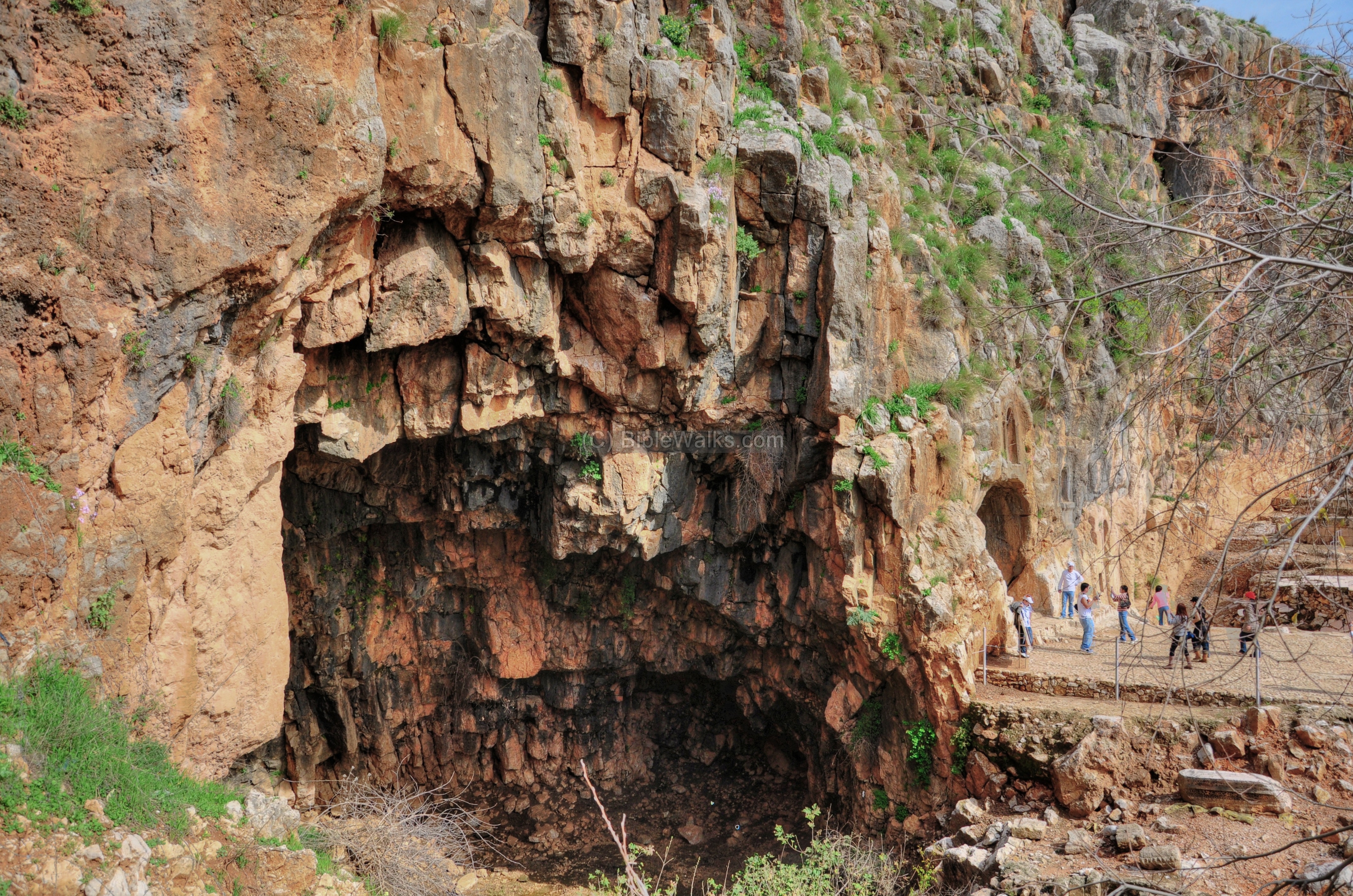 Cave of Pan
click on image to open a high res magnifiable image in a new tab Used with permission from BibleWalks.com |
|
- Earthquake Archeological Effects chart
of Rodríguez-Pascua et al (2013: 221-224)
 Earthquake Archeological Effects (EAE)
Rodríguez-Pascua et al (2013: 221-224)
| Effect | Location | Image(s) | Description | Intensity |
|---|---|---|---|---|
|
Banias |
|
|
- Earthquake Archeological Effects chart
of Rodríguez-Pascua et al (2013: 221-224)
Earthquake Archeological Effects (EAE)
Rodríguez-Pascua et al (2013: 221-224)
| Effect | Location | Image(s) | Description | Intensity |
|---|---|---|---|---|
|
Banias |
|
|
|
|
Banias |
|
|
- Earthquake Archeological Effects chart
of Rodríguez-Pascua et al (2013: 221-224)
Earthquake Archeological Effects (EAE)
Rodríguez-Pascua et al (2013: 221-224)
| Effect | Location | Image(s) | Description | Intensity |
|---|---|---|---|---|
|
Banias |
|
|
- Earthquake Archeological Effects chart
of Rodríguez-Pascua et al (2013: 221-224)
Earthquake Archeological Effects (EAE)
Rodríguez-Pascua et al (2013: 221-224)
| Effect | Location | Image(s) | Description | Intensity |
|---|---|---|---|---|
|
Banias |
|
VIII+ |
- Earthquake Archeological Effects chart
of Rodríguez-Pascua et al (2013: 221-224)
Earthquake Archeological Effects (EAE)
Rodríguez-Pascua et al (2013: 221-224)
| Effect | Location | Image(s) | Description | Intensity |
|---|---|---|---|---|
| Damage | Banias | Zohar et al. (2016: Table 3) reports damage to Baniyas. | VII ? |
- Earthquake Archeological Effects chart
of Rodríguez-Pascua et al (2013: 221-224)
Earthquake Archeological Effects (EAE)
Rodríguez-Pascua et al (2013: 221-224)
| Effect | Location | Image(s) | Description | Intensity |
|---|---|---|---|---|
|
four shops along the western side of the Byzantine Street of Shops (aka 'Street of Burnt Shops') in Area F - possibly along the eastern side as well.
Potential archaeoseismic evidence in the Cardo too.
Fig. 1 Plan of the Ancient City Wilson (2004)
Banias: plan of the town center, showing excavation areasStern et al (2008) |
Fig. 37 The ‘Street of Burnt Shops’ [aka Byzantine Street of Shops] as discovered Wilson (2004)
The excavated Cardo in the Byzantine Cityclick on image to open a high res magnifiable image in a new tab Used with permission from BibleWalks.com
detail of the column bases along the Cardoclick on image to open a high res magnifiable image in a new tab Used with permission from BibleWalks.com |
|
|
- Earthquake Archeological Effects chart
of Rodríguez-Pascua et al (2013: 221-224)
Earthquake Archeological Effects (EAE)
Rodríguez-Pascua et al (2013: 221-224)
| Effect | Location | Image(s) | Description | Intensity |
|---|---|---|---|---|
| Possible Cave Collapse - Collapses in Caves or Vault Collapse | Cave of Pan
Fig. 1 Plan of the Ancient City Wilson (2004)
Plan of the sanctuary of PanStern et al (2008)
Reconstructed view of the temples at the sanctuary of Panclick on image to open a high res magnifiable image in a new tab Drawing by Grandma Rina Used with permission from BibleWalks.com |
Court of Pan and the Nymphs; the cave is to the far lef JW: Note human next to huge boulders in the lower left Stern et al (2008)
Cave of Panclick on image to open a high res magnifiable image in a new tab Used with permission from BibleWalks.com |
|
III+ or VIII+ |