Archeological References
Chronology
Encyclopedias
Stern, E., et al. (1993).
The New Encyclopedia of Archaeological Excavations in the Holy Land, Israel Exploration Society & Carta. Volume 1 - Abila to Elusa..
1
Stern, et al. (1993). The New Encyclopedia of Archaeological Excavations in the Holy Land,
Israel Exploration Society & Carta. Volume 2 - Emmaus to Jerusalem - can be borrowed with a free acount at archive.org..
2
Stern, et al. (1993). The New Encyclopedia of Archaeological Excavations in the Holy Land,
Israel Exploration Society & Carta. Volume 3 - Jokneam to Pella - can be borrowed with a free acount at archive.org..
3
Stern, et al. (1993). The New Encyclopedia of Archaeological Excavations in the Holy Land, Israel Exploration Society & Carta. Volume 4 - Petra to Ziqim..
4
Stern, et al. (2008). The New Encyclopedia of Archaeological Excavations in the Holy Land, Israel Exploration Society & Carta. Volume 5 Supplement..
5
The New Encyclopedia of Archaeological Excavations in the Holy Land at BAS
(Biblical Archaeology Society) - requires a membership to access


References
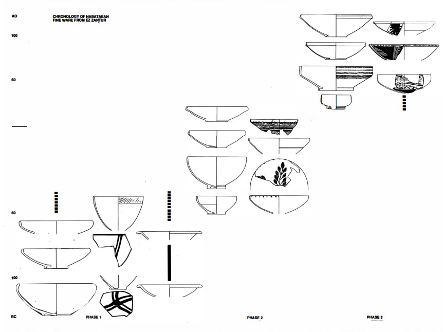
Pottery
- from Schmid (1995)
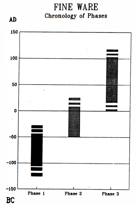
Left
Chronology of Nabatean finewares
Right
Typology and chronology of the Nabataean fine ware
Both from Schmid (1995)
- from Dolinka (2006) citing Schmid (2000)
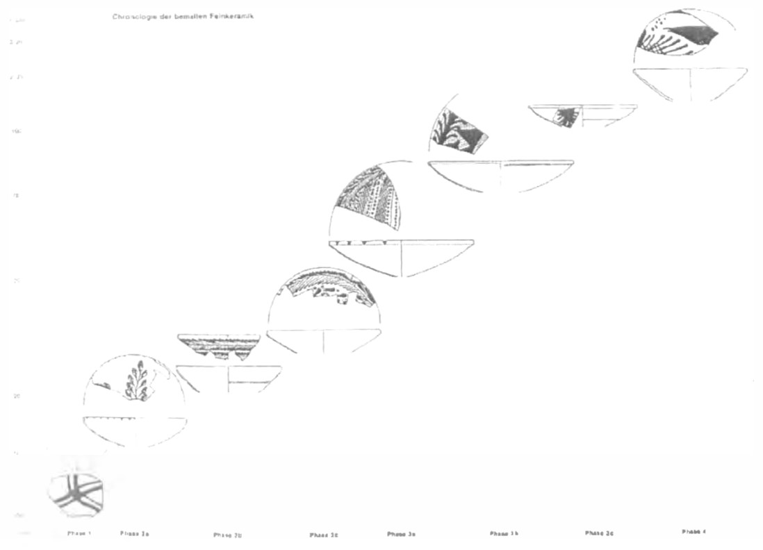 Figure 1.3
Typo-chronology for the NPFW bowls developed by Schmid (2000: abb. 98)
Dolinka (2006)
Journals and Publications
Aerial Images
Inscriptions
Papyri
Other References
Maps and Archaeological Maps
- Fig. 2.1 Early Bronze I Sites
from Greenberg (2019)
 Fig. 2.1
Map of sites mentioned in this chapter
Greenberg (2019) - Fig. 3.1 Early Bronze II and III Sites
from Greenberg (2019)
 Fig. 3.1
Map of sites mentioned in this chapter
Greenberg (2019) - Fig. 4.1 Intermediate Bronze Sites
from Greenberg (2019)
 Fig. 4.1
Map of sites mentioned in this chapter
Greenberg (2019) - Fig. 5.2 Middle Bronze Sites
from Greenberg (2019)
 Fig. 5.2
Map of sites mentioned in this chapter
Greenberg (2019) - Fig. 6.1 Late Bronze Sites
from Greenberg (2019)
 Fig. 6.1
Map of sites mentioned in this chapter
Greenberg (2019)
- Fig. 2.1 Early Bronze I Sites
from Greenberg (2019)
Fig. 2.1
Map of sites mentioned in this chapter
Greenberg (2019) - Fig. 3.1 Early Bronze II and III Sites
from Greenberg (2019)
Fig. 3.1
Map of sites mentioned in this chapter
Greenberg (2019) - Fig. 4.1 Intermediate Bronze Sites
from Greenberg (2019)
Fig. 4.1
Map of sites mentioned in this chapter
Greenberg (2019) - Fig. 5.2 Middle Bronze Sites
from Greenberg (2019)
Fig. 5.2
Map of sites mentioned in this chapter
Greenberg (2019) - Fig. 6.1 Late Bronze Sites
from Greenberg (2019)
Fig. 6.1
Map of sites mentioned in this chapter
Greenberg (2019)
| Description | Image | Source |
|---|---|---|
| Major Bronze and Iron Age Sites in Israel and Jordan |
 Fig. 4.1
Map of major archaeological and historical sites in central and northern Israel and Jordan Mazar et. al. (2020 v.1) |
Fig. 4.1 - Mazar et. al. (2020 v.1) |
| Bronze and Iron Age Sites in Central Jordan Valley |
 Fig. 1.1
Map of the geographic sub-regions, main Bronze and Iron Age sites and roads in the Central Jordan Valley. Key to sub-regions:
Mazar et. al. (2020 v.1) |
Fig. 1.1 - Mazar et. al. (2020 v.1) |
| Bronze and Iron Age Sites in Central Jordan Valley |

Map of Bronze and Iron Age sites in the Beth-Shean Valley and its vicinity (based on TBS I:7,Fig.1.1)
Mazar et. al. (2020 v.1) |
Fig. 3.2 - Mazar et. al. (2020 v.1) |
| Description | Image | Source |
|---|---|---|
| Judean Desert |
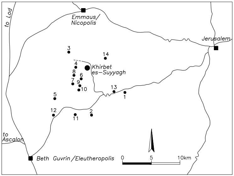
Map of the northern Judaean Hills and Shephelah, showing cities, main roads and main Christian sites in the vicinity of Khirbet es-Suyyagh
Taxel et al (2009) |
Fig. 10.1 - Taxel et al (2009) |
| Description | Image | Source |
|---|---|---|
| Monasteries in the Desert of Jerusalem Early Arab Period |
 Map
MapMap of monasteries in the Desert of Jerusalem (from Y. Hirschfeld, The Judean Desert Monasteries, Map. 1). The underlined sites are the monasteries that survived the Early Arab period. Patrich (2011) |
Map - Patrich (2011) |
| Judean Desert |
 Fig. 1
The route of Euthymius in the Judean Desert. Hirschfeld (1993) |
Fig. 1 - Hirschfeld (1993) |
| Location map of the monastery of Euthymius |
 Fig. 2
Location map of the monastery of Euthymius Hirschfeld (1993) |
Fig. 2 - Hirschfeld (1993) |
| Satellite monasteries around the monastery of Euthymius |
 Fig. 3
Satellite monasteries around the monastery of Euthymius Hirschfeld (1993) |
Fig. 3 - Hirschfeld (1993) |
| Description | Image | Source |
|---|---|---|
| Coastal Palestine 644-800 CE |
 Fig. 1
Location map ■ = urban/semi-urban/military settlement • = rural settlement Taxel (2013) |
Fig. 1 - Taxel (2013) |
| Early Islamic Palestine |
 Figure 1
Location map I. Taxel; N. Zak, Israel Antiquities Authority Taxel (2019) |
Fig. 1 - Taxel (2019) |
| Provincial Borders of the ajnad |
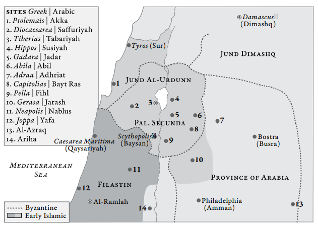 Figure 3
Map showing the rearrangement of provincial borders with the formation of the ajnad Walmsley (2007) |
Fig. 3 - Walmsley (2007) |
| E Mediterranean - early 8th century |
 Figure 1
The east Mediterranean in the early eighth century, showing principal sites mentioned in the text Walmsley (2007) |
Fig. 3 - Walmsley (2007) |
| Late Roman and Early Islamic provincs |
Map of the territories around Baysān/Scythopolis, Fiḥl/Pella and Jarash/Gerasa, showing late Roman and early Islamic provincial structures (Alan Walmsley). Blanke and Walmsley (2022) |
Fig. 4.1 - Blanke and Walmsley (2022) |
| Description | Image | Source |
|---|---|---|
| Sites along the Incense Road |
 Fig. 1
Sites along the Incense Road between Petra and Gaza with an inset of levantine trade routes. (Courtesy of the Israel Antiquities Authority.) Erickson-Gini and Israel (2013) |
Fig. 1 - Erickson-Gini and Israel (2013) |
| The Incense Road |
 Fig. 1a
The segment of the Incense road between Petra and Gaza. This segment was compiled using Tsafrir et al.(1994); McCormick (2008) and the locations of Roman milestones (Meshel and Tsafrir 1974, Ben-David 2018 – Person. comm.). Note also the Darb es-Sultan route north of the Incense Road compiled using the maps by Newcombe (1914) and Armstrong (1890)(Figure 2), rectified to the UTM zone 36 N (datum WGS84) Coordinate Reference System (CRS). Zohar and Erickson-Gini (2019) |
Fig. 1a - Zohar and Erickson-Gini (2019) |
| North Incense Road |
 Fig. 4c
LCP (Least Cost Path) models as potential routes of the Incense Road: Models A1, A2, and B-D representing route analyses between Petra and Oboda. Zohar and Erickson-Gini (2019) |
Fig. 4c - Zohar and Erickson-Gini (2019) |
| Central Incense Road |
 Fig. 4b
LCP (Least Cost Path) models as potential routes of the Incense Road: Model E representing route analyses between Oboda and Elusa. Zohar and Erickson-Gini (2019) |
Fig. 4b - Zohar and Erickson-Gini (2019) |
| South Incense Road |
 Fig. 4a
LCP (Least Cost Path) models as potential routes of the Incense Road: Model F representing route analyses between Elusa and Gaza. Zohar and Erickson-Gini (2019) |
Fig. 4a - Zohar and Erickson-Gini (2019) |
| The region between Sha’ar Ramon and Oboda |
 Fig. 5
The region between Sha’ar Ramon and Oboda, where milestones exist. Path Distance LCP model using the slope and distance to water resources as factors are portrayed in blue while the model using only the slope is portrayed in red. Note the similarity of the blue line to the path marked by the milestones except at the Grafon Fort. Zohar and Erickson-Gini (2019) |
Fig. 5 - Zohar and Erickson-Gini (2019) |
| Roman Roads |
 Fig. 2c
The network of Roman roads following Tsafrir et al.(1994) and McCormick (2008). Zohar and Erickson-Gini (2019) |
Fig. 2c - Zohar and Erickson-Gini (2019) |
| The Road to Oboda |
 Fig. 2a
Armstrong’s map portraying the road from the east (noted by arrows) leading to Oboda (Armstrong 1890) Zohar and Erickson-Gini (2019) |
Fig. 2a - Zohar and Erickson-Gini (2019) |
| Map of Roman castella and roads |
 Fig. 2
Map of Roman castella and roads (Alt 1935: 24), showing the location of ‘Barsama’ in the upper left corner Dolinka (2007) |
Fig. 2 - Dolinka (2007) |
| Description | Image | Source |
|---|---|---|
| Jerusalems Historical Basin |
 Main Archeological Sites In Jerusalems Historical Basin
Emek Shaveh (2017) |
Emek Shaveh (2017) The Temple Mount/Haram al-Sharif Archaeology in a Political Context |
| Temple Mount |
 Main Ancient Sites On The Temple Mount Al Haram Al Sharif And Its Surrounding
Emek Shaveh (2017) |
Emek Shaveh (2017) The Temple Mount/Haram al-Sharif Archaeology in a Political Context |
| Silwan |
 Archeological Areas In Silwan
Emek Shaveh (2017) |
Emek Shaveh (2017) The Temple Mount/Haram al-Sharif Archaeology in a Political Context |
| Temple Mount |

Map of the Temple Mount/Haram al-Sharif with numbered features mentioned in this paper:
(drawing: Gibson) Gibson (2020) |
Fig. 2 - Gibson (2020) |
| Silwan |
Archeological Areas In Silwan
Emek Shaveh (2017) |
Emek Shaveh (2017) The Temple Mount/Haram al-Sharif Archaeology in a Political Context |
| Haram - Umayyad Period |

THE HARAM IN JERUSALEM DURING THE UMAYYAD PERIOD Elad (1995) |
Map 1 - Elad (1995) |
| Inset to Map 1 |
 Map 1a
Inset to Map 1 Elad (1995) |
Map 1a - Elad (1995) |
| Legend to Map 1 and 1a |
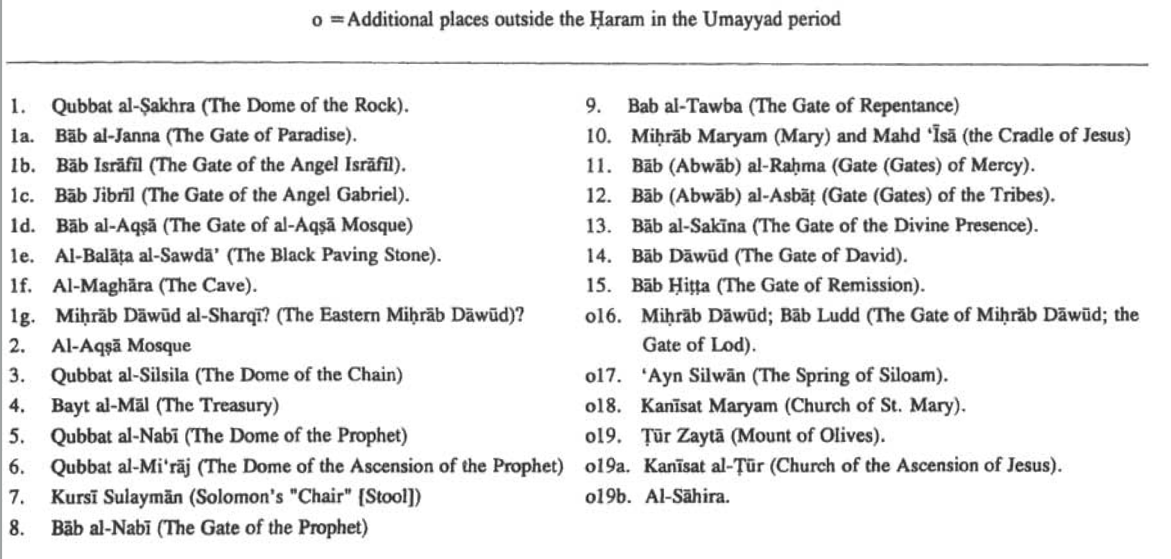 Legend to Map 1 and Map 1a
Elad (1995) |
Map 1 and 1a Legend - Elad (1995) |
| Haram - Muslim Pilgrimmage - ~1050 CE |
 Map 2
Map 2THE ITINERARY OF THE MUSLIM PILGRIM TO THE HOLY PLACES OF JERUSALEM ACCORDING TO IBN AL-MURALIA (Beginning and Mid-11th century)
Elad (1995) |
Map 2 - Elad (1995) |
| Inset to Map 2 |
 Map 2a
Inset to Map 2 Elad (1995) |
Map 2a - Elad (1995) |
| Legend to Map 2 and 2a |
 Map 2 and 2a Legend
Elad (1995) |
Map 2 Legend - Elad (1995) |
| Jerusalem - 638-1099 CE |
 Map 3
Map 3JERUSALEM DURING THE EARLY MUSLIM PERIOD (638-1099) Elad (1995) |
Map 3 - Elad (1995) |
| Map 3 Legend |
 Map 3 Legend
Based on Dan Bahat's map "Jerusalem During the Early Muslim Period-Sites Within the Old City". in The History of Jerusalem.. The Early Islamic Period (638-1099), Jerusalem, Yad Izlhak Ben-Zvi Publications, 1987 Elad (1995) |
Map 3 Legend - Elad (1995) |
Castles
Churches, Synagogues, and Mosques
Exploration
- Horvat Tov in Google Earth
 Horvat Tov
click on image to explore this site on a new tab in Google Earth - Horvat Tov on govmap.gov.il
 Horvat Tov
click on image to explore this site on a new tab in govmap.gov.il - Unexcavated Fortress (?) just
N of Horvat Tov on govmap.gov.il
 Unexcavated Fortress (?) just N of Horvat Tov
click on image to explore this site on a new tab in govmap.gov.il