Dor
 Aerial Panorama of Tel Dor from the southeast
Click on Image for high resolution magnifiable image
Drone photos taken by Jefferson Williams on 26 June 2023
| Transliterated Name | Source | Name |
|---|---|---|
| Dor | Hebrew | דוֹר |
| Tel Dor | Hebrew | דאר |
| Dora | Greek | Δῶρα |
| Tell el-Burj | Arabic | |
| Khirbet el-Burj | Arabic | |
| al-Tantura (adjacent) | Arabic | الطنطورة |
| Dir | Late Egyptian (Story of Wenamun) |
- Annotated Satellite Image
(google) of Tel Dor from biblewalks.com
- Annotated Aerial View of
Tel Dor and vicinity from Yasur-Landau et al. (2024)
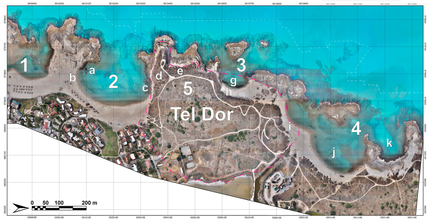
Figure 2
Tel Dor, its bays and location of main features mentioned in this article:
- Tantura Lagoon
- South Bay
- Love Bay
- North Bay
- Tel Dor (note dashed line for the current boundaries of the Tel)
Main features:
- Area T, submerged Hellenistic fortification
- Tombolo, FDEM survey and possible tower
- Iron Age submerged fortification and mole
- Area D, Iron Age and Hellenistic structures
- Coastal Roman temples
- Slipways/shipsheds
- Love Bay underwater excavations
- Love Bay land excavations and Hellenistic structures
- North Bay Roman rectangular structure
- Area X, submerged Roman mole
- Area W, Roman and earlier anchorage
(prepared by M. Runjajić, A. Tamberino and A. Yasur-Landau)
Yasur-Landau et al. (2024) - Dor in Google Earth
 Dor
Dor
click on image to explore this site on a new tab in Google Earth - Dor on govmap.gov.il
 Dor
Dor
click on image to explore this site on a new tab in govmap.gov.il

- Annotated Aerial View of
Tel Dor and vicinity from Yasur-Landau et al. (2024)
Figure 2
Tel Dor, its bays and location of main features mentioned in this article:
- Tantura Lagoon
- South Bay
- Love Bay
- North Bay
- Tel Dor (note dashed line for the current boundaries of the Tel)
Main features:
- Area T, submerged Hellenistic fortification
- Tombolo, FDEM survey and possible tower
- Iron Age submerged fortification and mole
- Area D, Iron Age and Hellenistic structures
- Coastal Roman temples
- Slipways/shipsheds
- Love Bay underwater excavations
- Love Bay land excavations and Hellenistic structures
- North Bay Roman rectangular structure
- Area X, submerged Roman mole
- Area W, Roman and earlier anchorage
(prepared by M. Runjajić, A. Tamberino and A. Yasur-Landau)
Yasur-Landau et al. (2024)
- Plan of Tel Dor from
Stern et al (1993)
 Tel Dor: plan of the mound and excavation areas.
Stern et al (1993) - Maritime installations near
the mound of Tel Dor from Stern et al (1993)
 Tel Dor: map of maritime installations near the mound.
- Northern anchorage
- Roman theater
- Storerooms and quay
- Upper-level flushing channel
- Lower-level flushing channel
- Soaking installation for dying cloth with purple
- Central anchorage
- Slipways, Persian period
- Large retaining structure
- Tel Dor
- Acropolis
- Wave trap and rock-cut fish ponds
- LB and Iron I quays
- Southern harbor
Stern et al (1993) - Map of Tel Dor from
Gilboa et. al. (2018 v. IIA) - with excavation areas
 Fig. 1.1
Map of Tel Dor showing Area G in relation to other excavation areas
(d09Z1-1001)
Gilboa et. al. (2018 v. IIA) - Map of Tel Dor from
Gilboa et. al. (2018 v. IIA) - The Roman Period
 Fig. 1.2
A reconstruction of the Roman street system at Dor, with Area G at the projected intersection of the north–south and east–west streets
(Shalev 2008: Fig. 24)
(d09Z1-1002)
Gilboa et. al. (2018 v. IIA)
- Plan of Tel Dor from
Stern et al (1993)
Tel Dor: plan of the mound and excavation areas.
Stern et al (1993) - Maritime installations near
the mound of Tel Dor from Stern et al (1993)
Tel Dor: map of maritime installations near the mound.
- Northern anchorage
- Roman theater
- Storerooms and quay
- Upper-level flushing channel
- Lower-level flushing channel
- Soaking installation for dying cloth with purple
- Central anchorage
- Slipways, Persian period
- Large retaining structure
- Tel Dor
- Acropolis
- Wave trap and rock-cut fish ponds
- LB and Iron I quays
- Southern harbor
Stern et al (1993) - Map of Tel Dor from
Gilboa et. al. (2018 v. IIA) - with excavation areas
Fig. 1.1
Map of Tel Dor showing Area G in relation to other excavation areas
(d09Z1-1001)
Gilboa et. al. (2018 v. IIA) - Map of Tel Dor from
Gilboa et. al. (2018 v. IIA) - The Roman Period
Fig. 1.2
A reconstruction of the Roman street system at Dor, with Area G at the projected intersection of the north–south and east–west streets
(Shalev 2008: Fig. 24)
(d09Z1-1002)
Gilboa et. al. (2018 v. IIA)
- Plan of Phase 7 in Area G
from Gilboa et. al. (2018 v. IIA)
 Plan 7
Phase 7
(d10Z1-1118)
Gilboa et. al. (2018 v. IIA) - Plan of Phase 9 in Area G
from Gilboa et. al. (2018 v. IIA)
 Plan 5
Phase 9
(d10Z1-1116)
Gilboa et. al. (2018 v. IIA) - Section of East Balk in
Area G from Gilboa et. al. (2018 v. IIA)
 Section 1
East balk, AI/31–32
(d09Z3-1225)
Gilboa et. al. (2018 v. IIA) - Fig. 2.1 - Superposition of Phases 9–6
in Area G from Gilboa et. al. (2018 v. IIA)
 Fig. 2.1
Superposition of Phases 9–6.
(d09Z3-1287)
Gilboa et. al. (2018 v. IIA) - Fig. 3.2 - Axonometric Superposition of
Phases 9-6 in Area G from Gilboa et. al. (2018 v. IIA)
 Fig. 3.2
An axonometric superposition of Phases 6–9, showing the continuity of wall sequences in the Area G house.
(d10Z1-1011)
Gilboa et. al. (2018 v. IIA) - Fig. 2.56 - Phase 7 schematic plan
from Gilboa et. al. (2018 v. IIA)
 Fig. 2.56
Phase 7, schematic plan.
(d09Z3-1314)
Gilboa et. al. (2018 v. IIA) - Fig. 2.45 - Phase 9 schematic plan
from Gilboa et. al. (2018 v. IIA)
 Fig. 2.45
Phase 9, schematic plan
(d10Z1-1009)
Gilboa et. al. (2018 v. IIA) - Fig. 2.22 - Plan of the Phase 9 courtyard
house from Gilboa et. al. (2018 v. IIA)
 Fig. 2.22
Plan of the Phase 9 house, with rooms and possible accessways.
(d09Z3-1447)
Gilboa et. al. (2018 v. IIA) - Fig. 2.30 - Phase 9-6 wall alignments
from Gilboa et. al. (2018 v. IIA)
 Fig. 2.30
- The conceptual grid along which most walls and spaces in the house are aligned
- Superposition of Phases 9-6 walls imposed on the grid
See Fig. 2.1 for key to phases.
(d09Z3-1297)
Gilboa et. al. (2018 v. IIA) - Fig. 2.54 - Artist's depiction of Phase
9 Courtyard House immediately before destruction from Gilboa et. al. (2018 v. IIA)
 Fig. 2.54
An artist's view of Phase 9, showing a suggestion of the rooms' functions based on their contents when destroyed, looking north
Drawing: T. Kurz, based on an earlier drawing by V. Damov.
(d09Z3-1288))
Gilboa et. al. (2018 v. IIA)
- Plan of Phase 7 in Area G
from Gilboa et. al. (2018 v. IIA)
Plan 7
Phase 7
(d10Z1-1118)
Gilboa et. al. (2018 v. IIA) - Plan of Phase 9 in Area G
from Gilboa et. al. (2018 v. IIA)
Plan 5
Phase 9
(d10Z1-1116)
Gilboa et. al. (2018 v. IIA) - Section of East Balk in
Area G from Gilboa et. al. (2018 v. IIA)
Section 1
East balk, AI/31–32
(d09Z3-1225)
Gilboa et. al. (2018 v. IIA) - Fig. 2.1 - Superposition of Phases 9–6
in Area G from Gilboa et. al. (2018 v. IIA)
Fig. 2.1
Superposition of Phases 9–6.
(d09Z3-1287)
Gilboa et. al. (2018 v. IIA) - Fig. 3.2 - Axonometric Superposition of
Phases 9-6 in Area G from Gilboa et. al. (2018 v. IIA)
Fig. 3.2
An axonometric superposition of Phases 6–9, showing the continuity of wall sequences in the Area G house.
(d10Z1-1011)
Gilboa et. al. (2018 v. IIA) - Fig. 2.56 - Phase 7 schematic plan
from Gilboa et. al. (2018 v. IIA)
Fig. 2.56
Phase 7, schematic plan.
(d09Z3-1314)
Gilboa et. al. (2018 v. IIA) - Fig. 2.45 - Phase 9 schematic plan
from Gilboa et. al. (2018 v. IIA)
Fig. 2.45
Phase 9, schematic plan
(d10Z1-1009)
Gilboa et. al. (2018 v. IIA) - Fig. 2.22 - Plan of the Phase 9 courtyard
house from Gilboa et. al. (2018 v. IIA)
Fig. 2.22
Plan of the Phase 9 house, with rooms and possible accessways.
(d09Z3-1447)
Gilboa et. al. (2018 v. IIA) - Fig. 2.30 - Phase 9-6 wall alignments
from Gilboa et. al. (2018 v. IIA)
Fig. 2.30
- The conceptual grid along which most walls and spaces in the house are aligned
- Superposition of Phases 9-6 walls imposed on the grid
See Fig. 2.1 for key to phases.
(d09Z3-1297)
Gilboa et. al. (2018 v. IIA) - Fig. 2.54 - Artist's depiction of Phase
9 Courtyard House immediately before destruction from Gilboa et. al. (2018 v. IIA)
Fig. 2.54
An artist's view of Phase 9, showing a suggestion of the rooms' functions based on their contents when destroyed, looking north
Drawing: T. Kurz, based on an earlier drawing by V. Damov.
(d09Z3-1288))
Gilboa et. al. (2018 v. IIA)
 Figure 6a
The locations of the cores [6a] and diagram of the chrono-stratigraphy [6b] of the coast of Dor, including Core D.
The OSL dates of the sediments in each core were used to reconstructs coastlines in the Hellenistic and Roman Periods (Figure 7). (Kadosh et al., 2004) and Cores D8, D11, D6, D12 and D4
(Shtienberg et al., 2021)
(prepared by G. Shtienberg, A. Tamberino and M. Runjajić)
Yasur-Landau et al. (2024)
 Figure 6b
The locations of the cores [6a] and diagram of the chrono-stratigraphy [6b] of the coast of Dor, including Core D.
The OSL dates of the sediments in each core were used to reconstructs coastlines in the Hellenistic and Roman Periods (Figure 7). (Kadosh et al., 2004) and Cores D8, D11, D6, D12 and D4
(Shtienberg et al., 2021)
(prepared by G. Shtienberg, A. Tamberino and M. Runjajić)
Yasur-Landau et al. (2024)
- Fig. 1 Geological sketch of
the eastern Mediterranean from Shtienberg et al (2020)

Fig. 1
Geological sketch of the eastern Mediterranean modified after natural earth, showing
- main near-shore sediment transport mechanism (black arrows)
- selected thrusts (CA–Cypriot Arc)
- major fault lines
- CF- Carmel fault
- DSF- Dead Sea Fault system
- SF- Seraghaya fault
- MF-Missyaf fault
- YF-Yammaounch fault
- [3,8]
- submarine landslides
- tsunami deposits
- geomorphological tsunami features
- documented tsunami events
- (Modified from [9])
NAME COMPILATION OF THE SITES PRESENTED IN THE FIGURE
Previously dated tsunami deposits
- 1a -2a (Alexandria)
- 3a (Paphos, Polis, Cape, Greco)
- 4a -8a (Caesarea Marittima, Jiser al-Zarka)
- 9a (Byblos, Senani Island)
- 10a (Elos)
- 11a (Gramvousa, Balos, Falasarna, Mavros, Stomiou, Gramenos, Paleochora)
- 12a (Western Crete)
- 13a (Palaikastro)
- 14a (Pounta)
- 15a (Limni Moustou)
- 16a (Pylos, Porto Gatea, Archangelos, Elaphonisos)
- 17a (Limni Divariou)
- 18a (Santorini)
- 19a (Balos bay)
- 20a (Thera)
- 21a (Dalaman)
- 22a (Didim) for the previously dated tsunami deposits
Previously dated tsunami events
- 1 (Lebanon, Israel, Syria)
- 2 (levant coast)
- 3 (Paphos, Polis, Cape, Greco)
- 4 (S-E Cyprus)
- 5 (Akko)
- 6 (Yaffo)
- 7–8 (S-E Cyprus)
- 9–11 (Levant coast)
- 12 (The Nile cone)
- 13 (Lebanon)
- 14 (Levant coast)
- 15 (southern turkey)
- 16 (Cyprus)
- 17 (Israel)
- 18 (Lebanon–Israel
Further details regarding the tsunami data are discussed in S1 and S2 Tables.
Shtienberg et al (2020) - Location Maps from
Shtienberg et al (2020)

Fig. 2
Location maps
(a) Israel’s Carmel coastal plain: surface lithologies, streams, shelf bathymetry and elevations (Republished from [14] under a CC BY license, with permission from [the geological Survey of Israel], original copyright [1994]). The red and green triangles indicate location of Neolithic habitations based on Galili et al. [15] while the red square annotates the location of the study area. The numbered red circles represent previously studied zones in which the stratigraphic sequence was investigated and is described in the following papers according to their numbering: (1) Kadosh et al. [16]; (2) Sivan et al. [16]. The numbered hexagons annotate prehistoric sites
- Nahal Oren (Natufian period)
- Elwad (Natufian period)
- Kebara (Natufian period)
- Tel Mevorakh (PPNB period)
- Aviel (late PPNB-PPNC period)
The projected coastline during the tsunami at ca 9,910–9,290 ya ca. 9.91–9.29 ka, is presumed to have been located between at about 40 to 16 m below present day sea-level and 3.5–1.5 km west of the current shoreline.
(b) The coast of Dor with existing cores and new drilling locations as well as elevations.
Shtienberg et al (2020) - Neolithic remains and construction
uncovered underwater from Shtienberg et al (2020)
 Fig. 6
Neolithic remains and construction uncovered underwater in the south bay of Dor during joint excavations conducted by the Department of Maritime Civilizations at the University of Haifa and Scripps Center of Marine Archeology at the University of California San Diego
- location of the findings marked by red polygons—each letter is attributed to the finds presented in the next parts of the figure
- Pre pottery Neolithic–Early Pottery Neolithic arrowhead
- Neolithic architecture which includes curved installations as well as wall foundations
- Pottery Neolithic ceramic base excavated in 2019 by the Department of Maritime Civilizations, University of Haifa
Shtienberg et al (2020) - Longshore Current on the
Israeli Coast from Morhange et. al. (2016)
 Fig. 1
Location map. Akko (Northern Israel) in the Eastern Mediterranean basin.
Morhange et. al. (2016)
- Fig. 2.58 - Skeleton of a
woman in Room 9816 from Gilboa et. al. (2018 v. IIA)
 Fig. 2.58
The skeleton of a woman in Room 9816, looking south, partly covered by fallen stones.
(p08Z3-1013)
Gilboa et. al. (2018 v. IIA) - Fig. 5.2 - "Doreen" the
skeleton in Phase 7 from Nur and Burgess (2008)
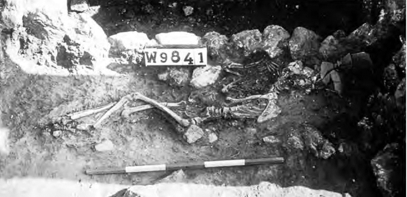 Fig. 5.2
“Doreen,” a probable earthquake victim at Dor in Israel, was crushed by a fallen wall .
(after Andrew Stewart/Biblical Archaeology Review, 1993)
Nur and Burgess (2008) - Fig. 10.10 - Wider shot
of the skeleton with remaining stone collapse on skull from Gilboa et. al. (2018 v. IIA)
 Fig. 10.10
The skeleton against W9841 after partial clearance, looking south. Note remaining stone collapse above skull.
(p08Z3-1248)
Gilboa et. al. (2018 v. IIA) - Fig. 10.11 - Almost
completely exposed skeleton from Gilboa et. al. (2018 v. IIA)
 Fig. 10.11
The almost completely exposed skeleton, looking west.
(p08Z3-1249)
Gilboa et. al. (2018 v. IIA) - Fig. 2.59 - Smashed
pottery and rubble collapse in Room 9816 from Gilboa et. al. (2018 v. IIA)
 Fig. 2.59
Smashed pottery and rubble collapse on F9816, looking north
(photograph courtesy of Andrew Stewart)
(p10Z3-0059)
Gilboa et. al. (2018 v. IIA) - Fig. 10.6 - Stone
Collapse which covered the skeleton along with smashed jars from Gilboa et. al. (2018 v. IIA)
 Fig. 10.6
Corner of W9211 and W9684, looking north. Northern thicker part of the stone collapse (L9816) that covered the skeleton and the smashed jars (some of which are showing below the meter stick).
(p08Z3-1250)
Gilboa et. al. (2018 v. IIA) - Fig. 10.7 - Pottery
found in wall collapse debris, suggesting material stored on a shelf from Gilboa et. al. (2018 v. IIA)
 Fig. 10.7
Pottery found in wall collapse debris on F9816, suggesting material stored on a shelf
(photograph courtesy of Andrew Stewart)
(p10Z3-0078)
Gilboa et. al. (2018 v. IIA)
- Fig. 2.58 - Skeleton of a
woman in Room 9816 from Gilboa et. al. (2018 v. IIA)
Fig. 2.58
The skeleton of a woman in Room 9816, looking south, partly covered by fallen stones.
(p08Z3-1013)
Gilboa et. al. (2018 v. IIA) - Fig. 5.2 - "Doreen" the
skeleton in Phase 7 from Nur and Burgess (2008)
Fig. 5.2
“Doreen,” a probable earthquake victim at Dor in Israel, was crushed by a fallen wall .
(after Andrew Stewart/Biblical Archaeology Review, 1993)
Nur and Burgess (2008) - Fig. 10.10 - Wider shot
of the skeleton with remaining stone collapse on skull from Gilboa et. al. (2018 v. IIA)
Fig. 10.10
The skeleton against W9841 after partial clearance, looking south. Note remaining stone collapse above skull.
(p08Z3-1248)
Gilboa et. al. (2018 v. IIA) - Fig. 10.11 - Almost
completely exposed skeleton from Gilboa et. al. (2018 v. IIA)
Fig. 10.11
The almost completely exposed skeleton, looking west.
(p08Z3-1249)
Gilboa et. al. (2018 v. IIA) - Fig. 2.59 - Smashed
pottery and rubble collapse in Room 9816 from Gilboa et. al. (2018 v. IIA)
Fig. 2.59
Smashed pottery and rubble collapse on F9816, looking north
(photograph courtesy of Andrew Stewart)
(p10Z3-0059)
Gilboa et. al. (2018 v. IIA) - Fig. 10.6 - Stone
Collapse which covered the skeleton along with smashed jars from Gilboa et. al. (2018 v. IIA)
Fig. 10.6
Corner of W9211 and W9684, looking north. Northern thicker part of the stone collapse (L9816) that covered the skeleton and the smashed jars (some of which are showing below the meter stick).
(p08Z3-1250)
Gilboa et. al. (2018 v. IIA) - Fig. 10.7 - Pottery
found in wall collapse debris, suggesting material stored on a shelf from Gilboa et. al. (2018 v. IIA)
Fig. 10.7
Pottery found in wall collapse debris on F9816, suggesting material stored on a shelf
(photograph courtesy of Andrew Stewart)
(p10Z3-0078)
Gilboa et. al. (2018 v. IIA)
- Fig. 2.12 - Phase 9
destruction debris in Room 18033 from Gilboa et. al. (2018 v. IIA)
 Fig. 2.12
Section through the Phase 9 destruction debris in Room 18033, looking west. Note in situ jars on floor, with mudbrick and stone collapse on top and burnt beams and roofing material above
(photograph courtesy of J.C. Monroe)
(p09Z3-6011)
Gilboa et. al. (2018 v. IIA) - Fig. 2.13 - Closeup
on burnt roof material in Phase 9 destruction layer from Gilboa et. al. (2018 v. IIA)
 Fig. 2.13
Close-up of roof collapse seen in section in Fig. 2.12. Above the beams: burnt organic layer with packing of mudbrick material above
(photograph courtesy of J.C. Monroe)
(p09Z3-6014)
Gilboa et. al. (2018 v. IIA) - Fig. 2.14 - Closeup
on collapsed roof material in Phase 9 destruction layer from Gilboa et. al. (2018 v. IIA)
 Fig. 2.14
Close-up of roof collapse in western balk in Room 18033, opposite the roofing material in Figs. 2.12 and 2.13. Note the two cross-members under the brush and a thin white organic layer (mat? fronds?) draping across them
(photograph courtesy of J.C. Monroe)
(p08Z3-1460)
Gilboa et. al. (2018 v. IIA) - Fig. 2.26 - Phase 9
collapse debris from Gilboa et. al. (2018 v. IIA)
 Fig. 2.26
Collapsed debris tumbled against installation 9982 (on right), looking north. Center and left: fallen stones and mudbrick below three layers of fallen ceiling material (=Fig. 9.39).
(p05Z3-0610)
Gilboa et. al. (2018 v. IIA) - Fig. 2.46 - Phase 9
destruction layer from Gilboa et. al. (2018 v. IIA)
 Fig. 2.46
Area G destruction as first encountered in 1992, looking west. Center: narrow partition belonging to southeastern edge of trough-installation 9982, not yet fully exposed (=Fig. 9.41)
(p08Z3-1004)
Gilboa et. al. (2018 v. IIA) - Fig. 2.47 - Phase 9
destruction layer as seen in a balk from Gilboa et. al. (2018 v. IIA)
 Fig. 2.47
View of eastern balk, AI/32, showing the depth of Phase 9 destruction debris; the arrow marks the top of the destruction material. Square supervisor Robyn Talman standing on courtyard floor
(photograph courtesy of Andrew Stewart)
(p08Z3-1440)
Gilboa et. al. (2018 v. IIA) - Fig. 2.48 - Broken
Pottery in Phase 9 from Gilboa et. al. (2018 v. IIA)
 Fig. 2.48
In situ pottery near the trough-installation, looking west. Note basalt bowl, upper grinding stone (above meter stick) and "stone tripod" at bottom (=Fig. 9.47).
(p09z3-6007)
Gilboa et. al. (2018 v. IIA) - Fig. 2.49 - Broken
Pottery on the floor of Room 18033 in Phase 9 destruction layer from Gilboa et. al. (2018 v. IIA)
 Fig. 2.49
Jars in destruction on Phase 9 floor in Room 18033, looking west (=Fig. 8.29).
(p08Z3-1459)
Gilboa et. al. (2018 v. IIA) - Fig. 2.50 - Phase 9
destruction layer in Room 18239 from Gilboa et. al. (2018 v. IIA)
 Fig. 2.50
F18239 under excavation, looking south. Note slope of surface, with in situ pottery and deer antler.
(p08Z3-1007)
Gilboa et. al. (2018 v. IIA) - Fig. 3.16 - Phase 9
destruction east of Wall 18048 from Gilboa et. al. (2018 v. IIA)
 Fig. 3.16
W9140(S) above W18048 (AJ/32), looking north. Note destruction debris with fallen bricks and roofing material in the probe east of W18048
(photo courtesy of Andrew Stewart).
(p10Z3-0017)
Gilboa et. al. (2018 v. IIA) - Fig. 15.18 - Annotated
balk showing section of Phase 9 mudbrick collapse from Gilboa et. al. (2018 v. IIA)
 Fig. 15.180
The northern balk of AJ–AK/32 under W9066, after end of excavation (2004).
(p05Z3-0727)
Gilboa et. al. (2018 v. IIA)
- Fig. 2.12 - Phase 9
destruction debris in Room 18033 from Gilboa et. al. (2018 v. IIA)
Fig. 2.12
Section through the Phase 9 destruction debris in Room 18033, looking west. Note in situ jars on floor, with mudbrick and stone collapse on top and burnt beams and roofing material above
(photograph courtesy of J.C. Monroe)
(p09Z3-6011)
Gilboa et. al. (2018 v. IIA) - Fig. 2.13 - Closeup
on burnt roof material in Phase 9 destruction layer from Gilboa et. al. (2018 v. IIA)
Fig. 2.13
Close-up of roof collapse seen in section in Fig. 2.12. Above the beams: burnt organic layer with packing of mudbrick material above
(photograph courtesy of J.C. Monroe)
(p09Z3-6014)
Gilboa et. al. (2018 v. IIA) - Fig. 2.14 - Closeup
on collapsed roof material in Phase 9 destruction layer from Gilboa et. al. (2018 v. IIA)
Fig. 2.14
Close-up of roof collapse in western balk in Room 18033, opposite the roofing material in Figs. 2.12 and 2.13. Note the two cross-members under the brush and a thin white organic layer (mat? fronds?) draping across them
(photograph courtesy of J.C. Monroe)
(p08Z3-1460)
Gilboa et. al. (2018 v. IIA) - Fig. 2.26 - Phase 9
collapse debris from Gilboa et. al. (2018 v. IIA)
Fig. 2.26
Collapsed debris tumbled against installation 9982 (on right), looking north. Center and left: fallen stones and mudbrick below three layers of fallen ceiling material (=Fig. 9.39).
(p05Z3-0610)
Gilboa et. al. (2018 v. IIA) - Fig. 2.46 - Phase 9
destruction layer from Gilboa et. al. (2018 v. IIA)
Fig. 2.46
Area G destruction as first encountered in 1992, looking west. Center: narrow partition belonging to southeastern edge of trough-installation 9982, not yet fully exposed (=Fig. 9.41)
(p08Z3-1004)
Gilboa et. al. (2018 v. IIA) - Fig. 2.47 - Phase 9
destruction layer as seen in a balk from Gilboa et. al. (2018 v. IIA)
Fig. 2.47
View of eastern balk, AI/32, showing the depth of Phase 9 destruction debris; the arrow marks the top of the destruction material. Square supervisor Robyn Talman standing on courtyard floor
(photograph courtesy of Andrew Stewart)
(p08Z3-1440)
Gilboa et. al. (2018 v. IIA) - Fig. 2.48 - Broken
Pottery in Phase 9 from Gilboa et. al. (2018 v. IIA)
Fig. 2.48
In situ pottery near the trough-installation, looking west. Note basalt bowl, upper grinding stone (above meter stick) and "stone tripod" at bottom (=Fig. 9.47).
(p09z3-6007)
Gilboa et. al. (2018 v. IIA) - Fig. 2.49 - Broken
Pottery on the floor of Room 18033 in Phase 9 destruction layer from Gilboa et. al. (2018 v. IIA)
Fig. 2.49
Jars in destruction on Phase 9 floor in Room 18033, looking west (=Fig. 8.29).
(p08Z3-1459)
Gilboa et. al. (2018 v. IIA) - Fig. 2.50 - Phase 9
destruction layer in Room 18239 from Gilboa et. al. (2018 v. IIA)
Fig. 2.50
F18239 under excavation, looking south. Note slope of surface, with in situ pottery and deer antler.
(p08Z3-1007)
Gilboa et. al. (2018 v. IIA) - Fig. 3.16 - Phase 9
destruction east of Wall 18048 from Gilboa et. al. (2018 v. IIA)
Fig. 3.16
W9140(S) above W18048 (AJ/32), looking north. Note destruction debris with fallen bricks and roofing material in the probe east of W18048
(photo courtesy of Andrew Stewart).
(p10Z3-0017)
Gilboa et. al. (2018 v. IIA) - Fig. 15.18 - Annotated
balk showing section of Phase 9 mudbrick collapse from Gilboa et. al. (2018 v. IIA)
Fig. 15.180
The northern balk of AJ–AK/32 under W9066, after end of excavation (2004).
(p05Z3-0727)
Gilboa et. al. (2018 v. IIA)
- Fig. 3 Chronostratigraphic cross
sections in the coastal area from Shtienberg et al (2020)

Fig. 3
Core analysis and chronostratigraphic correlation
(a) Borehole D4 with core scan
- lithological unit name
- sedimentological and petrophysical results
- lithological identification with OSL sampling location
- OSL ages presented before 2018
- corresponding sea level [23,24]
- approximate shoreline location
(b) Chronostratigraphic cross sections in the coastal area of Dor based on sedimentological and OSL data obtained in the present study, presented for thousand years ago (ka, marked with a red star) as well as Shtienberg et al. (submitted; blue star) correlated with the lithological results, and 14C calibrated dates (cal. ka; green circles) published in Kadosh et al. [16]. A closeup of units F2, F3 and F4 in core D6 with its lithological unit name and accumulative grain texture results. The modern topography portrayed in the cross sections was extracted from the DEM presented in Fig 2B. See Fig 2B for cross section location.
Shtienberg et al (2020) - Fig. 5 Age constraint for the
tsunami deposit from Shtienberg et al (2020)
 Fig. 5
Age constraint for the tsunami deposit (Unit F3) based on the ages and stratigraphic position of the lower wetland deposit (Unit F2) the abruptly overlying sandy tsunami deposit (Unit F3) and upper wetland deposit (Unit F4) that have been correlated between cores in the study area (Fig 3). The age constraint for the tsunami deposit (Unit F3) is based on the overlapping ages and uncertainties (highlighted by dashed red line) between the Unit F2 wetland deposit (green circle, core D6) the overlying Unit F3 tsunami deposit (yellow circle, core D4) and superimposing Unit F4 wetland deposit (blue circle, core D4).
Shtienberg et al (2020) - Fig. S1 Borehole D4 from
Shtienberg et al (2020)
 Fig. S1
Borehole D4 (location is displayed in Fig. 2b) with
- lithological classification
- description
- accompanying features
- brightness differences
- relative elemental concentration variations
- OSL data
obtained in the present study.
Shtienberg et al (2020) - Fig. S2 Borehole D6 from
Shtienberg et al (2020)
 Fig. S2
Borehole D6 (location is displayed in Fig. 2b) with
- lithological classification
- description
- accompanying features
- brightness differences
- relative elemental concentration variations
- OSL data
obtained in the present study.
Shtienberg et al (2020) - Fig. S3 Borehole D12 from
Shtienberg et al (2020)
 Fig. S3
Borehole D12 (location is displayed in Fig. 2b) with
- lithological classification
- description
- accompanying features
- brightness differences
- relative elemental concentration variations
- OSL data
obtained in the present study.
Shtienberg et al (2020) - Fig. S4 Equivalent Dose
distributions for OSL samples from Shtienberg et al (2020)
 Fig. S4
Equivalent Dose distributions for OSL samples
- CAM = Central Age Model
- OD = Over-dispersion
Shtienberg et al (2020)
- Fig. 3 Chronostratigraphic cross
sections in the coastal area from Shtienberg et al (2020)
Fig. 3
Core analysis and chronostratigraphic correlation
(a) Borehole D4 with core scan
- lithological unit name
- sedimentological and petrophysical results
- lithological identification with OSL sampling location
- OSL ages presented before 2018
- corresponding sea level [23,24]
- approximate shoreline location
(b) Chronostratigraphic cross sections in the coastal area of Dor based on sedimentological and OSL data obtained in the present study, presented for thousand years ago (ka, marked with a red star) as well as Shtienberg et al. (submitted; blue star) correlated with the lithological results, and 14C calibrated dates (cal. ka; green circles) published in Kadosh et al. [16]. A closeup of units F2, F3 and F4 in core D6 with its lithological unit name and accumulative grain texture results. The modern topography portrayed in the cross sections was extracted from the DEM presented in Fig 2B. See Fig 2B for cross section location.
Shtienberg et al (2020) - Fig. 5 Age constraint for the
tsunami deposit from Shtienberg et al (2020)
Fig. 5
Age constraint for the tsunami deposit (Unit F3) based on the ages and stratigraphic position of the lower wetland deposit (Unit F2) the abruptly overlying sandy tsunami deposit (Unit F3) and upper wetland deposit (Unit F4) that have been correlated between cores in the study area (Fig 3). The age constraint for the tsunami deposit (Unit F3) is based on the overlapping ages and uncertainties (highlighted by dashed red line) between the Unit F2 wetland deposit (green circle, core D6) the overlying Unit F3 tsunami deposit (yellow circle, core D4) and superimposing Unit F4 wetland deposit (blue circle, core D4).
Shtienberg et al (2020) - Fig. S1 Borehole D4 from
Shtienberg et al (2020)
Fig. S1
Borehole D4 (location is displayed in Fig. 2b) with
- lithological classification
- description
- accompanying features
- brightness differences
- relative elemental concentration variations
- OSL data
obtained in the present study.
Shtienberg et al (2020) - Fig. S2 Borehole D6 from
Shtienberg et al (2020)
Fig. S2
Borehole D6 (location is displayed in Fig. 2b) with
- lithological classification
- description
- accompanying features
- brightness differences
- relative elemental concentration variations
- OSL data
obtained in the present study.
Shtienberg et al (2020) - Fig. S3 Borehole D12 from
Shtienberg et al (2020)
Fig. S3
Borehole D12 (location is displayed in Fig. 2b) with
- lithological classification
- description
- accompanying features
- brightness differences
- relative elemental concentration variations
- OSL data
obtained in the present study.
Shtienberg et al (2020) - Fig. S4 Equivalent Dose
distributions for OSL samples from Shtienberg et al (2020)
Fig. S4
Equivalent Dose distributions for OSL samples
- CAM = Central Age Model
- OD = Over-dispersion
Shtienberg et al (2020)
- Fig. 1 Geological sketch of
the eastern Mediterranean from Shtienberg et al (2020)
Fig. 1
Geological sketch of the eastern Mediterranean modified after natural earth, showing
- main near-shore sediment transport mechanism (black arrows)
- selected thrusts (CA–Cypriot Arc)
- major fault lines
- CF- Carmel fault
- DSF- Dead Sea Fault system
- SF- Seraghaya fault
- MF-Missyaf fault
- YF-Yammaounch fault
- [3,8]
- submarine landslides
- tsunami deposits
- geomorphological tsunami features
- documented tsunami events
- (Modified from [9])
NAME COMPILATION OF THE SITES PRESENTED IN THE FIGURE
Previously dated tsunami deposits
- 1a -2a (Alexandria)
- 3a (Paphos, Polis, Cape, Greco)
- 4a -8a (Caesarea Marittima, Jiser al-Zarka)
- 9a (Byblos, Senani Island)
- 10a (Elos)
- 11a (Gramvousa, Balos, Falasarna, Mavros, Stomiou, Gramenos, Paleochora)
- 12a (Western Crete)
- 13a (Palaikastro)
- 14a (Pounta)
- 15a (Limni Moustou)
- 16a (Pylos, Porto Gatea, Archangelos, Elaphonisos)
- 17a (Limni Divariou)
- 18a (Santorini)
- 19a (Balos bay)
- 20a (Thera)
- 21a (Dalaman)
- 22a (Didim) for the previously dated tsunami deposits
Previously dated tsunami events
- 1 (Lebanon, Israel, Syria)
- 2 (levant coast)
- 3 (Paphos, Polis, Cape, Greco)
- 4 (S-E Cyprus)
- 5 (Akko)
- 6 (Yaffo)
- 7–8 (S-E Cyprus)
- 9–11 (Levant coast)
- 12 (The Nile cone)
- 13 (Lebanon)
- 14 (Levant coast)
- 15 (southern turkey)
- 16 (Cyprus)
- 17 (Israel)
- 18 (Lebanon–Israel
Further details regarding the tsunami data are discussed in S1 and S2 Tables.
Shtienberg et al (2020) - Location Maps from
Shtienberg et al (2020)
Fig. 2
Location maps
(a) Israel’s Carmel coastal plain: surface lithologies, streams, shelf bathymetry and elevations (Republished from [14] under a CC BY license, with permission from [the geological Survey of Israel], original copyright [1994]). The red and green triangles indicate location of Neolithic habitations based on Galili et al. [15] while the red square annotates the location of the study area. The numbered red circles represent previously studied zones in which the stratigraphic sequence was investigated and is described in the following papers according to their numbering: (1) Kadosh et al. [16]; (2) Sivan et al. [16]. The numbered hexagons annotate prehistoric sites
- Nahal Oren (Natufian period)
- Elwad (Natufian period)
- Kebara (Natufian period)
- Tel Mevorakh (PPNB period)
- Aviel (late PPNB-PPNC period)
The projected coastline during the tsunami at ca 9,910–9,290 ya ca. 9.91–9.29 ka, is presumed to have been located between at about 40 to 16 m below present day sea-level and 3.5–1.5 km west of the current shoreline.
(b) The coast of Dor with existing cores and new drilling locations as well as elevations.
Shtienberg et al (2020) - Neolithic remains and construction
uncovered underwater from Shtienberg et al (2020)
Fig. 6
Neolithic remains and construction uncovered underwater in the south bay of Dor during joint excavations conducted by the Department of Maritime Civilizations at the University of Haifa and Scripps Center of Marine Archeology at the University of California San Diego
- location of the findings marked by red polygons—each letter is attributed to the finds presented in the next parts of the figure
- Pre pottery Neolithic–Early Pottery Neolithic arrowhead
- Neolithic architecture which includes curved installations as well as wall foundations
- Pottery Neolithic ceramic base excavated in 2019 by the Department of Maritime Civilizations, University of Haifa
Shtienberg et al (2020) - Longshore Current on the
Israeli Coast from Morhange et. al. (2016)
Fig. 1
Location map. Akko (Northern Israel) in the Eastern Mediterranean basin.
Morhange et. al. (2016)
- Fig. 3 Chronostratigraphic cross
sections in the coastal area from Shtienberg et al (2020)
Fig. 3
Core analysis and chronostratigraphic correlation
(a) Borehole D4 with core scan
- lithological unit name
- sedimentological and petrophysical results
- lithological identification with OSL sampling location
- OSL ages presented before 2018
- corresponding sea level [23,24]
- approximate shoreline location
(b) Chronostratigraphic cross sections in the coastal area of Dor based on sedimentological and OSL data obtained in the present study, presented for thousand years ago (ka, marked with a red star) as well as Shtienberg et al. (submitted; blue star) correlated with the lithological results, and 14C calibrated dates (cal. ka; green circles) published in Kadosh et al. [16]. A closeup of units F2, F3 and F4 in core D6 with its lithological unit name and accumulative grain texture results. The modern topography portrayed in the cross sections was extracted from the DEM presented in Fig 2B. See Fig 2B for cross section location.
Shtienberg et al (2020) - Fig. 5 Age constraint for the
tsunami deposit from Shtienberg et al (2020)
Fig. 5
Age constraint for the tsunami deposit (Unit F3) based on the ages and stratigraphic position of the lower wetland deposit (Unit F2) the abruptly overlying sandy tsunami deposit (Unit F3) and upper wetland deposit (Unit F4) that have been correlated between cores in the study area (Fig 3). The age constraint for the tsunami deposit (Unit F3) is based on the overlapping ages and uncertainties (highlighted by dashed red line) between the Unit F2 wetland deposit (green circle, core D6) the overlying Unit F3 tsunami deposit (yellow circle, core D4) and superimposing Unit F4 wetland deposit (blue circle, core D4).
Shtienberg et al (2020) - Fig. S1 Borehole D4 from
Shtienberg et al (2020)
Fig. S1
Borehole D4 (location is displayed in Fig. 2b) with
- lithological classification
- description
- accompanying features
- brightness differences
- relative elemental concentration variations
- OSL data
obtained in the present study.
Shtienberg et al (2020) - Fig. S2 Borehole D6 from
Shtienberg et al (2020)
Fig. S2
Borehole D6 (location is displayed in Fig. 2b) with
- lithological classification
- description
- accompanying features
- brightness differences
- relative elemental concentration variations
- OSL data
obtained in the present study.
Shtienberg et al (2020) - Fig. S3 Borehole D12 from
Shtienberg et al (2020)
Fig. S3
Borehole D12 (location is displayed in Fig. 2b) with
- lithological classification
- description
- accompanying features
- brightness differences
- relative elemental concentration variations
- OSL data
obtained in the present study.
Shtienberg et al (2020) - Fig. S4 Equivalent Dose
distributions for OSL samples from Shtienberg et al (2020)
Fig. S4
Equivalent Dose distributions for OSL samples
- CAM = Central Age Model
- OD = Over-dispersion
Shtienberg et al (2020)
 Table 2.2 (aka Chart 2)
Area G Bronze and Iron Ages phases and horizons by context
- Small Roman numerals (i, ii, etc.): local stages within unit
- Thick separator between stages: evidence for destruction or trauma
- Asterisk (*): context fully illustrated (numbers above are plate nos. in Volume IIC)
- Arrows (↔): placement of the stage separator (or of the entire stage) is arbitrary; it might be moved right (later) or left (earlier)
Gilboa et. al. (2018 v. IIA)
 Table 2.1 (aka Chart 1)
Comparative stratigraphy and chronology of Areas G, D2, D5 and B1 and correlation to Megiddo strata
Gilboa et. al. (2018 v. IIA)
 Table 20.1
Radiometric determinations from Area G produced by liquid scintillation counting from charcoal samples
Gilboa et. al. (2018 v. IIB Ch. 20)
- Fig. 2.1
- Superposition of Phases 9–6 in Area G from Gilboa et. al. (2018 v. IIA)
Fig. 2.1
Superposition of Phases 9–6.
(d09Z3-1287)
Gilboa et. al. (2018 v. IIA) - Fig. 3.2
- Axonometric Superposition of Phases 9-6 in Area G from Gilboa et. al. (2018 v. IIA)
Fig. 3.2
An axonometric superposition of Phases 6–9, showing the continuity of wall sequences in the Area G house.
(d10Z1-1011)
Gilboa et. al. (2018 v. IIA) - Fig. 2.12
- Phase 9 destruction debris in Room 18033 from Gilboa et. al. (2018 v. IIA)
Fig. 2.12
Section through the Phase 9 destruction debris in Room 18033, looking west. Note in situ jars on floor, with mudbrick and stone collapse on top and burnt beams and roofing material above
(photograph courtesy of J.C. Monroe)
(p09Z3-6011)
Gilboa et. al. (2018 v. IIA) - Fig. 2.13
- Closeup on burnt roof material in Phase 9 destruction layer from Gilboa et. al. (2018 v. IIA)
Fig. 2.13
Close-up of roof collapse seen in section in Fig. 2.12. Above the beams: burnt organic layer with packing of mudbrick material above
(photograph courtesy of J.C. Monroe)
(p09Z3-6014)
Gilboa et. al. (2018 v. IIA) - Fig. 2.14
- Closeup on collapsed roof material in Phase 9 destruction layer from Gilboa et. al. (2018 v. IIA)
Fig. 2.14
Close-up of roof collapse in western balk in Room 18033, opposite the roofing material in Figs. 2.12 and 2.13. Note the two cross-members under the brush and a thin white organic layer (mat? fronds?) draping across them
(photograph courtesy of J.C. Monroe)
(p08Z3-1460)
Gilboa et. al. (2018 v. IIA) - Fig. 2.22
- Plan of the Phase 9 courtyard house from Gilboa et. al. (2018 v. IIA)
Fig. 2.22
Plan of the Phase 9 house, with rooms and possible accessways.
(d09Z3-1447)
Gilboa et. al. (2018 v. IIA) - Fig. 2.26
- Phase 9 collapse debris from Gilboa et. al. (2018 v. IIA)
Fig. 2.26
Collapsed debris tumbled against installation 9982 (on right), looking north. Center and left: fallen stones and mudbrick below three layers of fallen ceiling material (=Fig. 9.39).
(p05Z3-0610)
Gilboa et. al. (2018 v. IIA) - Fig. 2.29
- Phase 9 trough-installation in "courtyard" from Gilboa et. al. (2018 v. IIA)
 Fig. 2.29
Phase 9 trough-installation 9982 with bin 9805 and pavement F18087 to its left, looking north. Right: unpaved part of courtyard with "tripod" installation. Traces of fire clearly seen on both floor and installation.
(p08Z3-1010)
Gilboa et. al. (2018 v. IIA) - Fig. 2.30
- Phase 9 wall alignment from Gilboa et. al. (2018 v. IIA)
Fig. 2.30
- The conceptual grid along which most walls and spaces in the house are aligned
- Superposition of Phases 9-6 walls imposed on the grid
See Fig. 2.1 for key to phases.
(d09Z3-1297)
Gilboa et. al. (2018 v. IIA) - Fig. 2.45
- Phase 9 schematic plan from Gilboa et. al. (2018 v. IIA)
Fig. 2.45
Phase 9, schematic plan
(d10Z1-1009)
Gilboa et. al. (2018 v. IIA) - Fig. 2.46
- Phase 9 destruction layer from Gilboa et. al. (2018 v. IIA)
Fig. 2.46
Area G destruction as first encountered in 1992, looking west. Center: narrow partition belonging to southeastern edge of trough-installation 9982, not yet fully exposed (=Fig. 9.41)
(p08Z3-1004)
Gilboa et. al. (2018 v. IIA) - Fig. 2.47
- Phase 9 destruction layer as seen in a balk from Gilboa et. al. (2018 v. IIA)
Fig. 2.47
View of eastern balk, AI/32, showing the depth of Phase 9 destruction debris; the arrow marks the top of the destruction material. Square supervisor Robyn Talman standing on courtyard floor
(photograph courtesy of Andrew Stewart)
(p08Z3-1440)
Gilboa et. al. (2018 v. IIA) - Fig. 2.48
- Broken Pottery in Phase 9 from Gilboa et. al. (2018 v. IIA)
Fig. 2.48
In situ pottery near the trough-installation, looking west. Note basalt bowl, upper grinding stone (above meter stick) and "stone tripod" at bottom (=Fig. 9.47).
(p09z3-6007)
Gilboa et. al. (2018 v. IIA) - Fig. 2.49
- Broken Pottery on the floor of Room 18033 in Phase 9 destruction layer from Gilboa et. al. (2018 v. IIA)
Fig. 2.49
Jars in destruction on Phase 9 floor in Room 18033, looking west (=Fig. 8.29).
(p08Z3-1459)
Gilboa et. al. (2018 v. IIA) - Fig. 2.50
- Phase 9 destruction layer in Room 18239 from Gilboa et. al. (2018 v. IIA)
Fig. 2.50
F18239 under excavation, looking south. Note slope of surface, with in situ pottery and deer antler.
(p08Z3-1007)
Gilboa et. al. (2018 v. IIA) - Fig. 2.53
- The "basin" in Room 9928 (possible subsidence) from Gilboa et. al. (2018 v. IIA)
 Fig. 2.53
The "basin" in possible entryway in Room 9928, looking south
(photograph courtesy of Andrew Stewart)
(p09Z9-6009)
Gilboa et. al. (2018 v. IIA) - Fig. 2.54
- Artist's depiction of Phase 9 Courtyard House immediately before destruction from Gilboa et. al. (2018 v. IIA)
Fig. 2.54
An artist's view of Phase 9, showing a suggestion of the rooms' functions based on their contents when destroyed, looking north
Drawing: T. Kurz, based on an earlier drawing by V. Damov.
(d09Z3-1288))
Gilboa et. al. (2018 v. IIA)
Table 2.1 (aka Chart 1)Comparative stratigraphy and chronology of Areas G, D2, D5 and B1 and correlation to Megiddo strata
Gilboa et. al. (2018 v. IIA)
Table 2.2 (aka Chart 2)Area G Bronze and Iron Ages phases and horizons by context
- Small Roman numerals (i, ii, etc.): local stages within unit
- Thick separator between stages: evidence for destruction or trauma
- Asterisk (*): context fully illustrated (numbers above are plate nos. in Volume IIC)
- Arrows (↔): placement of the stage separator (or of the entire stage) is arbitrary; it might be moved right (later) or left (earlier)
Gilboa et. al. (2018 v. IIA)
Table 20.1Radiometric determinations from Area G produced by liquid scintillation counting from charcoal samples
Gilboa et. al. (2018 v. IIB Ch. 20)
Room 18033
As mentioned above, this space to the south of the courtyard was only partially excavated and it is unclear whether it was indeed a separate room or possibly a pantry/storage space associated with the courtyard, as indicated by the numerous, densely packed storage containers found here (Fig. 2.49). The fact that it could be directly accessed from the courtyard implies that no attempt was made to control or regularize access to the goods stored in these containers. Alongside the courtyard, this is the space where the conflagration was the heaviest, as indicated by masses of burnt wood, burnt mudbrick and other debris, although not all the vessels showed signs of burning. When mended, several vessels showed conjoint burned and unburned pieces, as mentioned above, indicating that they were broken and scattered before the fire. It probably also indicates that (at least in some cases) structural collapse preceded the fire, covering and protecting some of the potsherds on the floor.
... The charcoal in Room 18033 (Loci 18033 and 18265) yielded four 14C dates (Chapter 20, Table 20.1).
Table 20.1Radiometric determinations from Area G produced by liquid scintillation counting from charcoal samples
Gilboa et. al. (2018 v. IIB Ch. 20)
- Fig. 2.1
- Superposition of Phases 9–6 in Area G from Gilboa et. al. (2018 v. IIA)
Fig. 2.1
Superposition of Phases 9–6.
(d09Z3-1287)
Gilboa et. al. (2018 v. IIA) - Fig. 3.2
- Axonometric Superposition of Phases 9-6 in Area G from Gilboa et. al. (2018 v. IIA)
Fig. 3.2
An axonometric superposition of Phases 6–9, showing the continuity of wall sequences in the Area G house.
(d10Z1-1011)
Gilboa et. al. (2018 v. IIA) - Fig. 2.56
- Phase 7 schematic plan from Gilboa et. al. (2018 v. IIA)
Fig. 2.56
Phase 7, schematic plan.
(d09Z3-1314)
Gilboa et. al. (2018 v. IIA) - Fig. 2.58
- skeleton of a woman in Room 9816 from Gilboa et. al. (2018 v. IIA)
Fig. 2.58
The skeleton of a woman in Room 9816, looking south, partly covered by fallen stones.
(p08Z3-1013)
Gilboa et. al. (2018 v. IIA) - Fig. 2.59
- Smashed pottery and rubble collapse in Room 9816 from Gilboa et. al. (2018 v. IIA)
Fig. 2.59
Smashed pottery and rubble collapse on F9816, looking north
(photograph courtesy of Andrew Stewart)
(p10Z3-0059)
Gilboa et. al. (2018 v. IIA)
Table 2.1 (aka Chart 1)Comparative stratigraphy and chronology of Areas G, D2, D5 and B1 and correlation to Megiddo strata
Gilboa et. al. (2018 v. IIA)
Table 2.2 (aka Chart 2)Area G Bronze and Iron Ages phases and horizons by context
- Small Roman numerals (i, ii, etc.): local stages within unit
- Thick separator between stages: evidence for destruction or trauma
- Asterisk (*): context fully illustrated (numbers above are plate nos. in Volume IIC)
- Arrows (↔): placement of the stage separator (or of the entire stage) is arbitrary; it might be moved right (later) or left (earlier)
Gilboa et. al. (2018 v. IIA)
Table 20.1Radiometric determinations from Area G produced by liquid scintillation counting from charcoal samples
Gilboa et. al. (2018 v. IIB Ch. 20)
- Fig. 5.2 - "Doreen" the skeleton
in Phase 7 from Nur and Burgess (2008)
Fig. 5.2
“Doreen,” a probable earthquake victim at Dor in Israel, was crushed by a fallen wall .
(after Andrew Stewart/Biblical Archaeology Review, 1993)
Nur and Burgess (2008)
- Fig. 5.2 - "Doreen" the skeleton
in Phase 7 from Nur and Burgess (2008)
Fig. 5.2
“Doreen,” a probable earthquake victim at Dor in Israel, was crushed by a fallen wall .
(after Andrew Stewart/Biblical Archaeology Review, 1993)
Nur and Burgess (2008)
TEL DOR, 1100 BC
The destruction of the city of Dor is another disaster for which we have no historical account, and for which the forensic examination of a skeleton has become a key piece of evidence. Located in Israel on the Mediterranean, just south of Mount Carmel, this port city was occupied over the centuries by Canaanites, Sikils, Phoenicians, Israelites, Assyrians, Babylonians, and Persians. It was no stranger to armed conflict. Ephraim Stern (1993), who excavated here for several seasons, discovered that one habitation layer of Dor was burned and destroyed around 1050 BC, with a widespread layer of debris and ashes over the entire site:
From this period [ca. 1050 BCE], we found massive evidence of a fierce conflagration that had oxidized the mud bricks and shattered the limestone used in the buildings, leaving great areas of ash and charcoal as much as 6 feet thick ... The same thick destruction layer resulting from a violent conflagration appeared on the other (western) side of the mound.This find raises an obvious question: Who, or what, was responsible for this conflagration? Stern believes that "Dor was attacked and destroyed by the Phoenicians in the course of a struggle for control of marine trade routes, as undoubtedly happened also at the Sea People city of Acre and at other coastal cities held by the tribe of Sherden." In the absence of a better explanation, this is a reasonable scenario. However, on the last day of the 1992 field season, the excavators at Dor made a startling discovery that was to invite reinterpretation of the entire sequence of events.
As the excavators were cleaning up and preparing for the last round of photos before closing the site for the season, one group suddenly uncovered the bones of a human foot, protruding from beneath a blanket of rubble. With the whole crew working feverishly in shifts for the rest of the day, an entire skeleton was gradually revealed (Figure 5.2). Andrew Stewart (1993) of the University of California, Berkeley, describes the skeleton as he and his crew uncovered it:
This was by no means easy archaeology. The room was small, and made smaller by the low stone screen against which she lay. . . . She was both badly contorted and cruelly smashed up. A limestone wall had fallen on her and had crushed her into the earthen floor below. Numerous rocks had penetrated the skeleton itself. A scatter of potsherds, stone tools, a bone needle and several small animal bones lay right beneath her, some of them also poking into her body.Stewart, hailing from earthquake country himself, immediately recognized that the condition of the skeleton—which came to be known as Doreen—and that of the row of pots that had fallen from a shelf in the adjacent room, indicated neither murder nor burial: "All of us who actually dug up Doreen were in agreement: This looked very much like an earthquake."
Of course, there was another possibility. Doreen could have been killed by attackers, and later—perhaps years later—the wall fell on her bones and crushed them. Wanting to investigate further, Stewart consulted an expert in bone fracture analysis, Dr. Patricia Smith at Hadassah Medical Center in Jerusalem. She found evidence of a particular kind of breakage, a spiral fracture that only occurs in fresh bone. Her analysis indicated sudden and massive crushing of Doreen's entire body while her bones were still clothed in flesh. In other words, Doreen was either alive or very recently killed when she was crushed by the wall. Incorporating this evidence into his report from the excavation, Stewart gave the opinion that the destruction in Doreen's layer of Dor was caused by an earthquake.
Strangely enough, despite Stewart's report, archaeologist Ephraim Stern, who directed the Dor excavation where Stewart uncovered Doreen, described the same find in one sentence: "On the floor of the Phoenician city that David conquered . . . amid the other evidence of destruction was the complete skeleton of a woman whose head had been crushed by a stone, apparently a casualty of battle" (Stern 1993). This sentence appeared in the same journal issue as Stewart's description; in fact, Stern cited Stewart's article in his bibliography. Why, when Stewart and his helpers found the evidence for an earthquake so compelling, did Stern completely ignore that interpretation? Perhaps, like many archaeologists, Stern simply avoids speculating about earthquakes because of cautionary examples like that of Claude Schaeffer (see chapter 1), or maybe he has not yet experienced a major earthquake in his native Jerusalem and is insensitive to the genuine earthquake hazard in all of Israel.
The destruction layer of which Doreen was a part is estimated to be some fifty years later than the general conflagration uncovered by Stern. Was the burned layer the mark of the invasion that brought Doreen's people to live at Dor? If so, why did the invaders set fire to the city when they meant to occupy it immediately thereafter? Alternatively, could an earlier earthquake have caused the older destruction layer as well?
Andrew Stewart raises this question in his 1993 article. The evidence, in his view, is equivocal but suggests, based mostly on an abrupt change in pottery styles, that the post-conflagration culture differed from the one destroyed in the fire. This may argue for conquest and occupation, or it may simply support the idea of a sudden influx of imported house goods. If most of the pottery was broken in an earthquake, an abrupt change in style might follow. The lack of a historical record means we may never know.
Although we have no independent, written record of the earthquake destruction of Dor, Doreen's shattered skeleton can be connected with an earthquake through medical evidence. Furthermore, numerous valuables were found under the rubble, the sort of plunder conquering armies remove rather than bury. More intriguing is the written evidence from the Bible for an earthquake at Michmash, only about 90 kilometers away, around 1020 BC, as noted in chapter 3:
And the garrison of the Philistines went out to the passage of Michmash ... And there was trembling in the host, in the field, and among all the people; the garrison and the spoilers, they also trembled, and the Earth quaked: so it was a very great trembling.... So the Lord saved Israel that day; and the battle passed over unto Bethaven. (1 Samuel 13:23-14:23)The dating of Doreen's stratum of the ruins at Dor is based on an empirical clock developed from evolving pottery styles. Because this clock is only loosely correlated to biblical chronology, it is possible that the Michmash earthquake account is contemporaneous with either the destruction of Doreen's layer at Dor or with the earlier ash layer.
If the earthquake that killed Doreen was, in fact, the same earthquake described in the book of 1 Samuel, and if the biblical account is accurate, then this earthquake must have occurred during the day, as the troops were moving in the field of Michmash. The residents of Dor would have been going about their daily business. If the residents were awake and alert, many would have been outside, and others may have had time to react to the earthquake and rush outside, so that most of the destroyed rooms contain no skeletal remains. So far, Doreen's are the only remains to be found beneath the rubble.
- Fig. 2.6
- indistinguishable bricks from Gilboa et. al. (2018 v. IIA)
 Fig. 2.6
W18229 with stone-rubble “pilaster” between two sections of mud, looking north. No bricks could be delineated in the mud construction.
(p05Z3-0615)
Gilboa et. al. (2018 v. IIA) - Fig. 2.7
- phytolith remains between mud courses from Gilboa et. al. (2018 v. IIA)
 Fig. 2.7
W9914, showing phytolith remains of grass mat in-between mud courses, looking north.
(p0Z3-1475)
Gilboa et. al. (2018 v. IIA) - Fig. 2.8
- A “tracer brick” from Gilboa et. al. (2018 v. IIA)
 Fig. 2.8
A “tracer brick” in W9262 (Phase 7), looking southeast.
(p05Z3-0604)
Gilboa et. al. (2018 v. IIA) - Fig. 2.9
- stone socle from Gilboa et. al. (2018 v. IIA)
 Fig. 2.9
Example of a floor reaching a mudbrick wall with a stone foundation (left) vs. a mudbrick wall with a stone socle, looking east.
(p05Z3-0586)
Gilboa et. al. (2018 v. IIA) - Fig. 3.35
- indistinguishable bricks lines in a balk from Gilboa et. al. (2018 v. IIA)
 Fig. 3.35
The eastern balk of AI/32 (after re-cleaning in 2003), showing the accumulation of ash surfaces in Courtyard 18333. The tags denote sediment samples taken for FTIR and XRF analysis
(photo courtesy of Steve Weiner)
(p10Z3-0018)
Gilboa et. al. (2018 v. IIA) - Fig. 9.4
- "tracer" brick from Gilboa et. al. (2018 v. IIA)
 Fig. 9.4
Juncture of Phases 6–9 W9684 with Phase 6 W9729, on top of Phases 7–8 W9262a–b, looking southeast.
(p05Z3-0604)
Gilboa et. al. (2018 v. IIA) - Table 2.3
- mudbrick dimensions in Area G from Gilboa et. al. (2018 v. IIA)
 Table 2.3
Dimensions of mudbricks in Area G
Gilboa et. al. (2018 v. IIA) - Table 2.4
- wall widths in Area G from Gilboa et. al. (2018 v. IIA)
 Table 2.4
Width of walls in Area G
Gilboa et. al. (2018 v. IIA)
Mud construction is mostly mudbrick, but a few anomalies suggest that other earth-construction techniques do occur. There are several walls in which individual bricks could not be delineated, such as some phases of W9275, the "reed-mat wall" (see below) of Phases 7 and 6, and W18229, the "pier and pise" wall of Phase 10 (see below) (Figs. 2.6; 3.35-3.36). There are other, less clear cases, where arguably the mudbrick is simply degraded, e.g., W9914 (Fig. 2.7) and W9400 of Phase 7.
Earth construction other than mudbrick is well documented in the ethnographic literature, but rarely recognized in the field in the archaeology of the Levant. Earth construction techniques include true pise, or "rammed earth", where dry clay is beaten or stepped on until it hardens and becomes water resistant. Mud (or wet-clay) techniques are divisible into casting, where wet clay is poured into a frame and allowed to dry (similar to modern cement pouring) and daube, in which layers of wet clay are applied to gradually raise the walls (Aurenche 1981: 54-59).
All of these techniques produce earth walls which do not have the characteristic checkerboard pattern of bricks with mortar lines between them. We suspect that some or all of these techniques are much more prevalent in the archaeological record than one would be led to believe from the literature. In many cases, walls are identified as mudbrick without actual bricks or mortar lines being visible. The problem is compounded as it is often quite difficult to detect individual brick lines, even when the wall is constructed of bricks. If the mud-mortar is nearly of the same color and consistency of the bricks, it becomes virtually impossible. Admittedly, this might be the case at Dor, and walls tentatively identified as pise/daube are misidentified mudbrick walls (although note in Fig. 3.35 that even in section, no brick lines are identifiable in W18229). We raise the possibility of other mud-construction methods here so that it can be checked more thoroughly in subsequent work.
Perhaps associated with the latter type of walls is another phenomenon noticed first in Area G. We found white marks of grasses, canes, reeds or mats laid lengthwise inside the course of the earth walls (Fig. 2.7). These were analyzed in at least one case and are made up of grass phytoliths, although the species is/are at present undetermined (D. Cabanes, personal communication). Layers of various organic materials inside mudbrick are a known occurrence in Mesopotamia and Egypt (Spencer 1979: 134-135; Aurenche 1981: 124; Moorey 1999: 361-362; but see Wright 1985: 409-410 for the lack of systematic recording in the Levant). Heimpel (2009: 258-265) cites literary evidence for the use of mats as building material for (presumably) mud-constructed buildings in Mesopotamia. Such layers of organic material are variously explained as adding elasticity to the wall, reducing stress due to expansion and contraction of the mud with humidity, or preventing the spread of cracks. It is not clear if the apparent association of "mats" with mud (rather than mudbrick) walls in Area G is real or fortuitous, as the sample size is rather small. If, however, it is, we might suggest a different explanation. A mat may have been used as the form or frame into which mud was poured, possibly braced by wood posts on the sides to prevent the wet mud from bulging. After drying, the mat might have been cut, leaving the matting on the bottom trapped inside the walls.
The construction of mudbrick walls was not a trivial matter, requiring the collection of a significant number of resources and the expenditure of a great deal of labor (Homsher 2012). The mudbricks used for construction in Area G fall into two types. The common kind is of dark brown material. Here and there, however, were red bricks (probably based on hamra soil) with many inclusions of crushed kurkar, which gave the bricks a distinctly orangey tone, with yellow and tan flecks. These were colloquially called "tracer bricks". Exposure of such a brick was often the first and best indication for hitting a mudbrick wall. "Tracer bricks" were not usually found in clusters, but rather, one or two in a wall, nor in any pecific position or pattern (Fig. 2.8; see also Chapter 9, Fig. 9.4).
Although not systematically measured, the bricks' dimensions were fairly standard. A sample of arbitrarily chosen bricks is shown in Table 2.3. Mudbrick walls, or earth walls in general, are, on the average, somewhat wider than their stone counterparts. Table 2.4 lists a selection.
In as much as could be determined, the placement of bricks in the walls shows a prevalence of header construction. Narrow walls (e.g., W9909, W9915) were built of a single row of headers, while wider ones were usually of two headers or, more rarely, have headers on one side and stretchers on the other (i.e., one header and one stretcher wide). All of the bricks that we could observe were laid on their long, wide sides (i.e., the shortest dimension forms their height).
Mudbrick walls in the Area G house have two types of foundations. Walls with no stone foundation at all are rare, e.g., W18045, W9989, W9735 (Phases 7-6b in AG—AH/33), W9963, W9964 (Phase 7 in AI/31) and W9704 (Phase 7 in AI/32). These seem to be primarily partition walls built on top of existing floors. Higher floor surfaces do reach them, so it is possible that such partitions were built as standing foundations, i.e., the floor level was raised after the wall was constructed. Where stone foundations exist, they usually consist of one or, at most, two or three courses of small fist-sized or slightly larger fieldstones. Whenever the original floor associated with the construction of a wall could be determined, it was found to reach the wall just below the top of the fieldstone course(s). Very common are what we call here stone socles, which are walls whose base is made of the typical small fieldstones, but which is quite high, so that the interface between the stone socle and mudbrick superstructure is ca. 50 cm and sometimes as high as 1 m above floor level (Fig. 2.9).
- Fig. 2.10
- double-faced wall in foreground from Gilboa et. al. (2018 v. IIA)
 Fig. 2.10
Background: W9140(N) (Phases 9–6) with single-stone-wide construction; foreground: W9140(S) (Phases 7–6) with double-faced construction, looking north. (p05Z3-0645)
(p05Z3-0645)
Gilboa et. al. (2018 v. IIA) - Fig. 2.11
- single-stone wide wall from Gilboa et. al. (2018 v. IIA)
 Fig. 2.11
N–S walls W9266 (left) and W9684 (right), constructed of one row of small boulders, looking south.
(p10Z3-0054)
Gilboa et. al. (2018 v. IIA)
The common occurrence of mudbrick-on-stone- socle walls makes it difficult to differentiate between them and purely stone constructions. Given a wall with no mudbrick visible on it, how would one know if it is a stone wall or merely a socle above which the mudbrick has not been preserved? Some walls, however, were preserved to such a height that it is obvious that the wall (or at least the first story) was constructed entirely of stone. Of the latter walls, there are two types. One type is a double-faced wall which is constructed of two outer rows of medium-sized field stones (usually larger than those used in socles), with smaller stones in between (e.g., W9140(S) of Phases 7-6; Fig. 2.10). The other type is a single-stone wide, built with boulders as large as 50 x 50 x 75 cm in a more-or-less non-coursed construction, with smaller chinking-stones in-between. The most conspicuous examples of this type are the N—S walls in the northern rooms of the Phase 9 house (W9266, W9684, W18481, W9140[N]) (Fig. 2.11). Although these walls are quite narrow (ca. 65 cm wide) and appear flimsy, they were used for a remarkably long period and, once excavated, continued to stand for over a decade with no protection from the elements. All of the above mentioned walls, except for W18481, survived without rebuilding until the end of the house's use. They are also preserved remarkably high; e.g., W9140(N) is preserved up to nearly 3 m. For a discussion of the same construction methods at Tell Qiri on the other side of the Carmel range, see Portugali (1987: 132-133, Plan 59); for a general discussion with further references, see Wright 1985: 399-400.
Where did the stones come from to construct the Area G building? This is no trivial question. As Table 2.5 shows, the amount of stone used in the excavated portion of this area exceeded 47 metric tons. The bedrock in the immediate vicinity of the tell is kurkar sandstone, yet the walls of the Iron Age are constructed of limestone, unlike in later phases when the local sandstone is used. The limestone of the Carmel ridge is approximately 3 km distant. Table 2.5 overestimates the amount of stone in as much as it assumes the walls are flat, solid limestone cuboids, whereas, in fact, there are considerable mud-filled gaps between individual stones. However, on the other hand, it does not take into account the considerable amount of fallen stones removed in the excavation. Some amount of stones would have been reused from previous construction phases, but, in general, the use of stone (relative to mud construction) is on the increase throughout the Iron Age and into the succeeding Persian and Hellenistic periods. Moreover, some of the walls in each phase were found with mudbrick courses intact and so could not have been robbed for stones. Thus, each construction cycle needed at least some new raw material. Since each building phase, in turn, was also robbed by succeeding ones, the amount of stone left provides at least a ballpark estimate of how much had to be acquired.
...
| Effect | Location | Image | Description |
|---|---|---|---|
| Roof Collapse | Area G
Fig. 2.45 Phase 9, schematic plan (d10Z1-1009) Gilboa et. al. (2018 v. IIA) |
Fig. 2.26
Fig. 2.26 Collapsed debris tumbled against installation 9982 (on right), looking north. Center and left: fallen stones and mudbrick below three layers of fallen ceiling material (=Fig. 9.39). (p05Z3-0610) Gilboa et. al. (2018 v. IIA) Fig. 2.12
Fig. 2.12Section through the Phase 9 destruction debris in Room 18033, looking west. Note in situ jars on floor, with mudbrick and stone collapse on top and burnt beams and roofing material above (photograph courtesy of J.C. Monroe) (p09Z3-6011) Gilboa et. al. (2018 v. IIA)
Fig. 2.13Close-up of roof collapse seen in section in Fig. 2.12. Above the beams: burnt organic layer with packing of mudbrick material above (photograph courtesy of J.C. Monroe) (p09Z3-6014) Gilboa et. al. (2018 v. IIA) Fig. 2.14
Fig. 2.14Close-up of roof collapse in western balk in Room 18033, opposite the roofing material in Figs. 2.12 and 2.13. Note the two cross-members under the brush and a thin white organic layer (mat? fronds?) draping across them (photograph courtesy of J.C. Monroe) (p08Z3-1460)) Gilboa et. al. (2018 v. IIA) |
|
| Broken Pottery found in fallen position | Room 18242 in Area G
Fig. 2.45 Phase 9, schematic plan (d10Z1-1009) Gilboa et. al. (2018 v. IIA) |
in Room 18242, the narrow corridor, complete bowls were found lying upside down, as if they had fallen from above.- Gilboa et. al. (2018 v. IIA:48) |
|
| Collapsed Walls | Area G
Fig. 2.45 Phase 9, schematic plan (d10Z1-1009) Gilboa et. al. (2018 v. IIA) |
Fig. 3.16
Fig. 3.16 W9140(S) above W18048 (AJ/32), looking north. Note destruction debris with fallen bricks and roofing material in the probe east of W18048 (photo courtesy of Andrew Stewart). (p10Z3-0017) Gilboa et. al. (2018 v. IIA) |
When first encountered at the southern end of AI/32 (Fig. 2.46), the Phase 9 destruction appeared as a mass of swirling burnt orange, black and white mudbrick debris, interspersed with bits of carbonized roofing timbers, fallen stones and fire-hardened mudbricks and ceiling plaster. ... we have clear evidence that pots were broken and their sherds were scattered about not only before the architecture collapsed- Gilboa et. al. (2018 v. IIA:59-60) |
| Fire | Courtyard 9795 and Room 18033 in Area G
Fig. 2.45 Phase 9, schematic plan (d10Z1-1009) Gilboa et. al. (2018 v. IIA) |
Fig. 2.46
Fig. 2.46 Area G destruction as first encountered in 1992, looking west. Center: narrow partition belonging to southeastern edge of trough-installation 9982, not yet fully exposed (=Fig. 9.41) (p08Z3-1004) Gilboa et. al. (2018 v. IIA) Fig. 2.47
Fig. 2.47View of eastern balk, AI/32, showing the depth of Phase 9 destruction debris; the arrow marks the top of the destruction material. Square supervisor Robyn Talman standing on courtyard floor (photograph courtesy of Andrew Stewart) (p08Z3-1440) Gilboa et. al. (2018 v. IIA) Fig. 2.12
Fig. 2.12Section through the Phase 9 destruction debris in Room 18033, looking west. Note in situ jars on floor, with mudbrick and stone collapse on top and burnt beams and roofing material above (photograph courtesy of J.C. Monroe) (p09Z3-6011) Gilboa et. al. (2018 v. IIA) Fig. 2.13
Fig. 2.13Close-up of roof collapse seen in section in Fig. 2.12. Above the beams: burnt organic layer with packing of mudbrick material above (photograph courtesy of J.C. Monroe) (p09Z3-6014) Gilboa et. al. (2018 v. IIA) |
When first encountered at the southern end of AI/32 (Fig. 2.46), the Phase 9 destruction appeared as a mass of swirling burnt orange, black and white mudbrick debris, interspersed with bits of carbonized roofing timbers, fallen stones and fire-hardened mudbricks and ceiling plaster. Heat-altered clay and other components in this destruction debris indicate a fire temperature above 500°C and, in places, as high as 1000° (Berna et al. 2007). In some of the rooms, this destruction layer was 90 cm thick (Fig. 2.47). The fiery destruction did not, however, engulf the entire house. The burnt layer was thickest and most impressive in AI/31 and AI/32 in the south, but dwindled and petered out as it spread towards AI/33 to the north and AJ/32 to the west (cf., Chapter 3, Fig 3.31). It thus seems that most of the highly combustible materials were concentrated in a relatively small part of the overall structure- Gilboa et. al. (2018 v. IIA:59-60) |
| Human remains | Room 18239 in Area G
Fig. 2.45 Phase 9, schematic plan (d10Z1-1009) Gilboa et. al. (2018 v. IIA) |
Room 18239 also produced three human bones: two finger bones and a skull fragment- Gilboa et. al. (2018 v. IIA:62-63) |
|
| Subsidence (?) | Room 9928 in Area G
Fig. 2.45 Phase 9, schematic plan (d10Z1-1009) Gilboa et. al. (2018 v. IIA) |
Fig. 2.53
Fig. 2.53 The "basin" in possible entryway in Room 9928, looking south (photograph courtesy of Andrew Stewart) (p09Z9-6009) Gilboa et. al. (2018 v. IIA) |
As mentioned, this room is the main candidate for an entryway to the excavated part of the building. Its thick clay floor (Fig. 2.53) suggests a special role, although this remains unclear and it is likewise uncertain if its basin-like shape is related to this role or is a result of subsidence- Gilboa et. al. (2018 v. IIA:64-65) |
| Effect | Location | Image | Description |
|---|---|---|---|
| Wall Collapse | Room 9816 in Area G
Fig. 2.56 Phase 7, schematic plan. (d09Z3-1314) Gilboa et. al. (2018 v. IIA) |
Fig. 2.59
Fig. 2.59 Smashed pottery and rubble collapse on F9816, looking north (photograph courtesy of Andrew Stewart) (p10Z3-0059) Gilboa et. al. (2018 v. IIA) |
Smashed pottery and rubble collapse on F9816- Gilboa et. al. (2018 v. IIA:71) |
| Broken Pottery in fallen position | Room 9816 and 9661 in Area G
Fig. 2.56 Phase 7, schematic plan. (d09Z3-1314) Gilboa et. al. (2018 v. IIA) |
Fig. 2.59
Fig. 2.59 Smashed pottery and rubble collapse on F9816, looking north (photograph courtesy of Andrew Stewart) (p10Z3-0059) Gilboa et. al. (2018 v. IIA) Fig. 10.7
Fig. 10.7Pottery found in wall collapse debris on F9816, suggesting material stored on a shelf (photograph courtesy of Andrew Stewart) (p10Z3-0078) Gilboa et. al. (2018 v. IIA) |
|
| Human remains | Room 9816 in Area G
Fig. 2.56 Phase 7, schematic plan. (d09Z3-1314) Gilboa et. al. (2018 v. IIA) |
Fig. 10.10
Fig. 10.10 The skeleton against W9841 after partial clearance, looking south. Note remaining stone collapse above skull. (p08Z3-1248) Gilboa et. al. (2018 v. IIA) Fig. 2.58
Fig. 2.58The skeleton of a woman in Room 9816, looking south, partly covered by fallen stones. (p08Z3-1013) Gilboa et. al. (2018 v. IIA) |
|
- Modified by JW from Fig. 2.45 of Gilboa et. al. (2018)
 Deformation Map
Modified by JW from Fig. 2.45 of Gilboa et. al. (2018)
- Modified by JW from Fig. 2.56 of Gilboa et. al. (2018)
 Deformation Map
Modified by JW from Fig. 2.56 of Gilboa et. al. (2018)
-
Earthquake Archeological Effects chart
of Rodríguez-Pascua et al (2013: 221-224)
 Earthquake Archeological Effects (EAE)
Rodríguez-Pascua et al (2013: 221-224)
| Effect | Location | Image | Description | Intensity |
|---|---|---|---|---|
| Broken Pottery found in fallen position | Room 18242 in Area G
Fig. 2.45 Phase 9, schematic plan (d10Z1-1009) Gilboa et. al. (2018 v. IIA) |
in Room 18242, the narrow corridor, complete bowls were found lying upside down, as if they had fallen from above.- Gilboa et. al. (2018 v. IIA:48) |
VII+ | |
| Collapsed Walls | Area G
Fig. 2.45 Phase 9, schematic plan (d10Z1-1009) Gilboa et. al. (2018 v. IIA) |
Fig. 3.16
Fig. 3.16 W9140(S) above W18048 (AJ/32), looking north. Note destruction debris with fallen bricks and roofing material in the probe east of W18048 (photo courtesy of Andrew Stewart). (p10Z3-0017) Gilboa et. al. (2018 v. IIA) |
When first encountered at the southern end of AI/32 (Fig. 2.46), the Phase 9 destruction appeared as a mass of swirling burnt orange, black and white mudbrick debris, interspersed with bits of carbonized roofing timbers, fallen stones and fire-hardened mudbricks and ceiling plaster. ... we have clear evidence that pots were broken and their sherds were scattered about not only before the architecture collapsed- Gilboa et. al. (2018 v. IIA:59-60) |
VIII+ |
| Subsidence (?) | Room 9928 in Area G
Fig. 2.45 Phase 9, schematic plan (d10Z1-1009) Gilboa et. al. (2018 v. IIA) |
Fig. 2.53
Fig. 2.53 The "basin" in possible entryway in Room 9928, looking south (photograph courtesy of Andrew Stewart) (p09Z9-6009) Gilboa et. al. (2018 v. IIA) |
As mentioned, this room is the main candidate for an entryway to the excavated part of the building. Its thick clay floor (Fig. 2.53) suggests a special role, although this remains unclear and it is likewise uncertain if its basin-like shape is related to this role or is a result of subsidence- Gilboa et. al. (2018 v. IIA:64-65) |
VI+ |
walls with no stone foundation at all are rare), the foundations were described as consisting of
one or, at most, two or three courses of small fist-sized or slightly larger fieldstones. In addition, the walls of the structures are described as a mix of mudbrick, stone, and mudbrick-on-stone- socle constructions. The mudbrick and mudbrick-on-stone- socle walls were likely not seismically resistant.
-
Earthquake Archeological Effects chart
of Rodríguez-Pascua et al (2013: 221-224)
Earthquake Archeological Effects (EAE)
Rodríguez-Pascua et al (2013: 221-224)
| Effect | Location | Image | Description | Intensity |
|---|---|---|---|---|
| Wall Collapse | Room 9816 in Area G
Fig. 2.56 Phase 7, schematic plan. (d09Z3-1314) Gilboa et. al. (2018 v. IIA) |
Fig. 2.59
Fig. 2.59 Smashed pottery and rubble collapse on F9816, looking north (photograph courtesy of Andrew Stewart) (p10Z3-0059) Gilboa et. al. (2018 v. IIA) |
Smashed pottery and rubble collapse on F9816- Gilboa et. al. (2018 v. IIA:71) |
VIII+ |
| Broken Pottery in fallen position | Room 9816 and 9661 in Area G
Fig. 2.56 Phase 7, schematic plan. (d09Z3-1314) Gilboa et. al. (2018 v. IIA) |
Fig. 2.59
Fig. 2.59 Smashed pottery and rubble collapse on F9816, looking north (photograph courtesy of Andrew Stewart) (p10Z3-0059) Gilboa et. al. (2018 v. IIA) Fig. 10.7
Fig. 10.7Pottery found in wall collapse debris on F9816, suggesting material stored on a shelf (photograph courtesy of Andrew Stewart) (p10Z3-0078) Gilboa et. al. (2018 v. IIA) |
|
VII+ |
walls with no stone foundation at all are rare), the foundations were described as consisting of
one or, at most, two or three courses of small fist-sized or slightly larger fieldstones. In addition, the walls of the structures are described as a mix of mudbrick, stone, and mudbrick-on-stone- socle constructions. The mudbrick and mudbrick-on-stone- socle walls were likely not seismically resistant.
-
Bounding Envelopes for landslide tsunamis from
Salamon and Di Manna (2019)
 Fig. 4.
Empirical ‘Magnitude-Distance’ bounding envelopes for tsunamis generated by seismogenic submarine landslides. Filled circles denote the distance from the seismogenic fault to the landslide scar (Rf), and empty circles denote the distance between the earthquake epicenter and the landslide scar (Re). The bounding envelope of the maximal distance between the seismogenic fault and the landslide scar is delineated by line A and the bounding envelope between the epicenter and the landslide scar is denoted by the dashed line B.
Salamon and Di Manna (2019)
 Orthophoto of Tel Dor (entire Tel)
Click on Image for high resolution magnifiable image
From Drone Survey by Jefferson Williams 26 June 2023
 Orthophoto of east side of Tel Dor - Areas A, B, and C
Click on Image for high resolution magnifiable image
From Drone Survey by Jefferson Williams 26 June 2023
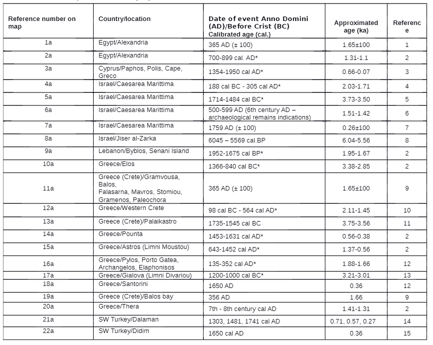 Table S1
Compilation of previously dated tsunami deposits occurring along the eastern Mediterranean coast. The location of these events and deposits is annotated in Figure 1. Ages with * are ones that are presented for (2σ).
Shtienberg et al (2020)
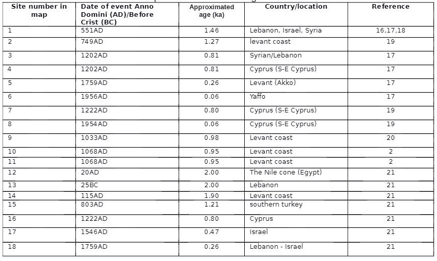 Table S2
Compilation of previously dated tsunami events occurring in the eastern Mediterranean. The location of these events and deposits is annotated in figure 1.
Shtienberg et al (2020)