Faulting Event I in Trench 1

Faulting Event I is the oldest
Holocene
palaeoseismic event identified in Trench TR-1,
which was excavated across the southern segment
of the
Bet She'an Fault
north of the archaeological site of
Tel Rehov.
In this area, the fault zone is expressed as a
40–50 m-high fault-scarp
slope separating the
tufa
plateau in the west from a lower surface capped
by soil in the east. The fault exposed in the
trench forms part of the
western marginal fault
zone of the
Dead Sea
Transform.
Geophysical surveys indicate that the trench
fault is one branch of a broader fault belt that
splits westward from the main marginal fault of
the Jordan Valley. The trench exposed a
fault-generated scarp developed within Late
Pleistocene
tufa deposits and subsequently buried
by younger
alluvial-colluvial
sediments sediments.
Faulting Event I is represented by a
colluvial wedge known as
Colluvial Unit 1 which accumulated against a newly formed
fault scarp on the
downthrown block following
earthquake rupture. The deposit consists of
angular tufa fragments together with weathered
oncolites,
charcoal, pottery fragments, landsnails and
reworked soil. Fragment size decreases away from
the scarp, consistent with deposition derived
from erosion of the
uplifted fault block. An
incipient soil horizon developed at the top of
the unit before deposition of the next colluvial
package, indicating a short interval of surface
stability between faulting events.
Zilberman et al (2004)
interpreted the deposit as a
colluvial wedge formed in response to earthquake-generated scarp
formation and subsequent hillslope erosion.
The event records predominantly
normal dip-slip
faulting
along the western marginal fault zone of the
Dead Sea Transform. Although the regional plate
boundary is dominated by left-lateral
strike-slip motion, the trench exposure records
localized
extensional deformation expressed as
vertical displacement and scarp formation. The
fault exposed in the trench represents only one
branch of a much wider fault belt that was
responsible for development of the western
Jordan Valley escarpment and associated block
tilting in the Bet She'an region.
The minimum vertical displacement associated with
Faulting Event I is approximately 1.2 m, based
on the preserved height of the colluvial wedge
deposited against the newly formed scarp. The
actual displacement may have been greater because
erosion modified the original scarp geometry and
the trench exposed only one strand of the broader
fault system.
Using the empirical normal fault displacement-magnitude
relationships of
Wells and
Coppersmith (1994), one can estimate that a vertical
displacement of this magnitude corresponds to an
earthquake of approximately
MW
6.7–6.8. Event I therefore represents a major
surface-rupturing earthquake capable of producing
significant regional damage.
Faulting Event I was dated using radiocarbon ages
obtained from
charcoal fragments incorporated
within Colluvial Unit 1. Four samples yielded
uncalibrated
radiocarbon ages of
2963 ± 96
BP (1013 ± 96 BCE), 2856 ± 48 BP (906 ± 48 BCE),
2843 ± 66 BP (893 ± 66 BCE), and 2706 ± 49 BP (756 ± 49 BCE).
Rather than forming a
normal stratigraphic sequence, the ages display
inverse radiocarbon stratigraphy, with older ages
occurring above younger ages. Zilberman et al. (2004)
explained this inversion as the result of
progressive erosion of the
uplifted fault block following scarp formation.
In their model, younger sediments near the original
ground surface were eroded first and deposited at
the base of the colluvial wedge, whereas continued
erosion later exposed progressively older sediments
that were subsequently incorporated into higher
parts of the deposit. Because of this process, the
authors regarded the youngest radiocarbon
determination, 2706 ± 49 BP (756 ± 49 BCE), as
the most reliable indicator of the timing of the
earthquake and concluded that Faulting Event I
occurred during the 7th century BCE.
This interpretation is not without uncertainty. The
youngest
uncalibrated age, 2706 ± 49 BP, converts to
756 ± 49 BCE, placing its central value in the
8th century BCE rather than the 7th century BCE.
Moreover, this age falls within the
800-400 BCE Hallstatt Plateau, where fluctuations
in atmospheric radiocarbon concentrations reduce
the precision of calibrated radiocarbon ages.
Because the reported ages are uncalibrated,
Bayesian modeling was not applied, and no
wiggle-matching sequence was available, the true
age range of the event is likely broader than
implied by the preferred date alone. Although the
youngest determination (8th century BCE) remains a reasonable
estimate under the authors' erosion model and matches with
the date of the
~760 BCE Amos Quakes, the
radiocarbon inversions and calibration uncertainties
loosen the chronological constraint and suggest
that Faulting Event I may have occurred sometime
between approximately 1050 and 700 BCE.



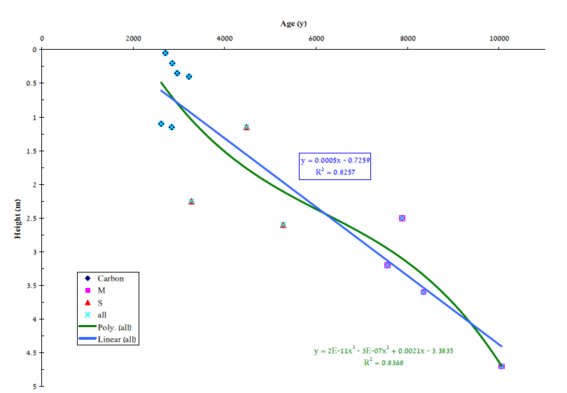
Figure 18
Figure 20