Faulting Event II in Trench 1

Faulting Event II is the second
Holocene
palaeoseismic event identified in Trench TR-1,
which was excavated across the
Bet She'an Fault
north of
Tel Rehov.
The trench crossed one strand of the
western marginal fault
zone
of the
Dead Sea
Transform.
The fault-generated scarp developed within Late
Pleistocene
tufa
deposits and was subsequently buried by younger
alluvial-colluvial
sediments.
Faulting Event II is represented by
Colluvial Unit 2, a second
colluvial wedge
that accumulated against a newly formed
fault scarp.
The unit consists of angular tufa fragments,
weathered
oncolites,
charcoal, pottery fragments,
freshwater gastropods
(Melanopsis), landsnails and
reworked soil. Zilberman et al. (2004)
interpreted the deposit as a second earthquake-
generated colluvial wedge formed after renewed
fault movement. The deposit also contains
material derived from erosion of older 7–8 ka
sediments exposed on the
uplifted fault block,
indicating continued post-seismic erosion and
reworking following scarp formation.
The event records predominantly
normal dip-slip
faulting
along the western margin of the Jordan Valley.
Although the regional plate boundary is
dominated by left-lateral strike-slip motion,
the trench records localized
extensional
deformation
expressed as vertical displacement and renewed
scarp growth. As with Faulting Event I, the
fault strand exposed in the trench represents
only one element of a broader fault belt
responsible for development of the western
Jordan Valley escarpment and associated block
tilting in the Bet She'an region.
The minimum vertical displacement associated
with Faulting Event II is approximately 1.5 m,
based on the preserved height of the scarp
against which Colluvial Unit 2 accumulated. The
actual displacement may have been greater
because erosion modified the original scarp
geometry and the trench exposed only one strand
of the broader fault system.
Using the empirical normal-fault
displacement-magnitude relationships of
Wells and
Coppersmith (1994), a displacement of this
size corresponds to an earthquake of
approximately
MW
6.7–6.9. Faulting Event II therefore represents
a major surface-rupturing earthquake capable of
producing severe shaking throughout the Bet
She'an and Jordan valleys.
Faulting Event II was dated using a combination of
charcoal,
land snails,
and
freshwater gastropods
(Melanopsis)
recovered from Colluvial Unit 2. Seven samples
yielded
uncalibrated
radiocarbon
ages.
Two charcoal samples yielded ages of 3222 ± 54
BP
(1272 ± 54 BCE) and 2614 ± 47 BP
(664 ± 47 BCE). Two land-snail samples yielded
ages of 4482 ± 51 BP (2532 ± 51 BCE) and
3277 ± 49 BP (1327 ± 49 BCE). Three
Melanopsis shell samples produced substantially
older ages of 7882 ± 53 BP (5932 ± 53 BCE),
7560 ± 52 BP (5610 ± 52 BCE), and
8350 ± 51 BP (6400 ± 51 BCE).
The oldest Melanopsis shell ages, which date to
the 6th and 7th millennia BCE, were interpreted
as outliers resulting from reworking of older
deposits and possibly enhanced by freshwater reservoir effects.
The remaining ages do not form a
normal stratigraphic sequence, but instead
display inverse radiocarbon stratigraphy, with
older ages occurring above younger ages.
Zilberman et al. (2004) explained this inversion in the
same manner as for Faulting Event I, attributing
it to progressive erosion of the
uplifted fault block following scarp
formation. In their model, younger sediments near
the original ground surface were eroded first and
deposited at the base of the colluvial wedge,
whereas continued erosion later exposed
progressively older sediments that were
subsequently incorporated into higher parts of
the deposit. Because of this process, the authors
regarded the youngest radiocarbon determination,
2614 ± 47 BP (664 ± 47 BCE), as the most
reliable indicator of the timing of the
earthquake and concluded that Faulting Event II
occurred during the 6th century BCE. They further
argued that only a relatively short interval
separated Faulting Events I and II. The limited
degree of soil development between the two
colluvial wedges supports this interpretation.
This interpretation is nevertheless subject to
considerable uncertainty. The youngest
uncalibrated age, 2614 ± 47 BP, converts to
664 ± 47 BCE, placing its central value in the
7th century BCE rather than the 6th century BCE.
In addition, this sample falls within the
800-400 BCE Hallstatt Plateau, where fluctuations
in atmospheric radiocarbon concentrations reduce
the precision of radiocarbon ages. Because no
Bayesian
modeling
or
wiggle-matching
sequence
was available, and because the dated materials
were clearly affected by reworking, the true age
of the earthquake is likely less tightly
constrained than the preferred date alone
suggests. Although a date near the 7th century
BCE remains a reasonable working estimate under the
authors' erosion model, the dating uncertainties suggest that
Faulting Event II may have occurred sometime
between approximately 900 and 500 BCE.



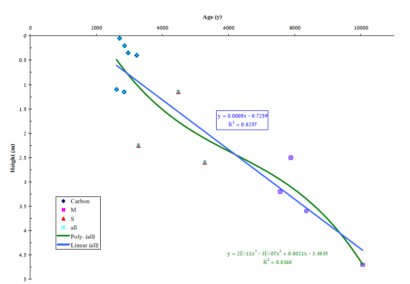
Figure 18
Figure 20