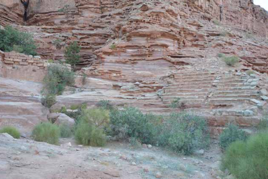
Petra - Wadi Sabra Theater
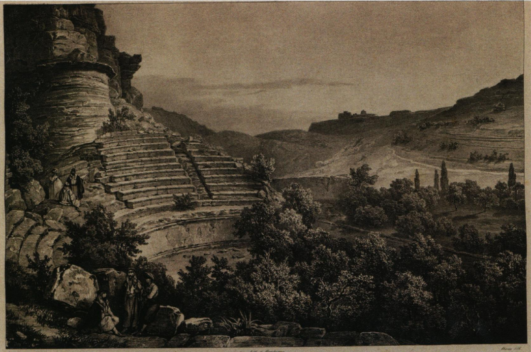
The theatre of Wâdî Sabrah in 1828, as published by L. de Laborde (1830: pl. 34)
Tholbecq et. al. (2016)
Right - Figure 49
View of the theater from the north:
- below, the orchestra overgrown with vegetation
- on the right, the stone bleachers preserved in situ
- on the left, the wall of the large cistern behind the theatre
- up, the cliff of the massif that borders Wadi Sabra and the natural fault from which the water comes in case of rain
Tholbecq et al (2019)
| Transliterated Name | Source | Name |
|---|---|---|
| Wadi Sabra | Arabic | وادي سابرا |
- Fig. 23 - Location Map
from Tholbecq et al (2018)
 Fig. 23
Satellite view of Petra with location of spa buildings.
Baths associated with a house in green
baths associated with a religious complex in red
(MAFP / Ifpo - Th. Fournet 2018, with a Google Basemap).
Tholbecq et al (2018) - Fig. 1 - Location Map
from Fournet & Tholbecq (2015)
 Fig. 1
Sabra site plan published by Léon de Laborde with locations of the sanctuary and baths
(LABORDE 1830, pl. 33)
Fournet & Tholbecq (2015)
- Wadi Sabra Theater in Google Earth
 Wadi Sabra Theater location in Google Earth
click on image to explore this site on a new tab in Google Earth
- Fig. 7 - General Plan from
Tholbecq et al (2019)
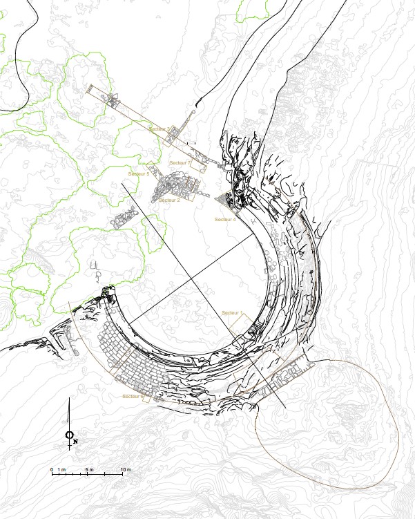 Fig. 7
General plan of the theater, based on a photogrammetric survey, with location of soundings (M. Kurdy).
Tholbecq et al (2019) - Fig. 14 - Plan of theater
from Tholbecq et. al. (2016)
 Fig. 14
Wadì Sabrah : a partial top plan of the theatre and associated remains, 2014
(G. Dumont, N. Paridaens, S. Delcros).
Tholbecq et. al. (2016) - Fig. 3 - Plan of theater
and the caravanserai/fortress from Tholbecq et al. (2022)
 Fig. 3
Plan of the theater and the caravanserai/fortress with the location of the sectors excavated in
- 2018 (in yellow)
- 2021 (in blue)
- 2022 (in red)
(recorded by N. Paridaens, L. Tholbecq, B. Van Nieuwenhove, P. Thiolas; background plan S. Delcros, W. Abu Azizeh, P. Rieth, L. Vallières; DAO N. Bloch, M. Kurdy & N. Paridaens).
Tholbecq et al. (2022)
- Fig. 7 - General Plan from
Tholbecq et al (2019)
Fig. 7
General plan of the theater, based on a photogrammetric survey, with location of soundings (M. Kurdy).
Tholbecq et al (2019) - Fig. 14 - Plan of theater
from Tholbecq et. al. (2016)
Fig. 14
Wadì Sabrah : a partial top plan of the theatre and associated remains, 2014
(G. Dumont, N. Paridaens, S. Delcros).
Tholbecq et. al. (2016) - Fig. 3 - Plan of theater
and the caravanserai/fortress from Tholbecq et al. (2022)
Fig. 3
Plan of the theater and the caravanserai/fortress with the location of the sectors excavated in
- 2018 (in yellow)
- 2021 (in blue)
- 2022 (in red)
(recorded by N. Paridaens, L. Tholbecq, B. Van Nieuwenhove, P. Thiolas; background plan S. Delcros, W. Abu Azizeh, P. Rieth, L. Vallières; DAO N. Bloch, M. Kurdy & N. Paridaens).
Tholbecq et al. (2022)
- Fig. 3 - Plan of theater
and the caravanserai/fortress from Tholbecq et al. (2022)
Fig. 3
Plan of the theater and the caravanserai/fortress with the location of the sectors excavated in
- 2018 (in yellow)
- 2021 (in blue)
- 2022 (in red)
(recorded by N. Paridaens, L. Tholbecq, B. Van Nieuwenhove, P. Thiolas; background plan S. Delcros, W. Abu Azizeh, P. Rieth, L. Vallières; DAO N. Bloch, M. Kurdy & N. Paridaens).
Tholbecq et al. (2022) - Fig. 6 - Plan of the
caravanserai/fortress from Tholbecq et al. (2022)
 Fig. 6
General plan of the caravanserai/fort with the location of the sectors excavated in 2021 and 2022
(surveys N. Paridaens, B. Van Nieuwenhove; DAO N. Paridaens).
Tholbecq et al. (2022) - Fig. 7 - Plan of the
SE part of the caravanserai/fortress from Tholbecq et al. (2022)
 Fig. 7
Map of the sectors excavated in 2021 and 2022 with the location of the principal (rooms ?, sectors ?)
(surveys and DAO N. Paridaens)
Tholbecq et al. (2022)
- Fig. 3 - Plan of theater
and the caravanserai/fortress from Tholbecq et al. (2022)
Fig. 3
Plan of the theater and the caravanserai/fortress with the location of the sectors excavated in
- 2018 (in yellow)
- 2021 (in blue)
- 2022 (in red)
(recorded by N. Paridaens, L. Tholbecq, B. Van Nieuwenhove, P. Thiolas; background plan S. Delcros, W. Abu Azizeh, P. Rieth, L. Vallières; DAO N. Bloch, M. Kurdy & N. Paridaens).
Tholbecq et al. (2022) - Fig. 6 - Plan of the
caravanserai/fortress from Tholbecq et al. (2022)
Fig. 6
General plan of the caravanserai/fort with the location of the sectors excavated in 2021 and 2022
(surveys N. Paridaens, B. Van Nieuwenhove; DAO N. Paridaens).
Tholbecq et al. (2022) - Fig. 7 - Plan of the
SE part of the caravanserai/fortress from Tholbecq et al. (2022)
Fig. 7
Map of the sectors excavated in 2021 and 2022 with the location of the principal (rooms ?, sectors ?)
(surveys and DAO N. Paridaens)
Tholbecq et al. (2022)
- Fig. 24 - Plan of Acropolis,
Sanctuary, and Baths in Wadi Sabra from Tholbecq (2016)
 Fig. 24
Plan of surveyed areas and archaeological remains within the site of Wadi Sabra.
Tholbecq (2016)
- Fig. 24 - Plan of Acropolis,
Sanctuary, and Baths in Wadi Sabra from Tholbecq (2016)
Fig. 24
Plan of surveyed areas and archaeological remains within the site of Wadi Sabra.
Tholbecq (2016)
- Fig. 13 - Drawing of Wadi Sabra
Theater from 1828 from Tholbecq et. al. (2016)
Fig. 13
The theatre of Wâdî Sabrah in 1828, as published by L. de Laborde (1830: pl. 34)
Tholbecq et. al. (2016)
| Effect | Location | Image(s) | Description/Comments |
|---|---|---|---|
| Recycled Building Elements suggests Collapsed Walls |
Blockade Walls (aka analemmata) ?
Fig. 7 General plan of the theater, based on a photogrammetric survey, with location of soundings (M. Kurdy). Tholbecq et al (2019) |
the upper parts of the walls seem to have been destroyed, then rebuilt by recycling collapsed bleacher seats- Tholbecq et al (2019) |
| Effect | Location | Image(s) | Description/Comments |
|---|---|---|---|
| Displaced Masonry Blocks ? | Northern masonry of the orchestra - Soundings 2 and 7
Fig. 7 General plan of the theater, based on a photogrammetric survey, with location of soundings (M. Kurdy). Tholbecq et al (2019) |
destruction of the northern masonry of the orchestra- Tholbecq et al (2019) |
- Earthquake Archeological Effects chart
of Rodríguez-Pascua et al (2013: 221-224)
 Earthquake Archeological Effects (EAE)
Rodríguez-Pascua et al (2013: 221-224)
| Effect | Location | Image(s) | Description/Comments | Intensity |
|---|---|---|---|---|
| Recycled Building Elements suggests Collapsed Walls |
Blockade Walls (aka analemmata) ?
Fig. 7 General plan of the theater, based on a photogrammetric survey, with location of soundings (M. Kurdy). Tholbecq et al (2019) |
the upper parts of the walls seem to have been destroyed, then rebuilt by recycling collapsed bleacher seats- Tholbecq et al (2019) |
VIII+ |
- Earthquake Archeological Effects chart
of Rodríguez-Pascua et al (2013: 221-224)
Earthquake Archeological Effects (EAE)
Rodríguez-Pascua et al (2013: 221-224)
| Effect | Location | Image(s) | Description/Comments | Intensity |
|---|---|---|---|---|
| Displaced Masonry Blocks ? | Northern masonry of the orchestra - Soundings 2 and 7
Fig. 7 General plan of the theater, based on a photogrammetric survey, with location of soundings (M. Kurdy). Tholbecq et al (2019) |
destruction of the northern masonry of the orchestra- Tholbecq et al (2019) |
VIII+ |