Tall al-'Umaryi
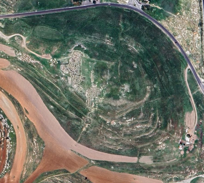
 Aerial shot of fortress at Tall al-'Umayri
Click on image to open a high res magnifiable image in a new tab
Credit: Aerial Photographic Archive for Archaeology in the Middle East
Photographer: Robert Howard Bewley
Reference: APAAME_20160928_RHB-0058.jpg
Copyright: Creative Commons Attribution-Noncommerical-No Derivative Works
| Transliterated Name | Source | Name |
|---|---|---|
| Tall al-'Umaryi | Arabic | |
| Tel El 'Umeiri | Arabic | |
| Tel Al Umaryi | Arabic | |
| Tell Al Umayri | Arabic | |
| el-'Ameireh | Arabic |
- Figure 1 - Location Map
from Geraty et al. (1986)
 Figure 1
Central Jordan. Tell el-'Umeiri is located on the northern edge of the Madaba Plains in the foothills surrounding Amman.
Geraty et al. (1986)
- Tell el-'Umeiri in Google Earth
 Tell el-'Umeiri
click on image to explore this site on a new tab in Google Earth
- Topographic Map with
excavation areas from Herr et al. (2009)
 Topographic Map of Tall al-'Umayri with the fields of excavation as of the 2008 season.
Herr et al. (2009) - Figure 2.1 - Topographic
Map with excavation areas from Herr et al. (2014)
 Fig. 2.1
Topographic map of Tall al-‘Umayri and the cumulative fields of excavation including the 1984 to 1998 seasons.
Herr et al. (2014) - Figure 6 - Topographic Map
with excavation areas from Geraty et al. (1986)
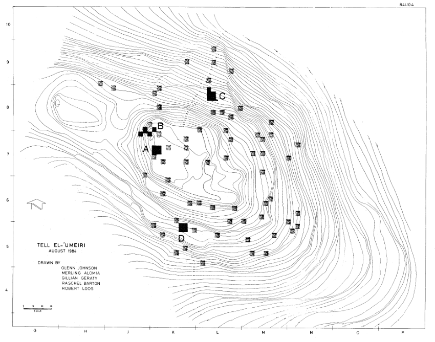 Figure 1
Central Jordan. Tell el-'Umeiri is located on the northern edge of the Madaba Plains in the foothills surrounding Amman.
Geraty et al. (1986)
- Topographic Map with
excavation areas from Herr et al. (2009)
Topographic Map of Tall al-'Umayri with the fields of excavation as of the 2008 season.
Herr et al. (2009) - Figure 2.1 - Topographic
Map with excavation areas from Herr et al. (2014)
Fig. 2.1
Topographic map of Tall al-‘Umayri and the cumulative fields of excavation including the 1984 to 1998 seasons.
Herr et al. (2014) - Figure 6 - Topographic Map
with excavation areas from Geraty et al. (1986)
Figure 1
Central Jordan. Tell el-'Umeiri is located on the northern edge of the Madaba Plains in the foothills surrounding Amman.
Geraty et al. (1986)
- Fig. 4.1c Plan of
Building C from Bramlett (2008)
 Fig. 4.1c
Plan of Building C
click on image to open in a new tab
Bramlett (2008)
- Fig. 4.1c Plan of
Building C from Bramlett (2008)
Fig. 4.1c
Plan of Building C
click on image to open in a new tab
Bramlett (2008)
- Fig. 16.3 Plan of
FP-6 walls from Clark (1989)
 Fig. 16.3
Plan of FP-6 walls
Clark (1989) - Figure 4.1 - Plan of
Square layout for Field B from Herr et al. (2014)
 Fig. 4.1
Field B: Square Layout, 1984-1998
Herr et al. (2014)
- Fig. 16.3 Plan of
FP-6 walls from Clark (1989)
Fig. 16.3
Plan of FP-6 walls
Clark (1989) - Figure 4.1 - Plan of
Square layout for Field B from Herr et al. (2014)
Fig. 4.1
Field B: Square Layout, 1984-1998
Herr et al. (2014)
- Fig. 16.3 Fields A (Phase 13),
B (Phase 11), and H (Phase 9) from Herr et al. (1999)
 Fig. 5
Tall al-`Umayri, Fields A (Phase 13), B (Phase 11), and H (Phase 9): Plan of the early Iron I perimeter wall as we re-construct its plan at the western edge of the site.
Herr et al. (1999) - Figure 2.2 - Plan of
Square layout for Fields A, B, and H from Herr et al. (2014)
 Fig. 2.2
Plan of Square layout for Fields A, B, and H.
Herr et al. (2014)
- Fig. 16.3 Fields A
(Phase 13), B (Phase 11), and H (Phase 9) from Herr et al. (1999
Fig. 5
Tall al-`Umayri, Fields A (Phase 13), B (Phase 11), and H (Phase 9): Plan of the early Iron I perimeter wall as we re-construct its plan at the western edge of the site.
Herr et al. (1999) - Figure 2.2 - Plan of
Square layout for Fields A, B, and H from Herr et al. (2014)
Fig. 2.2
Plan of Square layout for Fields A, B, and H.
Herr et al. (2014)
- Isometric drawing of
the Late Bronze building from Herr and Clark (2009)
 This computerized isometric drawing shows the layout of the Late Bronze building,
which includes two southern rooms (1 and 2), an entry hall (4), a large central room (3), and a back room (5)
along the western side of the building. A small photo of the cultic shrine is set in its niche in room 3.
This computerized isometric drawing shows the layout of the Late Bronze building,
which includes two southern rooms (1 and 2), an entry hall (4), a large central room (3), and a back room (5)
along the western side of the building. A small photo of the cultic shrine is set in its niche in room 3.
Illustration courtesy of Kent Bramlett
Herr and Clark (2009) - Artist's cut-away
reconstruction of the Late Bronze building from Herr and Clark (2009)
 Artist's cut-away reconstruction of the Late Bronze Age building.
One entered the building from the east through a stepped threshold lined with orthostats.
Visitors could either ascend the stone stairs to the second story or take one of two short
sets of stairs leading down into Room 4.
Artist's cut-away reconstruction of the Late Bronze Age building.
One entered the building from the east through a stepped threshold lined with orthostats.
Visitors could either ascend the stone stairs to the second story or take one of two short
sets of stairs leading down into Room 4.
Rhonda Root, artist
Herr and Clark (2009)
- Isometric drawing of
the Late Bronze building from Herr and Clark (2009)
This computerized isometric drawing shows the layout of the Late Bronze building,
which includes two southern rooms (1 and 2), an entry hall (4), a large central room (3), and a back room (5)
along the western side of the building. A small photo of the cultic shrine is set in its niche in room 3.
Illustration courtesy of Kent Bramlett
Herr and Clark (2009) - Artist's cut-away
reconstruction of the Late Bronze building from Herr and Clark (2009)
Artist's cut-away reconstruction of the Late Bronze Age building.
One entered the building from the east through a stepped threshold lined with orthostats.
Visitors could either ascend the stone stairs to the second story or take one of two short
sets of stairs leading down into Room 4.
Rhonda Root, artist
Herr and Clark (2009)
- Monumental Building with
earthquake damage from Herr et al. (2009)
 This monumental building, viewed from the east, may have been a temple. At the bottom
of the photo is a monumental entrance with a series of stairs leading down to the entrance room and another
series leading up to what must have been the second floor. Everything shows signs of
having been destroyed by an earthquake. Some of the surviving walls of the structure are almost 3 meters (10 feet) high.
This monumental building, viewed from the east, may have been a temple. At the bottom
of the photo is a monumental entrance with a series of stairs leading down to the entrance room and another
series leading up to what must have been the second floor. Everything shows signs of
having been destroyed by an earthquake. Some of the surviving walls of the structure are almost 3 meters (10 feet) high.
Herr et al. (2009) - Wall fragments of the
MB IIC period from Herr et al. (2009)
 Wall fragments of the MB IIC period are visible at the bottom of this photo. The very large boulders
almost qualify as "Cyclopean" masonry, a typical feature of Middle Bronze Age architecture. A lime-coated surface runs up to the wall stones.
Wall fragments of the MB IIC period are visible at the bottom of this photo. The very large boulders
almost qualify as "Cyclopean" masonry, a typical feature of Middle Bronze Age architecture. A lime-coated surface runs up to the wall stones.
Herr et al. (2009) - Fig. 16.4 Area B Field Phase 6
Beaten earth rampart with stabilizing wall from Clark (1989)
 Fig. 16.4
Beaten earth rampart with stabilizing wall
JW:Area B Field Phase 6
Clark (1989) - Fig. 4.6 Entry an Stairs of
Building C from Bramlett (2008)
 Fig. 4.6
Entry an Stairs of Building C
click on image to open in a new tab
Bramlett (2008)
- Monumental Building with
earthquake damage from Herr et al. (2009)
This monumental building, viewed from the east, may have been a temple. At the bottom
of the photo is a monumental entrance with a series of stairs leading down to the entrance room and another
series leading up to what must have been the second floor. Everything shows signs of
having been destroyed by an earthquake. Some of the surviving walls of the structure are almost 3 meters (10 feet) high.
Herr et al. (2009) - Wall fragments of the
MB IIC period from Herr et al. (2009)
Wall fragments of the MB IIC period are visible at the bottom of this photo. The very large boulders
almost qualify as "Cyclopean" masonry, a typical feature of Middle Bronze Age architecture. A lime-coated surface runs up to the wall stones.
Herr et al. (2009) - Fig. 16.4 Area B Field Phase 6
Beaten earth rampart with stabilizing wall from Clark (1989)
Fig. 16.4
Beaten earth rampart with stabilizing wall
JW:Area B Field Phase 6
Clark (1989) - Fig. 4.6 Entry an Stairs of
Building C from Bramlett (2008)
Fig. 4.6
Entry an Stairs of Building C
click on image to open in a new tab
Bramlett (2008)


 Fig. 2.3
Cumulative Integrated Phasing (IP) Chart.
Herr et al. (2014)
This chart is an attempt to establish a site-wide stratification. However, none of the connections are certain between the fields, except some of those between Fields A and B, and A and H which are adjacent to one another. We have tried to avoid phase proliferation by suggesting connections if there is no evidence to support them. A question mark beside a phase number indicates that the attribution is correct for the sequence and chronological period, but we are very uncertain to which integrated phase it should be applied. Usually, the least certainty occurs in those fields outside the acropolis, such as Fields C, E, and F. The abbreviation “shds” stands for “sherds;” “Tr” stands for the trench excavated in Field G (Fisher 1997a).
Information for some of the EB attributions has come from T. Harrison who is working on the final publication of the EB material. The assignment of FP 10 in Field C, carvings in bedrock, to IP 24 is far from certain. It is simply earlier than the other EB 3 phases in Field C.
IPs 24-21 were determined by the architecturally differentiated EB 3 phases in Field D. Pottery assemblages were generally not specific enough to help separate the earth layers with confidence. The phasing in Field C is clear, but its equation with the phases of Field D is speculative, based on the room in Square 8L63 (Field C, FP 8), which was similar to those in Field D, FP 5. The same is true of the Field G remains: because bedrock was not reached there and because smashed pots were found, we simply equated the top two EB 3 phases with the two most significant upper occupational phases in Field D, which also had smashed vessels.
The two MB 2C phases (IPs 18-17) were clearly separated in Field C. Although we have found only one MB 2C phase in Field B, the pottery in the rampart infers two original phases. While the rampart dated to MB 2C, the pottery within the rampart was also MB 2C, indicating an earlier settlement for the origin of the pottery. We have thus equated the construction of the Field B rampart with the later MB phase in Field C. The MB evidence from Fields F and G could be from either phase.
The strongest evidence for IP 16 (LB 2, based on the pottery) was found in a major new building in Field B (FP 13) with minor deposits in Fields A and F where we encountered extra-urban earth layers.
The interrelationships of the early stages of the Iron 1 period, IPs 15 to 13, are very good for Fields A and B, both of which have three distinct phases of occupation; the second one was massively destroyed. In Field F, only one phase was inside the city, while the separation into two phases is connected with an apparent extra-urban terrace wall. The remains from Field E have simply been attributed to both IPs 14 and 13 because of their general ceramic date.
As for IPs 12to 11, the storeroom in Field B and the walls in Field A were clearly above the remains of IPs 13 and 14. But because these are the only in-situ architectural deposits from the late Iron 1 and/or early Iron 2 periods so far discovered on the mound, we feel relatively certain the remains from Field E (FP 7) at least overlapped them.
The determination of late Iron 2/Persian IPs 10-6 is based on the stratification of Fields A and B, although stratigraphic connections between the fields are not always direct even within Field A (thus we have had to use a subset of phase numbers with “N” for “north” for some deposits). However, both Fields A and B have the same number of phases with similar relationships to earlier and later phases. The earliest phase in both fields is made up of pits (Field B) and small, weak installations (Field A), suggesting a poor settlement of newcomers. The last phase was that into which the Early Roman ritual bath was dug in both fields. However, it is possible that the intervening phases could have been isolated reconstructions limited to individual structures. The phasing of Field H equates with the main phases of Field A. Although also containing the same number of phases as Fields A and B except for one, the upper phases in Field F seem to be extra-urban in nature and probably had a separate history. The attribution of phases in Field C is guesswork, based on their general ceramic date and sequence. All the late Iron 2/Persian materials from Field E, discerned only in three phases, have been connected with tell phases with great uncertain ty; presumably, the water source would have been used throughout.
The early Roman ritual bath straddling Fields A and B makes a clear connection for IP 4. Later phases have been connected based on general ceramic date.
 Loci excavated in 1996 and 1998
Herr et al. (2014)
The early Iron 1 phases (11B and 11A in 1994) have appeared in all squares in the Field and have demanded most of our attention in Field B since excavations began in 1984. It represents one of the very earliest and best-preserved defense systems anywhere in the Levant from this time. From previous seasons we know the basic features of the defenses (Clark 2002: fig. 4.4): a dry moat at the base of the western slope (reusing the old MB 2C moat), a retaining wall on the east side of the moat (toward the tell), a steep rampart (35°, although this leveled somewhat as it approached the perimeter wall), a stabilizing row of stones to help hold the top rampart layer in place against erosion, and a perimeter wall. This was all built atop the disturbed and partially eroded Phase 14 Middle Bronze rampart following a major earthquake, dated to around 1200 (Clark 2002: 49-51).
Inside the perimeter wall in earlier seasons we discovered parts of two buildings built against the wall (fig. 4.22 below). Building A was divided into three rooms, including a cultic installation and domestic food-preparation area. The perimeter wall and adjoining rooms were covered, and thus preserved, by up to 2 m of destruction debris from the ceiling/roof of two stories, the lower constructed of stone and the upper of mudbrick. Building B began to emerge in 1994 and, although excavations to that point did not expose all the features of the building, the shape of a large, multi-room building was becoming apparent. At the time we designated four rooms, beginning at the eastern end. The functions of Rooms B1, B2, and B3 were not readily clear to us following the 1994 season, but Room B4 at the back of the building and situated against the perimeter wall revealed approximately 70 collared pithoi, half of which had fallen down from a second-story store room along with ballistica, lance points, and the scattered burned bones of at least four people, likely killed on the roof attempting to defend the settlement from attackers, if the weapons have any relevance, or perhaps simply occupying the house on the second story when killed.
Based on the presence of early Iron 1 ceramic material (including a few sherds from the tail end of the LB tradition) in the Phase 11 rampart layers, we inferred a second, earlier phase following the 1992 season (Clark 2000: 66-73). Phase 11 was thus divided into two parts: Phase 11B represented a transitional Late Bronze/early Iron 1 settlement prior to the construction of the defenses. It was the debris from this occupation that provided the rampart builders with their construction material. The only definitive Phase 11B remains we have been able to identify with certainty are those now reused in the rampart construction. However, we have been looking to continued excavation that could contribute to an understanding of Phase 11B structures inside the perimeter wall. A number of rooms now accessible to us reveal two levels of stone paving, normally larger flagstones immediately over cobbles, in Squares 7K80, 7K81, and 7K90. Were these repairs to damaged floors? If so, this damage was perhaps connect ed with the earthquake that appears to have broken the bedrock beneath the Middle Bronze rampart in Square 7J87 forcing the reconstruction of the defensive system (Clark 2000: 66-73; 2002: 51). Interpretive challenges remain, however, about how the house related to the perimeter wall, because the wall was constructed post earthquake and the house appears to have abutted the wall.
Following the 1996/98 excavations, we feel it is time to give this phase independent status and have thus designated it Phase 12. The natural disaster in the form of the earthquake around 1200 B.C. has drawn a substantial stratigraphic line between what preceded it and what followed that we feel justified in renaming the phase. As already noted (Clark 2000: 66-73), the evidence outside the perimeter wall is convincing. And, while not as persuasive, the repairs inside the settlement and now new stratigraphy from Square 7K92 at least provide some support for the idea.
Excavations carried out in 1996/98 in Square 7K92 have forced us to consider several matters related to the transition between the Late Bronze (Phase 13) evidence we now have and the early Iron 1 remains (Phase 11), especially the four-room or pillared house (Building B) immediately west of this square. In particular, two areas of excavation deserve mention: first, a massive pit 1.5 m east of the Phase 11 four-room house (Building B), and second, limited stratigraphy in the space between house and pit.
The pit itself was fortuitously dug in antiquity into a series of pre-existing, superimposed walls that provided well for the lining of the pit on east, south, and west sides (fig. 4.19). At the bottom of the pit, Phase 14 Walls 7K92:24 and 29 and hard-packed Surfaces 35 and 36 marked the bottom of the pit.
Our description will begin on the eastern side of the pit and move clockwise (fig. 4.18). Directly above and virtually following the same line as Phase 14 Wall 24 (6 degrees difference in orientation), Wall 7K92:22 added another 1.4 m of height to the eastern wall of the pit. Like Wall 24 (and Wall 2 above it), Wall 22 was half buried in the east balk of the square, in fact disappears into it toward the northern end of the east balk. It also abuts Phase 14 Wall 20 at its southern extremity, a wall that survives to a height within 0.75 m of Wall 22. Stones in Wall 22 were mostly small boulders, with some cobbles and a few medium boulders. Atop Wall 22, Phase 6 Wall 7K92:2 was founded, again along the same orientation.
Also abutting Phase 14 Wall 20, now in the south western corner of the pit, was Wall 7K92:25. It consisted of irregularly laid small and medium boulders maintaining the same orientation as Phase 14 Wall 29, although now slightly curvilinear (352° to 010°) and resting directly on top of it for the most part. It ranged from 0.8 to 1.1 m in height and may actually have provided founding for Foundation Wall 7K92:23 precisely over it. Wall 23, most ly small and some medium boulders, was also slightly curvilinear (orientations changed from 344° to 010°), and survived beneath Wall 7K92:9 to a height of 0.5 to 0.7 m. Wall 9, not curvilinear and oriented at 020°, rested direct ly atop Wall 23, except along the southern portion where Wall 23 begins its curve to the east. In construction, it consisted of an even split between small and medium boulders, was 0.90 to 0.95 m wide, and measured 0.57 to 0.65 m high. It represents the latest of the superimposed walls to be used as the western lining for the fill in the pit.
In the pit itself, beginning on top of the Phase 14 Layers 31 and 32 and building upward, were Layers 7K92:30, 26 and 14/19. Layer 30 covered the entire space within the pit for an average depth of 0.35 m (its top level being determined arbitrarily at the beginning of a new sea son of excavation) and consisted of brown earth, contain ing large amounts of bones, some ash pockets and pebbles, and several small object fragments (mostly undeterminable), including a stone plate fragment (Object No. B986561). Layer 7K92:26 represented the earth above Layer 30. It was yellowish-brown, 0.7 m deep, and contained a large ash pocket, large amounts of bones and some shells. It was also arbitrarily set apart from what lay above it: Layers 7K92:14/19. Layers 14 and 19 consisted of brown earth between 1.05 and 1.32 m deep. Layer 19 marked a 1-to-1.5-m-wide portion of pit debris beneath and north of Phase 7(?) Wall 7K92:12, while Layer 14 filled the remainder of the pit at the same level and should be understood to represent the same earth layer. This layer contained ash and nari pockets, some bricky materials, a remarkable amount of bones, pottery, and small objects/object fragments. By far, most of the objects/ object fragments were domestic (textile operations, food preparation and storage, cosmetic application, recreation), and a very small number administrative or military. All the earth loci in the pit consisted of thin layers with ashy deposits and were slightly sloped from the west down toward the east. They thus represented periodic fill debris from above.
In the end, the superimposed walls (24 and 22 on the east; 20 on the south; and 29, 25, 23 and 9 on the west) formed the contours of the massive pit (Locus 7K92:46) measuring 2.7 m wide, 4.2 m long and 2.4 m deep and containing pottery dating for the most part to the earliest years of the Iron 1 period. The contents of the pit included 50 small objects/object fragments, 4700 ceramic sherds and approximately 15,000 bone fragments.
Some stratigraphic questions remain, but the picture is fairly clear overall. It appears the inhabitants of ‘Umayri at around 1200 or slightly before dug out a garbage pit. They excavated down to the hard-packed earth of Phase 14 Surfaces 35 and 36 within an area bounded by Walls 24 on the east, 20 on the south and 29 on the west. On the one hand, did they construct the superimposed Walls 22 on the east (above 24) and 25 and 23 on the west (above 29) to increase the depth of the pit or to keep it from collapsing? Both Walls 22 and 23 were founded at the same level. But, at least on the western side of the pit, Wall 9 raised this side further, now to a level equal with the top surviving level of Wall 22. On the other hand, were the Phase 12 inhabitants simply fortunate to have found already superimposed walls in place (Walls 24 and 22 on the east and Walls 29, 25, 23 and 9 on the west) and oriented nicely for their purposes? Further excavation of these walls will be necessary to provide answers to these questions.
When completed, the pit was filled over time with refuse that formed a homogenous fill for virtually its entire depth. Since there were so many sherds, because most of the objects/object fragments were domestic in nature and since the bones were almost wholly those of edible portions of domesticated animals (Peters, Pöllath, and vonden Driesch 2002), we suggest this was a disposal site per haps for the household immediately west (and upwind) of the pit, along with other households. There was also a very large ratio of cooking potsherds among the ceramic remains, again suggesting that the fill contained refuse from cooking and eating.
Given the difficulty of placing the pit stratigraphically before the earthquake of 1200 or after, in light of the problems associated with our understanding of the Iron 1 four-room house (Building B) to the west of the pit in terms of its initial construction and repairs (did construction or repairs or both come after the earthquake?), and given the lack of a direct stratigraphic connection between the two features, we can only place the pit in Phase 12 with some reservations. These reservations extend to uncertain ties about assigning the four-room house to Phase 11, a phase representing construction inside the perimeter wall following the earthquake, although a Phase 11 designation appears the more likely for Building B.
This brings us to the area west of the pit but east of the four-room house in Square 7K92. Several earth layers became apparent in the western portion of the square, lay ers that have not yielded as much stratigraphic information as we could wish. On top of Phase 14 Surfaces 40, 38 and 39 was Layer 7K92:37 in the southwestern corner of the square. It measured 2.06 by 1.27 m and was 0.5 m deep. Its top level was arbitrarily determined. Farther north along the west balk were Surfaces 7K92:27 and 28. Surface 27 was preserved to a length of 0.85 m and a width of 0.65 and consisted of a very pale brown, plaster-like material. Likely associated with this surface, Surface 28 was made up of three flat-lying stones (two medium boulders and one small boulder) that might have been part of a pavement (or the top courses of a wall?). Over all these loci there was another earth layer (7K92:18), which contained brown earth and large amounts of pebbles and cobbles. It stretched over most of the western third of the square and measured 0.45 m deep.
Unfortunately, given the limited area within which to excavate and the complex potential connections with other walls(?), very little can be said about these loci at the present time. Ceramic evidence fairly consistently points to an early Iron 1 date (fig. 4.20), but later pitting in the area has increased the risk of contamination.
Fig. 2.3Cumulative Integrated Phasing (IP) Chart.
Herr et al. (2014)
This chart is an attempt to establish a site-wide stratification. However, none of the connections are certain between the fields, except some of those between Fields A and B, and A and H which are adjacent to one another. We have tried to avoid phase proliferation by suggesting connections if there is no evidence to support them. A question mark beside a phase number indicates that the attribution is correct for the sequence and chronological period, but we are very uncertain to which integrated phase it should be applied. Usually, the least certainty occurs in those fields outside the acropolis, such as Fields C, E, and F. The abbreviation “shds” stands for “sherds;” “Tr” stands for the trench excavated in Field G (Fisher 1997a).
Information for some of the EB attributions has come from T. Harrison who is working on the final publication of the EB material. The assignment of FP 10 in Field C, carvings in bedrock, to IP 24 is far from certain. It is simply earlier than the other EB 3 phases in Field C.
IPs 24-21 were determined by the architecturally differentiated EB 3 phases in Field D. Pottery assemblages were generally not specific enough to help separate the earth layers with confidence. The phasing in Field C is clear, but its equation with the phases of Field D is speculative, based on the room in Square 8L63 (Field C, FP 8), which was similar to those in Field D, FP 5. The same is true of the Field G remains: because bedrock was not reached there and because smashed pots were found, we simply equated the top two EB 3 phases with the two most significant upper occupational phases in Field D, which also had smashed vessels.
The two MB 2C phases (IPs 18-17) were clearly separated in Field C. Although we have found only one MB 2C phase in Field B, the pottery in the rampart infers two original phases. While the rampart dated to MB 2C, the pottery within the rampart was also MB 2C, indicating an earlier settlement for the origin of the pottery. We have thus equated the construction of the Field B rampart with the later MB phase in Field C. The MB evidence from Fields F and G could be from either phase.
The strongest evidence for IP 16 (LB 2, based on the pottery) was found in a major new building in Field B (FP 13) with minor deposits in Fields A and F where we encountered extra-urban earth layers.
The interrelationships of the early stages of the Iron 1 period, IPs 15 to 13, are very good for Fields A and B, both of which have three distinct phases of occupation; the second one was massively destroyed. In Field F, only one phase was inside the city, while the separation into two phases is connected with an apparent extra-urban terrace wall. The remains from Field E have simply been attributed to both IPs 14 and 13 because of their general ceramic date.
As for IPs 12to 11, the storeroom in Field B and the walls in Field A were clearly above the remains of IPs 13 and 14. But because these are the only in-situ architectural deposits from the late Iron 1 and/or early Iron 2 periods so far discovered on the mound, we feel relatively certain the remains from Field E (FP 7) at least overlapped them.
The determination of late Iron 2/Persian IPs 10-6 is based on the stratification of Fields A and B, although stratigraphic connections between the fields are not always direct even within Field A (thus we have had to use a subset of phase numbers with “N” for “north” for some deposits). However, both Fields A and B have the same number of phases with similar relationships to earlier and later phases. The earliest phase in both fields is made up of pits (Field B) and small, weak installations (Field A), suggesting a poor settlement of newcomers. The last phase was that into which the Early Roman ritual bath was dug in both fields. However, it is possible that the intervening phases could have been isolated reconstructions limited to individual structures. The phasing of Field H equates with the main phases of Field A. Although also containing the same number of phases as Fields A and B except for one, the upper phases in Field F seem to be extra-urban in nature and probably had a separate history. The attribution of phases in Field C is guesswork, based on their general ceramic date and sequence. All the late Iron 2/Persian materials from Field E, discerned only in three phases, have been connected with tell phases with great uncertain ty; presumably, the water source would have been used throughout.
The early Roman ritual bath straddling Fields A and B makes a clear connection for IP 4. Later phases have been connected based on general ceramic date.
Loci excavated in 1996 and 1998Herr et al. (2014)
The early Iron 1 phases (11B and 11A in 1994) have appeared in all squares in the Field and have demanded most of our attention in Field B since excavations began in 1984. It represents one of the very earliest and best-preserved defense systems anywhere in the Levant from this time. From previous seasons we know the basic features of the defenses (Clark 2002: fig. 4.4): a dry moat at the base of the western slope (reusing the old MB 2C moat), a retaining wall on the east side of the moat (toward the tell), a steep rampart (35°, although this leveled somewhat as it approached the perimeter wall), a stabilizing row of stones to help hold the top rampart layer in place against erosion, and a perimeter wall. This was all built atop the disturbed and partially eroded Phase 14 Middle Bronze rampart following a major earthquake, dated to around 1200 (Clark 2002: 49-51).
Inside the perimeter wall in earlier seasons we discovered parts of two buildings built against the wall (fig. 4.22 below). Building A was divided into three rooms, including a cultic installation and domestic food-preparation area. The perimeter wall and adjoining rooms were covered, and thus preserved, by up to 2 m of destruction debris from the ceiling/roof of two stories, the lower constructed of stone and the upper of mudbrick. Building B began to emerge in 1994 and, although excavations to that point did not expose all the features of the building, the shape of a large, multi-room building was becoming apparent. At the time we designated four rooms, beginning at the eastern end. The functions of Rooms B1, B2, and B3 were not readily clear to us following the 1994 season, but Room B4 at the back of the building and situated against the perimeter wall revealed approximately 70 collared pithoi, half of which had fallen down from a second-story store room along with ballistica, lance points, and the scattered burned bones of at least four people, likely killed on the roof attempting to defend the settlement from attackers, if the weapons have any relevance, or perhaps simply occupying the house on the second story when killed.
Based on the presence of early Iron 1 ceramic material (including a few sherds from the tail end of the LB tradition) in the Phase 11 rampart layers, we inferred a second, earlier phase following the 1992 season (Clark 2000: 66-73). Phase 11 was thus divided into two parts: Phase 11B represented a transitional Late Bronze/early Iron 1 settlement prior to the construction of the defenses. It was the debris from this occupation that provided the rampart builders with their construction material. The only definitive Phase 11B remains we have been able to identify with certainty are those now reused in the rampart construction. However, we have been looking to continued excavation that could contribute to an understanding of Phase 11B structures inside the perimeter wall. A number of rooms now accessible to us reveal two levels of stone paving, normally larger flagstones immediately over cobbles, in Squares 7K80, 7K81, and 7K90. Were these repairs to damaged floors? If so, this damage was perhaps connect ed with the earthquake that appears to have broken the bedrock beneath the Middle Bronze rampart in Square 7J87 forcing the reconstruction of the defensive system (Clark 2000: 66-73; 2002: 51). Interpretive challenges remain, however, about how the house related to the perimeter wall, because the wall was constructed post earthquake and the house appears to have abutted the wall.
Following the 1996/98 excavations, we feel it is time to give this phase independent status and have thus designated it Phase 12. The natural disaster in the form of the earthquake around 1200 B.C. has drawn a substantial stratigraphic line between what preceded it and what followed that we feel justified in renaming the phase. As already noted (Clark 2000: 66-73), the evidence outside the perimeter wall is convincing. And, while not as persuasive, the repairs inside the settlement and now new stratigraphy from Square 7K92 at least provide some support for the idea.
Excavations carried out in 1996/98 in Square 7K92 have forced us to consider several matters related to the transition between the Late Bronze (Phase 13) evidence we now have and the early Iron 1 remains (Phase 11), especially the four-room or pillared house (Building B) immediately west of this square. In particular, two areas of excavation deserve mention: first, a massive pit 1.5 m east of the Phase 11 four-room house (Building B), and second, limited stratigraphy in the space between house and pit.
The pit itself was fortuitously dug in antiquity into a series of pre-existing, superimposed walls that provided well for the lining of the pit on east, south, and west sides (fig. 4.19). At the bottom of the pit, Phase 14 Walls 7K92:24 and 29 and hard-packed Surfaces 35 and 36 marked the bottom of the pit.
Our description will begin on the eastern side of the pit and move clockwise (fig. 4.18). Directly above and virtually following the same line as Phase 14 Wall 24 (6 degrees difference in orientation), Wall 7K92:22 added another 1.4 m of height to the eastern wall of the pit. Like Wall 24 (and Wall 2 above it), Wall 22 was half buried in the east balk of the square, in fact disappears into it toward the northern end of the east balk. It also abuts Phase 14 Wall 20 at its southern extremity, a wall that survives to a height within 0.75 m of Wall 22. Stones in Wall 22 were mostly small boulders, with some cobbles and a few medium boulders. Atop Wall 22, Phase 6 Wall 7K92:2 was founded, again along the same orientation.
Also abutting Phase 14 Wall 20, now in the south western corner of the pit, was Wall 7K92:25. It consisted of irregularly laid small and medium boulders maintaining the same orientation as Phase 14 Wall 29, although now slightly curvilinear (352° to 010°) and resting directly on top of it for the most part. It ranged from 0.8 to 1.1 m in height and may actually have provided founding for Foundation Wall 7K92:23 precisely over it. Wall 23, most ly small and some medium boulders, was also slightly curvilinear (orientations changed from 344° to 010°), and survived beneath Wall 7K92:9 to a height of 0.5 to 0.7 m. Wall 9, not curvilinear and oriented at 020°, rested direct ly atop Wall 23, except along the southern portion where Wall 23 begins its curve to the east. In construction, it consisted of an even split between small and medium boulders, was 0.90 to 0.95 m wide, and measured 0.57 to 0.65 m high. It represents the latest of the superimposed walls to be used as the western lining for the fill in the pit.
In the pit itself, beginning on top of the Phase 14 Layers 31 and 32 and building upward, were Layers 7K92:30, 26 and 14/19. Layer 30 covered the entire space within the pit for an average depth of 0.35 m (its top level being determined arbitrarily at the beginning of a new sea son of excavation) and consisted of brown earth, contain ing large amounts of bones, some ash pockets and pebbles, and several small object fragments (mostly undeterminable), including a stone plate fragment (Object No. B986561). Layer 7K92:26 represented the earth above Layer 30. It was yellowish-brown, 0.7 m deep, and contained a large ash pocket, large amounts of bones and some shells. It was also arbitrarily set apart from what lay above it: Layers 7K92:14/19. Layers 14 and 19 consisted of brown earth between 1.05 and 1.32 m deep. Layer 19 marked a 1-to-1.5-m-wide portion of pit debris beneath and north of Phase 7(?) Wall 7K92:12, while Layer 14 filled the remainder of the pit at the same level and should be understood to represent the same earth layer. This layer contained ash and nari pockets, some bricky materials, a remarkable amount of bones, pottery, and small objects/object fragments. By far, most of the objects/ object fragments were domestic (textile operations, food preparation and storage, cosmetic application, recreation), and a very small number administrative or military. All the earth loci in the pit consisted of thin layers with ashy deposits and were slightly sloped from the west down toward the east. They thus represented periodic fill debris from above.
In the end, the superimposed walls (24 and 22 on the east; 20 on the south; and 29, 25, 23 and 9 on the west) formed the contours of the massive pit (Locus 7K92:46) measuring 2.7 m wide, 4.2 m long and 2.4 m deep and containing pottery dating for the most part to the earliest years of the Iron 1 period. The contents of the pit included 50 small objects/object fragments, 4700 ceramic sherds and approximately 15,000 bone fragments.
Some stratigraphic questions remain, but the picture is fairly clear overall. It appears the inhabitants of ‘Umayri at around 1200 or slightly before dug out a garbage pit. They excavated down to the hard-packed earth of Phase 14 Surfaces 35 and 36 within an area bounded by Walls 24 on the east, 20 on the south and 29 on the west. On the one hand, did they construct the superimposed Walls 22 on the east (above 24) and 25 and 23 on the west (above 29) to increase the depth of the pit or to keep it from collapsing? Both Walls 22 and 23 were founded at the same level. But, at least on the western side of the pit, Wall 9 raised this side further, now to a level equal with the top surviving level of Wall 22. On the other hand, were the Phase 12 inhabitants simply fortunate to have found already superimposed walls in place (Walls 24 and 22 on the east and Walls 29, 25, 23 and 9 on the west) and oriented nicely for their purposes? Further excavation of these walls will be necessary to provide answers to these questions.
When completed, the pit was filled over time with refuse that formed a homogenous fill for virtually its entire depth. Since there were so many sherds, because most of the objects/object fragments were domestic in nature and since the bones were almost wholly those of edible portions of domesticated animals (Peters, Pöllath, and vonden Driesch 2002), we suggest this was a disposal site per haps for the household immediately west (and upwind) of the pit, along with other households. There was also a very large ratio of cooking potsherds among the ceramic remains, again suggesting that the fill contained refuse from cooking and eating.
Given the difficulty of placing the pit stratigraphically before the earthquake of 1200 or after, in light of the problems associated with our understanding of the Iron 1 four-room house (Building B) to the west of the pit in terms of its initial construction and repairs (did construction or repairs or both come after the earthquake?), and given the lack of a direct stratigraphic connection between the two features, we can only place the pit in Phase 12 with some reservations. These reservations extend to uncertain ties about assigning the four-room house to Phase 11, a phase representing construction inside the perimeter wall following the earthquake, although a Phase 11 designation appears the more likely for Building B.
This brings us to the area west of the pit but east of the four-room house in Square 7K92. Several earth layers became apparent in the western portion of the square, lay ers that have not yielded as much stratigraphic information as we could wish. On top of Phase 14 Surfaces 40, 38 and 39 was Layer 7K92:37 in the southwestern corner of the square. It measured 2.06 by 1.27 m and was 0.5 m deep. Its top level was arbitrarily determined. Farther north along the west balk were Surfaces 7K92:27 and 28. Surface 27 was preserved to a length of 0.85 m and a width of 0.65 and consisted of a very pale brown, plaster-like material. Likely associated with this surface, Surface 28 was made up of three flat-lying stones (two medium boulders and one small boulder) that might have been part of a pavement (or the top courses of a wall?). Over all these loci there was another earth layer (7K92:18), which contained brown earth and large amounts of pebbles and cobbles. It stretched over most of the western third of the square and measured 0.45 m deep.
Unfortunately, given the limited area within which to excavate and the complex potential connections with other walls(?), very little can be said about these loci at the present time. Ceramic evidence fairly consistently points to an early Iron 1 date (fig. 4.20), but later pitting in the area has increased the risk of contamination.
- from Clark (1989:247-249)
- Fig. 16.3 Plan of
FP-6 walls from Clark (1989)
Fig. 16.3
Plan of FP-6 walls
Clark (1989)
- Fig. 16.3 Plan of
FP-6 walls from Clark (1989)
Fig. 16.3
Plan of FP-6 walls
Clark (1989)
 Clark (1989)
- Fig. 16.4 Area B
Field Phase 6 Beaten earth rampart with stabilizing wall from Clark (1989)
Fig. 16.4
Beaten earth rampart with stabilizing wall
JW:Area B Field Phase 6
Clark (1989)
Field Phase 6 contained the most extensive remains of any Field Phase yet excavated in Field D. After one season many of the stratigraphic connections were clear.
Laid against the apparent west face of the FP-7 mudbrick structure was Wall 7K90:10=7J89:11. It was constructed of small to medium-sized boulders with chink stones, was .7-1.0 m wide, and ran at a 200 orientation for a distance of ca. 7 m before breaking off at both ends. Future excavation may uncover lower courses extending further in both di rections. The stones at the northern end of the ex tant wall in 7K90 were poorly preserved, perhaps because of a fire that left this portion of the wall almost totally disintegrated to lime powder. Excavation has not proceeded deeply enough to determine the number of courses in the wall or the existence of associated surfaces or foundation trenches.
Wall 7K90:11, running to the east at 105°, in the north balk may have been laid into (or possibly against) the mudbricks of 5. However, the stones of this wall, large boulders extending only partially into the Square, made up what appeared to have been a much more substantial wall than Wall 10. The inter section of the two walls was outside the Square to the north, and precise relationships could not be determined from either the architecture or soil layer relationships.
Farther south, Wall 7J89:9 bonded with Wall 11 and ran to the west at 295°. Three to four courses of large cobbles and small boulders have so far been excavated. But because it angled out of the Square to the north as it ran west, it was not entirely measurable. It is assumed, however, that Wall 9 joined Wall 7J89:22 to the west.
When the east balk of 7J88 (immediately to the east of 7J89) was removed, the complete width of Wall 22 (=7J88:6) was exposed. The top two-three courses consisted of large cobbles and small boulders with chinkstones similar to the construction of Wall 9. Beneath these, however, the extant portion of the wall was constructed of four to five courses of mostly medium and a few large boulders. Its width as presently excavated was between 1.40 and 1.56 m, orientation was 25°, and it leaned westward at about 10° off plumb. Whether this leaning was due to upslope pressure, earthquake, or construction technique may be impossible to determine from field evidence. Its contemporary surface on the up hill side has not yet been uncovered, nor have its foundation courses been reached. The continuation of this wall was visible on the surface of the mound as it went around the northwest corner of the tell. The above walls suggest a casemate defensive structure: Outer Wall 7J89:22=7J88:6; Inner Wall 7K90:11=7J89:11; and Cross Wall 7J89:9.
Sealing against the outer casemate wall on its exterior side was a beaten nari-and-clay rampart, exposed in Square 7J88 (Locus 5) and excavated in 7J98 (Loci 4-9). Square 7J98:4, besides sloping up to the casemate wall from the west, arched upward to the north, crowned, then descended slightly (fig. 16.4).
A 2 x 5 m probe in Square 7J98 examined the construction of the rampart most likely to be the surface of an earlier beaten-earth rampart (see FP 7). Upon this lower rampart, and sloping at 32°, rested the foundations of the upper rampart (Locus 9), consisting of loosely-packed, sharply-angular limestone boulders (large to small in size). Evidently they were intended to prevent the new rampart from slipping on the smooth face of the lower rampart.
On the stones of Locus 9 was a composite layer of cobble-sized nari chunks and pockets of, brownish-yellow clay (Locus 8). It measured 1.1 to 1.2 m in thickness, providing a substantial and cohesive substructure. Locus 8 also sloped down to the west at 32°. Locus 7, overlying 8, averaged .30 m in thickness, but was very irregular. It consisted of nari chunks similar to those in Locus 8, but. lacked the clay.
The top layer in the rampart was Locus 4. It averaged .5 m in thickness and consisted of dark yellowish-brown clay which surrounded and held together pebble and cobble-sized nari pieces. This layer, like the layers below, sloped at 32°.
Across the face of the rampart in the middle of the Square at an orientation of 20-26° ran a wall like line of medium-sized boulders (Locus 5), triangular in section, which probably was intended to stabilize the upper portion of the slope (fig. 16.4). The lower course was level in cross section. Top levels ranged, from north to south across the Square,, between 910.52 and .709.17 m. Downslope from Stone Row 5, the nari and clay construction continued (Locus 6), but at a steeper slope (40°).
The latest pottery from the various layers of the rampart was Iron I, but the sherd count was small. This date, combined with the stratigraphic evidence in Square 7J89 (the FP-6 remains were below the early Iron II materials of FP-5) would suggest a date toward the end of the Iron I period, perhaps the 10th century B.C. Future seasons should uncover surfaces belonging to FP-6 which will allow more precise dating.
- Fig. 16.3 Fields A (Phase 13),
B (Phase 11), and H (Phase 9) from Herr et al. (1999
Fig. 5
Tall al-`Umayri, Fields A (Phase 13), B (Phase 11), and H (Phase 9): Plan of the early Iron I perimeter wall as we re-construct its plan at the western edge of the site.
Herr et al. (1999)
- Fig. 16.3 Fields A
(Phase 13), B (Phase 11), and H (Phase 9) from Herr et al. (1999
Fig. 5
Tall al-`Umayri, Fields A (Phase 13), B (Phase 11), and H (Phase 9): Plan of the early Iron I perimeter wall as we re-construct its plan at the western edge of the site.
Herr et al. (1999)
| Effect | Location | Image(s) | Description |
|---|---|---|---|
|
Monumental Building in Field B
This computerized isometric drawing shows the layout of the Late Bronze building,
which includes two southern rooms (1 and 2), an entry hall (4), a large central room (3), and a back room (5)
along the western side of the building. A small photo of the cultic shrine is set in its niche in room 3. Illustration courtesy of Kent Bramlett Herr and Clark (2009)
Artist's cut-away reconstruction of the Late Bronze Age building.
One entered the building from the east through a stepped threshold lined with orthostats.
Visitors could either ascend the stone stairs to the second story or take one of two short
sets of stairs leading down into Room 4.Rhonda Root, artist Herr and Clark (2009) |
This monumental building, viewed from the east, may have been a temple. At the bottom
of the photo is a monumental entrance with a series of stairs leading down to the entrance room and another
series leading up to what must have been the second floor. Everything shows signs of
having been destroyed by an earthquake. Some of the surviving walls of the structure are almost 3 meters (10 feet) high.
Herr et al. (2009)
Wall fragments of the MB IIC period are visible at the bottom of this photo. The very large boulders
almost qualify as "Cyclopean" masonry, a typical feature of Middle Bronze Age architecture. A lime-coated surface runs up to the wall stones.
Herr et al. (2009) |
|
|
Topographic Map of Tall al-'Umayri with the fields of excavation as of the 2008 season. Herr et al. (2009)
Fig. 2.1Topographic map of Tall al-‘Umayri and the cumulative fields of excavation including the 1984 to 1998 seasons. Herr et al. (2014) |
|
| Effect | Location | Image(s) | Description |
|---|---|---|---|
|
Field A
Topographic Map of Tall al-'Umayri with the fields of excavation as of the 2008 season. Herr et al. (2009)
Fig. 2.1Topographic map of Tall al-‘Umayri and the cumulative fields of excavation including the 1984 to 1998 seasons. Herr et al. (2014) |
|
|
|
Field A
Topographic Map of Tall al-'Umayri with the fields of excavation as of the 2008 season. Herr et al. (2009)
Fig. 2.1Topographic map of Tall al-‘Umayri and the cumulative fields of excavation including the 1984 to 1998 seasons. Herr et al. (2014) |
|
| Effect | Location | Image(s) | Description |
|---|---|---|---|
|
Field A: The Upper Western Slope
Topographic Map of Tall al-'Umayri with the fields of excavation as of the 2008 season. Herr et al. (2009)
Fig. 2.1Topographic map of Tall al-‘Umayri and the cumulative fields of excavation including the 1984 to 1998 seasons. Herr et al. (2014) |
|
- Modified by JW from an isometric drawing of late bronze monumental building in Herr et al. (2009)
 Deformation Map
click on image to open in a new tab
Modified by JW from an isometric drawing of late bronze monumental building in Herr et al. (2009)
-
Earthquake Archeological Effects chart
of Rodríguez-Pascua et al (2013: 221-224)
 Earthquake Archeological Effects (EAE)
Rodríguez-Pascua et al (2013: 221-224)
| Effect | Location | Image(s) | Description | Intensity |
|---|---|---|---|---|
|
Monumental Building in Field B
This computerized isometric drawing shows the layout of the Late Bronze building,
which includes two southern rooms (1 and 2), an entry hall (4), a large central room (3), and a back room (5)
along the western side of the building. A small photo of the cultic shrine is set in its niche in room 3. Illustration courtesy of Kent Bramlett Herr and Clark (2009)
Artist's cut-away reconstruction of the Late Bronze Age building.
One entered the building from the east through a stepped threshold lined with orthostats.
Visitors could either ascend the stone stairs to the second story or take one of two short
sets of stairs leading down into Room 4.Rhonda Root, artist Herr and Clark (2009) |
This monumental building, viewed from the east, may have been a temple. At the bottom
of the photo is a monumental entrance with a series of stairs leading down to the entrance room and another
series leading up to what must have been the second floor. Everything shows signs of
having been destroyed by an earthquake. Some of the surviving walls of the structure are almost 3 meters (10 feet) high.
Herr et al. (2009)
Wall fragments of the MB IIC period are visible at the bottom of this photo. The very large boulders
almost qualify as "Cyclopean" masonry, a typical feature of Middle Bronze Age architecture. A lime-coated surface runs up to the wall stones.
Herr et al. (2009) |
|
|
|
Topographic Map of Tall al-'Umayri with the fields of excavation as of the 2008 season. Herr et al. (2009)
Fig. 2.1Topographic map of Tall al-‘Umayri and the cumulative fields of excavation including the 1984 to 1998 seasons. Herr et al. (2014) |
|
|
-
Earthquake Archeological Effects chart
of Rodríguez-Pascua et al (2013: 221-224)
Earthquake Archeological Effects (EAE)
Rodríguez-Pascua et al (2013: 221-224)
| Effect | Location | Image(s) | Description | Intensity |
|---|---|---|---|---|
|
Field A
Topographic Map of Tall al-'Umayri with the fields of excavation as of the 2008 season. Herr et al. (2009)
Fig. 2.1Topographic map of Tall al-‘Umayri and the cumulative fields of excavation including the 1984 to 1998 seasons. Herr et al. (2014) |
|
|
|
|
Field A
Topographic Map of Tall al-'Umayri with the fields of excavation as of the 2008 season. Herr et al. (2009)
Fig. 2.1Topographic map of Tall al-‘Umayri and the cumulative fields of excavation including the 1984 to 1998 seasons. Herr et al. (2014) |
|
|
-
Earthquake Archeological Effects chart
of Rodríguez-Pascua et al (2013: 221-224)
Earthquake Archeological Effects (EAE)
Rodríguez-Pascua et al (2013: 221-224)
| Effect | Location | Image(s) | Description | Intensity |
|---|---|---|---|---|
|
Field A: The Upper Western Slope
Topographic Map of Tall al-'Umayri with the fields of excavation as of the 2008 season. Herr et al. (2009)
Fig. 2.1Topographic map of Tall al-‘Umayri and the cumulative fields of excavation including the 1984 to 1998 seasons. Herr et al. (2014) |
|
|