Petra - Qasr Bint
 Qasr Bint
Dennis Jarvis - Wikipedia - CC BY-SA 3.0
| Transliterated Name | Source | Name |
|---|---|---|
| Qasr al Bint | Arabic | قاسر ال بينت |
| Qasr al-Bint Fir’aun | Arabic | فرعون قاسر ال بينت |
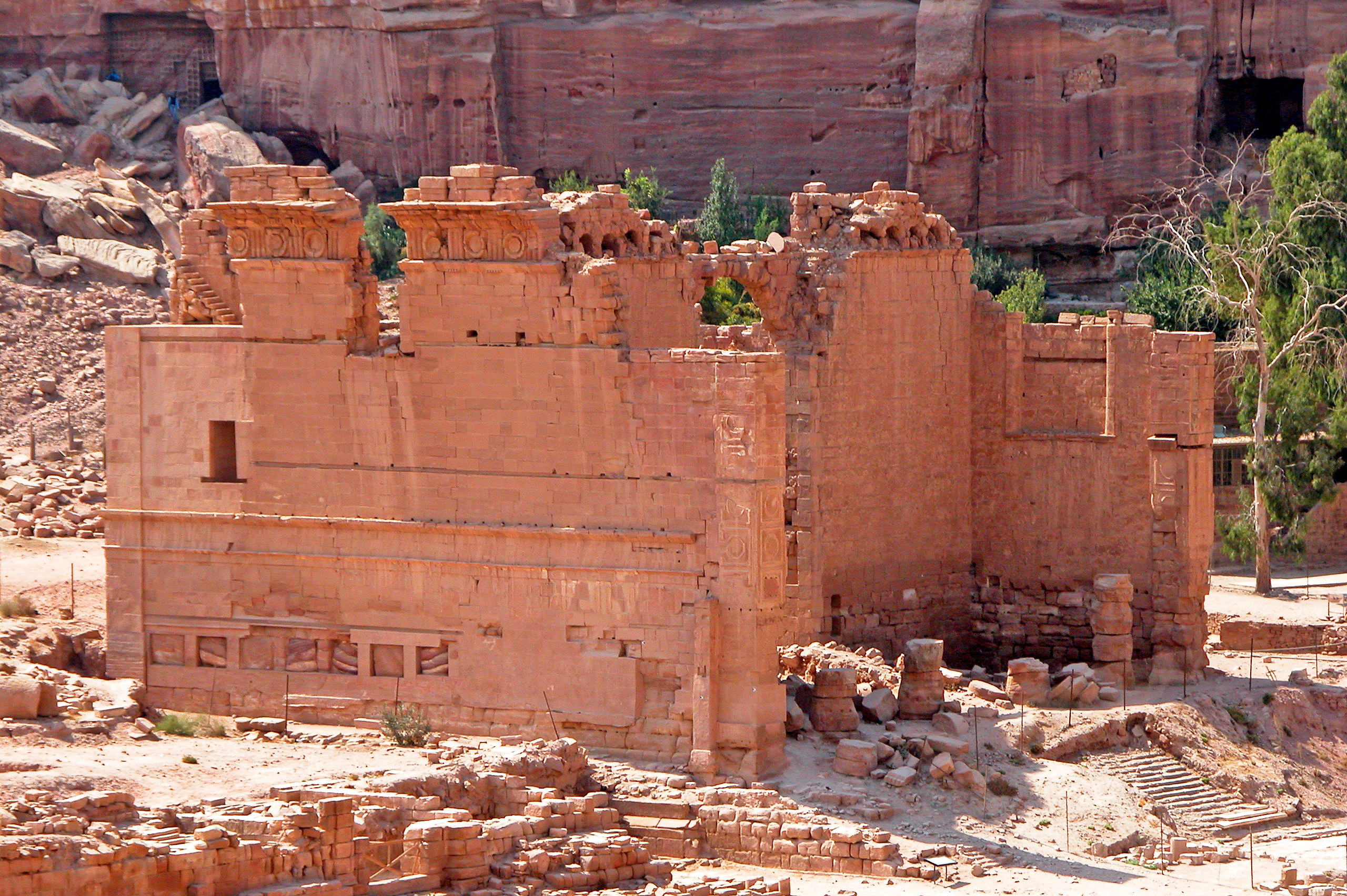
- Fig. 0.1 - Photo of Qasr Bint
from Augé et al. (2016)
 Fig. 0.1
Photo of the sanctuary
Augé et al. (2016) - Qasr Bint in Google Earth
 Qasr Bint location in Google Earth
click on image to explore this site on a new tab in Google Earth
- Map of Qasr al-Bint
and environs from Tholbecq et. al. (2021)
 Qasr al-Bint in the Roman period. General plan and location of surveys
(MAFP/M. Belarbi/Th. Fournet)
Tholbecq et. al. (2021) - Fig. 1 - Plan of sectors
excavated in 2017 from Tholbecq et. al. (2018)
 Fig. 1
Plan of sectors excavated during the fall 2017 campaign
(Drawing T. Fournet, ©MAFP)
Tholbecq et. al. (2018) - Fig. 1 - Plan of sectors
excavated in 2018 from Tholbecq et. al. (2019)
 Fig. 1
Plan of sectors excavated during the fall 2018 campaign
(Drawing T. Fournet, ©MAFP)
Tholbecq et. al. (2019) - Fig. 1 - Plan of sectors
excavated in 2023 from Tholbecq et. al. (2023)
 Fig. 1
Petra, general plan of the Qasr al-Bint sector, location of operations carried out in 2023
(T. Fournet/ M. Belarbi, MAFP)
Tholbecq et. al. (2023) - Plan of Qasr al-Bint
from Fournet and Renel (2019)
 Plan of Qasr al-Bint
Fournet and Renel (2019)
- Map of Qasr al-Bint
and environs from Tholbecq et. al. (2021)
Qasr al-Bint in the Roman period. General plan and location of surveys
(MAFP/M. Belarbi/Th. Fournet)
Tholbecq et. al. (2021) - Fig. 1 - Plan of sectors
excavated in 2017 from Tholbecq et. al. (2018)
Fig. 1
Plan of sectors excavated during the fall 2017 campaign
(Drawing T. Fournet, ©MAFP)
Tholbecq et. al. (2018) - Fig. 1 - Plan of sectors
excavated in 2018 from Tholbecq et. al. (2019)
Fig. 1
Plan of sectors excavated during the fall 2018 campaign
(Drawing T. Fournet, ©MAFP)
Tholbecq et. al. (2019) - Fig. 1 - Plan of sectors
excavated in 2023 from Tholbecq et. al. (2023)
Fig. 1
Petra, general plan of the Qasr al-Bint sector, location of operations carried out in 2023
(T. Fournet/ M. Belarbi, MAFP)
Tholbecq et. al. (2023) - Plan of Qasr al-Bint
from Fournet and Renel (2019)
Plan of Qasr al-Bint
Fournet and Renel (2019)
- Fig. 3.2 - Plan of staircase
from Augé et al. (2016)
 Fig. 3.2
Qasr al-Bint: plan of the assembled surveys of the gutters and the staircase (scale: 1/150)
(© MAFP, CAD: C. March)
Augé et al. (2016) - Elevation of western
monumental stairway from Fournet and Renel (2019)
 Elevation of western monumental stairway
MAFP 2018, TF/MB
Fournet and Renel (2019) - Reconstruction of stairway
from Fournet and Renel (2019)
 Reconstruction of stairway
Fournet and Renel (2019) - Fig. 0.3 - Plan of the
western zone from Augé et al. (2016)
 Fig. 0.3
General plan of the western zone
(© MAFP, CAD: C. March)
Augé et al. (2016) - Fig. 16 - Plan of the palace
sector of Qasr Bint from Tholbecq et. al. (2023)
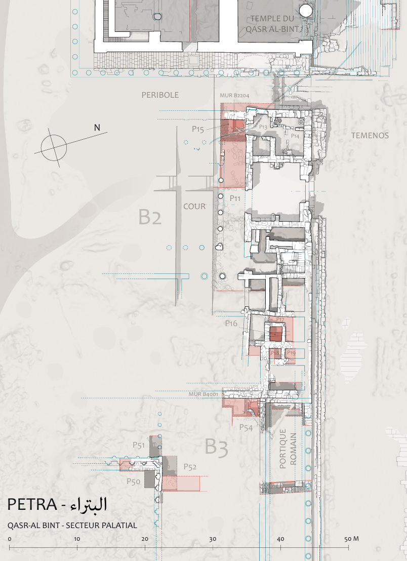 Fig. 16
General plan of the palace sector of Qasr al-Bint sector, location of operations carried out in Fall 2023
(T. Fournet/M. Belarbi/ P. Piraud-Fournet, MAFP)
Tholbecq et. al. (2023) - Simplified plan of "B" building
from Fournet and Renel (2019)
 Simplified plan of "B" building
MAFP, 2017
Fournet and Renel (2019) - Fig. 6.38 - General plan
of western part of the Qasr el-Bint Temenos from Rababeh (2005)
 Fig. 6.38
General plan of western part of the Qasr el-Bint Temenos
(Zayadine et al. 2003: 8)
Rababeh (2005) - Fig. 6.40a - Detailed plan
from Rababeh (2005)
 Fig. 6.40a
Detailed plan
(Larché and Zayadine 2003: Fig.221)
Rababeh (2005) - Fig. 6.52b - East-West
section of reconstructed temple from Rababeh (2005)
 Fig. 6.52b
East-West section of reconstructed roof of Qasr el-Bint as Larché and Zayadine suggested in final report
(Larche in Zayadine et al. 2003: Fig. 15)
Rababeh (2005) - Fig. 4.3 - Plan of the great altar
from Augé et al. (2016)
 Fig. 4.3
The great altar: plans from the assembled surveys of P. Parr's surveys and sections (scale: 1/100)
(© MAFP, CAD: C. March)
Augé et al. (2016) - Fig. 4.4 - Face of the great altar
from Augé et al. (2016)
 Fig. 4.4
The great altar: east, west and north faces of the assembled statements (scale: 1/100)
(© MAFP, CAD: C. March)
Augé et al. (2016) - Fig. 4 - scree of the
apse monument from Tholbecq et al. (2022)
 Fig. 4
Overall plan of the scree of the apse monument at the end of the October 2022 campaign, superposition of all the layers of blocks in the falling position. In blue the elements of marble statuary, in green the blocks from the temple of Qasr al-Bint
(T. Fournet / C. March / M. Belarbi, MAFP)
Tholbecq et al. (2022)
- Fig. 3.2 - Plan of staircase
from Augé et al. (2016)
Fig. 3.2
Qasr al-Bint: plan of the assembled surveys of the gutters and the staircase (scale: 1/150)
(© MAFP, CAD: C. March)
Augé et al. (2016) - Elevation of western
monumental stairway from Fournet and Renel (2019)
Elevation of western monumental stairway
MAFP 2018, TF/MB
Fournet and Renel (2019) - Reconstruction of stairway
from Fournet and Renel (2019)
Reconstruction of stairway
Fournet and Renel (2019) - Fig. 16 - Plan of the palace
sector of Qasr Bint from Tholbecq et. al. (2023)
Fig. 16
General plan of the palace sector of Qasr al-Bint sector, location of operations carried out in Fall 2023
(T. Fournet/M. Belarbi/ P. Piraud-Fournet, MAFP)
Tholbecq et. al. (2023) - Fig. 0.3 - Plan of the
western zone from Augé et al. (2016)
Fig. 0.3
General plan of the western zone
(© MAFP, CAD: C. March)
Augé et al. (2016) - Simplified plan of "B" building
from Fournet and Renel (2019)
Simplified plan of "B" building
MAFP, 2017
Fournet and Renel (2019) - Fig. 6.38 - General plan
of western part of the Qasr el-Bint Temenos from Rababeh (2005)
Fig. 6.38
General plan of western part of the Qasr el-Bint Temenos
(Zayadine et al. 2003: 8)
Rababeh (2005) - Fig. 6.40a - Detailed plan
from Rababeh (2005)
Fig. 6.40a
Detailed plan
(Larché and Zayadine 2003: Fig.221)
Rababeh (2005) - Fig. 6.52b - East-West
section of reconstructed temple from Rababeh (2005)
Fig. 6.52b
East-West section of reconstructed roof of Qasr el-Bint as Larché and Zayadine suggested in final report
(Larche in Zayadine et al. 2003: Fig. 15)
Rababeh (2005) - Fig. 4.3 - Plan of the great altar
from Augé et al. (2016)
Fig. 4.3
The great altar: plans from the assembled surveys of P. Parr's surveys and sections (scale: 1/100)
(© MAFP, CAD: C. March)
Augé et al. (2016) - Fig. 4.4 - Face of the great altar
from Augé et al. (2016)
Fig. 4.4
The great altar: east, west and north faces of the assembled statements (scale: 1/100)
(© MAFP, CAD: C. March)
Augé et al. (2016) - Fig. 4 - scree of the
apse monument from Tholbecq et al. (2022)
Fig. 4
Overall plan of the scree of the apse monument at the end of the October 2022 campaign, superposition of all the layers of blocks in the falling position. In blue the elements of marble statuary, in green the blocks from the temple of Qasr al-Bint
(T. Fournet / C. March / M. Belarbi, MAFP)
Tholbecq et al. (2022)
- Fig. 1 - Areas B2 and
B3 from Tholbecq et al. (2024)
 Fig. 1
Map of the areas examined in the 2024 spring campaign
(T. Fournet / M. Belarbi/ P. Piraud-Fournet, MAFP)
Tholbecq et al. (2024) - Fig. 24 - Phases of
Area B2 from Tholbecq et al. (2024)
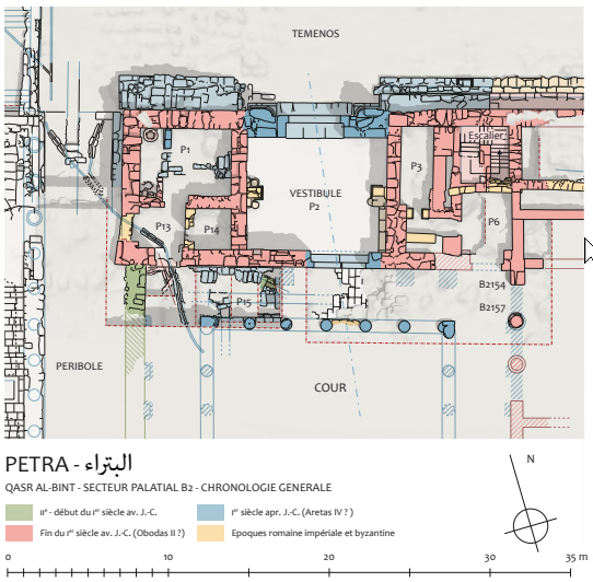 Fig. 24
Plan of part of the NE sector (B2) with proposed phasing
(Th. Fournet / M. Belarbi/ P. Piraud-Fournet, MAFP 2024)
Tholbecq et al. (2024)
- Fig. 1 - Areas B2 and
B3 from Tholbecq et al. (2024)
Fig. 1
Map of the areas examined in the 2024 spring campaign
(T. Fournet / M. Belarbi/ P. Piraud-Fournet, MAFP)
Tholbecq et al. (2024) - Fig. 24 - Phases of
Area B2 from Tholbecq et al. (2024)
Fig. 24
Plan of part of the NE sector (B2) with proposed phasing
(Th. Fournet / M. Belarbi/ P. Piraud-Fournet, MAFP 2024)
Tholbecq et al. (2024)
- Cover Page - Qasr al-Bint sector
in the Roman era from Tholbecq et. al. (2017)
 Cover page
The Qasr al-Bint sector in the Roman era
(Thibaud Fournet, 2017)
Tholbecq et. al. (2017) - Fig. 6.52a - Axonometric drawing
of reconstructed temple from Rababeh (2005)
 Fig. 6.52a
Axonometric drawing of reconstructed roof of Qasr el-Bint as Larché and Zayadine suggested in final report
(Larche in Zayadine et al. 2003: Fig. 220)
Rababeh (2005) - Fig. 6.53a - Cutaway Axonometric
drawing of reconstructed temple from Rababeh (2005)
 Fig. 6.53a
Axonometric reconstruction suggested here
Rababeh (2005) - Fig. 6.41d - Isometric of southeast
corner showing the cavity walls and stairs from Rababeh (2005)
 Fig. 6.41d
Isometric of southeast angle showing the cavity walls including the stairs
(Wright 1961a: Fig. 5)
Rababeh (2005)
- Fig. 10 - Section of western
peribole from Tholbecq et. al. (2019)
 Fig. 10
East-west section of the western peribole.
(M. Bélarbi, C. Besnier, F. Renel)
Tholbecq et. al. (2019) - Fig. 3 - E-W section
of the fill of the western peribole with an earthquake destruction layer from Renel (2013)
 Fig. 3
East-west section of the fill of the western peribole of the Qasr al-Bint temple.
(© M. Belarbi, MF-PQB)
Renel (2013) - Fig. 9 - Reconstruction of
southern half of the main facade of the apse monument from Tholbecq et. al. (2023)
 Fig. 9
Proposal for the restitution in principle of the southern half of the main facade of the apse monument, simplified working hypothesis
(T. Fournet, MAFP).
Tholbecq et. al. (2023)
- Fig. 5.30b - Torsion response
through as-symmetrical building from Rababeh (2005)
 Fig. 5.30b
The torsion response through as-symmetrical building
(Arnold 1989: Fig.5.17)
Rababeh (2005) - Fig. 5.30c - Torsion response
of Qasr el-Bint as symmetrical building from Rababeh (2005)
 Fig. 5.30c
The torsion response in the Qasr el-Bint as symmetrical building.
Rababeh (2005)
- Fig. 11 - Stratigraphy at the base
of the western péribole (περίβόλος) from Tholbecq et al (2019:36-37)
 Figure 11
Stratigraphy at the base of the western péribole (περίβόλος) of the Temple
Tholbecq et al (2019) - © MAFP - Fig. 12 - View of the Stratum F1082
from Tholbecq et al (2019:36-37)
 Figure 12
View of the Stratum F1082
Tholbecq et al (2019) - © MAFP - Fig. 4 - Blocks from collapse
of the apse from Renel (2013)
 Fig. 4
View of the pile of blocks linked to the fall of the elevations of the apse monument during the earthquake of 363.
(© L. Borel, MFPQB)
Renel (2013) - Fig. 3 - Destruction layers
of the western peribole from Tholbecq et. al. (2023)
 Fig. 3
The western peribole of Qasr al-Bint, towards the south, destruction layers
(F. Renel, MAFP)
Tholbecq et. al. (2023) - Destruction layers of the western
peribole - photo by JW
 The western peribole of Qasr al-Bint, destruction layers
Click on image to open in a new tab
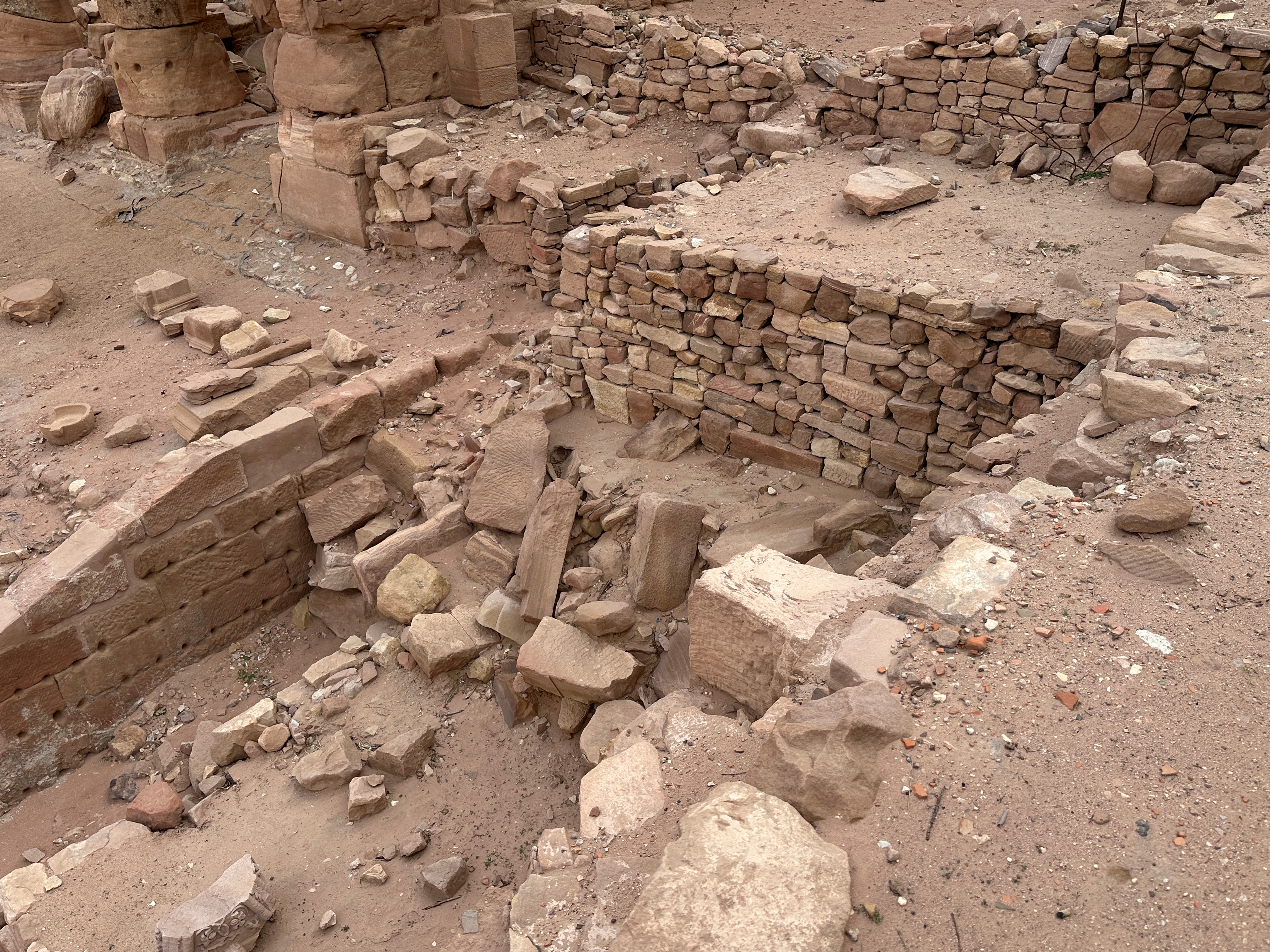
Photo by Jefferson Williams - 22 Jan. 2026 - Destruction layers of the western
peribole - photo by JW
 The western peribole of Qasr al-Bint, destruction layers
Click on image to open in a new tab
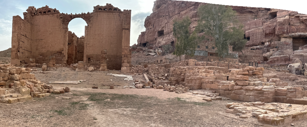
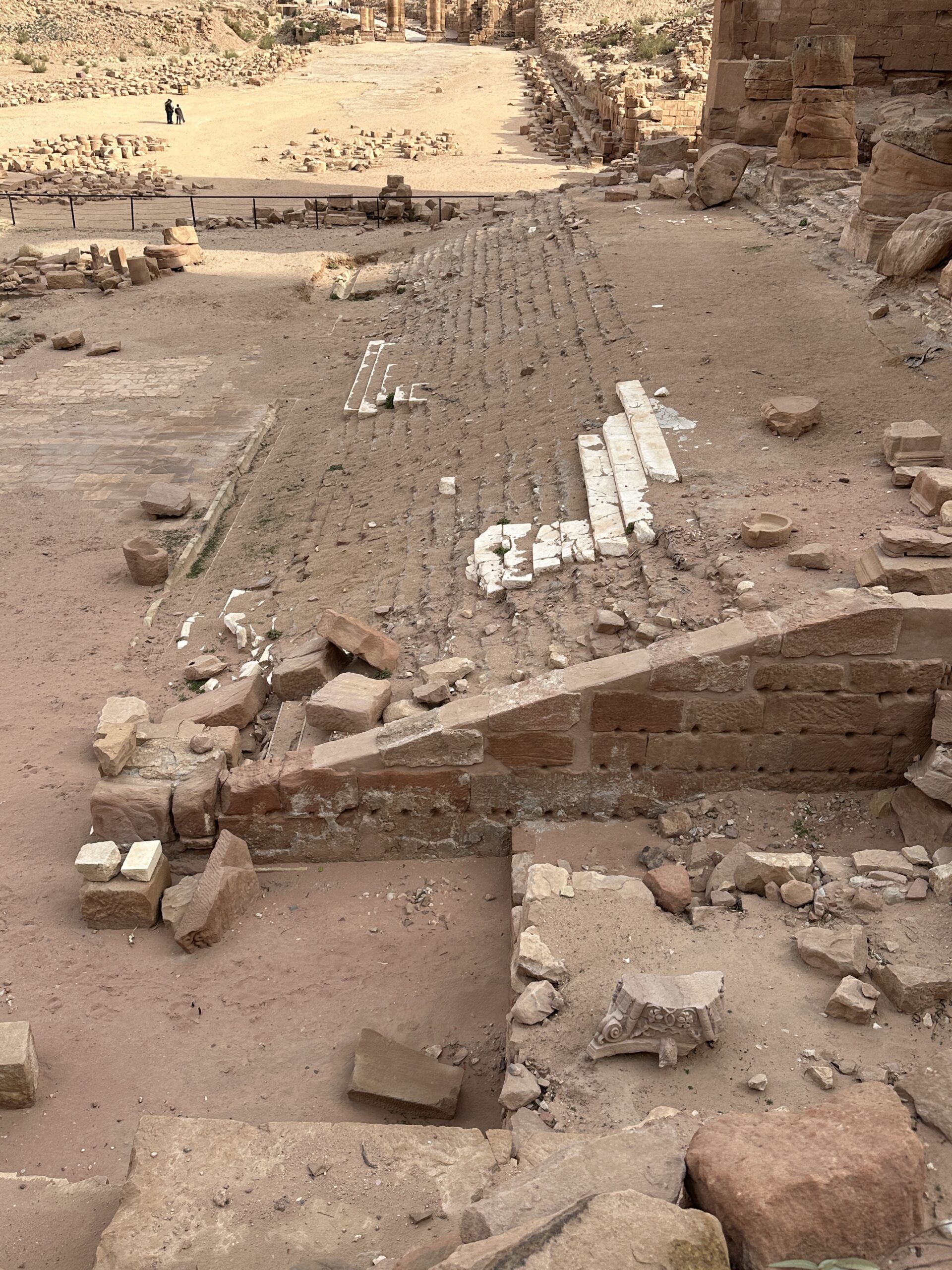
Photo by Jefferson Williams - 22 Jan. 2026 - Monumental Staircase of Qasr Bint
- photo by JW
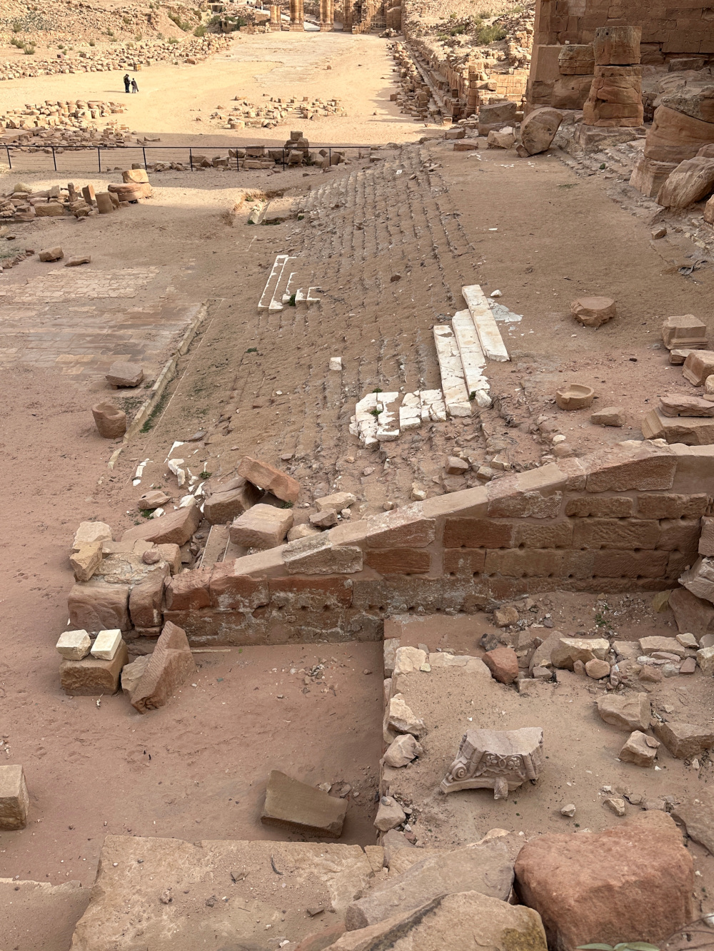 Monumental Staircase
Click on image to open in a new tab
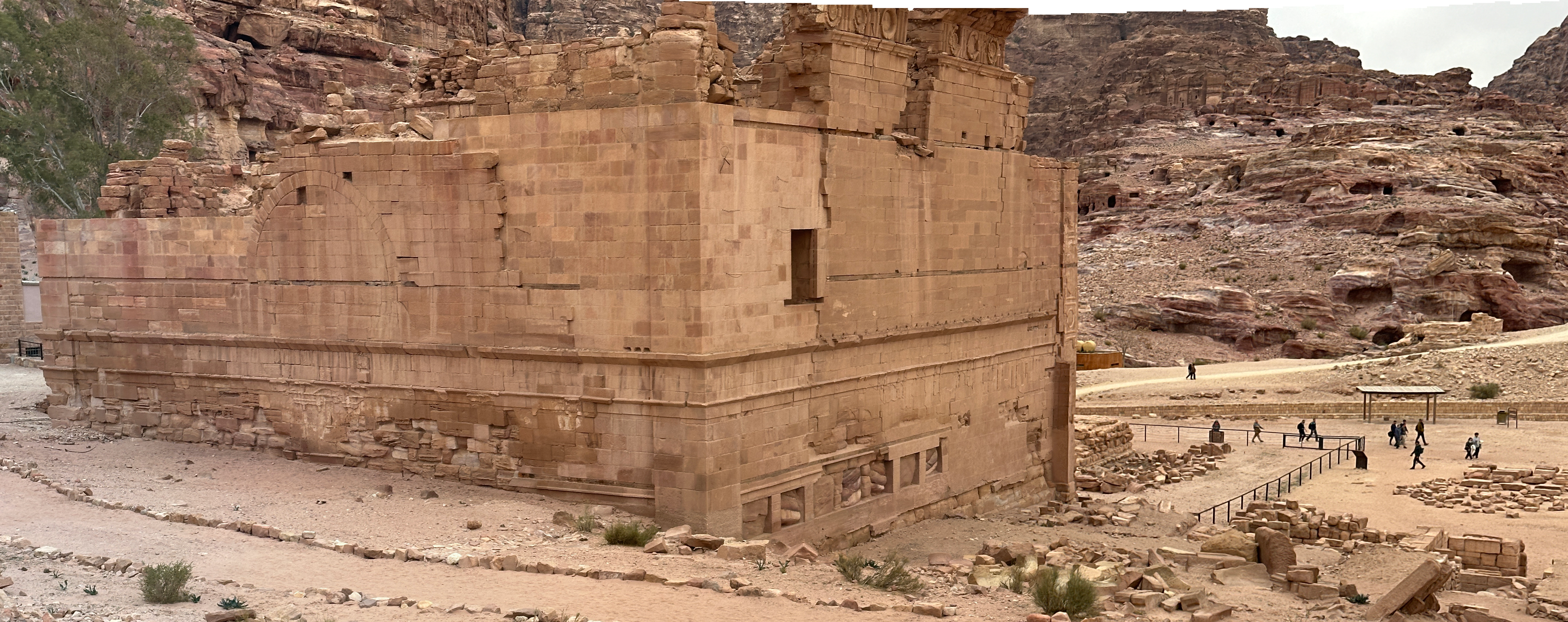
Photo by Jefferson Williams - 22 Jan. 2026 - Side and Rear panorama of Qasr Bint
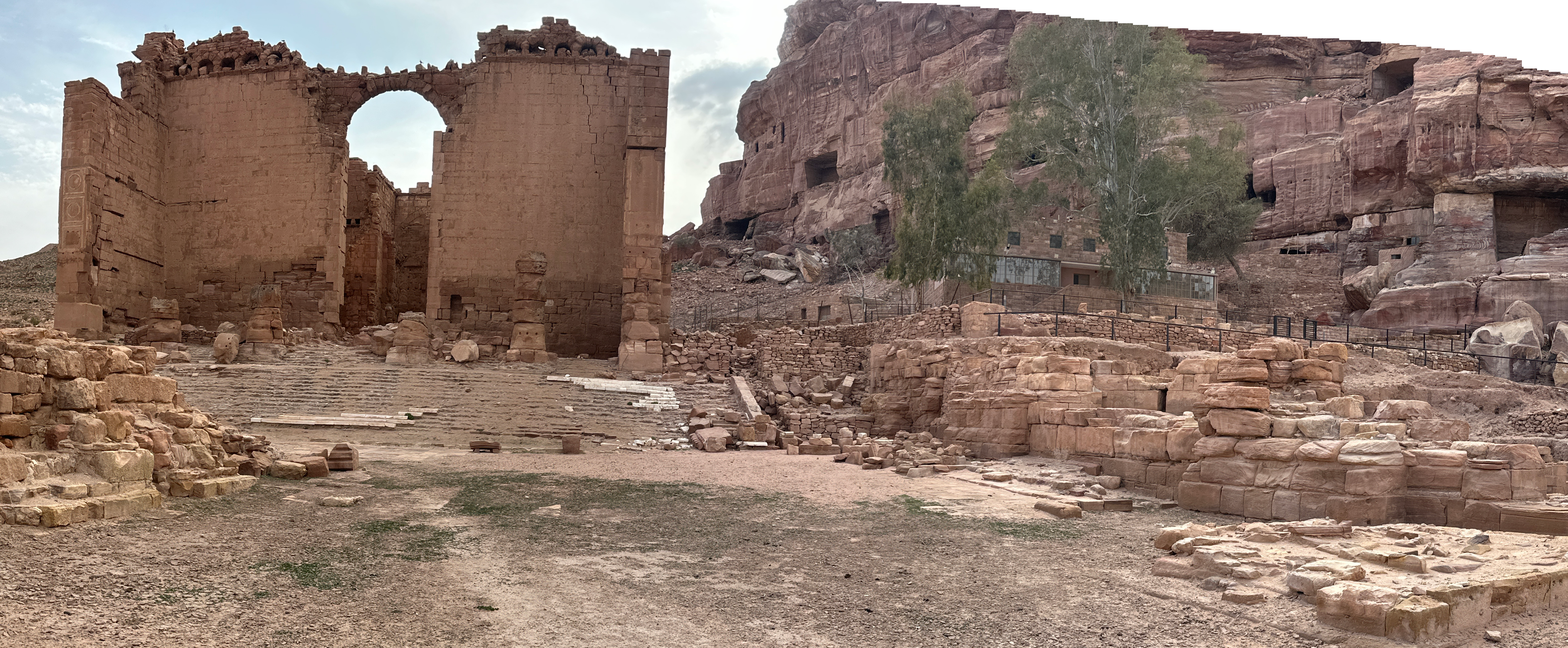
- photo by JW
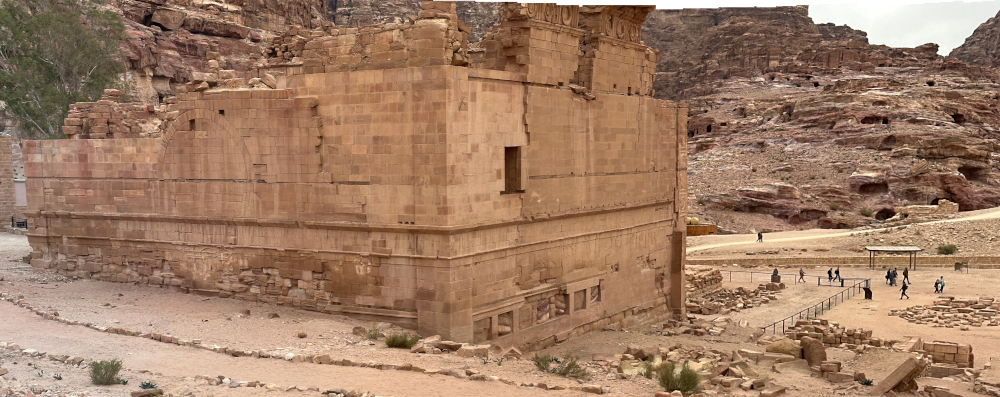 Side and Rear panorama of Qasr Bint
Click on image to open in a new tab
Photo by Jefferson Williams - 22 Jan. 2026 - Side panorama of Qasr Bint
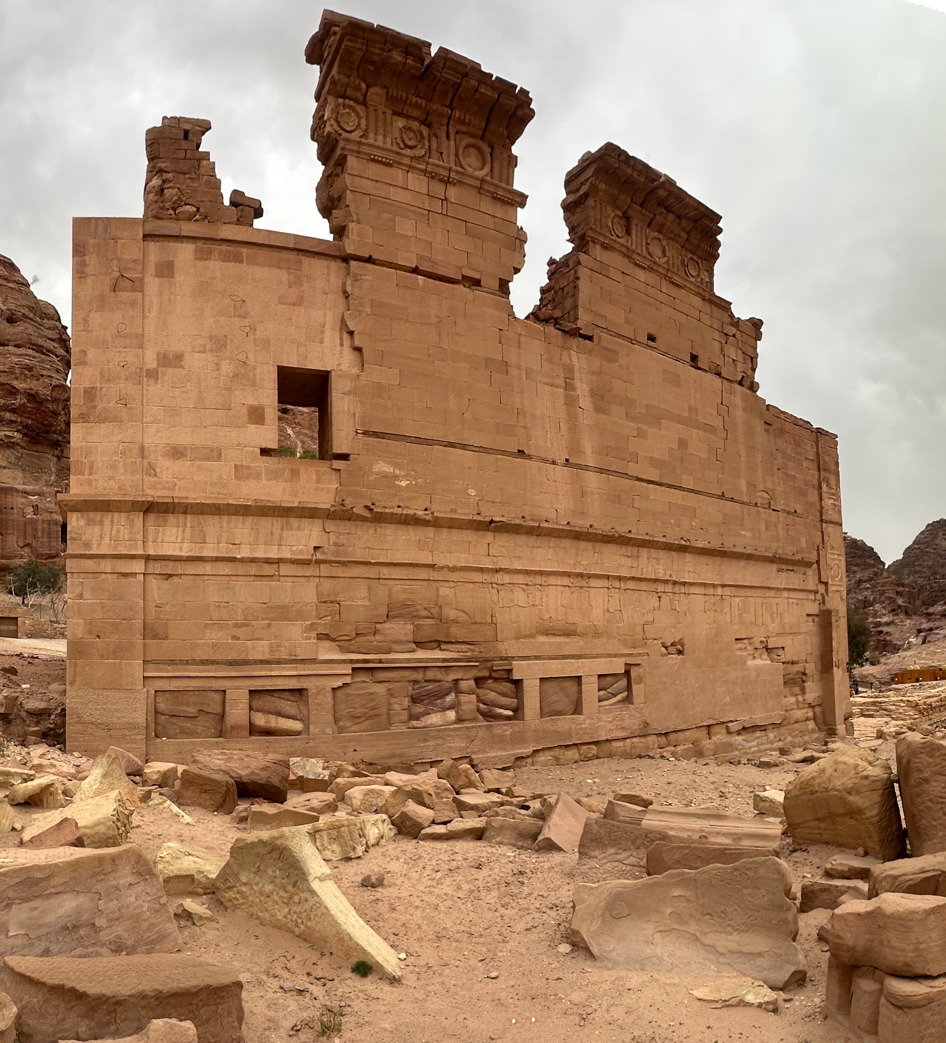
- photo by JW
 Side panorama of Qasr Bint
Click on image to open in a new tab
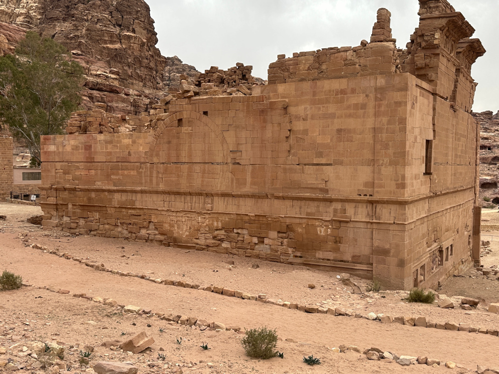
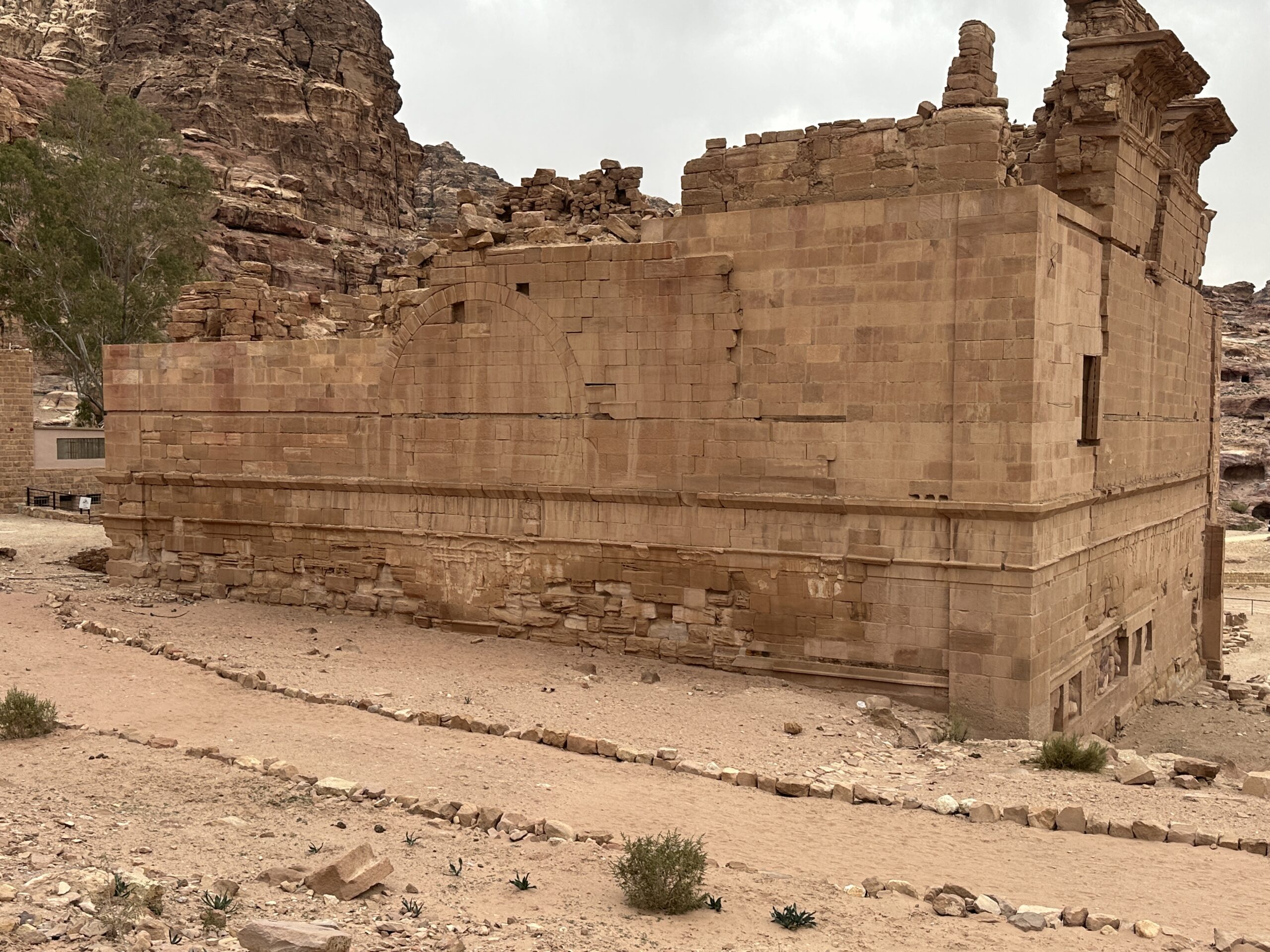
Photo by Jefferson Williams - 22 Jan. 2026 - Side photo of Qasr Bint - photo
by JW
 Side photo of Qasr Bint
Click on image to open in a new tab
Photo by Jefferson Williams - 22 Jan. 2026 - Rear photo of Qasr Bint - photo by
JW
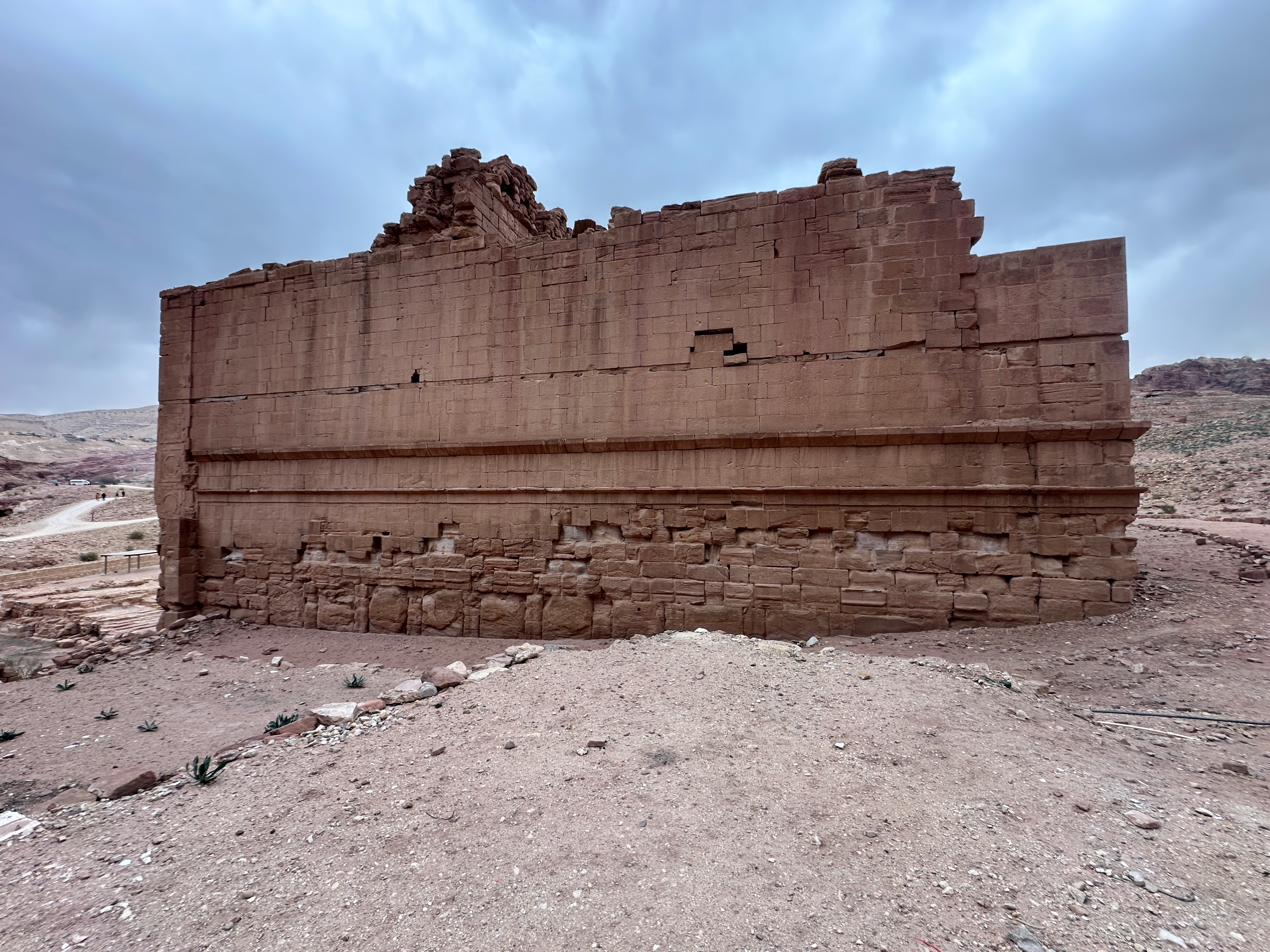
 Rear photo of Qasr Bint
Click on image to open in a new tab
Photo by Jefferson Williams - 22 Jan. 2026 - Front photo of Qasr Bint - photo by
JW
 Front photo of Qasr Bint
Click on image to open in a new tab
Photo by Jefferson Williams - 22 Jan. 2026 - Fig. 10 - Overview of
destruction layer from Tholbecq et. al. (2023)
 Fig. 10
Overview of the ancient destruction level
(F. Renel, MAFP).
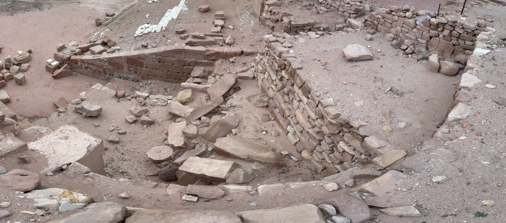
Tholbecq et. al. (2023) - Fig. 18 - Upper stratigraphic
sequence of P15 in the palace sector from Tholbecq et. al. (2023)
 Fig. 18
view of the upper stratigraphic sequence of space P15, southern section
(F. Renel, MAFP)
Tholbecq et. al. (2023) - Fig. 19 - Fallen blocks
from Tholbecq et. al. (2023)
 Fig. 19
the level of fallen blocks B2165-2173, towards the northeast
(F. Renel, MAFP)
Tholbecq et. al. (2023) - Fig. 24 - Fallen capitals
from Tholbecq et. al. (2023)
 Fig. 24
detail of the elements of Corinthian capitals in fallen position in destruction layer B2165-2173
(T. Fournet, MAFP)
Tholbecq et. al. (2023) - Fig. 40 - Fallen blocks
in room P16 from Tholbecq et. al. (2023)
 Fig. 40
fallen blocks (B2171) present in the upper filling of room P16
(F. Renel, MAFP)
Tholbecq et. al. (2023) - Fig. 41 - Fallen architecture
from Tholbecq et. al. (2023)
 Fig. 41
detail of a stucco preserved on its facing block (B2171)
(F. Renel, MAFP)
Tholbecq et. al. (2023)

- Fig. 11 - Stratigraphy at the base
of the western péribole (περίβόλος) from Tholbecq et al (2019:36-37)
Figure 11
Stratigraphy at the base of the western péribole (περίβόλος) of the Temple
Tholbecq et al (2019) - © MAFP - Fig. 12 - View of the Stratum F1082
from Tholbecq et al (2019:36-37)
Figure 12
View of the Stratum F1082
Tholbecq et al (2019) - © MAFP - Fig. 4 - Blocks from collapse
of the apse from Renel (2013)
Fig. 4
View of the pile of blocks linked to the fall of the elevations of the apse monument during the earthquake of 363.
(© L. Borel, MFPQB)
Renel (2013) - Fig. 3 - Destruction layers
of the western peribole from Tholbecq et. al. (2023)
Fig. 3
The western peribole of Qasr al-Bint, towards the south, destruction layers
(F. Renel, MAFP)
Tholbecq et. al. (2023) - Destruction layers of the western
peribole - photo by JW
The western peribole of Qasr al-Bint, destruction layers
Click on image to open in a new tab
Photo by Jefferson Williams - 22 Jan. 2026 - Destruction layers of the western
peribole - photo by JW
The western peribole of Qasr al-Bint, destruction layers
Click on image to open in a new tab
Photo by Jefferson Williams - 22 Jan. 2026 - Monumental Staircase of Qasr Bint
- photo by JW
Monumental Staircase
Click on image to open in a new tab
Photo by Jefferson Williams - 22 Jan. 2026 - Side and Rear panorama of Qasr Bint
- photo by JW
Side and Rear panorama of Qasr Bint
Click on image to open in a new tab
Photo by Jefferson Williams - 22 Jan. 2026 - Side panorama of Qasr Bint
- photo by JW
Side panorama of Qasr Bint
Click on image to open in a new tab
Photo by Jefferson Williams - 22 Jan. 2026 - Side photo of Qasr Bint - photo
by JW
Side photo of Qasr Bint
Click on image to open in a new tab
Photo by Jefferson Williams - 22 Jan. 2026 - Rear photo of Qasr Bint - photo by
JW
Rear photo of Qasr Bint
Click on image to open in a new tab
Photo by Jefferson Williams - 22 Jan. 2026 - Front photo of Qasr Bint - photo by
JW
Front photo of Qasr Bint
Click on image to open in a new tab
Photo by Jefferson Williams - 22 Jan. 2026 - Fig. 10 - Overview of
destruction layer from Tholbecq et. al. (2023)
Fig. 10
Overview of the ancient destruction level
(F. Renel, MAFP).
Tholbecq et. al. (2023) - Fig. 18 - Upper stratigraphic
sequence of P15 in the palace sector from Tholbecq et. al. (2023)
Fig. 18
view of the upper stratigraphic sequence of space P15, southern section
(F. Renel, MAFP)
Tholbecq et. al. (2023) - Fig. 19 - Fallen blocks
from Tholbecq et. al. (2023)
Fig. 19
the level of fallen blocks B2165-2173, towards the northeast
(F. Renel, MAFP)
Tholbecq et. al. (2023) - Fig. 24 - Fallen capitals
from Tholbecq et. al. (2023)
Fig. 24
detail of the elements of Corinthian capitals in fallen position in destruction layer B2165-2173
(T. Fournet, MAFP)
Tholbecq et. al. (2023) - Fig. 40 - Fallen blocks
in room P16 from Tholbecq et. al. (2023)
Fig. 40
fallen blocks (B2171) present in the upper filling of room P16
(F. Renel, MAFP)
Tholbecq et. al. (2023) - Fig. 41 - Fallen architecture
from Tholbecq et. al. (2023)
Fig. 41
detail of a stucco preserved on its facing block (B2171)
(F. Renel, MAFP)
Tholbecq et. al. (2023)
- from Schmid (1995)
- Ez-Zantur Excavations utilized Nabatean fineware chronology of Schmid (2000) - which I don't currently have access to
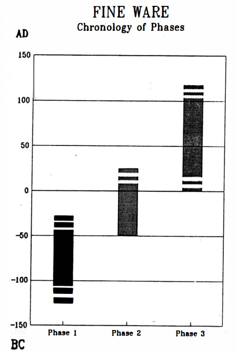
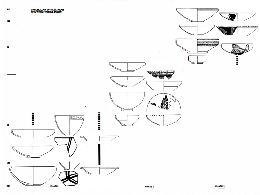
Left
Chronology of Nabatean finewares
Right
Typology and chronology of the Nabataean fine ware
Both from Schmid (1995)
- Fig. 6.38 - General plan
of western part of the Qasr el-Bint Temenos from Rababeh (2005)
Fig. 6.38
General plan of western part of the Qasr el-Bint Temenos
(Zayadine et al. 2003: 8)
Rababeh (2005) - Fig. 6.40a - Detailed plan
from Rababeh (2005)
Fig. 6.40a
Detailed plan
(Larché and Zayadine 2003: Fig.221)
Rababeh (2005) - Fig. 6.52b - East-West
section of reconstructed temple from Rababeh (2005)
Fig. 6.52b
East-West section of reconstructed roof of Qasr el-Bint as Larché and Zayadine suggested in final report
(Larche in Zayadine et al. 2003: Fig. 15)
Rababeh (2005) - Fig. 6.52a - Axonometric drawing
of reconstructed temple from Rababeh (2005)
Fig. 6.52a
Axonometric drawing of reconstructed roof of Qasr el-Bint as Larché and Zayadine suggested in final report
(Larche in Zayadine et al. 2003: Fig. 220)
Rababeh (2005) - Fig. 6.53a - Cutaway Axonometric
drawing of reconstructed temple from Rababeh (2005)
Fig. 6.53a
Axonometric reconstruction suggested here
Rababeh (2005) - Fig. 6.41d - Isometric of southeast
corner showing the cavity walls and stairs from Rababeh (2005)
Fig. 6.41d
Isometric of southeast angle showing the cavity walls including the stairs
(Wright 1961a: Fig. 5)
Rababeh (2005)
- Fig. 6.38 - General plan
of western part of the Qasr el-Bint Temenos from Rababeh (2005)
Fig. 6.38
General plan of western part of the Qasr el-Bint Temenos
(Zayadine et al. 2003: 8)
Rababeh (2005) - Fig. 6.40a - Detailed plan
from Rababeh (2005)
Fig. 6.40a
Detailed plan
(Larché and Zayadine 2003: Fig.221)
Rababeh (2005) - Fig. 6.52b - East-West
section of reconstructed temple from Rababeh (2005)
Fig. 6.52b
East-West section of reconstructed roof of Qasr el-Bint as Larché and Zayadine suggested in final report
(Larche in Zayadine et al. 2003: Fig. 15)
Rababeh (2005) - Fig. 6.52a - Axonometric drawing
of reconstructed temple from Rababeh (2005)
Fig. 6.52a
Axonometric drawing of reconstructed roof of Qasr el-Bint as Larché and Zayadine suggested in final report
(Larche in Zayadine et al. 2003: Fig. 220)
Rababeh (2005) - Fig. 6.53a - Cutaway Axonometric
drawing of reconstructed temple from Rababeh (2005)
Fig. 6.53a
Axonometric reconstruction suggested here
Rababeh (2005)
- Fig. 10 - Section of western
peribole from Tholbecq et. al. (2019)
Fig. 10
East-west section of the western peribole.
(M. Bélarbi, C. Besnier, F. Renel)
Tholbecq et. al. (2019) - Fig. 11 - Stratigraphy at the base
of the western péribole (περίβόλος) from Tholbecq et al (2019:36-37)
Figure 11
Stratigraphy at the base of the western péribole (περίβόλος) of the Temple
Tholbecq et al (2019) - © MAFP - Fig. 12 - View of the Stratum F1082
from Tholbecq et al (2019:36-37)
Figure 12
View of the Stratum F1082
Tholbecq et al (2019) - © MAFP
- Fig. 9 - level of spoliation
peribole from the Byzantine period from Tholbecq et. al. (2019)
 Fig. 9
View of the level of spoliation from the Byzantine period revealed in the western peribole of the temple.
© MAFP
Tholbecq et. al. (2019) - Fig. 10 - Section of western
peribole from Tholbecq et. al. (2019)
Fig. 10
East-west section of the western peribole.
(M. Bélarbi, C. Besnier, F. Renel)
Tholbecq et. al. (2019) - Fig. 11 - Stratigraphy at the base
of the western péribole (περίβόλος) from Tholbecq et al (2019:36-37)
Figure 11
Stratigraphy at the base of the western péribole (περίβόλος) of the Temple
Tholbecq et al (2019) - © MAFP - Fig. 12 - View of the Strata F1082
from Tholbecq et al (2019:36-37)
Figure 12
View of the Strata F1082
Tholbecq et al (2019) - © MAFP
- Fig. 1 - Plan of sectors
excavated in 2023 from Tholbecq et. al. (2023)
Fig. 1
Petra, general plan of the Qasr al-Bint sector, location of operations carried out in 2023
(T. Fournet/ M. Belarbi, MAFP)
Tholbecq et. al. (2023) - Fig. 2 - Overview of sector
excavated in 2023 from Tholbecq et. al. (2023)
 Fig. 1
Overview of the sector at the end of the [Spring 2023] campaign, towards the southwest
(T. Fournet 2023, CNRS / MAFP)
Tholbecq et. al. (2023) - Fig. 3 - Destruction layers
of the western peribole from Tholbecq et. al. (2023)
Fig. 3
The western peribole of Qasr al-Bint, towards the south, destruction layers
(F. Renel, MAFP)
Tholbecq et. al. (2023) - Fig. 9 - Reconstruction of
southern half of the main facade of the apse monument from Tholbecq et. al. (2023)
Fig. 9
Proposal for the restitution in principle of the southern half of the main facade of the apse monument, simplified working hypothesis
(T. Fournet, MAFP).
Tholbecq et. al. (2023) - Fig. 10 - Overview of
destruction layer from Tholbecq et. al. (2023)
Fig. 10
Overview of the ancient destruction level
(F. Renel, MAFP).
Tholbecq et. al. (2023) - Fig. 16 - Plan of the palace
sector of Qasr Bint from Tholbecq et. al. (2023)
Fig. 16
General plan of the palace sector of Qasr al-Bint sector, location of operations carried out in Fall 2023
(T. Fournet/M. Belarbi/ P. Piraud-Fournet, MAFP)
Tholbecq et. al. (2023) - Fig. 18 - Upper stratigraphic
sequence of P15 in the palace sector from Tholbecq et. al. (2023)
Fig. 18
view of the upper stratigraphic sequence of space P15, southern section
(F. Renel, MAFP)
Tholbecq et. al. (2023) - Fig. 19 - Fallen blocks
from Tholbecq et. al. (2023)
Fig. 19
the level of fallen blocks B2165-2173, towards the northeast
(F. Renel, MAFP)
Tholbecq et. al. (2023) - Fig. 24 - Fallen capitals
from Tholbecq et. al. (2023)
Fig. 24
detail of the elements of Corinthian capitals in fallen position in destruction layer B2165-2173
(T. Fournet, MAFP)
Tholbecq et. al. (2023) - Fig. 40 - Fallen blocks
in room P16 from Tholbecq et. al. (2023)
Fig. 40
fallen blocks (B2171) present in the upper filling of room P16
(F. Renel, MAFP)
Tholbecq et. al. (2023) - Fig. 41 - Fallen architecture
from Tholbecq et. al. (2023)
Fig. 41
detail of a stucco preserved on its facing block (B2171)
(F. Renel, MAFP)
Tholbecq et. al. (2023)
- Fig. 1 - Plan of sectors
excavated in 2023 from Tholbecq et. al. (2023)
Fig. 1
Petra, general plan of the Qasr al-Bint sector, location of operations carried out in 2023
(T. Fournet/ M. Belarbi, MAFP)
Tholbecq et. al. (2023) - Fig. 2 - Overview of sector
excavated in 2023 from Tholbecq et. al. (2023)
Fig. 1
Overview of the sector at the end of the [Spring 2023] campaign, towards the southwest
(T. Fournet 2023, CNRS / MAFP)
Tholbecq et. al. (2023) - Fig. 3 - Destruction layers
of the western peribole from Tholbecq et. al. (2023)
Fig. 3
The western peribole of Qasr al-Bint, towards the south, destruction layers
(F. Renel, MAFP)
Tholbecq et. al. (2023) - Fig. 9 - Reconstruction of
southern half of the main facade of the apse monument from Tholbecq et. al. (2023)
Fig. 9
Proposal for the restitution in principle of the southern half of the main facade of the apse monument, simplified working hypothesis
(T. Fournet, MAFP).
Tholbecq et. al. (2023) - Fig. 10 - Overview of
destruction layer from Tholbecq et. al. (2023)
Fig. 10
Overview of the ancient destruction level
(F. Renel, MAFP).
Tholbecq et. al. (2023) - Fig. 16 - Plan of the palace
sector of Qasr Bint from Tholbecq et. al. (2023)
Fig. 16
General plan of the palace sector of Qasr al-Bint sector, location of operations carried out in Fall 2023
(T. Fournet/M. Belarbi/ P. Piraud-Fournet, MAFP)
Tholbecq et. al. (2023) - Fig. 18 - Upper stratigraphic
sequence of P15 in the palace sector from Tholbecq et. al. (2023)
Fig. 18
view of the upper stratigraphic sequence of space P15, southern section
(F. Renel, MAFP)
Tholbecq et. al. (2023) - Fig. 19 - Fallen blocks
from Tholbecq et. al. (2023)
Fig. 19
the level of fallen blocks B2165-2173, towards the northeast
(F. Renel, MAFP)
Tholbecq et. al. (2023) - Fig. 24 - Fallen capitals
from Tholbecq et. al. (2023)
Fig. 24
detail of the elements of Corinthian capitals in fallen position in destruction layer B2165-2173
(T. Fournet, MAFP)
Tholbecq et. al. (2023) - Fig. 40 - Fallen blocks
in room P16 from Tholbecq et. al. (2023)
Fig. 40
fallen blocks (B2171) present in the upper filling of room P16
(F. Renel, MAFP)
Tholbecq et. al. (2023) - Fig. 41 - Fallen architecture
from Tholbecq et. al. (2023)
Fig. 41
detail of a stucco preserved on its facing block (B2171)
(F. Renel, MAFP)
Tholbecq et. al. (2023)
- Fig. 1 - Plan of western sector
from Renel (2013)
 Fig. 1
General plan of the western sector of the Qasr al-Bint sanctuary.
Renel (2013) - Fig. 2 - Fire and abandonment
layers from Renel (2013)
 Fig. 2
View of the ash level linked to the fire of Qasr al-Bint (C3087-3088) and of the abandonment level (C3106) observed at the start of the western peribole of the temple.
(© F Renel, MFPQB)
Renel (2013) - Fig. 3 - E-W section
of the fill of the western peribole with an earthquake destruction layer from Renel (2013)
Fig. 3
East-west section of the fill of the western peribole of the Qasr al-Bint temple.
(© M. Belarbi, MF-PQB)
Renel (2013) - Fig. 4 - Stone tumble interpreted
as due to collapse of the apse during the 363 earthquake from Renel (2013)
Fig. 4
View of the pile of blocks linked to the fall of the elevations of the apse monument during the earthquake of 363.
(© L. Borel, MFPQB)
Renel (2013) - Fig. 5 - Plan of structures
linked to the Byzantine reoccupation from Renel (2013)
 Fig. 5
Plan of structures linked to the Byzantine reoccupation.
Renel (2013) - Fig. 6 - Overhead view of
the Byzantine reoccupation of the apse monument from Renel (2013)
 Fig. 6
Overhead view of the Byzantine reoccupation of the apse monument.
(© R. Gabrielli, CNR)
Renel (2013)
- Fig. 1 - Plan of sectors
excavated in 2023 from Tholbecq et. al. (2023)
Fig. 1
Petra, general plan of the Qasr al-Bint sector, location of operations carried out in 2023
(T. Fournet/ M. Belarbi, MAFP)
Tholbecq et. al. (2023) - Fig. 2 - Overview of sector
excavated in 2023 from Tholbecq et. al. (2023)
Fig. 1
Overview of the sector at the end of the [Spring 2023] campaign, towards the southwest
(T. Fournet 2023, CNRS / MAFP)
Tholbecq et. al. (2023) - Fig. 3 - Destruction layers
of the western peribole from Tholbecq et. al. (2023)
Fig. 3
The western peribole of Qasr al-Bint, towards the south, destruction layers
(F. Renel, MAFP)
Tholbecq et. al. (2023) - Fig. 9 - Reconstruction of
southern half of the main facade of the apse monument from Tholbecq et. al. (2023)
Fig. 9
Proposal for the restitution in principle of the southern half of the main facade of the apse monument, simplified working hypothesis
(T. Fournet, MAFP).
Tholbecq et. al. (2023) - Fig. 10 - Overview of
destruction layer from Tholbecq et. al. (2023)
Fig. 10
Overview of the ancient destruction level
(F. Renel, MAFP).
Tholbecq et. al. (2023) - Fig. 16 - Plan of the palace
sector of Qasr Bint from Tholbecq et. al. (2023)
Fig. 16
General plan of the palace sector of Qasr al-Bint sector, location of operations carried out in Fall 2023
(T. Fournet/M. Belarbi/ P. Piraud-Fournet, MAFP)
Tholbecq et. al. (2023) - Fig. 18 - Upper stratigraphic
sequence of P15 in the palace sector from Tholbecq et. al. (2023)
Fig. 18
view of the upper stratigraphic sequence of space P15, southern section
(F. Renel, MAFP)
Tholbecq et. al. (2023) - Fig. 19 - Fallen blocks
from Tholbecq et. al. (2023)
Fig. 19
the level of fallen blocks B2165-2173, towards the northeast
(F. Renel, MAFP)
Tholbecq et. al. (2023) - Fig. 24 - Fallen capitals
from Tholbecq et. al. (2023)
Fig. 24
detail of the elements of Corinthian capitals in fallen position in destruction layer B2165-2173
(T. Fournet, MAFP)
Tholbecq et. al. (2023) - Fig. 40 - Fallen blocks
in room P16 from Tholbecq et. al. (2023)
Fig. 40
fallen blocks (B2171) present in the upper filling of room P16
(F. Renel, MAFP)
Tholbecq et. al. (2023) - Fig. 41 - Fallen architecture
from Tholbecq et. al. (2023)
Fig. 41
detail of a stucco preserved on its facing block (B2171)
(F. Renel, MAFP)
Tholbecq et. al. (2023)
| Effect | Location | Image(s) | Description/Comments |
|---|---|---|---|
| Destruction Layer | Western Temple Staircase (peribola) in Zone F Plan of Qasr Bint with approximate locations (in green) where archaeoseismic evidence was observed
Modified by JW from plan of Fournet and Renel (2019) |
Figure 11 Stratigraphy at the base of the western péribole (περίβόλος) of the Temple Tholbecq et al (2019) - © MAFP
Figure 12View of the Stratum F1082 Tholbecq et al (2019) - © MAFP
Fig. 10East-west section of the western peribole. (M. Bélarbi, C. Besnier, F. Renel) Tholbecq et. al. (2019)
Fig. 3The western peribole of Qasr al-Bint, towards the south, destruction layers (F. Renel, MAFP) Tholbecq et. al. (2023)
Fig. 10Overview of the ancient destruction level (F. Renel, MAFP). Tholbecq et. al. (2023) |
a first level of destruction attributed to the earthquake of 363 AD- Tholbecq et al (2019:36-37) |
| Vault and Wall collapse | southern part of the apse monument in the southern part of the temenos abutting the "beginning" of the
peribole
Plan of Qasr Bint with approximate locations (in green) where archaeoseismic evidence was observed Modified by JW from plan of Fournet and Renel (2019) |
Fig. 4 View of the pile of blocks linked to the fall of the elevations of the apse monument during the earthquake of 363. (© L. Borel, MFPQB) Renel (2013)
Fig. 3East-west section of the fill of the western peribole of the Qasr al-Bint temple. (© M. Belarbi, MF-PQB) Renel (2013)
Fig. 4Overall plan of the scree of the apse monument at the end of the October 2022 campaign, superposition of all the layers of blocks in the falling position. In blue the elements of marble statuary, in green the blocks from the temple of Qasr al-Bint (T. Fournet / C. March / M. Belarbi, MAFP) Tholbecq et al. (2022) |
|
|
Building B2/Area B2
Fig. 1 Map of the areas examined in the 2024 spring campaign (T. Fournet / M. Belarbi/ P. Piraud-Fournet, MAFP) Tholbecq et al. (2024)
Fig. 24Plan of part of the NE sector (B2) with proposed phasing (Th. Fournet / M. Belarbi/ P. Piraud-Fournet, MAFP 2024) Tholbecq et al. (2024) |
|
| Effect | Location | Image | Description |
|---|---|---|---|
| Shifted Ashlars |
 Figure 4a
Qasr Bint the extension of the upper parts of the walls relative to the lower rows of ashlars Korzhenkov et al (2016) |
Upper courses shifted from lower ones- paraphrased from a translation of Korzhenkov et al (2016) |
|
| Traces of two earthquakes - missing upper courses from first earthquake and rotated ashlars due to second earthquake |
 Figure 4b
Qasr Bint Traces of two earthquakes. After the first earthquake, the wall was rebuilt with the upper courses less well built than the earlier lower courses. This rebuilt part of the wall was turned clockwise during the second earthquake. The intensity of both earthquakes is at least 9 points on the MSK-64 scale. Korzhenkov et al (2016) |
Traces of two earthquakes. It appears that the first earthquake collapsed the upper part of this wall as the wall shows signs of being rebuilt. The ashlars of the upper courses of the wall are less well made than the lower ones. After the wall was rebuilt, it appears that a 2nd earthquake struck and rotated part of the wall in a clockwise direction. Intensity for both earthquakes estimated as at least IX (9) on the MSK-64 scale.- paraphrased from a translation of Korzhenkov et al (2016) |
|
| Wall bending and cracked floor slabs | Corridors in the temple |
 Figure 8
Qasr Bint Cracked floor slabs above the corridors in the temple of the Daughter of the Pharaoh. Arrows show the systematic bending deformation of the walls. Dashed lines fix the position of the walls before the onset of seismic vibrations. Korzhenkov et al (2016) |
Arrows show direction of forces which bent the walls and cracked one of the floor slabs. Dotted lines show the postulated original position of the walls before the earthquake.- paraphrased from a translation of Korzhenkov et al (2016) |
| Effect | Location | Image | Description (by JW) |
|---|---|---|---|
| Vertical fracture |
 Fig. 6.41b
General view, showing the wooden and orthostat courses (Zayadine et al. 2003: 8) Rababeh (2005) |
Vertical fracure on an exterior wall - photo from Rababeh (2005) | |
| Arch damage | south elevation |
 Fig. 6.41d
General view of south elevation. Showing the wooden course below the springing of the relieve arch Rababeh (2005) |
Arch may have been "rebuilt" after an earthquake with ashlars surrounding it. Then a 2nd earthquake (or differential settlement) may have caused the fracture to radiate from the right side of the arch - photo from Rababeh (2005) |
| Vertical fractures | east part of the cross wall |
 Fig. 6.46a
General view of the east part of the cross wall, showing the cavity arches, looking south Rababeh (2005) |
Vertical fracturing - photo from Rababeh (2005) |
| Vertical fractures | west part of the cross wall |
 Fig. 6.46b
General view of the west part of the cross wall, showing the cavity arches, looking south Rababeh (2005) |
Vertical fracturing - photo from Rababeh (2005) |
| Slipped Keystone in an arch | west part of the cross wall |
 Fig. 6.46c
Detailed view of one of the cavity arches, showing the beam lodgements (Zayadine 1985a: Pl. LIX2). Rababeh (2005) |
The keystone of this arch slipped downwards - photo from Rababeh (2005) |
- Modified by JW from Fournet and Renel (2019)
Deformation MapPlan of Qasr Bint with approximate locations (in green) where archaeoseismic evidence was observed
Modified by JW from plan of Fournet and Renel (2019)
- Earthquake Archeological Effects chart
of Rodríguez-Pascua et al (2013: 221-224)
 Earthquake Archeological Effects (EAE)
Rodríguez-Pascua et al (2013: 221-224)
| Effect | Location | Image(s) | Description/Comments | Intensity |
|---|---|---|---|---|
| Destruction Layer suggests collapsed walls | Western Temple Staircase (peribola) in Zone F
Plan of Qasr Bint with approximate locations (in green) where archaeoseismic evidence was observed Modified by JW from plan of Fournet and Renel (2019) |
Figure 11 Stratigraphy at the base of the western péribole (περίβόλος) of the Temple Tholbecq et al (2019) - © MAFP
Figure 12View of the Stratum F1082 Tholbecq et al (2019) - © MAFP
Fig. 10East-west section of the western peribole. (M. Bélarbi, C. Besnier, F. Renel) Tholbecq et. al. (2019)
Fig. 3The western peribole of Qasr al-Bint, towards the south, destruction layers (F. Renel, MAFP) Tholbecq et. al. (2023)
Fig. 10Overview of the ancient destruction level (F. Renel, MAFP). Tholbecq et. al. (2023) |
a first level of destruction attributed to the earthquake of 363 AD- Tholbecq et al (2019:36-37) |
VIII+ |
| Vault and wall collapse | southern part of the apse monument in the southern part of the temenos abutting the "beginning" of the
peribole
Plan of Qasr Bint with approximate locations (in green) where archaeoseismic evidence was observed Modified by JW from plan of Fournet and Renel (2019) |
Fig. 4 View of the pile of blocks linked to the fall of the elevations of the apse monument during the earthquake of 363. (© L. Borel, MFPQB) Renel (2013)
Fig. 3East-west section of the fill of the western peribole of the Qasr al-Bint temple. (© M. Belarbi, MF-PQB) Renel (2013)
Fig. 4Overall plan of the scree of the apse monument at the end of the October 2022 campaign, superposition of all the layers of blocks in the falling position. In blue the elements of marble statuary, in green the blocks from the temple of Qasr al-Bint (T. Fournet / C. March / M. Belarbi, MAFP) Tholbecq et al. (2022) |
|
VIII+ |
|
Building B2/Area B2
Fig. 1 Map of the areas examined in the 2024 spring campaign (T. Fournet / M. Belarbi/ P. Piraud-Fournet, MAFP) Tholbecq et al. (2024)
Fig. 24Plan of part of the NE sector (B2) with proposed phasing (Th. Fournet / M. Belarbi/ P. Piraud-Fournet, MAFP 2024) Tholbecq et al. (2024) |
|
|