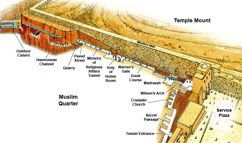
Jerusalem - Western Wall Tunnel
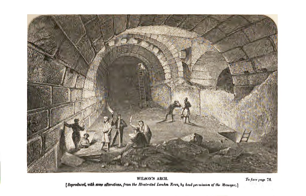
 Section of Wilson's Arch
Click on image to open a high res magnifiable image in a new tab
Wilson (1871)
- Fig. 1 - Location map,
the Great Causeway, Wilson’s Bridge from Onn et. al. (2011)
 Figure 1
Location map, the Great Causeway, Wilson’s Bridge.
Onn et. al. (2011)
- Jerusalem Wilson's Arch Area in Google Earth
 Jerusalem Wilson's Arch Area
click on image to explore this site on a new tab in Google Earth - Jerusalem Wilson's Arch Area on govmap.gov.il
 Jerusalem Wilson's Arch Area
click on image to explore this site on a new tab in govmap.gov.il
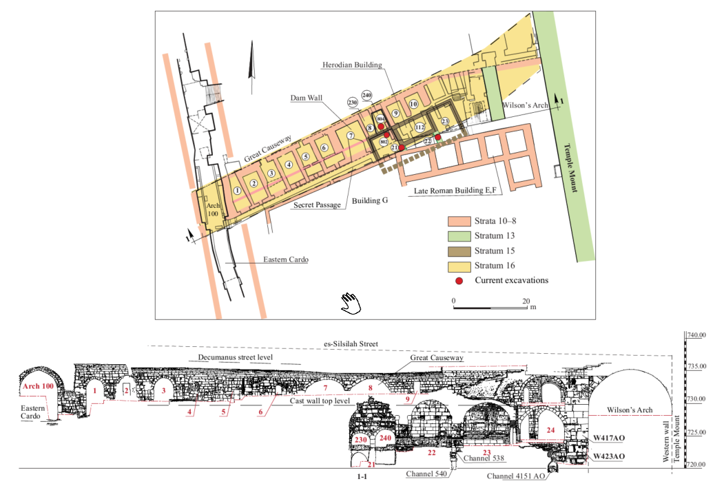
- Plan 1 Plan and Section
of excavation area west of Wilson’s Arch: the Great Causeway, the cast dam wall and the triclinium building from Weksler-Bdolah (2025)
 Plan 1
The excavation area west of Wilson’s Arch: the Great Causeway, the cast dam wall and the triclinium building, plan and section (after Weksler-Bdolah 2022: Fig. 2)
Click on image to open in a new tab
Weksler-Bdolah (2025) - Fig. 2 - General Plan
of the The Great Causeway excavations from Onn et. al. (2011)
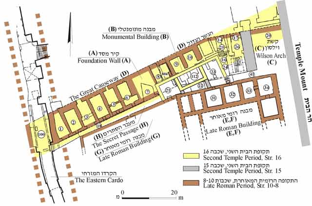 Figure 2
The Great Causeway excavations (Alexander Onn, 2007–2010), general plan.
Onn et. al. (2011) - Fig. 2 - General Plan
of the the Great Causeway excavations from Onn and Weksler-Bdolah (2016)
 Figure 2
Wilson’s Arch, the Great Causeway and the monumental building from the excavations of A. Onn, general plan.
Onn and Weksler-Bdolah (2016) - Fig. 5 - Plan of Stratum 16
in Buildings A and B from Onn et. al. (2011)
 Figure 5
Stratum 16, Buildings A and B, plan.
Onn et. al. (2011) - Fig. 13 - Plan of Strata 15
to 13 from Onn et. al. (2011)
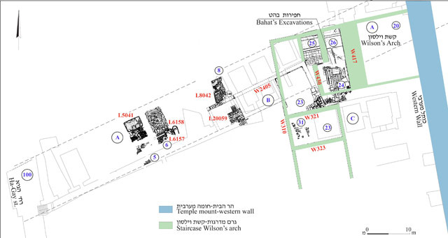 Figure 13
Strata 15–13, plan.
Onn et. al. (2011) - Fig. 22 - Plan of Strata 11-8
(Roman Period) from Onn et. al. (2011)
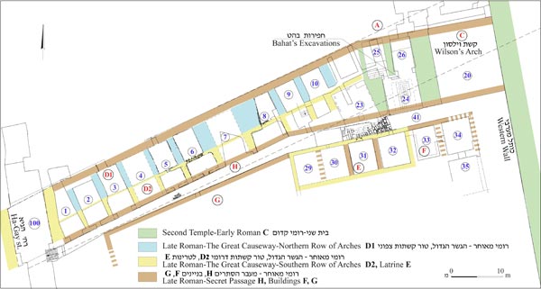 Figure 22
General plan of the Roman period, Strata 11-8 plan.
Onn et. al. (2011)
- Plan 1 Plan and Section
of excavation area west of Wilson’s Arch: the Great Causeway, the cast dam wall and the triclinium building from Weksler-Bdolah (2025)
Plan 1
The excavation area west of Wilson’s Arch: the Great Causeway, the cast dam wall and the triclinium building, plan and section (after Weksler-Bdolah 2022: Fig. 2)
Click on image to open in a new tab
Weksler-Bdolah (2025) - Fig. 2 - General Plan
of the The Great Causeway excavations from Onn et. al. (2011)
Figure 2
The Great Causeway excavations (Alexander Onn, 2007–2010), general plan.
Onn et. al. (2011) - Fig. 2 - General Plan
of the the Great Causeway excavations from Onn and Weksler-Bdolah (2016)
Figure 2
Wilson’s Arch, the Great Causeway and the monumental building from the excavations of A. Onn, general plan.
Onn and Weksler-Bdolah (2016) - Fig. 5 - Plan of Stratum 16
in Buildings A and B from Onn et. al. (2011)
Figure 5
Stratum 16, Buildings A and B, plan.
Onn et. al. (2011) - Fig. 13 - Plan of Strata 15
to 13 from Onn et. al. (2011)
Figure 13
Strata 15–13, plan.
Onn et. al. (2011) - Fig. 22 - Plan of Strata 11-8
(Roman Period) from Onn et. al. (2011)
Figure 22
General plan of the Roman period, Strata 11-8 plan.
Onn et. al. (2011)
- Route of the Western Wall
Tunnel from Wikipedia
 Route of the Western Wall Tunnel
Modified by JoeDeRose - Courtesy of the Western Wall Heritage Foundation (GFDL- תמר הירדני, באדיבות הקרן למורשת הכותל-היוצר)
GNU Free Documentation License, Version 1.2 - Wikipedia - Fig. 14 - Isometric reconstruction
of Wilson’s Arch interchange from Onn et. al. (2011)
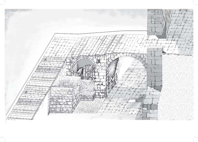 Figure 14
Wilson’s Arch interchange (Building C), isometric reconstruction
Drawing: Y. Shmidov
Onn et. al. (2011) - Fig. 24 - Isometric reconstruction
of The Great Causeway from Onn et. al. (2011)
 Figure 24
The Great Causeway, isometric reconstruction
Onn et. al. (2011)
- Fig. 3 - Section of the Great
Causeway looking north from Onn et. al. (2011)
 Figure 3
The Great Causeway, section, looking north.
Onn et. al. (2011) - Section of Wilson's Arch
from Wilson (1871)
 Section of Wilson's Arch
Click on image to open a high res magnifiable image in a new tab
Wilson (1871) - Drawing of the discovery
of Wilson's Arch from Wilson (1871)
 Drawing of the discovery of Wilson's Arch
Click on image to open a high res magnifiable image in a new tab
Wilson (1871)
- Fig. 3 - Section of the Great
Causeway looking north from Onn et. al. (2011)
Figure 3
The Great Causeway, section, looking north.
Onn et. al. (2011) - Section of Wilson's Arch
from Wilson (1871)
Section of Wilson's Arch
Click on image to open a high res magnifiable image in a new tab
Wilson (1871) - Drawing of the discovery
of Wilson's Arch from Wilson (1871)
Drawing of the discovery of Wilson's Arch
Click on image to open a high res magnifiable image in a new tab
Wilson (1871)
- Fig. 21 - Stratum 14 collapse
likely due to Fall of Jerusalem in 70 CE or possibly due to the Jerusalem Quake from Onn et. al. (2011)
 Fig. 21
Room 504, destruction collapse (L5042) inside Installation 5060, looking west.
JW: This Figure was not described in the text of Onn et al (2011) and is difficult to locate in plans but may be damage from the Stratum 14 collapse. This collapse was assigned to the fall of Jerusalem in 70 CE (Weksler-Bdolah, personal communication 28 Nov. 2023)
Onn et. al. (2011)
- Fig. 21 - Stratum 14 collapse
likely due to Fall of Jerusalem in 70 CE or possibly due to the Jerusalem Quake from Onn et. al. (2011)
Fig. 21
Room 504, destruction collapse (L5042) inside Installation 5060, looking west.
JW: This Figure was not described in the text of Onn et al (2011) and is difficult to locate in plans but may be damage from the Stratum 14 collapse. This collapse was assigned to the fall of Jerusalem in 70 CE (Weksler-Bdolah, personal communication 28 Nov. 2023)
Onn et. al. (2011)
- Fig. 2 - General Plan
of the the Great Causeway excavations from Onn and Weksler-Bdolah (2016)
Figure 2
Wilson’s Arch, the Great Causeway and the monumental building from the excavations of A. Onn, general plan.
Onn and Weksler-Bdolah (2016) - Fig. 3 - Plan of the remains
from the Roman period in the vicinity of Wilson’s Arch from Onn and Weksler-Bdolah (2016)
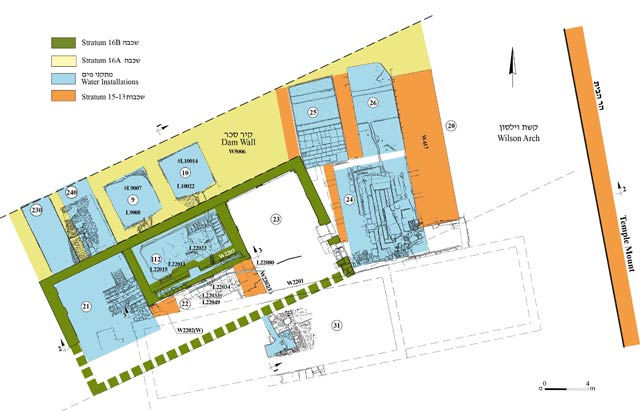 Figure 3
The remains from the Roman period in the vicinity of Wilson’s Arch, plan
Onn and Weksler-Bdolah (2016) - Fig. 4 - Section of Foundation
Wall 5006 and Monumental Building B, and the vaults of the Great Causeway above them from Onn and Weksler-Bdolah (2016)
 Figure 4
Foundation Wall 5006 and Monumental Building B, and the vaults of the Great Causeway above them—10 North (10N) and 10 South (10S), and to their south—the Secret Passage (13), looking east; section.
Onn and Weksler-Bdolah (2016) - Fig. 5 - Wilson’s Arch (20),
the monumental building (21–23) and the vaults of the Great Causeway above them from Onn and Weksler-Bdolah (2016)
 Figure 5
Wilson’s Arch (20), the monumental building (21–23) and the vaults of the Great Causeway above them, looking north; section.
Onn and Weksler-Bdolah (2016) - Fig. 6 - Room 22, Wall 2203
from Onn and Weksler-Bdolah (2016)
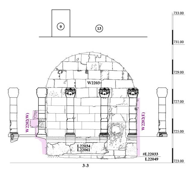 Figure 6
Room 22, Wall 2203, looking north; section.
Onn and Weksler-Bdolah (2016)
- Fig. 2 - General Plan
of the the Great Causeway excavations from Onn and Weksler-Bdolah (2016)
Figure 2
Wilson’s Arch, the Great Causeway and the monumental building from the excavations of A. Onn, general plan.
Onn and Weksler-Bdolah (2016) - Fig. 3 - Plan of the remains
from the Roman period in the vicinity of Wilson’s Arch from Onn and Weksler-Bdolah (2016)
Figure 3
The remains from the Roman period in the vicinity of Wilson’s Arch, plan
Onn and Weksler-Bdolah (2016) - Fig. 4 - Section of Foundation
Wall 5006 and Monumental Building B, and the vaults of the Great Causeway above them from Onn and Weksler-Bdolah (2016)
Figure 4
Foundation Wall 5006 and Monumental Building B, and the vaults of the Great Causeway above them—10 North (10N) and 10 South (10S), and to their south—the Secret Passage (13), looking east; section.
Onn and Weksler-Bdolah (2016) - Fig. 5 - Wilson’s Arch (20),
the monumental building (21–23) and the vaults of the Great Causeway above them from Onn and Weksler-Bdolah (2016)
Figure 5
Wilson’s Arch (20), the monumental building (21–23) and the vaults of the Great Causeway above them, looking north; section.
Onn and Weksler-Bdolah (2016) - Fig. 6 - Room 22, Wall 2203
from Onn and Weksler-Bdolah (2016)
Figure 6
Room 22, Wall 2203, looking north; section.
Onn and Weksler-Bdolah (2016)
- Fig. 1 - Location map
from Uziel et al. (2019a)
 Figure 1
Location map
Uziel et al. (2019a) - Fig. 2 - Plan
from Uziel et al. (2019a)
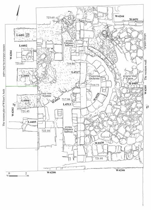 Figure 2
Plan
Uziel et al. (2019a) - Fig. 3 - Section 1-1
from Uziel et al. (2019a)
 Figure 3
Section 1-1, looking south
Uziel et al. (2019a) - Fig. 4 - Western pier of
Wilson’s Arch from Uziel et al. (2019a)
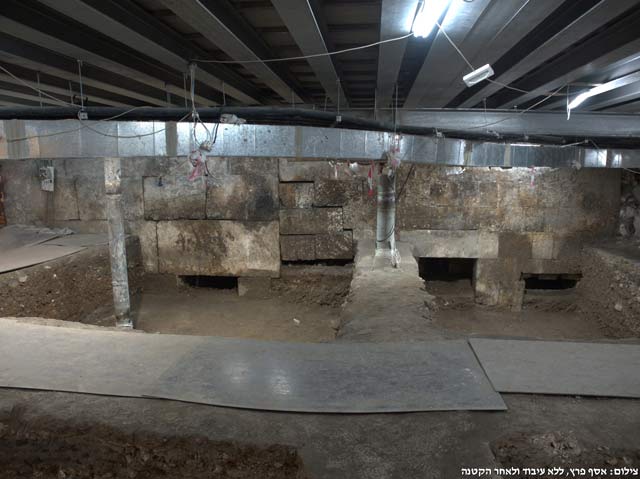 Figure 4
Western pier of Wilson’s Arch, looking west.
Uziel et al. (2019a) - Fig. 5 - western wall
from Uziel et al. (2019a)
 Figure 5
The western wall, looking east
Uziel et al. (2019a) - Fig. 6 - Theater-like structure
from Uziel et al. (2019a)
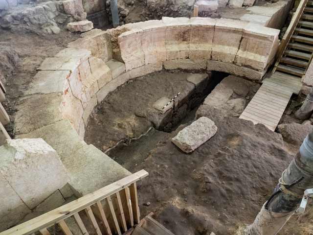 Figure 6
Theater-like structure (L4420), looking southeast
Uziel et al. (2019a) - Fig. 7 - Channel 4261
from Uziel et al. (2019a)
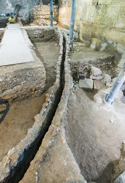 Figure 7
Channel 4261, looking northeast
Uziel et al. (2019a) - Fig. 8 - Plaster foundation
layers of Stratum I ‘Birkat al-Burāq’ reservoir from Uziel et al. (2019a)
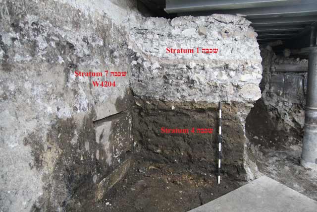 Figure 8
Plaster foundation layers of Stratum I ‘Birkat al-Burāq’ reservoir, abutting Wilson’s Arch pier (W4204) and overlying Stratum 4 accumulations, looking northwest.
Uziel et al. (2019a)
- Fig. 1 - Location map
from Uziel et al. (2019a)
Figure 1
Location map
Uziel et al. (2019a) - Fig. 2 - Plan
from Uziel et al. (2019a)
Figure 2
Plan
Uziel et al. (2019a) - Fig. 3 - Section 1-1
from Uziel et al. (2019a)
Figure 3
Section 1-1, looking south
Uziel et al. (2019a) - Fig. 4 - Western pier of
Wilson’s Arch from Uziel et al. (2019a)
Figure 4
Western pier of Wilson’s Arch, looking west.
Uziel et al. (2019a) - Fig. 5 - western wall
from Uziel et al. (2019a)
Figure 5
The western wall, looking east
Uziel et al. (2019a) - Fig. 6 - Theater-like structure
from Uziel et al. (2019a)
Figure 6
Theater-like structure (L4420), looking southeast
Uziel et al. (2019a) - Fig. 7 - Channel 4261
from Uziel et al. (2019a)
Figure 7
Channel 4261, looking northeast
Uziel et al. (2019a) - Fig. 8 - Plaster foundation
layers of Stratum I ‘Birkat al-Burāq’ reservoir from Uziel et al. (2019a)
Figure 8
Plaster foundation layers of Stratum I ‘Birkat al-Burāq’ reservoir, abutting Wilson’s Arch pier (W4204) and overlying Stratum 4 accumulations, looking northwest.
Uziel et al. (2019a)
- Fig. 1 - Location map
from Uziel et al. (2019)
 Figure 1
Map showing the area of the Temple Mount, the Great Causeway and Wilson's Arch.
Uziel et al. (2019) - Fig. 2 - Plan and Photo
of excavations from Uziel et al. (2019)
 Figure 2
Plan of the excavations, showing remains from Strata 8, 7 and 6a, b. Figure 2a:
- pink = Stratum 8
- green= Stratum 7C
- orange = Stratum 7B
- black = Stratum 6
Uziel et al. (2019) - Fig. 3 - Photo of the newly
exposed section of the Western Wall beneath Wilson's Arch from Uziel et al. (2019)
 Figure 3
View of the newly exposed section of the Western Wall beneath Wilson's Arch, looking east.
Uziel et al. (2019) - Fig. 4 - Section of the pier
of Wilson's Arch from Uziel et al. (2019)
 Figure 4
View of the pier of Wilson's Arch, looking west. Numbers refer to strata as discussed in article.
Uziel et al. (2019) - Fig. 5 - Photo of Stratum 7
drainage channel from Uziel et al. (2019)
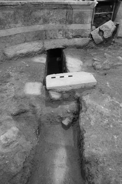 Figure 5
View of Stratum 7 drainage channel.
Uziel et al. (2019) - Fig. 9 - Section of the excavations
beneath Wilson's Arch from Uziel et al. (2019)
 Figure 9
Section of the excavations beneath Wilson's Arch, looking east. Numbers refer to strata as discussed in the article. Stratum 5B is not shown in the figure as it covered Strata 6
Uziel et al. (2019)
- Fig. 1 - Location map
from Uziel et al. (2019)
Figure 1
Map showing the area of the Temple Mount, the Great Causeway and Wilson's Arch.
Uziel et al. (2019) - Fig. 2 - Plan and Photo
of excavations from Uziel et al. (2019)
Figure 2
Plan of the excavations, showing remains from Strata 8, 7 and 6a, b. Figure 2a:
- pink = Stratum 8
- green= Stratum 7C
- orange = Stratum 7B
- black = Stratum 6
Uziel et al. (2019) - Fig. 3 - Photo of the newly
exposed section of the Western Wall beneath Wilson's Arch from Uziel et al. (2019)
Figure 3
View of the newly exposed section of the Western Wall beneath Wilson's Arch, looking east.
Uziel et al. (2019) - Fig. 4 - Section of the pier
of Wilson's Arch from Uziel et al. (2019)
Figure 4
View of the pier of Wilson's Arch, looking west. Numbers refer to strata as discussed in article.
Uziel et al. (2019) - Fig. 5 - Photo of Stratum 7
drainage channel from Uziel et al. (2019)
Figure 5
View of Stratum 7 drainage channel.
Uziel et al. (2019) - Fig. 9 - Section of the excavations
beneath Wilson's Arch from Uziel et al. (2019)
Figure 9
Section of the excavations beneath Wilson's Arch, looking east. Numbers refer to strata as discussed in the article. Stratum 5B is not shown in the figure as it covered Strata 6
Uziel et al. (2019)
- Fig. 4 - Chronological chart
of Wilson's arch excavation from Regev et al (2020)
 Fig. 4
Summarizing chronological chart of Wilson's arch excavation. Comparing the rulers and major events in the history of Jerusalem to the radiocarbon dating of the strata. The grey vertical rectangles mark the length of the historical events. The histograms represent the total probability distributions of the radiocarbon measurements of each stratum (using the 'Sum' function in OxCal).
Regev et al (2020) - Fig. 3 - Age Model of Wilson's
arch excavation from Regev et al (2020)
 Fig. 3
Multiplot of the stratigraphy-based radiocarbon model of Wilson's arch. The areas plotted in black depict the modeled posterior age of the sample, while the light gray areas depict the entire calibrated range of the measurement.
Regev et al (2020)
- Fig. 4 - Chronological chart
of Wilson's arch excavation from Regev et al (2020)
Fig. 4
Summarizing chronological chart of Wilson's arch excavation. Comparing the rulers and major events in the history of Jerusalem to the radiocarbon dating of the strata. The grey vertical rectangles mark the length of the historical events. The histograms represent the total probability distributions of the radiocarbon measurements of each stratum (using the 'Sum' function in OxCal).
Regev et al (2020) - Fig. 3 - Age Model of Wilson's
arch excavation from Regev et al (2020)
Fig. 3
Multiplot of the stratigraphy-based radiocarbon model of Wilson's arch. The areas plotted in black depict the modeled posterior age of the sample, while the light gray areas depict the entire calibrated range of the measurement.
Regev et al (2020)
- from Uziel et al. (2019a)
- Fig. 1 - Location map
from Uziel et al. (2019a)
Figure 1
Location map
Uziel et al. (2019a) - Fig. 2 - Plan
from Uziel et al. (2019a)
Figure 2
Plan
Uziel et al. (2019a) - Fig. 3 - Section 1-1
from Uziel et al. (2019a)
Figure 3
Section 1-1, looking south
Uziel et al. (2019a) - Fig. 4 - Western pier of
Wilson’s Arch from Uziel et al. (2019a)
Figure 4
Western pier of Wilson’s Arch, looking west.
Uziel et al. (2019a) - Fig. 5 - western wall
from Uziel et al. (2019a)
Figure 5
The western wall, looking east
Uziel et al. (2019a) - Fig. 6 - Theater-like structure
from Uziel et al. (2019a)
Figure 6
Theater-like structure (L4420), looking southeast
Uziel et al. (2019a) - Fig. 7 - Channel 4261
from Uziel et al. (2019a)
Figure 7
Channel 4261, looking northeast
Uziel et al. (2019a) - Fig. 8 - Plaster foundation
layers of Stratum I ‘Birkat al-Burāq’ reservoir from Uziel et al. (2019a)
Figure 8
Plaster foundation layers of Stratum I ‘Birkat al-Burāq’ reservoir, abutting Wilson’s Arch pier (W4204) and overlying Stratum 4 accumulations, looking northwest.
Uziel et al. (2019a)
- Fig. 1 - Location map
from Uziel et al. (2019a)
Figure 1
Location map
Uziel et al. (2019a) - Fig. 2 - Plan
from Uziel et al. (2019a)
Figure 2
Plan
Uziel et al. (2019a) - Fig. 3 - Section 1-1
from Uziel et al. (2019a)
Figure 3
Section 1-1, looking south
Uziel et al. (2019a) - Fig. 4 - Western pier of
Wilson’s Arch from Uziel et al. (2019a)
Figure 4
Western pier of Wilson’s Arch, looking west.
Uziel et al. (2019a) - Fig. 5 - western wall
from Uziel et al. (2019a)
Figure 5
The western wall, looking east
Uziel et al. (2019a) - Fig. 6 - Theater-like structure
from Uziel et al. (2019a)
Figure 6
Theater-like structure (L4420), looking southeast
Uziel et al. (2019a) - Fig. 7 - Channel 4261
from Uziel et al. (2019a)
Figure 7
Channel 4261, looking northeast
Uziel et al. (2019a) - Fig. 8 - Plaster foundation
layers of Stratum I ‘Birkat al-Burāq’ reservoir from Uziel et al. (2019a)
Figure 8
Plaster foundation layers of Stratum I ‘Birkat al-Burāq’ reservoir, abutting Wilson’s Arch pier (W4204) and overlying Stratum 4 accumulations, looking northwest.
Uziel et al. (2019a)
- from Uziel et al. (2019b)
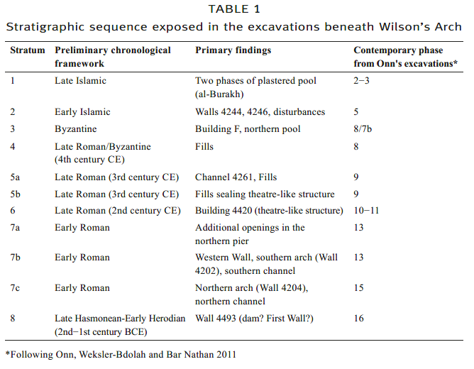 Table 1
Stratigraphic sequence exposed in the excavations beneath Wilson’s Arch
Uziel et. al. (2019b)
- from Uziel et al. (2019b)
- Fig. 1 - Location map
from Uziel et al. (2019)
Figure 1
Map showing the area of the Temple Mount, the Great Causeway and Wilson's Arch.
Uziel et al. (2019) - Fig. 2 - Plan and Photo
of excavations from Uziel et al. (2019)
Figure 2
Plan of the excavations, showing remains from Strata 8, 7 and 6a, b. Figure 2a:
- pink = Stratum 8
- green= Stratum 7C
- orange = Stratum 7B
- black = Stratum 6
Uziel et al. (2019) - Fig. 3 - Photo of the newly
exposed section of the Western Wall beneath Wilson's Arch from Uziel et al. (2019)
Figure 3
View of the newly exposed section of the Western Wall beneath Wilson's Arch, looking east.
Uziel et al. (2019) - Fig. 4 - Drawing of the pier
of Wilson's Arch from Uziel et al. (2019)
Figure 4
View of the pier of Wilson's Arch, looking west. Numbers refer to strata as discussed in article.
Uziel et al. (2019) - Fig. 5 - Photo of Stratum 7
drainage channel from Uziel et al. (2019)
Figure 5
View of Stratum 7 drainage channel.
Uziel et al. (2019) - Fig. 9 - Section of the excavations
beneath Wilson's Arch from Uziel et al. (2019)
Figure 9
Section of the excavations beneath Wilson's Arch, looking east. Numbers refer to strata as discussed in the article. Stratum 5B is not shown in the figure as it covered Strata 6
Uziel et al. (2019)
 Table 1
Stratigraphical Sequence and Main Finds in the 2007–2011 and 2018–2020 Excavations
Click on image to open in a new tab
Weksler-Bdolah (2025)
- Fig. 1 - Location map
from Uziel et al. (2019)
Figure 1
Map showing the area of the Temple Mount, the Great Causeway and Wilson's Arch.
Uziel et al. (2019) - Fig. 2 - Plan and Photo
of excavations from Uziel et al. (2019)
Figure 2
Plan of the excavations, showing remains from Strata 8, 7 and 6a, b. Figure 2a:
- pink = Stratum 8
- green= Stratum 7C
- orange = Stratum 7B
- black = Stratum 6
Uziel et al. (2019) - Fig. 3 - Photo of the newly
exposed section of the Western Wall beneath Wilson's Arch from Uziel et al. (2019)
Figure 3
View of the newly exposed section of the Western Wall beneath Wilson's Arch, looking east.
Uziel et al. (2019) - Fig. 4 - Drawing of the pier
of Wilson's Arch from Uziel et al. (2019)
Figure 4
View of the pier of Wilson's Arch, looking west. Numbers refer to strata as discussed in article.
Uziel et al. (2019) - Fig. 5 - Photo of Stratum 7
drainage channel from Uziel et al. (2019)
Figure 5
View of Stratum 7 drainage channel.
Uziel et al. (2019) - Fig. 9 - Section of the excavations
beneath Wilson's Arch from Uziel et al. (2019)
Figure 9
Section of the excavations beneath Wilson's Arch, looking east. Numbers refer to strata as discussed in the article. Stratum 5B is not shown in the figure as it covered Strata 6
Uziel et al. (2019)
The following discussion deals with two issues. The first is establishing the date of construction of Wilson’s Arch. As discussed above, several opinions regarding the dating of the arch have been posited. Though our excavation found no clear, unequivocal surface relating to the pier of the arch, much information was obtained that helps narrow the possibilities of its date. Three separate stages of construction can be discerned:
- The northern half of the pier was constructed in the first stage (Stratum 7C, see Fig. 4). During this stage the arch appears to have been 7.5 m wide, as evidenced by the western side of the pier. The northern half of the arch had one central opening (4402) with a vaulted roof.
- The width of the pier was doubled, supporting the wider arch during the second stage (Stratum 7B, see Fig. 4),. At this point, the arch was 15 m wide, and had two openings (4404 and 4405). These openings had an entranceway supported by a single lintel stone that resembled the openings like those of Robinson’s Arch.
- Two additional openings, breached into the existing pier, were created in the northern part of the pier (4401 and 4403, see Fig. 4) in the third and final stage, Niches were carved in order to insert what was probably a wooden beam that held the lintel stones in place.
- Fig. 3 - Section of the Great
Causeway looking north from Onn et. al. (2011)
Figure 3
The Great Causeway, section, looking north.
Onn et. al. (2011) - Fig. 13 - Plan of Strata 15
to 13 from Onn et. al. (2011)
Figure 13
Strata 15–13, plan.
Onn et. al. (2011) - Fig. 14 - Isometric reconstruction
of Wilson’s Arch interchange from Onn et. al. (2011)
Figure 14
Wilson’s Arch interchange (Building C), isometric reconstruction
Drawing: Y. Shmidov
Onn et. al. (2011)
| Effect | Location | Image(s) | Description |
|---|---|---|---|
|
Section of Wilson's Arch Click on image to open a high res magnifiable image in a new tab Wilson (1871)
Figure 3The Great Causeway, section, looking north. Onn et. al. (2011)
Figure 13Strata 15–13, plan. Onn et. al. (2011)
Figure 14Wilson’s Arch interchange (Building C), isometric reconstruction Drawing: Y. Shmidov Onn et. al. (2011) |
|
- Earthquake Archeological Effects chart
of Rodríguez-Pascua et al (2013: 221-224)
 Earthquake Archeological Effects (EAE)
Rodríguez-Pascua et al (2013: 221-224)
| Effect | Location | Image(s) | Description | Intensity |
|---|---|---|---|---|
|
Section of Wilson's Arch Click on image to open a high res magnifiable image in a new tab Wilson (1871)
Figure 3The Great Causeway, section, looking north. Onn et. al. (2011)
Figure 13Strata 15–13, plan. Onn et. al. (2011)
Figure 14Wilson’s Arch interchange (Building C), isometric reconstruction Drawing: Y. Shmidov Onn et. al. (2011) |
|
VIII+ |
- from Onn et. al. (2011)
- Fig. 5 - Plan of
Buildings A and B in Stratum 16 from Onn et. al. (2011)
 Figure 5
Stratum 16, Buildings A and B, plan
Onn et. al. (2011) - Fig. 6 - Isometric
reconstruction of Stratum 16 from Onn et. al. (2011)
 Figure 65
Stratum 16, isometric reconstruction
drawing Y. Shmidov
Onn et. al. (2011)
- Fig. 5 - Plan of
Buildings A and B in Stratum 16 from Onn et. al. (2011)
Figure 5
Stratum 16, Buildings A and B, plan
Onn et. al. (2011) - Fig. 6 - Isometric
reconstruction of Stratum 16 from Onn et. al. (2011)
Figure 65
Stratum 16, isometric reconstruction
drawing Y. Shmidov
Onn et. al. (2011)
Stratum 16. The Second Temple Period, the Early Construction Phase: First Century BCE
The early construction phase included a broad foundation wall (W5006; below, A; Figs. 5, 6) and a monumental public building (below, B), which consists of three halls (21, 22, 23). The northern part of Building B is integrated in Foundation Wall A. The main axis of Foundation Wall A and Building B is aligned perpendicular to the Tyropoeon Valley and extends from southwest to northeast.
Foundation Wall 5006 (Building A)
The top of W5006 was discovered in excavations currently situated 50–100 m west of the western wall of the Temple Mount, in Rooms 5 (502, 504), 6 (602, 604) and 8 (804), as well as in the Secret Passage, in front of the entrance to Room 5. It has a maximum width of c. 13 m in the area exposed so far, whereas beneath Room 804, in the area north of Hall 21 of Building A, its width was reduced to just c. 6 m. The foundation wall is built in the opus caementicium, which uses a casting of small and medium stones bonded with hard mortar (Figs. 7, 8, 9). The top of the foundation wall is uniform, at an elevation of c. 730 m above sea level. The southern side of W5006 was discovered beneath Room 804 of the Great Causeway; where it is built of courses of square, roughly hewn stones and small stones between them (Fig. 10, section 2–2). Here the foundation wall is erected on two elongated arches built of dressed stones (230, 240, Fig. 11). It seems that the construction of the vaults and casting of the foundation wall above them in this phase were done in a single construction phase; however, final conclusions would be drawn only after the excavations in Vaults 230 and 240 are completed.
The location of Foundation Wall 5006 (Building A) across the Tyropoeon Valley channel, the solid method of its construction, its great width and flat uniform top allow us to assume that it was used simultaneously as a dam and as a road. At the point where it crosses the stream channel it was probably also used as a bridge. The presumed starting point of the road borne atop Wall 5006 was in the Upper City. It most likely led to the western gate of the Temple Mount, whose location at that time was most likely several dozen meters northeast of the current Gate of the Chain.
The top of the wall was damaged by installations coated with gray hydraulic plaster, one of which has been identified as a ritual bath (L6157). These installations (L5060, L6157, L6158, L8042 in Rooms 5, 6, 8) were discovered blocked with earth and stone collapse that contained a wealth of artifacts, including fragments of pottery vessels, stone vessels and coins, dating to the end of the Second Temple period, probably when Jerusalem was destroyed in 70 CE. These finds prove that the foundation wall was built prior to the year 70 CE. The top of the foundation wall was sealed by the vault piers of the Great Causeway and it therefore predated them as well.