Jerusalem - Mount Zion
 View of Mount Zion and Dormitio Church from the Mount of Olives
Click on Image for high resolution magnifiable image
Berthold Werner - Wikipedia - Public Domain
- Fig. 1 The Old City of Jerusalem
and the King David Sepulchre complex from Zohar et al (2015)

Figure 1
The Old City of Jerusalem and the King David Sepulchre complex (outlined in orange and also in the inset). Major structures and minarets within the area include:
- Dormition Church
- the King David Sepulchre complex
- al-Nabi Da’ud minaret
- Greek-Orthodox cemetery
- Protestant cemetery
- Armenian church of the House of Caifas
- Zion Gate
- David Citadel with the al-Qal’a minaret
- Jaffa Gate
- ‘Hurva’ synagogue
- al-Omari minaret
- Church of the Holy Sepulchre
- al-Jami Omar mosque and minaret
- al-Hanaqah mosque and minaret
- al-Fakhriyya minaret
- Bab al-Silsila minaret
- al-Aqsa mosque
- al-Ghawanima minaret
- Bab al-Asbat minaret
- al-Hamra mosque and minaret
- al-Maulawiyya mosque and minaret
- Damascus Gate
- Church of the Ascension
- Church of the St Prodromos
Note the classification of minarets into three types: Mamluk, Ottoman, and Mamluk minarets that were probably renovated by the Ottomans (for further discussion see Alud and Hillenbrand 2000, 334).
Zohar et al (2015) - Fig. 3 Damage Distributions
for 1834 and 1837 CE Earthquakes from Zohar et al (2015)
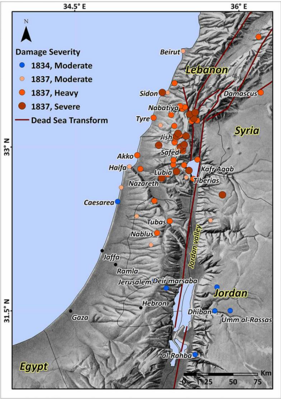 Figure 3
Damage distribution and its severity, ranging between ‘Moderate’ and ‘Severe’ (adapted from Zohar et al. 2013), of the May 1834 and January 1837 earthquakes, according to historical reports. Note that the damage that resulted from the 1837 event is more severe in northern than in central Palestine and did not spread south of the Nablus region.
Zohar et al (2015) - Fig. 10.1 Sites in Jerusalem
mentioned by Zimni-Gisler in Lichtenberger and Raja (2025)
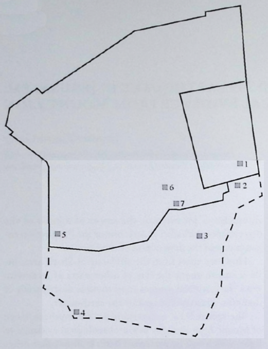 Figure 10.1
Sketch of Jerusalem mapping the sites mentioned in the text:
- Haram al-Sharif
- Ophel area
- Giv'ati parking lot
- DEI area 1
- Armenian Garden
- Jewish Quarter Excavations
- Nea Church
click on image to open in a new tab
Lichtenberger and Raja (2025)
- Fig. 1 The Old City of Jerusalem
and the King David Sepulchre complex from Zohar et al (2015)
Figure 1
The Old City of Jerusalem and the King David Sepulchre complex (outlined in orange and also in the inset). Major structures and minarets within the area include:
- Dormition Church
- the King David Sepulchre complex
- al-Nabi Da’ud minaret
- Greek-Orthodox cemetery
- Protestant cemetery
- Armenian church of the House of Caifas
- Zion Gate
- David Citadel with the al-Qal’a minaret
- Jaffa Gate
- ‘Hurva’ synagogue
- al-Omari minaret
- Church of the Holy Sepulchre
- al-Jami Omar mosque and minaret
- al-Hanaqah mosque and minaret
- al-Fakhriyya minaret
- Bab al-Silsila minaret
- al-Aqsa mosque
- al-Ghawanima minaret
- Bab al-Asbat minaret
- al-Hamra mosque and minaret
- al-Maulawiyya mosque and minaret
- Damascus Gate
- Church of the Ascension
- Church of the St Prodromos
Note the classification of minarets into three types: Mamluk, Ottoman, and Mamluk minarets that were probably renovated by the Ottomans (for further discussion see Alud and Hillenbrand 2000, 334).
Zohar et al (2015) - Fig. 3 Damage Distributions
for 1834 and 1837 CE Earthquakes from Zohar et al (2015)
Figure 3
Damage distribution and its severity, ranging between ‘Moderate’ and ‘Severe’ (adapted from Zohar et al. 2013), of the May 1834 and January 1837 earthquakes, according to historical reports. Note that the damage that resulted from the 1837 event is more severe in northern than in central Palestine and did not spread south of the Nablus region.
Zohar et al (2015) - Fig. 10.1 Sites in Jerusalem
mentioned by Zimni-Gisler in Lichtenberger and Raja (2025)
Figure 10.1
Sketch of Jerusalem mapping the sites mentioned in the text:
- Haram al-Sharif
- Ophel area
- Giv'ati parking lot
- DEI area 1
- Armenian Garden
- Jewish Quarter Excavations
- Nea Church
click on image to open in a new tab
Lichtenberger and Raja (2025)
- Mount Zion in Google Earth
 Mount Zion
click on image to explore this site on a new tab in Google Earth - Mount Zion on govmap.gov.il
 Mount Zion
click on image to explore this site on a new tab in govmap.gov.il - Fig. 10.2 Aerial overview
of DEI area 1 from Lichtenberger and Raja (2025)
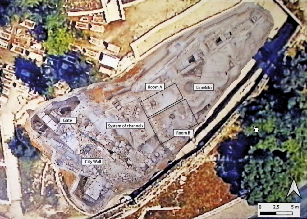 Figure 10.2
Aerial overview of DEI area 1 (BAI/DEI).
click on image to open in a new tab
Lichtenberger and Raja (2025)
- Mount Zion in Google Earth
Mount Zion
click on image to explore this site on a new tab in Google Earth - Mount Zion on govmap.gov.il
Mount Zion
click on image to explore this site on a new tab in govmap.gov.il - Fig. 10.2 Aerial overview
of DEI area 1 from Lichtenberger and Raja (2025)
Figure 10.2
Aerial overview of DEI area 1 (BAI/DEI).
click on image to open in a new tab
Lichtenberger and Raja (2025)
- Fig. 2.4 Aerial view
of Mount Zion’s southern slope marking excavation sites from Vieweger et al. (2020)
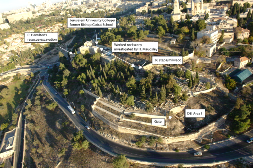 Figure 2.4
Aerial view of Mount Zion’s southern slope marking the sites described in the text
(Courtesy of Y. Zelinger, IAA)
click on image to open in a new tab
Vieweger et al. (2020) - Fig. 3.1 Aerial view
of Mount Zion’s southern slope marking excavation sites from Vieweger et al. (2020)
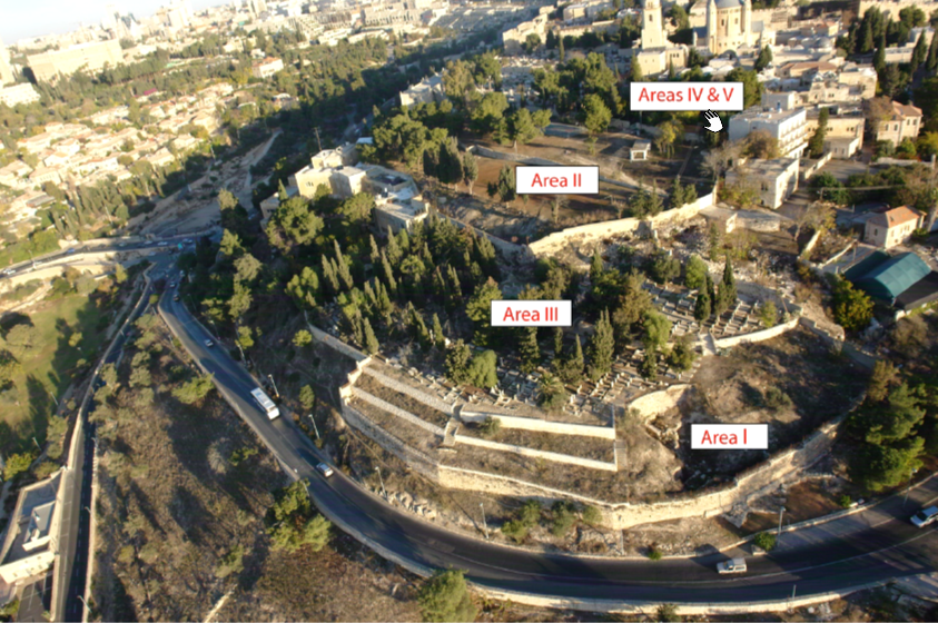 Figure 3.1
Aerial view of the southern slope of Mount Zion with the excavated areas by the DEI
(Courtesy of Y. Zelinger, IAA)
click on image to open in a new tab
Vieweger et al. (2020) - Fig. 1 Overview of
the GPIA excavation areas from Vieweger et al. (2020)
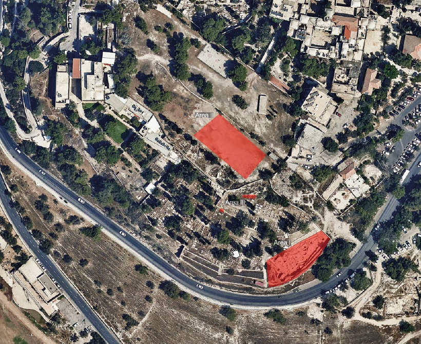 Figure 1
Jerusalem, Mount Zion. Overview of the GPIA excavation areas
click on image to open in a new tab
Vieweger et al. (2020) - Fig. 3 Aerial view
of the excavation Area I from Vieweger et al. (2020)
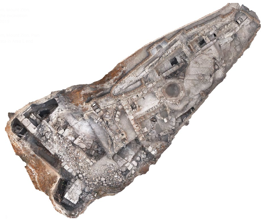 Figure 3
Jerusalem, Mount Zion. Aerial view of the excavation Area I, end of 2019
click on image to open in a new tab
Vieweger et al. (2020) - Fig. 3.3 DEI areas
I-III orthophotographs from Vieweger et al. (2020)
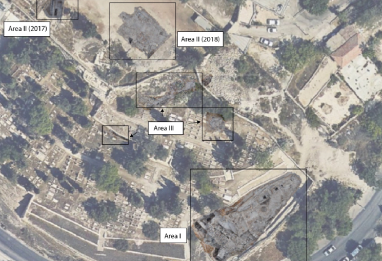 Figure 3.3
DEI areas I-III orthophotographs embedded in google earth
(Google Earth/BAI/DEI)
click on image to open in a new tab
Vieweger et al. (2020) - Fig. 4 Plan of different
strata in Area I from Vieweger et al. (2020)
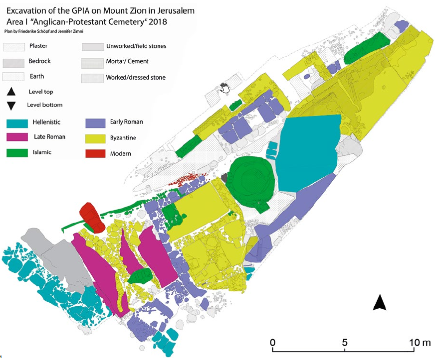 Figure 4
Jerusalem, Mount Zion. Plan of different strata in Area I, end of 2019
click on image to open in a new tab
Vieweger et al. (2020) - Fig. 6 Plan of Area I
from Vieweger et al. (2020)
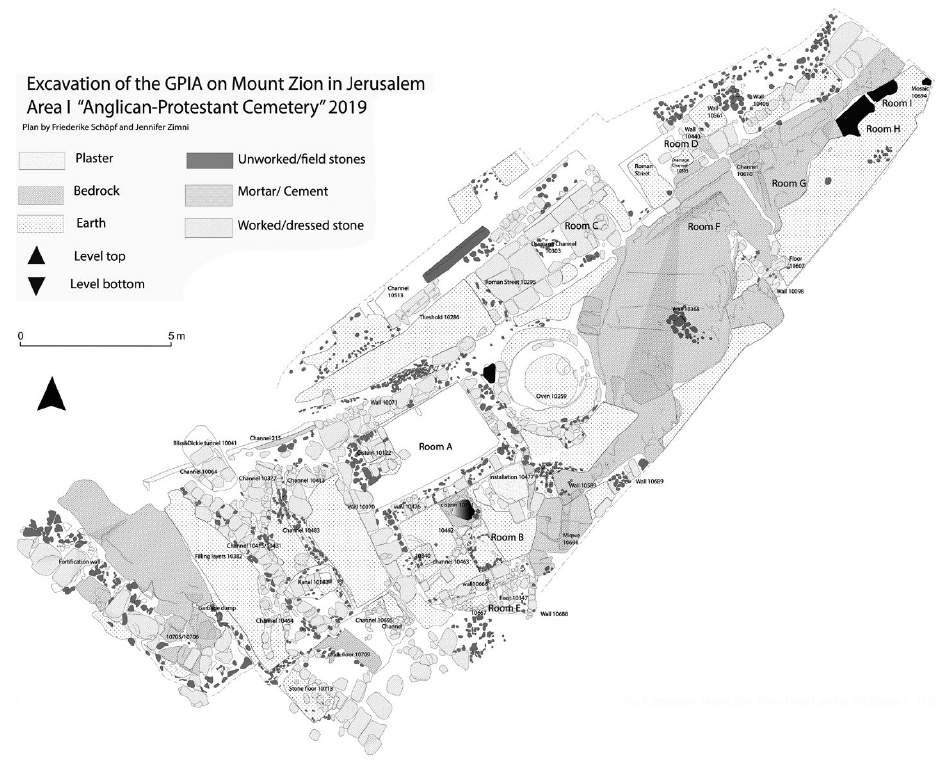 Figure 6
Jerusalem, Mount Zion. Plan of Area I, end of 2019 (scale 1 : 125)
click on image to open in a new tab
Vieweger et al. (2020) - Fig. 10.2 Aerial overview
of DEI area 1 from Lichtenberger and Raja (2025)
Figure 10.2
Aerial overview of DEI area 1 (BAI/DEI).
click on image to open in a new tab
Lichtenberger and Raja (2025) - Fig. 10.7 Warped wall
10070 within DEI area I from Lichtenberger and Raja (2025)
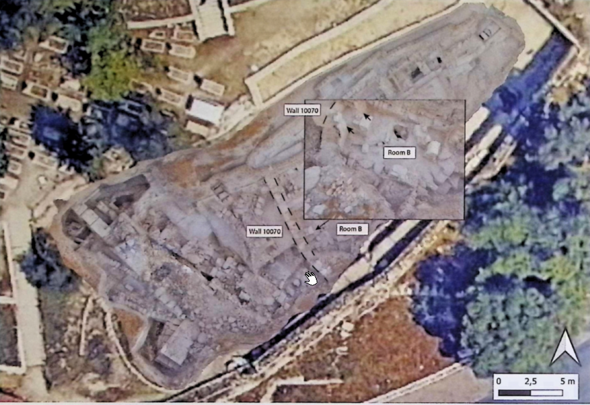 Figure 10.7
Warped wall 10070 within DEI area I (BAI/DEI).
click on image to open in a new tab
Lichtenberger and Raja (2025)
- Fig. 2.4 Aerial view
of Mount Zion’s southern slope marking excavation sites from Vieweger et al. (2020)
Figure 2.4
Aerial view of Mount Zion’s southern slope marking the sites described in the text
(Courtesy of Y. Zelinger, IAA)
click on image to open in a new tab
Vieweger et al. (2020) - Fig. 3.1 Aerial view
of Mount Zion’s southern slope marking excavation sites from Vieweger et al. (2020)
Figure 3.1
Aerial view of the southern slope of Mount Zion with the excavated areas by the DEI
(Courtesy of Y. Zelinger, IAA)
click on image to open in a new tab
Vieweger et al. (2020) - Fig. 1 Overview of
the GPIA excavation areas from Vieweger et al. (2020)
Figure 1
Jerusalem, Mount Zion. Overview of the GPIA excavation areas
click on image to open in a new tab
Vieweger et al. (2020) - Fig. 3 Aerial view
of the excavation Area I from Vieweger et al. (2020)
Figure 3
Jerusalem, Mount Zion. Aerial view of the excavation Area I, end of 2019
click on image to open in a new tab
Vieweger et al. (2020) - Fig. 3.3 DEI areas
I-III orthophotographs from Vieweger et al. (2020)
Figure 3.3
DEI areas I-III orthophotographs embedded in google earth
(Google Earth/BAI/DEI)
click on image to open in a new tab
Vieweger et al. (2020) - Fig. 4 Plan of different
strata in Area I from Vieweger et al. (2020)
Figure 4
Jerusalem, Mount Zion. Plan of different strata in Area I, end of 2019
click on image to open in a new tab
Vieweger et al. (2020) - Fig. 6 Plan of Area I
from Vieweger et al. (2020)
Figure 6
Jerusalem, Mount Zion. Plan of Area I, end of 2019 (scale 1 : 125)
click on image to open in a new tab
Vieweger et al. (2020) - Fig. 10.2 Aerial overview
of DEI area 1 from Lichtenberger and Raja (2025)
Figure 10.2
Aerial overview of DEI area 1 (BAI/DEI).
click on image to open in a new tab
Lichtenberger and Raja (2025) - Fig. 10.7 Warped wall
10070 within DEI area I from Lichtenberger and Raja (2025)
Figure 10.7
Warped wall 10070 within DEI area I (BAI/DEI).
click on image to open in a new tab
Lichtenberger and Raja (2025)
- Fig. 10.4 Orthophotograph
of room B from Lichtenberger and Raja (2025)
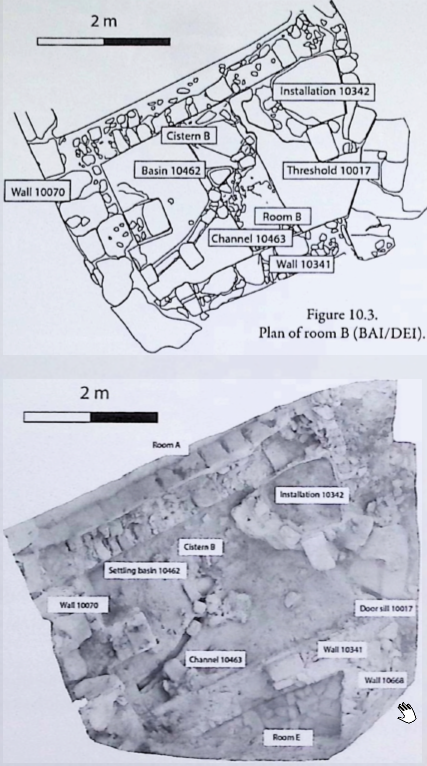 Figure 10.4
Orthophotograph of room B (BAI/DEI).
click on image to open in a new tab
Lichtenberger and Raja (2025) - Fig. 10.8 Orthophotograph
of room A from Lichtenberger and Raja (2025)
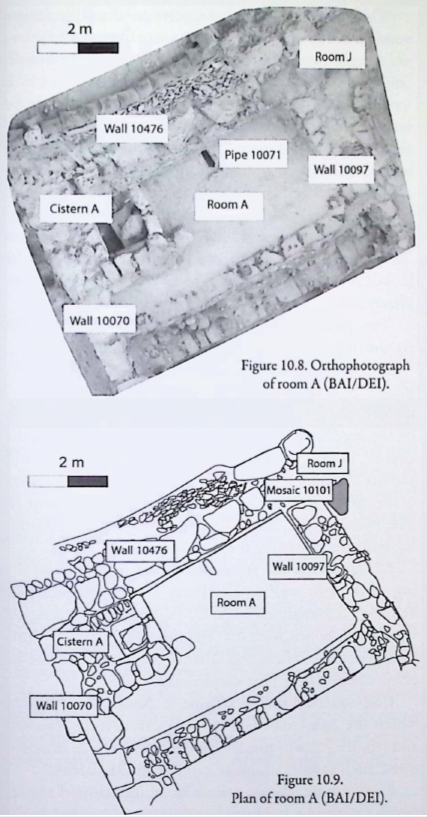 Figure 10.8
Orthophotograph of room A (BAI/DEI).
click on image to open in a new tab
Lichtenberger and Raja (2025)
- Fig. 10.4 Orthophotograph
of room B from Lichtenberger and Raja (2025)
Figure 10.4
Orthophotograph of room B (BAI/DEI).
click on image to open in a new tab
Lichtenberger and Raja (2025) - Fig. 10.8 Orthophotograph
of room A from Lichtenberger and Raja (2025)
Figure 10.8
Orthophotograph of room A (BAI/DEI).
click on image to open in a new tab
Lichtenberger and Raja (2025)
- Fig. 10.5 Destruction layer
of room B (BAI/DEI) from Lichtenberger and Raja (2025)
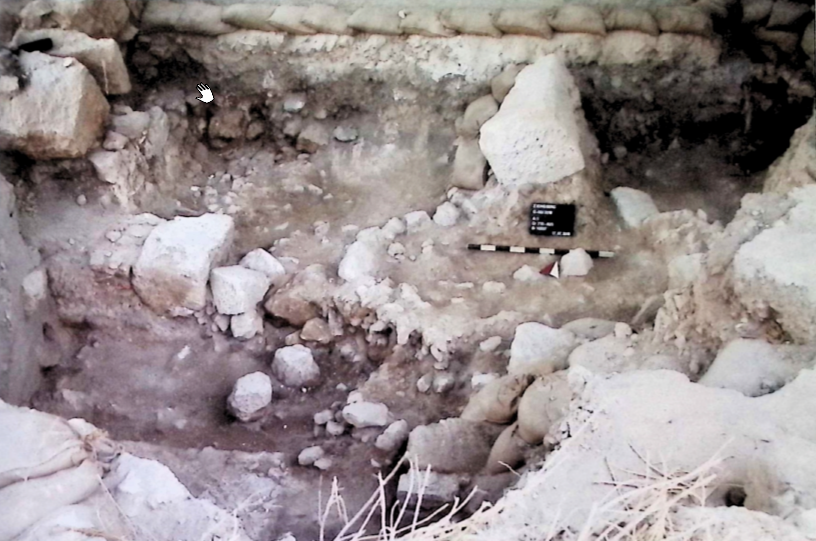 Figure 10.5
Destruction layer of room B (BAI/DEI).
click on image to open in a new tab
Lichtenberger and Raja (2025)
- Fig. 10.5 Destruction layer
of room B (BAI/DEI) from Lichtenberger and Raja (2025)
Figure 10.5
Destruction layer of room B (BAI/DEI).
click on image to open in a new tab
Lichtenberger and Raja (2025)
- Fig. 10.6 Radiocarbon
Results from Destruction Later in Room B from Lichtenberger and Raja (2025)
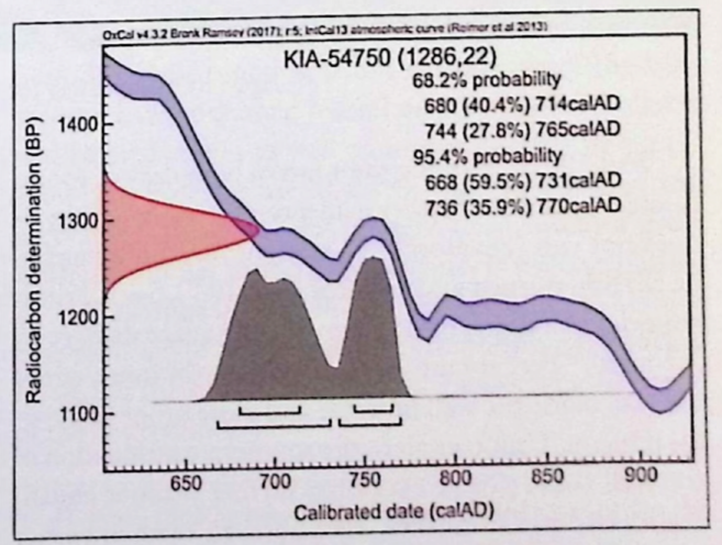 Figure 10.6
C14 dating of context 10066
BAI/DEI: carried out by AMS 14C Lab at Christian-Albrechts Univerity Kiel
click on image to open in a new tab
Lichtenberger and Raja (2025)
- Fig. 10.6 Radiocarbon
Results from Destruction Later in Room B from Lichtenberger and Raja (2025)
Figure 10.6
C14 dating of context 10066
BAI/DEI: carried out by AMS 14C Lab at Christian-Albrechts Univerity Kiel
click on image to open in a new tab
Lichtenberger and Raja (2025)
| Figure | Source | Image | Description |
|---|---|---|---|
| Figure 1 | Zohar et al (2015) |
The Old City of Jerusalem and the King David Sepulchre complex (outlined in orange and also in the inset). Major structures and minarets within the area include:
Note the classification of minarets into three types: Mamluk, Ottoman, and Mamluk minarets that were probably renovated by the Ottomans (for further discussion see Alud and Hillenbrand 2000, 334). Zohar et al (2015) |
The Old City of Jerusalem and the King David Sepulchre complex |
| Figure 2 | Zohar et al (2015) |

Photographs showing the height of the al-Nabi Da’ud minaret in various periods after mid-nineteenth century:
Zohar et al (2015) |
The Old City of Jerusalem and the King David Sepulchre complex |
| Figure 3 | Zohar et al (2015) |
Fig. 3 Damage distribution and its severity, ranging between ‘Moderate’ and ‘Severe’ (adapted from Zohar et al. 2013), of the May 1834 and January 1837 earthquakes, according to historical reports. Note that the damage that resulted from the 1837 event is more severe in northern than in central Palestine and did not spread south of the Nablus region. Zohar et al (2015) |
Damage Distributions for the 1834 and 1837 Quakes |
| Figure 4 | Zohar et al (2015) |
 Fig. 4
Views of King David’s sepulchre and visible damage (noted by red arrows):
(photographs: M.Z.) Zohar et al (2015) |
King David’s sepulchre |
| Figure 5 | Zohar et al (2015) |
 Fig. 5
Note the similarity between the two bases photographs B and C: M.Z. Zohar et al (2015) |
al-Nabi Da’ud and al-Qal’a minarets |
| Figure 6 | Zohar et al (2015) |
 Fig. 6
Pre-1834 Drawings and maps of Jerusalem. Note the high shaft of al-Nabi Da’ud minaret (magnified and also marked in black arrows) in three of the drawings, and its similarity to the al-Qal’a minaret (red arrows):
Zohar et al (2015) |
Pre-1834 Drawings and maps of Jerusalem |
| Figure 7 | Zohar et al (2015) |

al-Nabi Da’ud minaret in drawings from 1833 and similar views for comparison from mid-nineteenth century and 2013:
Zohar et al (2015) |
al-Nabi Da’ud minaret in drawings from 1833 and similar views for comparison from mid-nineteenth century and 2013 |
| Figure 8 | Zohar et al (2015) |
 Fig. 8
The complex in drawings painted in and after 1838:
In the drawings of Roberts and Bartlett (images A and B), black and red arrows denote the al-Nabi Da’ud and al-Qal’a minarets, respectively. Zohar et al (2015) |
The complex in drawings painted in and after 1838 |
| Table 1 | Zohar et al (2015) |
 Table 1
The height (in metres) of the elements in the al-Nabi Da’ud and the al-Qal’a minarets. Parts taller than 2 m were estimated according to the width of a single cut-stone block times the number of the building rows Zohar et al (2015) |
Height of elements in al-Nabi Da’ud and al-Qal’a minarets |
| Table 2 | Zohar et al (2015) |
 Table 2
Artists that have depicted the minaret of al-Nabi Da’ud Zohar et al (2015) |
Artists that have depicted the minaret of al-Nabi Da’ud |
- from Zimni (2023)
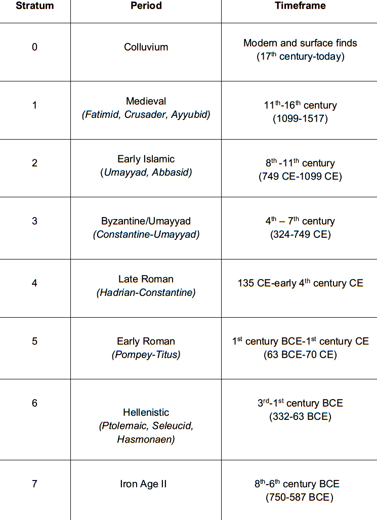 Table 4
Chronological frame of the strata and periods covered in this work
Zimni (2023)
| Effect | Location | Image | Description |
|---|---|---|---|
|
Room B on Southern Slope of Mount Zion
Figure 10.2 Aerial overview of DEI area 1 (BAI/DEI). click on image to open in a new tab Lichtenberger and Raja (2025)
Figure 10.4Orthophotograph of room B (BAI/DEI). click on image to open in a new tab Lichtenberger and Raja (2025) |
Fig. 10.5
Figure 10.5 Destruction layer of room B (BAI/DEI). click on image to open in a new tab Lichtenberger and Raja (2025) |
|
|
Room B on Southern Slope of Mount Zion
Figure 10.2 Aerial overview of DEI area 1 (BAI/DEI). click on image to open in a new tab Lichtenberger and Raja (2025) |
Fig. 10.7
Figure 10.7 Warped wall 10070 within DEI area I (BAI/DEI). click on image to open in a new tab Lichtenberger and Raja (2025) |
|
| Effect | Location | Image | Description |
|---|---|---|---|
|
al-Nabi Da'ud Minaret
The Old City of Jerusalem and the King David Sepulchre complex (outlined in orange and also in the inset). Major structures and minarets within the area include:
Note the classification of minarets into three types: Mamluk, Ottoman, and Mamluk minarets that were probably renovated by the Ottomans (for further discussion see Alud and Hillenbrand 2000, 334). Zohar et al (2015) |
Fig. 8a
 Fig. 8a
Painting by David Roberts in 1838 CE (Roberts (1842-49) that shows an apparently ruined al-Nabi Da’ud minaret (pointed to by black arrow) extracted from Zohar et al (2015) Fig. 4C
Fig. 4Views of King David’s sepulchre and visible damage (noted by red arrows):
(photographs: M.Z.) Zohar et al (2015) |
|
|
wall beside the eastern entrance facing the Muslim cemetery | Fig. 4B
Fig. 4 Views of King David’s sepulchre and visible damage (noted by red arrows):
(photographs: M.Z.) Zohar et al (2015) |
|
- Earthquake Archeological Effects chart
of Rodríguez-Pascua et al (2013: 221-224)
 Earthquake Archeological Effects (EAE)
Rodríguez-Pascua et al (2013: 221-224)
| Effect | Location | Image | Description | Intensity |
|---|---|---|---|---|
|
Room B on Southern Slope of Mount Zion
Figure 10.2 Aerial overview of DEI area 1 (BAI/DEI). click on image to open in a new tab Lichtenberger and Raja (2025)
Figure 10.4Orthophotograph of room B (BAI/DEI). click on image to open in a new tab Lichtenberger and Raja (2025) |
Fig. 10.5
Figure 10.5 Destruction layer of room B (BAI/DEI). click on image to open in a new tab Lichtenberger and Raja (2025) |
|
|
|
Room B on Southern Slope of Mount Zion
Figure 10.2 Aerial overview of DEI area 1 (BAI/DEI). click on image to open in a new tab Lichtenberger and Raja (2025) |
Fig. 10.7
Figure 10.7 Warped wall 10070 within DEI area I (BAI/DEI). click on image to open in a new tab Lichtenberger and Raja (2025) |
|
|
-
Earthquake Archeological Effects chart
of Rodríguez-Pascua et al (2013: 221-224)
Earthquake Archeological Effects (EAE)
Rodríguez-Pascua et al (2013: 221-224)
| Effect | Location | Image | Description | Intensity |
|---|---|---|---|---|
|
al-Nabi Da'ud Minaret
The Old City of Jerusalem and the King David Sepulchre complex (outlined in orange and also in the inset). Major structures and minarets within the area include:
Note the classification of minarets into three types: Mamluk, Ottoman, and Mamluk minarets that were probably renovated by the Ottomans (for further discussion see Alud and Hillenbrand 2000, 334). Zohar et al (2015) |
Fig. 8a
Fig. 8a Painting by David Roberts in 1838 CE (Roberts (1842-49) that shows an apparently ruined al-Nabi Da’ud minaret (pointed to by black arrow) extracted from Zohar et al (2015) Fig. 4C
Fig. 4Views of King David’s sepulchre and visible damage (noted by red arrows):
(photographs: M.Z.) Zohar et al (2015) |
|
|