Jerusalem - Givati Parking Lot
 The Givati Parking Lot Excavations, looking south
Ben-Ami and Tchekhanovets (2019)
- Fig. 1 - Map of ancient
Jerusalem showing Givati Parking Lot Site from Shalev et al. (2020)
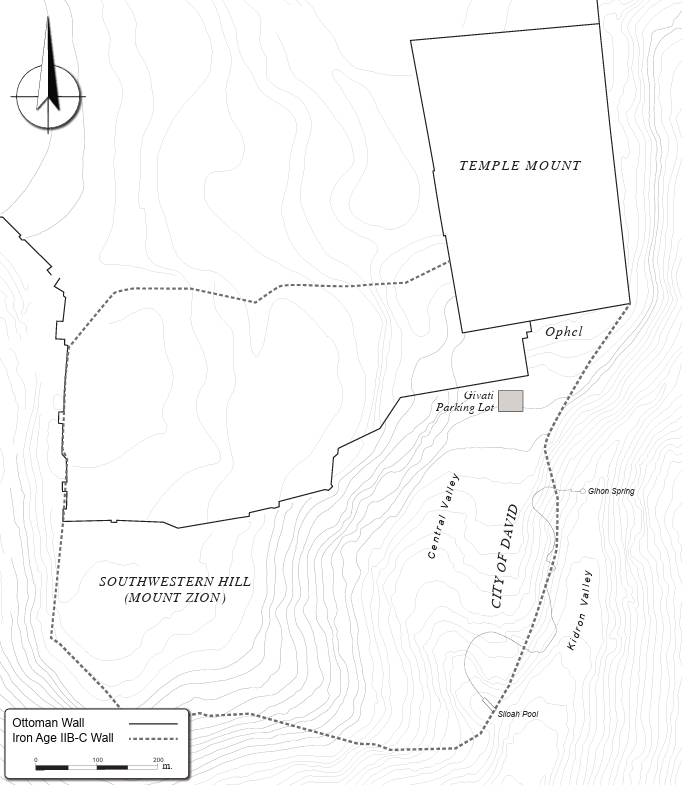 Fig. 1
Map of ancient Jerusalem marking the location of the Givati Parking Lot
Shalev et al. (2020)
- Fig. 2 - Map of Iron Age Jerusalem
from Finkelstein et. al. (2011)
 Fig. 2
Map of Jerusalem showing the possible location of the supposed mound on the Temple Mount, the City of David and the line of the Iron IIB-C city-wall.
Finkelstein et. al. (2011) - Map of Jerusalem at the
end of the First Temple period from Stern et al (1993 v. 2)
 Map of Jerusalem at the end of the First Temple period
Stern et al (1993 v. 2) - Map of Jerusalem at the
end of the Second Temple period from Stern et al (1993 v. 2)
 Map of Jerusalem at the end of the Second Temple period
Stern et al (1993 v. 2) - Map of Jerusalem in the
Roman period from Stern et al (1993 v. 2)
 Map of Jerusalem in the Roman period
Stern et al (1993 v. 2) - Map of Jerusalem in the
Byzantine period from Stern et al (1993 v. 2)
 Map of Jerusalem in the Byzantine period
Stern et al (1993 v. 2) - Map of Jerusalem in the
Early Arab period from Stern et al (1993 v. 2)
 Map of Jerusalem in the Early Arab period
Stern et al (1993 v. 2) - Map of Jerusalem in the
Crusader period from Stern et al (1993 v. 2)
 Map of Jerusalem in the Crusader period
Stern et al (1993 v. 2)
- Fig. 2 - Map of Iron Age
Jerusalem from Finkelstein et. al. (2011)
Fig. 2
Map of Jerusalem showing the possible location of the supposed mound on the Temple Mount, the City of David and the line of the Iron IIB-C city-wall.
Finkelstein et. al. (2011) - Map of Jerusalem at the
end of the First Temple period from Stern et al (1993 v. 2)
Map of Jerusalem at the end of the First Temple period
Stern et al (1993 v. 2) - Map of Jerusalem at the
end of the Second Temple period from Stern et al (1993 v. 2)
Map of Jerusalem at the end of the Second Temple period
Stern et al (1993 v. 2) - Map of Jerusalem in the
Roman period from Stern et al (1993 v. 2)
Map of Jerusalem in the Roman period
Stern et al (1993 v. 2) - Map of Jerusalem in the
Byzantine period from Stern et al (1993 v. 2)
Map of Jerusalem in the Byzantine period
Stern et al (1993 v. 2) - Map of Jerusalem in the
Early Arab period from Stern et al (1993 v. 2)
Map of Jerusalem in the Early Arab period
Stern et al (1993 v. 2) - Map of Jerusalem in the
Crusader period from Stern et al (1993 v. 2)
Map of Jerusalem in the Crusader period
Stern et al (1993 v. 2)
- Givati Site in Jerusalem in Google Earth
 Givati Site in Jerusalem
click on image to explore this site on a new tab in Google Earth - Givati Site in Jerusalem on govmap.gov.il
 Givati Site in Jerusalem
click on image to explore this site on a new tab in govmap.gov.il
- General plan of the peristyle
building from Ben-Ami and Tchekhanovets (2013)
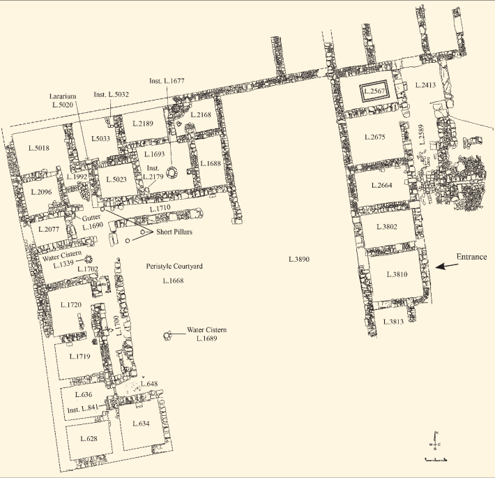 Fig. 1
General plan of the peristyle building
1980-89
Ben-Ami and Tchekhanovets (2013)
- General plan of the peristyle
building from Ben-Ami and Tchekhanovets (2013)
Fig. 1
General plan of the peristyle building
1980-89
Ben-Ami and Tchekhanovets (2013)
- Fig. 2 Aerial photo of the
Givati Parking Lot in 2018 from Shalev et al. (2020)
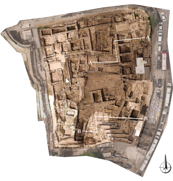 Fig. 2
Aerial photo of the Givati Parking Lot in 2018, showing all existing features at the site and the location of the sections shown in Fig. 5
(courtesy of City of David Archive, photo by Yair Izbozky).
Shalev et al. (2020) - Fig. 5a Section A-A
from Shalev et al. (2020)
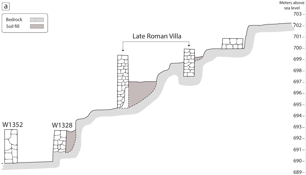 Fig. 5a
Section A-A
Shalev et al. (2020) - Fig. 5b Section B-B
from Shalev et al. (2020)
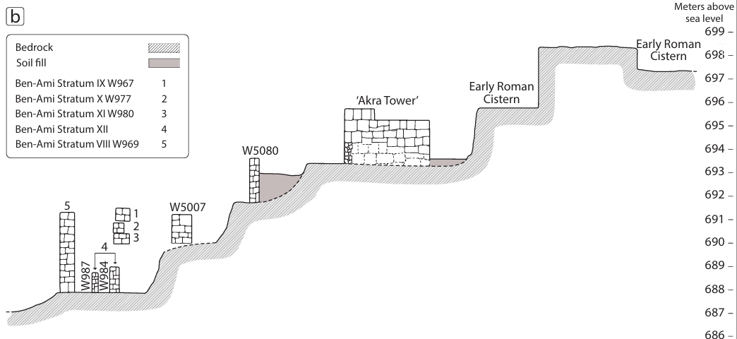 Fig. 5b
Section B-B
Shalev et al. (2020)
- Fig. 2 Aerial photo of the
Givati Parking Lot in 2018 from Shalev et al. (2020)
Fig. 2
Aerial photo of the Givati Parking Lot in 2018, showing all existing features at the site and the location of the sections shown in Fig. 5
(courtesy of City of David Archive, photo by Yair Izbozky).
Shalev et al. (2020) - Fig. 5a Section A-A
from Shalev et al. (2020)
Fig. 5a
Section A-A
Shalev et al. (2020) - Fig. 5b Section B-B
from Shalev et al. (2020)
Fig. 5b
Section B-B
Shalev et al. (2020)
- 3D reconstruction of Jerusalem
with Givati site circled in yellow from BibleWalks.com
 Jerusalem Museum model of Herod’s Jerusalem – south side – area of excavations is marked in yellow
Used with permission from BibleWalks.com
- 3D reconstruction of Jerusalem
with Givati site circled in yellow from BibleWalks.com
Jerusalem Museum model of Herod’s Jerusalem – south side – area of excavations is marked in yellow
Used with permission from BibleWalks.com
- Fig. 3 Collapse rubble in
two rooms of the peristyle building from Ben-Ami and Tchekhanovets (2013)
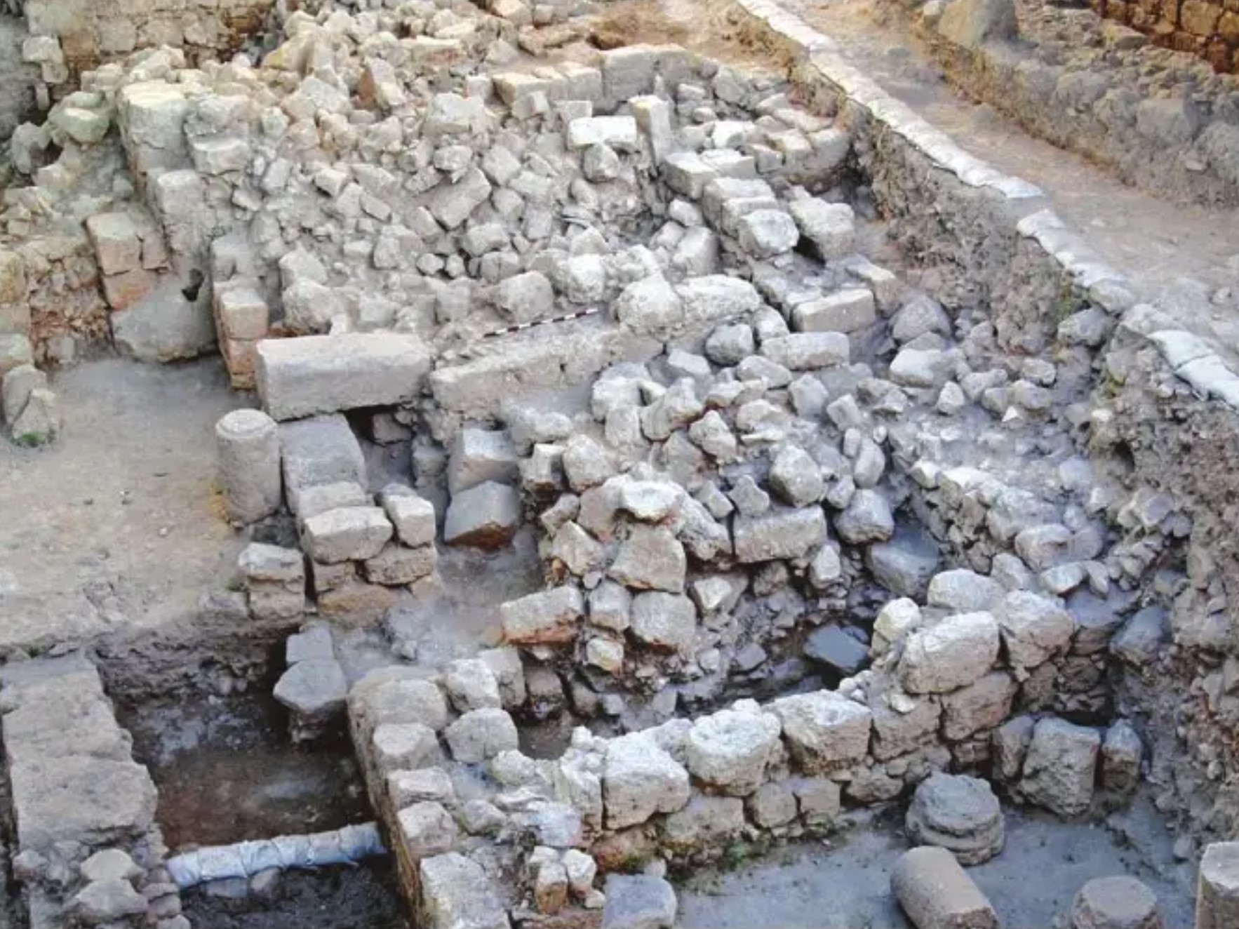 Fig. 3.
Collapse in two rooms (view to the north-west)
Ben Ami D. and Tchekhanovets Y. (2013)
| Effect | Location | Image | Description |
|---|---|---|---|
|
floor of the living area in the western wing
Fig. 1 General plan of the peristyle building 1980-89 Ben-Ami and Tchekhanovets (2013) |
Fig. 3. Collapse in two rooms (view to the north-west) JW: caption from Ben Ami and Tchekhanovets (2019) reads as follows: Rooms on the northern side of the peristyle building covered with the second floor collapse resulting from the 363 CE earthquake Ben Ami and Tchekhanovets (2013) |
|
-
Earthquake Archeological Effects chart
of Rodríguez-Pascua et al (2013: 221-224)
 Earthquake Archeological Effects (EAE)
Rodríguez-Pascua et al (2013: 221-224)
| Effect | Location | Image | Description | Intensity |
|---|---|---|---|---|
|
floor of the living area in the western wing
Fig. 1 General plan of the peristyle building 1980-89 Ben-Ami and Tchekhanovets (2013) |
Fig. 3. Collapse in two rooms (view to the north-west) Ben Ami D. and Tchekhanovets Y. (2013) |
|
|