Petra - Jabal Khubthah
APAAME
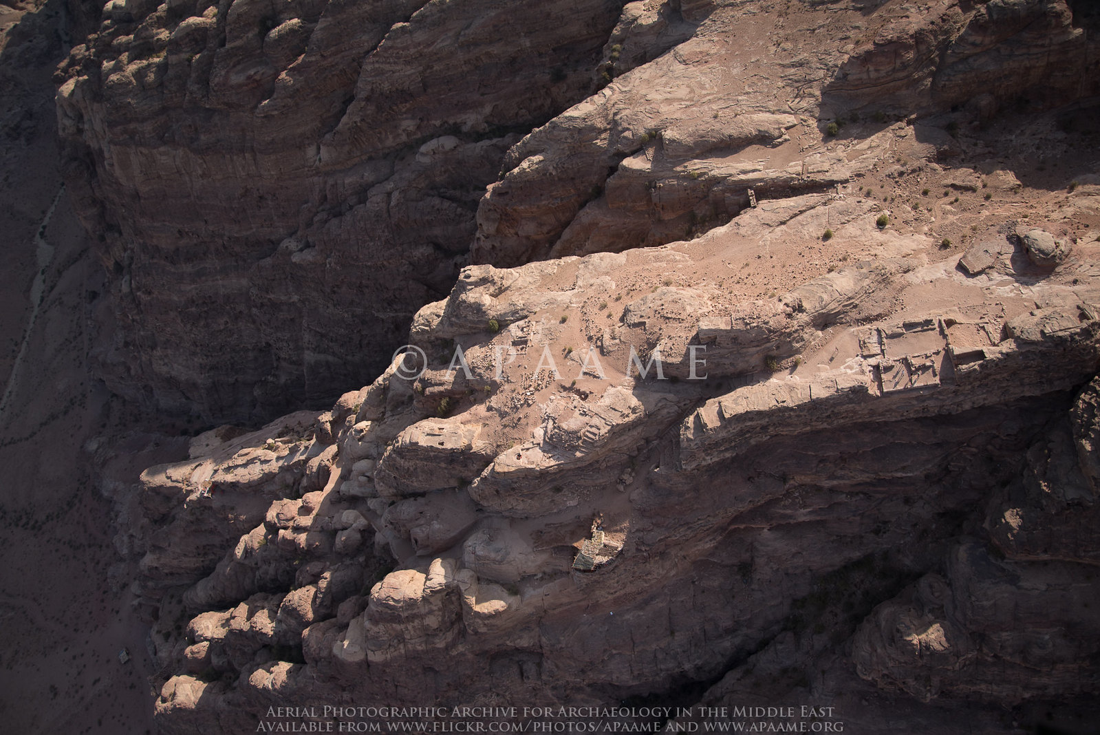
Click on Image for high resolution magnifiable image
- Reference: APAAME_20181017_MND-0190
- Photographer: Matthew Neale Dalton
- Credit: Aerial Photographic Archive for Archaeology in the Middle East
- Copyright: Creative Commons Attribution-Noncommercial-No Derivative Works
| Transliterated Name | Source | Name |
|---|---|---|
| Jabal Khubthah | Arabic | جابال كهوبتهاه |
| Jabal Umm al Amr | Arabic | جابال ومم ال امر |
| the "high place(s)" |
- Fig. 1 - Location Map from
Tholbecq et al (2014)
 Fig. 1
Localization of the Jabal Khubthah within Petra (S. Delacros).
Tholbecq et al (2014)
- Jabal Khubthah in Google Earth
 Jabal Khubthah in Google Earth - structures are at bottom left
click on image to explore this site on a new tab in Google Earth - Fig. 16 - 3D View of the
Jabal Khubthah massif from Tholbecq et al (2018)
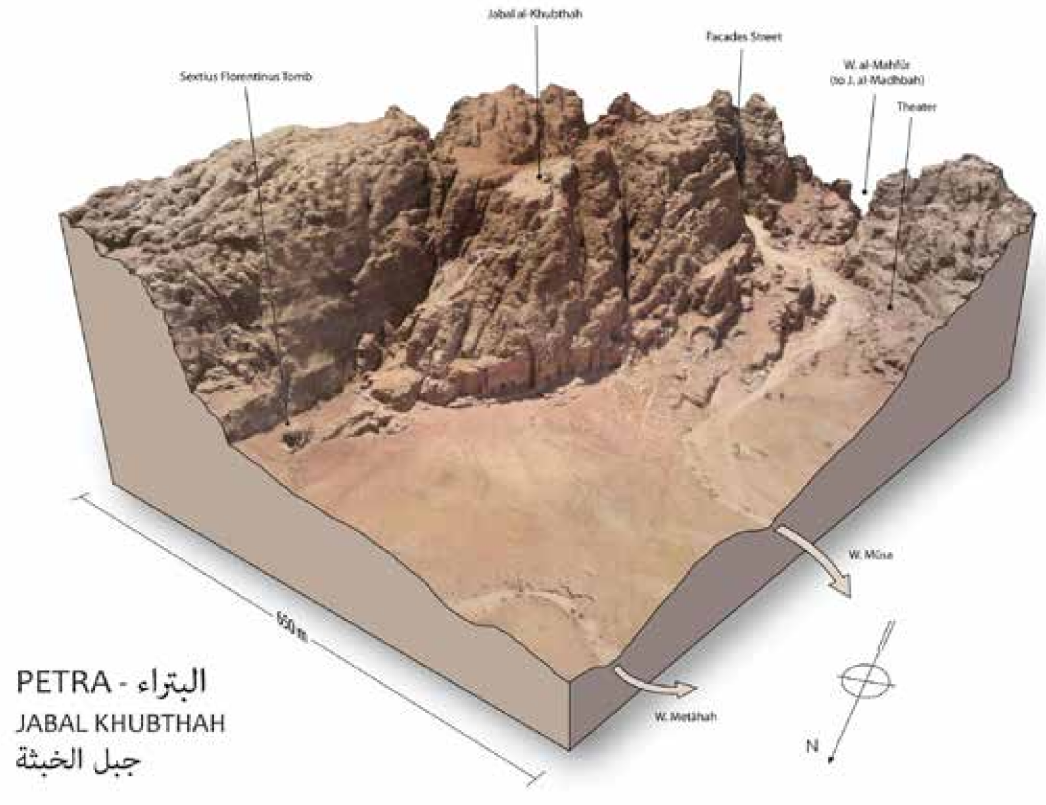 Fig. 16
3D Model of the Jabal Khubthah massif, seen from the northwest
(Th. Fournet, MAFP/Ifpo 2018)
Tholbecq et al (2019)
- Plan of Jabal Khubthah
from Tholbecq et al (2019)
 Plan of Jabal Khubthah
Tholbecq et al (2019) - Fig. 17 - Plan of
Jabal Khubthah summit plateau from Tholbecq et al (2018)
 Fig. 17
Plan of the Jabal Khubthah summit plateau
(Th. Fournet, MAFP/Ifpo 2018 on a topographic base map of S. Delcros/N. Paridaens)
Tholbecq et al (2019) - Fig. 25 - Plan of
Jabal Khubthah highlighting structures that may belong to a first occupation of the sector from Tholbecq et al (2018)
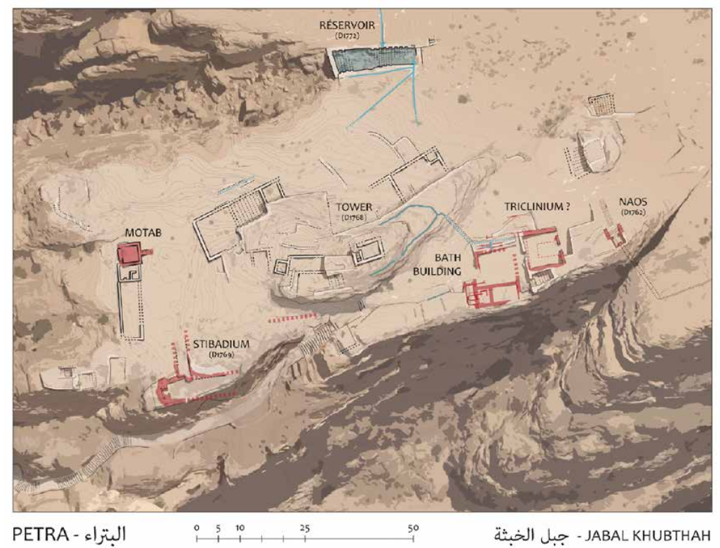 Fig. 25
Plan Jabal Khubthah summit plateau highlighting structures that may belong to a first occupation of the sector
(Th. Fournet, MAFP/Ifpo 2018 on a topographic base map of S. Delcros/N. Paridaens)
Tholbecq et al (2019)
- Plan of Jabal Khubthah
from Tholbecq et al (2019)
Plan of Jabal Khubthah
Tholbecq et al (2019) - Fig. 17 - Plan of
Jabal Khubthah summit plateau from Tholbecq et al (2018)
Fig. 17
Plan of the Jabal Khubthah summit plateau
(Th. Fournet, MAFP/Ifpo 2018 on a topographic base map of S. Delcros/N. Paridaens)
Tholbecq et al (2019) - Fig. 25 - Plan of
Jabal Khubthah highlighting structures that may belong to a first occupation of the sector from Tholbecq et al (2018)
Fig. 25
Plan Jabal Khubthah summit plateau highlighting structures that may belong to a first occupation of the sector
(Th. Fournet, MAFP/Ifpo 2018 on a topographic base map of S. Delcros/N. Paridaens)
Tholbecq et al (2019)
- Fig. 3 - Orthophoto of
Sector 6000 from Tholbecq et al (2019)
 Fig. 3
The ortho-photography of structure excavated in Sector 6000
By N. Paridaens
Tholbecq et al (2019)
- Fig. 3 - Orthophoto of
Sector 6000 from Tholbecq et al (2019)
Fig. 3
The ortho-photography of structure excavated in Sector 6000
By N. Paridaens
Tholbecq et al (2019)
- Fig. 2 - Plan of
Jabal Khubthah bath complex from Tholbecq et al (2018)
 Fig. 2
Plan of the Jabal Khubthah bath complex at the end of the 2017 campaign
(MAFP/Ifpo - Th. Fournet 2018, on a topographic base map of S. Delcros/N. Paridaens)
Tholbecq et al (2019) - Fig. 18 - Plan of
Jabal Khubthah bath complex showing restoration work locations from Tholbecq et al (2018)
 Fig. 18
Plan of Jabal Khubthah bath complex at the end of the 2017 season showing restoration work locations
(Th. Fournet, MAFP/Ifpo 2018 on a topographic base map of S. Delcros/N. Paridaens)
Tholbecq et al (2019)
- Fig. 2 - Plan of
Jabal Khubthah bath complex from Tholbecq et al (2018)
Fig. 2
Plan of the Jabal Khubthah bath complex at the end of the 2017 campaign
(MAFP/Ifpo - Th. Fournet 2018, on a topographic base map of S. Delcros/N. Paridaens)
Tholbecq et al (2019) - Fig. 18 - Plan of
Jabal Khubthah bath complex showing restoration work locations from Tholbecq et al (2018)
Fig. 18
Plan of Jabal Khubthah bath complex at the end of the 2017 season showing restoration work locations
(Th. Fournet, MAFP/Ifpo 2018 on a topographic base map of S. Delcros/N. Paridaens)
Tholbecq et al (2019)
| Effect | Location | Image(s) | Description |
|---|---|---|---|
| Collapsed walls inferred from rebuilding evidence | East complex (Sector 6000 aka Secteur 6)
Plan of Jabal Khubthah
Tholbecq et al (2019)
Fig. 3The ortho-photography of structure excavated in Sector 6000 By N. Paridaens Tholbecq et al (2019) |
|
| Effect | Location | Image(s) | Description |
|---|---|---|---|
| Collapsed arches and Stone Tumble suggesting Wall Collapse | East complex (Sector 6000 aka Secteur 6) - locus 6004
Plan of Jabal Khubthah
Tholbecq et al (2019)
Fig. 3The ortho-photography of structure excavated in Sector 6000 By N. Paridaens Tholbecq et al (2019) |
 Figure 15
The main stone tumble, locus 6004. View from SE. By N. Paridaens Tholbecq et al (2019) |
|
| Collapsed arches | East complex (Sector 6000 aka Secteur 6) - locus 6004
Plan of Jabal Khubthah
Tholbecq et al (2019)
Fig. 3The ortho-photography of structure excavated in Sector 6000 By N. Paridaens Tholbecq et al (2019) |
 Figure 11
Remains of both arches as collapsed on pavement 6011. Walls 6000/6001 and superstructure 6027 on the left side. View from the NW. By Z.T. Fiema Tholbecq et al (2019) |
|
- Earthquake Archeological Effects chart
of Rodríguez-Pascua et al (2013: 221-224)
 Earthquake Archeological Effects (EAE)
Rodríguez-Pascua et al (2013: 221-224)
| Effect | Location | Image(s) | Description | Intensity |
|---|---|---|---|---|
| Collapsed walls inferred from rebuilding evidence | East complex (Sector 6000 aka Secteur 6)
Plan of Jabal Khubthah
Tholbecq et al (2019)
Fig. 3The ortho-photography of structure excavated in Sector 6000 By N. Paridaens Tholbecq et al (2019) |
|
VIII + |
- Earthquake Archeological Effects chart
of Rodríguez-Pascua et al (2013: 221-224)
Earthquake Archeological Effects (EAE)
Rodríguez-Pascua et al (2013: 221-224)
| Effect | Location | Image(s) | Description | Intensity |
|---|---|---|---|---|
| Collapsed arches Stone Tumble suggesting Wall Collapse |
East complex (Sector 6000 aka Secteur 6) - locus 6004
Plan of Jabal Khubthah
Tholbecq et al (2019)
Fig. 3The ortho-photography of structure excavated in Sector 6000 By N. Paridaens Tholbecq et al (2019) |
Figure 15 The main stone tumble, locus 6004. View from SE. By N. Paridaens Tholbecq et al (2019) |
|
VI+ VIII + |
| Collapsed arches | East complex (Sector 6000 aka Secteur 6) - locus 6004
Plan of Jabal Khubthah
Tholbecq et al (2019)
Fig. 3The ortho-photography of structure excavated in Sector 6000 By N. Paridaens Tholbecq et al (2019) |
Figure 11 Remains of both arches as collapsed on pavement 6011. Walls 6000/6001 and superstructure 6027 on the left side. View from the NW. By Z.T. Fiema Tholbecq et al (2019) |
|
VI+ |