Ein Rahel
 Ein Rahel
click on image to explore this site on a new tab in govmap.gov.il
| Transliterated Name | Source | Name |
|---|---|---|
| Ein Rahel | Hebrew | |
| Mezad 'En Rahel | Hebrew |
- Fig. 1 - Map of the main
Hellenistic, Roman, and Byzantine sites in the Negev Hills from Stern et. al. (1993 v.3)
 Map of the main Hellenistic, Roman, and Byzantine sites in the Negev Hills.
Stern et. al. (1993 v.3)
- Fig. 1 - Map of the main
Hellenistic, Roman, and Byzantine sites in the Negev Hills from Stern et. al. (1993 v.3)
Map of the main Hellenistic, Roman, and Byzantine sites in the Negev Hills.
Stern et. al. (1993 v.3)
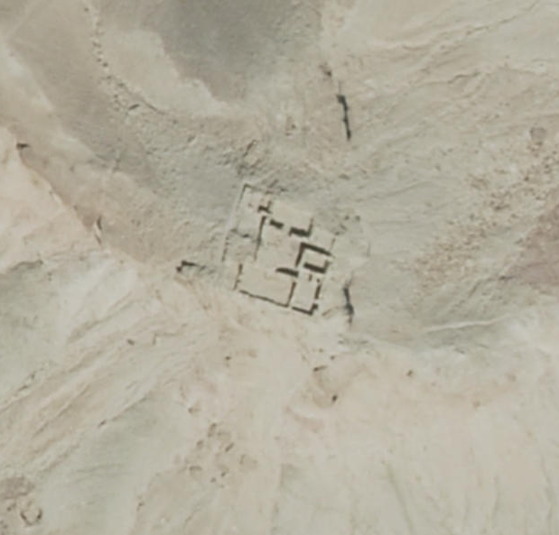
- Ein Rahel in Google Earth
 Ein Rahel
click on image to explore this site on a new tab in Google Earth - Ein Rahel on govmap.gov.il
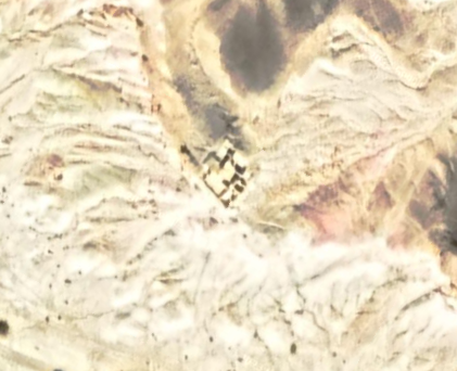
Ein Rahel
click on image to explore this site on a new tab in govmap.gov.il
- Fig. 5 - Plan of the Fort
with marked types of deformations from Korzhenkov and Erickson-Gini (2003)
 Figure 5
Ein Rahel
Plan of the fort with marked types of deformations.
Following Shamir (1999)
Korzhenkov and Erickson-Gini (2003) - Plan 1 - Plan of the Fort
from Shamir (1999)
 Plan 1
Plan of the fort at 'En Rahel
Shamir (1999)
- Fig. 5 - Plan of the Fort
with marked types of deformations from Korzhenkov and Erickson-Gini (2003)
Figure 5
Ein Rahel
Plan of the fort with marked types of deformations.
Following Shamir (1999)
Korzhenkov and Erickson-Gini (2003) - Plan 1 - Plan of the Fort
from Shamir (1999)
Plan 1
Plan of the fort at 'En Rahel
Shamir (1999)
| Seismic Effect | Plan | Figure(s) | Comments |
|---|---|---|---|
| Tilted Walls | Rooms 9, 11, 12, and 13
Figure 5 Ein Rahel Plan of the fort with marked types of deformations. Following Shamir (1999) Korzhenkov and Erickson-Gini (2003) |
8
 Figure 8
Ein Rahel Eastward tilt of eastern external wall. Strike azimuth of the wall is 16° Korzhenkov and Erickson-Gini (2003) |
Earthquake events that have occurred in other parts of the world have produced a large number of structural elements that were found to be preferentially inclined toward the epicenter. However, in some cases the inclination was in the opposing direction. Similar destruction features were found in the ancient fort at Ein Rahel where preferentially inclined walls were observed (see Fig. 5 - Plan).- Korzhenkov and Erickson-Gini (2003) |
| Oriented collapse of door lintels Eastward in Room 10 Southward in Room 20 |
Rooms 10 and 20
Figure 5 Ein Rahel Plan of the fort with marked types of deformations. Following Shamir (1999) Korzhenkov and Erickson-Gini (2003) |
9a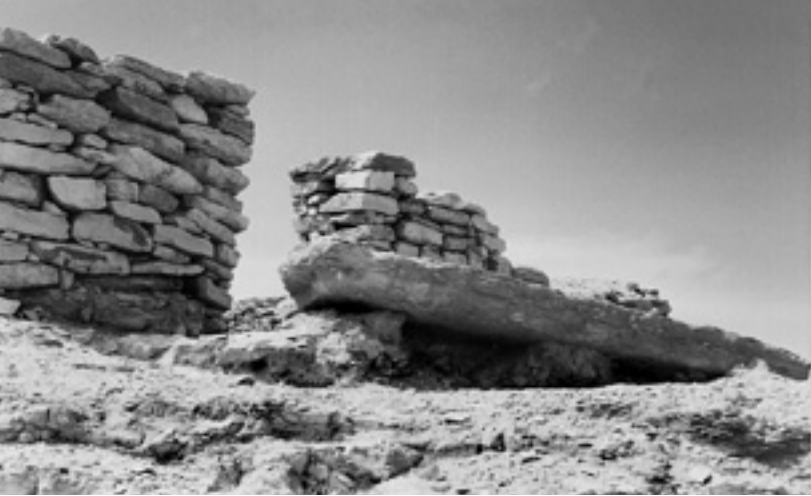 Figure 9a
Ein Rahel Oriented collapse of door lintel for NS- trending wall (strike azimuth is 16°–18°) Korzhenkov and Erickson-Gini (2003) 9b 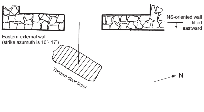 Figure 9a
Ein Rahel Schematic picture of Oriented collapse of door lintel Korzhenkov and Erickson-Gini (2003) 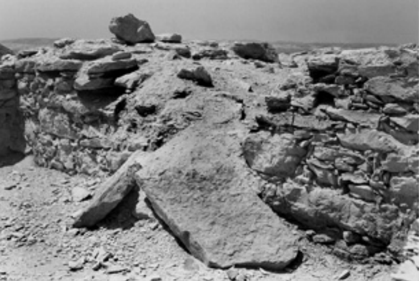 Figure 10a
Ein Rahel Southward collapse of door lintel of EW-oriented wall. Korzhenkov and Erickson-Gini (2003)  Figure 10b
Ein Rahel Schematic picture of Southward collapse of door lintel of EW-oriented wall. Korzhenkov and Erickson-Gini (2003) |
Collapsed door lintels found in the ruins of the Ein Rahel fort exhibited an oriented collapse. The seismic wave approaching the lintel perpendicular to its orientation caused an oriented collapse which can be recognized by a significant shift of the collapsed lintel on the ground in relation to its original position (Fig.9. 10). Thus the lintel above the entrance to Room 10 (see Fig.5) was thrown eastwards (Fig.9). The door lintel located between Rooms 20 and 9 was thrown southwards (Fig.10) and was broke upon impact. These observations would indicate that the propagation of the seismic waves causing the destruction was from the SE.- Korzhenkov and Erickson-Gini (2003) |
| Collapsed Walls | Upper floor
Figure 5 Ein Rahel Plan of the fort with marked types of deformations. Following Shamir (1999) Korzhenkov and Erickson-Gini (2003) |
Throughout the fort two occupational strata were observed, the earlier from the 3rd to late 2nd cent. B.C. and the later from the 1st cent. to early 2nd cent. A.D. In the surrounding casemate rooms the latest occupational phase (dating to the early 2nd cent. A.D.) was sealed by the collapse of the upper floor of the fort.- Korzhenkov and Erickson-Gini (2003) |
|
| Roof and ceiling collapse | Upper (roof) and Lower (ceiling) floors
Figure 5 Ein Rahel Plan of the fort with marked types of deformations. Following Shamir (1999) Korzhenkov and Erickson-Gini (2003) |
Throughout the fort two occupational strata were observed, the earlier from the 3rd to late 2nd cent. B.C. and the later from the 1st cent. to early 2nd cent. A.D. In the surrounding casemate rooms the latest occupational phase (dating to the early 2nd cent. A.D.) was sealed by the collapse of the upper floor of the fort. Sections excavated in these rooms revealed clear collapse of the ceiling of the lower floor and the upper floor debris sealed by the upper floor roof. The ceiling and roof of the structure were made from woven organic matting and mud and were supported by wooden beams.- Korzhenkov and Erickson-Gini (2003) |
- Modified by JW from Fig. 5 of Korzhenkov and Erickson-Gini (2003)
 Deformation Map
Modified by JW from Fig. 5 of Korzhenkov and Erickson-Gini (2003)
- Fig. 5 - Plan of the Fort
with marked types of deformations from Korzhenkov and Erickson-Gini (2003)
Figure 5
Ein Rahel
Plan of the fort with marked types of deformations.
Following Shamir (1999)
Korzhenkov and Erickson-Gini (2003) - Fig. 8 - Eastward tilt of eastern external wall
from Korzhenkov and Erickson-Gini (2003)
Figure 8
Ein Rahel
Eastward tilt of eastern external wall. Strike azimuth of the wall is 16°
Korzhenkov and Erickson-Gini (2003) - Fig. 9 - Oriented collapse of door lintel
from N-S wall from Korzhenkov and Erickson-Gini (2003)
 Figure 9
Ein Rahel
- Oriented collapse of door lintel for NS trending wall (strike azimuth is 16°–18°)
- Schematic picture
Korzhenkov and Erickson-Gini (2003) - Fig. 10 - Oriented collapse of door lintel
from E-W wall from Korzhenkov and Erickson-Gini (2003)
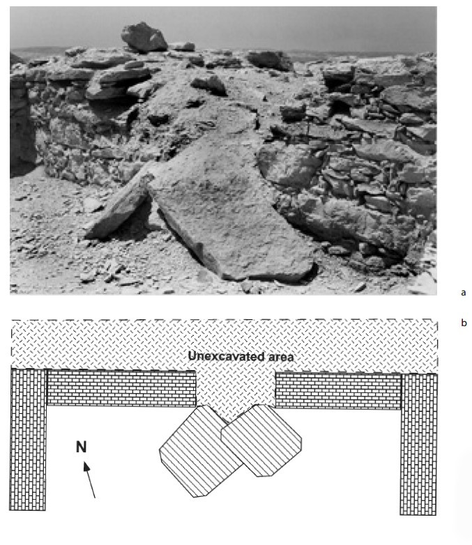 Figure 10
Ein Rahel
a Southward collapse of door lintel of EW oriented wall
b Schematic picture
Korzhenkov and Erickson-Gini (2003)
Studies of destruction in Ein Rahel fort also reveal a systematic nature of dislocations (see Fig.5):
- NS-trending walls revealed tilt (see Fig. 8) and collapse toward east, whereas perpendicular trending walls tilted and failed down without a noticeable systematic pattern. These observations indicate that the seismic shock arrived approximately along the east-west axis, most probably from the east.
- The door lintel on the N-S trending wall was thrown eastward (see Fig. 9), but the lintel on the E-W trending wall was thrown southward (see Fig. 10). This fact indicates that the propagation of the seismic energy was along the SE-NW axis, making it likely that the seismic waves came from the SE direction.
-
Earthquake Archeological Effects chart
of Rodríguez-Pascua et al (2013: 221-224)
 Earthquake Archeological Effects (EAE)
Rodríguez-Pascua et al (2013: 221-224)
| Seismic Effect | Plan | Figure(s) | Comments | Intensity |
|---|---|---|---|---|
| Tilted Walls | Rooms 9, 11, 12, and 13
Figure 5 Ein Rahel Plan of the fort with marked types of deformations. Following Shamir (1999) Korzhenkov and Erickson-Gini (2003) |
8
Figure 8 Ein Rahel Eastward tilt of eastern external wall. Strike azimuth of the wall is 16° Korzhenkov and Erickson-Gini (2003) |
Earthquake events that have occurred in other parts of the world have produced a large number of structural elements that were found to be preferentially inclined toward the epicenter. However, in some cases the inclination was in the opposing direction. Similar destruction features were found in the ancient fort at Ein Rahel where preferentially inclined walls were observed (see Fig. 5 - Plan).- Korzhenkov and Erickson-Gini (2003) |
VI + |
| Oriented collapse of door lintels - Collapsed Walls Eastward in Room 10 Southward in Room 20 |
Rooms 10 and 20
Figure 5 Ein Rahel Plan of the fort with marked types of deformations. Following Shamir (1999) Korzhenkov and Erickson-Gini (2003) |
9a
Figure 9a Ein Rahel Oriented collapse of door lintel for NS- trending wall (strike azimuth is 16°–18°) Korzhenkov and Erickson-Gini (2003) 9b
Figure 9aEin Rahel Schematic picture of Oriented collapse of door lintel Korzhenkov and Erickson-Gini (2003)
Figure 10aEin Rahel Southward collapse of door lintel of EW-oriented wall. Korzhenkov and Erickson-Gini (2003)
Figure 10bEin Rahel Schematic picture of Southward collapse of door lintel of EW-oriented wall. Korzhenkov and Erickson-Gini (2003) |
Collapsed door lintels found in the ruins of the Ein Rahel fort exhibited an oriented collapse. The seismic wave approaching the lintel perpendicular to its orientation caused an oriented collapse which can be recognized by a significant shift of the collapsed lintel on the ground in relation to its original position (Fig.9. 10). Thus the lintel above the entrance to Room 10 (see Fig.5) was thrown eastwards (Fig.9). The door lintel located between Rooms 20 and 9 was thrown southwards (Fig.10) and was broke upon impact. These observations would indicate that the propagation of the seismic waves causing the destruction was from the SE.- Korzhenkov and Erickson-Gini (2003) |
VIII + |
| Collapsed Walls | Upper floor
Figure 5 Ein Rahel Plan of the fort with marked types of deformations. Following Shamir (1999) Korzhenkov and Erickson-Gini (2003) |
Throughout the fort two occupational strata were observed, the earlier from the 3rd to late 2nd cent. B.C. and the later from the 1st cent. to early 2nd cent. A.D. In the surrounding casemate rooms the latest occupational phase (dating to the early 2nd cent. A.D.) was sealed by the collapse of the upper floor of the fort.- Korzhenkov and Erickson-Gini (2003) |
VIII + | |
| Roof and ceiling collapse - Displaced Walls | Upper (roof) and Lower (ceiling) floors
Figure 5 Ein Rahel Plan of the fort with marked types of deformations. Following Shamir (1999) Korzhenkov and Erickson-Gini (2003) |
Throughout the fort two occupational strata were observed, the earlier from the 3rd to late 2nd cent. B.C. and the later from the 1st cent. to early 2nd cent. A.D. In the surrounding casemate rooms the latest occupational phase (dating to the early 2nd cent. A.D.) was sealed by the collapse of the upper floor of the fort. Sections excavated in these rooms revealed clear collapse of the ceiling of the lower floor and the upper floor debris sealed by the upper floor roof. The ceiling and roof of the structure were made from woven organic matting and mud and were supported by wooden beams.- Korzhenkov and Erickson-Gini (2003) |
VII + |