Ashdod-Yam
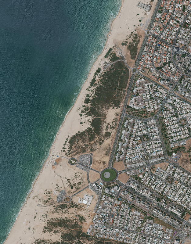 Aerial View of Ashdod-Yam (the beach area)
Click on Image for high resolution magnifiable map
from www.govmap.gov.il
| Transliterated Name | Source | Name |
|---|---|---|
| Ashdod-Yam | Hebrew | |
| Azotus Paralios | Greek | |
| asdudi-immu | Assyrian | |
| aṯdādu | Late Bronze age Canaaanite | |
| Mahuz Azdud | Older Arabic | |
| Minat al-Qal'a | Contempory Arabic | |
| Castellum Beroart | French (Crusades) |
- Fig. 1 - Location Map
from Di Segni et al. (2022)
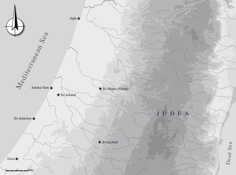 Fig. 1
General location map
(created by Itamar Ben-Ezra)
Di Segni et al. (2022) - Fig. 7 - Geologic Map
of the area from Lorenzon et al. (2022)
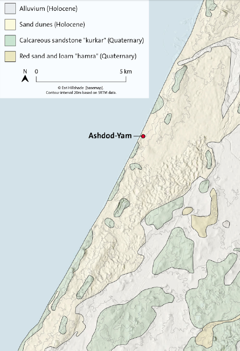 Fig. 7
Geological map of the area
(drawing by Maija Holappa after Sneh and Rosensaft [2004])
Lorenzon et al. (2022)
- Fig. 7 - Geologic Map
of the area from Lorenzon et al. (2022)
Fig. 7
Geological map of the area
(drawing by Maija Holappa after Sneh and Rosensaft [2004])
Lorenzon et al. (2022)
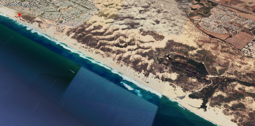
- Annotated Satellite Image (google) of
the Ashdod-Yam from biblewalks.com
- Fig. 3 - Modern Aerial photograph
of Ashdod-Yam from Di Segni et al. (2022)
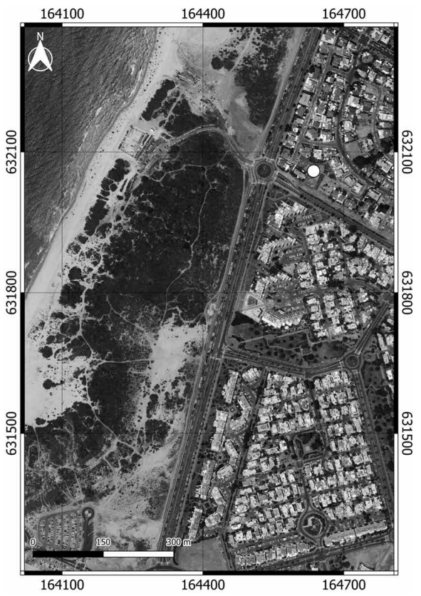 Fig. 3
Modern aerial photograph of Ashdod-Yam. The location of the excavated basilica is marked with a white dot
(created by Yaniv Darvasi)
Di Segni et al. (2022) - Fig. 2 - Aerial photograph
of Ashdod-Yam from 1944 from Di Segni et al. (2022)
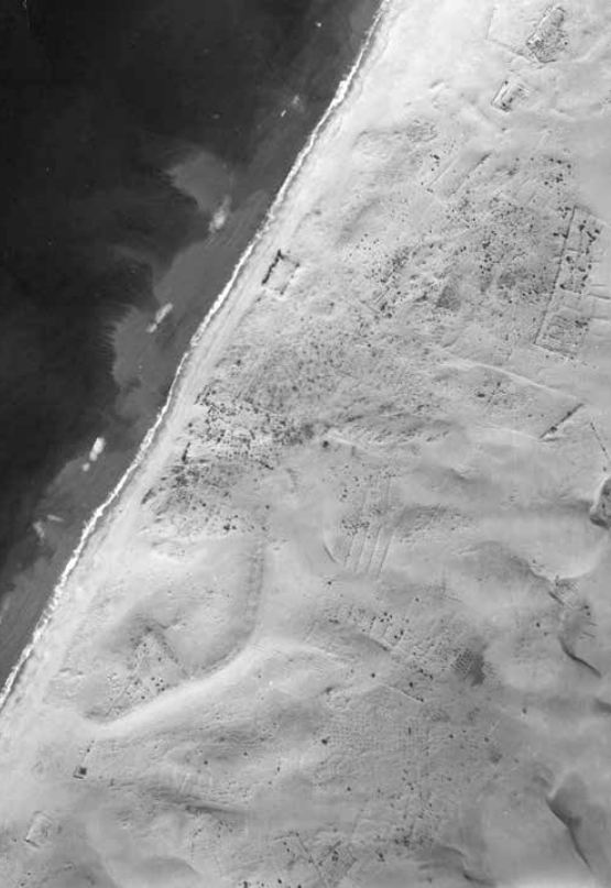 Fig. 2
Aerial photograph of Ashdod-Yam taken in 1944
(courtesy of the Survey of Israel)
Di Segni et al. (2022) - Fig. 2 Annotated Aerial
photograph of Ashdod-Yam from 1944 from Fantalkin et al. (2024)
 Fig. 2
Aerial photograph of Ashdod-Yam taken in 1944, including key landmarks.
(Courtesy of the Survey of Israel.)
Fantalkin et al. (2024) - Fig. 9 LIDAR image of
Ashdod-Yam showing key landmarks from Fantalkin et al. (2024)
 Fig. 9
LIDAR image of Ashdod-Yam showing key landmarks. Kaplan’s excavation trenches are visible along the perimeter of the fortifications
(Created by SEE Advanced Mapping Systems and Solutions Ltd.; courtesy of the authors.)
Fantalkin et al. (2024) - Ashdod-Yam in Google Earth
 Ashdod-Yam
click on image to explore this site on a new tab in Google Earth - Ashdod-Yam on govmap.gov.il
Ashdod-Yam
click on image to explore this site on a new tab in govmap.gov.il

- Fig. 2 Annotated Aerial view
of the acropolis from Fantalkin et al. (2024b)
 Fig. 2
Aerial view of the acropolis (looking south) in 2013, showing the excavated areas
(photo by P. Partouche, Skyview Photography; modified by S. Pirsky)
Fantalkin et al. (2024b)
- Fig. 6 - Oblique aerial photo of Byzantine
Church Complex showing 3 phases from Fantalkin (2023)
 Fig. 6
Church complex (looking West), with its three suggested constructional phases:
- Stage 1 (blue)
- Stage 2 (red)
- Stage 3 (green)
Fantalkin (2023) - Fig. 6 - Orthophoto of excavated Byzantine
Church Complex from Di Segni et al. (2022)
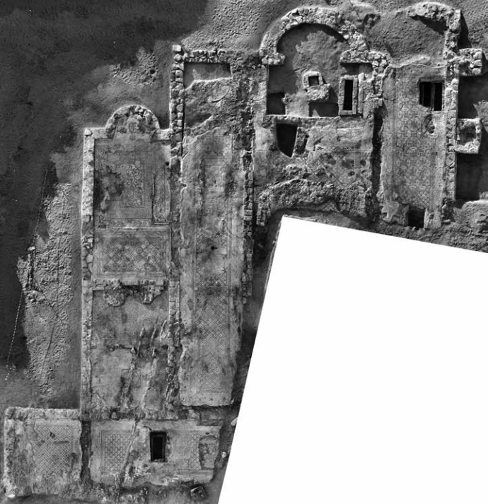 Fig. 6
The orthophoto of the excavated complex
(created by Slava Pirsky and Sergey Alon)
Di Segni et al. (2022)
- Fig. 2 - Aerial View of areas A, B, and D
from Lorenzon et al. (2022)
 Fig. 2
View to the south showing the excavation areas at Ashdod-Yam
- Area A in which the Hellenistic structures were found
- Area B includes part of the fortification wall
- Area D encompasses the acropolis
(Credit: Pascal Partouche, Skyview Photography.)
Lorenzon et al. (2022) - Fig. 11 Aerial photograph
of the acropolis showing Areas A, A1, B, C, and D from Fantalkin et al. (2024)
 Fig. 11
Aerial photograph of the acropolis (looking south) from 2013 showing current excavation areas.
(Photo by P. Partouche, Skyview Photography; courtesy of the authors.)
Fantalkin et al. (2024)
- Fig. 3 General Plan of
the Ashdod-Yam site from Fantalkin et al. (2024)
 Fig. 3
General plan of the Ashdod-Yam site showing the number and location of Kaplan’s excavation trenches (or cross-sections)
(Modified by S. Pirsky, after Kaplan 1969: fig. 2; courtesy of the authors)
Fantalkin et al. (2024)
- Fig. 3 General Plan of
the Ashdod-Yam site from Fantalkin et al. (2024)
Fig. 3
General plan of the Ashdod-Yam site showing the number and location of Kaplan’s excavation trenches (or cross-sections)
(Modified by S. Pirsky, after Kaplan 1969: fig. 2; courtesy of the authors)
Fantalkin et al. (2024)
- Plan of Citadel and
excavation areas of Ashdod-Yam from Stern et. al. (2008)
 Ashdod-Yam: plan of the excavation (Citadel)
Stern et. al. (2008)
- Plan of Citadel and
excavation areas of Ashdod-Yam from Stern et. al. (2008)
Ashdod-Yam: plan of the excavation (Citadel)
Stern et. al. (2008)
- Fig. 5 - Plan of excavated
Byzantine Church Complex from Di Segni et al. (2022)
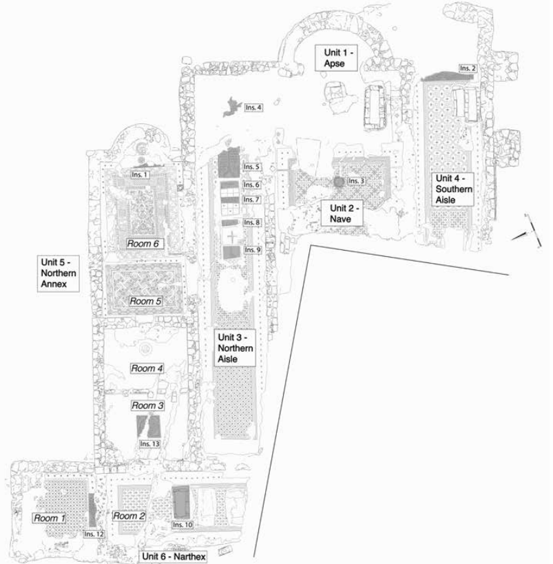 Fig. 5
Plan of the excavated complex and location of the inscriptions
(created by Slava Pirsky and Liora Bouzaglou)
Di Segni et al. (2022) - Fig. 15 Final stratigraphic
and architectural phases of the Byzantine Church Complex from Darvasi et al. (2024)
 Fig. 15
Final stratigraphic and architectural phases of the excavated complex
(created by Slava Pirsky, Liora Bouzaglou, & Alexander Fantalkin)
Darvasi et al. (2024) - Fig. 14 Orthophoto
of the Byzantine Church Complex from Darvasi et al. (2024)
 Fig. 14
Orthophoto at July/August 2021 season end
(created by Slava Pirsky and Sergey Alon)
Darvasi et al. (2024)
- Fig. 5 - Plan of excavated
Byzantine Church Complex from Di Segni et al. (2022)
Fig. 5
Plan of the excavated complex and location of the inscriptions
(created by Slava Pirsky and Liora Bouzaglou)
Di Segni et al. (2022) - Fig. 15 Final stratigraphic
and architectural phases of the Byzantine Church Complex from Darvasi et al. (2024)
Fig. 15
Final stratigraphic and architectural phases of the excavated complex
(created by Slava Pirsky, Liora Bouzaglou, & Alexander Fantalkin)
Darvasi et al. (2024) - Fig. 14 Orthophoto
of the Byzantine Church Complex from Darvasi et al. (2024)
Fig. 14
Orthophoto at July/August 2021 season end
(created by Slava Pirsky and Sergey Alon)
Darvasi et al. (2024)
- Fig. 2 Annotated Aerial view
of the acropolis from Fantalkin et al. (2024b)
Fig. 2
Aerial view of the acropolis (looking south) in 2013, showing the excavated areas
(photo by P. Partouche, Skyview Photography; modified by S. Pirsky)
Fantalkin et al. (2024b) - Fig. 3 - Excavation Areas
A, A1, B, C, and D from Lorenzon et al. (2022)
 Fig. 3
Map of excavation areas in Ashdod Yam
(Credit: Slava Pirskiy)
Lorenzon et al. (2022) - Fig. 12 Excavation Areas
A, A1, B, C, and D from Fantalkin et al. (2024)
 Fig. 12
Map of current excavation areas
(Drawing by S. Pirsky; courtesy of the authors)
Fantalkin et al. (2024)
- Fig. 2 Annotated Aerial view
of the acropolis from Fantalkin et al. (2024b)
Fig. 2
Aerial view of the acropolis (looking south) in 2013, showing the excavated areas
(photo by P. Partouche, Skyview Photography; modified by S. Pirsky)
Fantalkin et al. (2024b) - Fig. 3 - Excavation Areas
A, A1, B, C, and D from Lorenzon et al. (2022)
Fig. 3
Map of excavation areas in Ashdod Yam
(Credit: Slava Pirskiy)
Lorenzon et al. (2022) - Fig. 12 Excavation Areas
A, A1, B, C, and D from Fantalkin et al. (2024)
Fig. 12
Map of current excavation areas
(Drawing by S. Pirsky; courtesy of the authors)
Fantalkin et al. (2024)
- Fig. 5 - Plan of Area D
from Lorenzon et al. (2022)
 Fig. 5
Plan of Area D with Iron Age and Hellenistic remains
(Credit: Slava Pirskiy and Eli Itkin)
Lorenzon et al. (2022)
- Fig. 5 - Plan of Area D
from Lorenzon et al. (2022)
Fig. 5
Plan of Area D with Iron Age and Hellenistic remains
(Credit: Slava Pirskiy and Eli Itkin)
Lorenzon et al. (2022)
- Fig. 4 Plan of Area A
from Fantalkin et al. (2024b)
 Fig. 4
Plan of Area A
(drawing by S. Pirsky)
Fantalkin et al. (2024b) - Fig. 5 Unit 1 in Area A
featuring evidence of the mudbrick wall collapse from Fantalkin et al. (2024b)
 Fig. 5
Unit 1 in Area A, featuring evidence of the mudbrick wall collapse
(drawing by S. Pirsky; photo by P. Partouche, Skyview Photography)
Fantalkin et al. (2024b)
- Fig. 4 Plan of Area A
from Fantalkin et al. (2024b)
Fig. 4
Plan of Area A
(drawing by S. Pirsky)
Fantalkin et al. (2024b) - Fig. 5 Unit 1 in Area A
featuring evidence of the mudbrick wall collapse from Fantalkin et al. (2024b)
Fig. 5
Unit 1 in Area A, featuring evidence of the mudbrick wall collapse
(drawing by S. Pirsky; photo by P. Partouche, Skyview Photography)
Fantalkin et al. (2024b)
- Fig. 28 Reconstruction
of the Stratum II settlement from Fantalkin et al. (2024b)
 Fig. 28
Reconstruction of the Stratum II settlement
(drawing by S. Pirsky)
Fantalkin et al. (2024b)
- Fig. 28 Reconstruction
of the Stratum II settlement from Fantalkin et al. (2024b)
Fig. 28
Reconstruction of the Stratum II settlement
(drawing by S. Pirsky)
Fantalkin et al. (2024b)
- Fig. 21 - Destruction
debris in the Byzantine Chapel from Di Segni et al. (2022)
 Fig. 21
The destruction debris during the excavations of the chapel in Unit 5
(photo taken by Sasha Flit)
Di Segni et al. (2022) - Fig. 22 - Destruction
debris in the Byzantine nave from Di Segni et al. (2022)
 Fig. 22
The destruction debris during the excavations of the nave in Unit 2
(photo taken by Sasha Flit)
Di Segni et al. (2022) - Fig. 6 - Collapsed
Hellenistic mudbricks in Area A from Lorenzon et al. (2022)
 Fig. 6
Hellenistic remains in Area A, showing the mudbricks still in situ and the mudbricks that have collapsed from the upper portion of the wall
(Credit: Pascal Partouche, Skyview Photography)
Lorenzon et al. (2022) - Fig. 6 Unit 1 in Area A
Wall W.117 built of mudbrick directly on sand from Fantalkin et al. (2024b)
 Fig. 6
Unit 1 in Area A: W.117, built of mudbricks directly on sand, looking northeast
(photo by P. Shrago)
Fantalkin et al. (2024b)
- Fig. 21 - Destruction
debris in the Byzantine Chapel from Di Segni et al. (2022)
Fig. 21
The destruction debris during the excavations of the chapel in Unit 5
(photo taken by Sasha Flit)
Di Segni et al. (2022) - Fig. 22 - Destruction
debris in the Byzantine nave from Di Segni et al. (2022)
Fig. 22
The destruction debris during the excavations of the nave in Unit 2
(photo taken by Sasha Flit)
Di Segni et al. (2022) - Fig. 6 - Collapsed
Hellenistic mudbricks in Area A from Lorenzon et al. (2022)
Fig. 6
Hellenistic remains in Area A, showing the mudbricks still in situ and the mudbricks that have collapsed from the upper portion of the wall
(Credit: Pascal Partouche, Skyview Photography)
Lorenzon et al. (2022) - Fig. 6 Unit 1 in Area A
Wall W.117 built of mudbrick directly on sand from Fantalkin et al. (2024b)
Fig. 6
Unit 1 in Area A: W.117, built of mudbricks directly on sand, looking northeast
(photo by P. Shrago)
Fantalkin et al. (2024b)
 Table 1
A chronological scheme for the Levant (after Finkelstein 2010 and 2011; Regev et al. 2012; Sharon 2013).
Palmisano et al. (2019)
- Fig. 2 - Aerial View of area A, B, and D
from Lorenzon et al. (2022)
Fig. 2
View to the south showing the excavation areas at Ashdod-Yam
- Area A in which the Hellenistic structures were found
- Area B includes part of the fortification wall
- Area D encompasses the acropolis
(Credit: Pascal Partouche, Skyview Photography.)
Lorenzon et al. (2022) - Plan of Citadel and excavation
areas of Ashdod-Yam from Stern et. al. (2008)
Ashdod-Yam: plan of the excavation (Citadel)
Stern et. al. (2008) - Fig. 3 - Excavation Areas
A, A1, B, C, and D from Lorenzon et al. (2022)
Fig. 3
Map of excavation areas in Ashdod Yam
(Credit: Slava Pirskiy)
Lorenzon et al. (2022) - Fig. 5 - Plan of Area D
from Lorenzon et al. (2022)
Fig. 5
Plan of Area D with Iron Age and Hellenistic remains
(Credit: Slava Pirskiy and Eli Itkin)
Lorenzon et al. (2022) - Fig. 6 - Collapsed Hellenistic mudbricks
in Area A from Lorenzon et al. (2022)
Fig. 6
Hellenistic remains in Area A, showing the mudbricks still in situ and the mudbricks that have collapsed from the upper portion of the wall
(Credit: Pascal Partouche, Skyview Photography)
Lorenzon et al. (2022)
- Plan of Citadel and excavation
areas of Ashdod-Yam from Stern et. al. (2008)
Ashdod-Yam: plan of the excavation (Citadel)
Stern et. al. (2008) - Fig. 3 - Excavation Areas
A, A1, B, C, and D from Lorenzon et al. (2022)
Fig. 3
Map of excavation areas in Ashdod Yam
(Credit: Slava Pirskiy)
Lorenzon et al. (2022) - Fig. 5 - Plan of Area D
from Lorenzon et al. (2022)
Fig. 5
Plan of Area D with Iron Age and Hellenistic remains
(Credit: Slava Pirskiy and Eli Itkin)
Lorenzon et al. (2022) - Fig. 6 - Collapsed Hellenistic mudbricks
in Area A from Lorenzon et al. (2022)
Fig. 6
Hellenistic remains in Area A, showing the mudbricks still in situ and the mudbricks that have collapsed from the upper portion of the wall
(Credit: Pascal Partouche, Skyview Photography)
Lorenzon et al. (2022)
- Fig. 5 - Plan of excavated Byzantine
Church Complex from Di Segni et al. (2022)
Fig. 5
Plan of the excavated complex and location of the inscriptions
(created by Slava Pirsky and Liora Bouzaglou)
Di Segni et al. (2022) - Fig. 6 - Orthophoto of excavated Byzantine
Church Complex from Di Segni et al. (2022)
Fig. 6
The orthophoto of the excavated complex
(created by Slava Pirsky and Sergey Alon)
Di Segni et al. (2022) - Fig. 21 - Destruction debris in the Byzantine
Chapel from Di Segni et al. (2022)
Fig. 21
The destruction debris during the excavations of the chapel in Unit 5
(photo taken by Sasha Flit)
Di Segni et al. (2022) - Fig. 22 - Destruction debris in the Byzantine
nave from Di Segni et al. (2022)
Fig. 22
The destruction debris during the excavations of the nave in Unit 2
(photo taken by Sasha Flit)
Di Segni et al. (2022)
| Effect | Location | Image (s) | Comments |
|---|---|---|---|
| Collapsed walls | Area A and D
Fig. 2 Aerial view of the acropolis (looking south) in 2013, showing the excavated areas (photo by P. Partouche, Skyview Photography; modified by S. Pirsky) Fantalkin et al. (2024b)
Fig. 28Reconstruction of the Stratum II settlement (drawing by S. Pirsky) Fantalkin et al. (2024b) |
Fig. 6 Hellenistic remains in Area A, showing the mudbricks still in situ and the mudbricks that have collapsed from the upper portion of the wall (Credit: Pascal Partouche, Skyview Photography) Lorenzon et al. (2022)
Fig. 6Unit 1 in Area A: W.117, built of mudbricks directly on sand, looking northeast (photo by P. Shrago) Fantalkin et al. (2024b) |
|
| Effect | Location | Image (s) | Comments |
|---|---|---|---|
| Collapsed walls and roof Debris |
Unit 2 (Nave) and Unit 5 (N Aisle)
Fig. 5 Plan of the excavated complex and location of the inscriptions (created by Slava Pirsky and Liora Bouzaglou) Di Segni et al. (2022) |
Fig. 22 The destruction debris during the excavations of the nave in Unit 2 (photo taken by Sasha Flit) Di Segni et al. (2022)
Fig. 21The destruction debris during the excavations of the chapel in Unit 5 (photo taken by Sasha Flit) Di Segni et al. (2022) |
|
- Earthquake Archeological Effects chart
of Rodríguez-Pascua et al (2013: 221-224)
 Earthquake Archeological Effects (EAE)
Rodríguez-Pascua et al (2013: 221-224)
| Effect | Location | Image (s) | Comments | Intensity |
|---|---|---|---|---|
| Collapsed walls | Area A and D
Fig. 2 Aerial view of the acropolis (looking south) in 2013, showing the excavated areas (photo by P. Partouche, Skyview Photography; modified by S. Pirsky) Fantalkin et al. (2024b)
Fig. 28Reconstruction of the Stratum II settlement (drawing by S. Pirsky) Fantalkin et al. (2024b) |
Fig. 6 Hellenistic remains in Area A, showing the mudbricks still in situ and the mudbricks that have collapsed from the upper portion of the wall (Credit: Pascal Partouche, Skyview Photography) Lorenzon et al. (2022)
Fig. 6Unit 1 in Area A: W.117, built of mudbricks directly on sand, looking northeast (photo by P. Shrago) Fantalkin et al. (2024b) |
|
VIII+ |
- Earthquake Archeological Effects chart
of Rodríguez-Pascua et al (2013: 221-224)
Earthquake Archeological Effects (EAE)
Rodríguez-Pascua et al (2013: 221-224)
| Effect | Location | Image (s) | Comments | Intensity |
|---|---|---|---|---|
| Collapsed walls and roof Debris |
Unit 2 (Nave) and Unit 5 (N Aisle)
Fig. 5 Plan of the excavated complex and location of the inscriptions (created by Slava Pirsky and Liora Bouzaglou) Di Segni et al. (2022) |
Fig. 22 The destruction debris during the excavations of the nave in Unit 2 (photo taken by Sasha Flit) Di Segni et al. (2022)
Fig. 21The destruction debris during the excavations of the chapel in Unit 5 (photo taken by Sasha Flit) Di Segni et al. (2022) |
|
VIII + |