Area J-East in the archaeological site of Aila preserves one of the most detailed archaeoseismic records along the southern Dead Sea Transform. Located approximately 500 m north of the modern shoreline of the Gulf of Aqaba and about 500 m northwest of the later Islamic city of Ayla, the Nabatean, Roman, Byzantine, and Early Islamic occupation sequence spans from the first century CE through the Early Islamic period. Aila occupies a tectonic setting at the northern end of the Gulf of Aqaba where left-lateral motion on the Aqaba Fault is transferred westward across the Wadi Arabah by a series of shoreline-parallel normal cross faults. One of these active faults (CF-5) intersects the western part of Area J-East, providing a rare opportunity to document repeated surface faulting, structural damage, repair, and stratigraphic displacement within a well-dated archaeological sequence.
Thomas et al. (2007:66) reported that Earthquake IV affected Area J-East after a prolonged period of abandonment. They identified a fault rupture and associated earthquake damage that they attributed to an event in the early to mid-seventh century CE, noting that “the pottery constrains the date of Earthquake IV to sometime between the seventh century and mid-seventh to eighth century,” concluding that “in this case, an early to mid-seventh-century date would best fit the dating evidence.”
Thomas et al. (2007:66) measured 12 cm of dip-slip across Fault D in Section C and "up to 30 cm of lateral motion on wall J.1:53." However, they concluded that strike-slip during Earthquake IV was "probably minimal" because Fault D had also slipped during Earthquakes V and VI, particularly Earthquake V, which produced substantially greater structural damage and therefore likely accounted for most of the cumulative lateral displacement.
- Fig. 1b Quaternary Geologic
Map of the Southern Arava from Thomas et al (2007)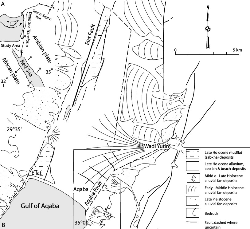
Quaternary geologicmap of the region along the Dead Sea Transform north of the Gulf of Aqaba, showing the geometry offaults in the region of Aqaba, Jordan, and Elat, Israel (modified after Garfunkel 1970).
Click on image to open in a new tab
Thomas et al (2007)- Fig 2.8 b Map showing location of
location of Area J-east from Niemi (2014)
Map of Aqaba showing the three archaeological sites near the coast, some major roads, and location of cross faults and possible Aqaba fault strands.
Click on image to open in a new tab
Niemi (2014)- Fig. 2.15 Plan of Area J-east
from Thomas et al (2007)
Faults exposed in the Roman Aqaba Project excavation Area J-East
Click on image to open in a new tab
Niemi - Chapter 2 from Parker et al (2014)- Fig. 3 Composite columnar
stratigraphic section for J-east site from Thomas et al (2007)
Schematic columnar stratigraphic section of the deposits at the J-East site, showing mudbrick tumble from earthquakes on floor levels, sand horizons, occupational levels, and earthquake event horizons.
Click on image to open in a new tab
Thomas et al (2007)- Fig. 4 Section drawing of Wall
26 and Wall 48 showing earthquake damage and fault offsets from Thomas et al. (2007)
Section drawing of Wall 26 and Wall 48, showing earthquake damage and fault offsets.
Click on image to open in a new tab
Thomas et al. (2007)- Fig. 5 Section B stratigraphic
section showing mapped faults from Thomas et al. (2007)
Stratigraphic section of the south and north baulks of J-1, showing mapped faults.
Click on image to open in a new tab
Thomas et al. (2007)- Fig. 5 Section A stratigraphic
section showing mapped faults from Thomas et al. (2007)
Stratigraphic section of the south and north baulks of J-1, showing mapped faults.
Click on image to open in a new tab
Thomas et al. (2007)Deformation Map
click on image to open in a new tab
Modified by JW from Fig. 2 of Thomas et al (2007)