Safed
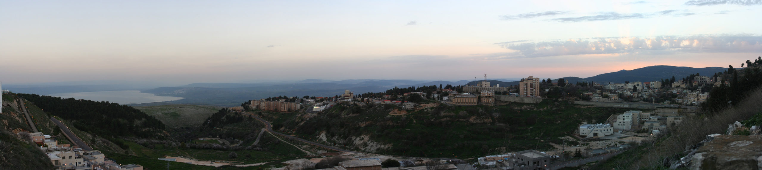 View of Safed from the NE with the Sea of Galilee in the distance
Beivushtang - Wikipedia - CC BY-SA 3.0
| Transliterated Name | Language | Name |
|---|---|---|
| Safed | English | |
| Zefat | English | |
| Tzfat | Hebrew | צְפַת |
| Tzephath | Hebrew - Talmud | |
| Safad | Arabic | صفد |
| Seph | mentioned by Josephus in The Jewish War (II,573) | |
| Tziphoth | possibly Safed in Egyptian hieratic M.S. called ‘Travels of a Mohar’ (‘Records of the Past,’ vol. ii. p. 62) |
- Annotated Satellite Photo
of Safed from BibleWalks.com
- Fig. 1 - Aerial View of Safed
showing location of the fortress from Delali-Amos (2013)
 Fig. 1
Location Map
Delali-Amos (2013) - Fig. 1 - Water Supply
Map of Safed and surroundings from Shivtiel et al (2022)
 Figure 1
The supply of water to Safed and its surroundings.
used with permission from Yinon Shivtiel
Shivtiel et al (2022) - Safed in Google Earth
 Safed
Safed
click on image to explore this site on a new tab in Google Earth - Safed on govmap.gov.il
 Safed on govmap.gov.il
click on image to explore this site on a new tab in govmap.gov.il

- Fig. 2a -
Geological Map of Area from Katz and Crouvi (2007)
 Fig. 2a
Geological map of the studied area (Levitte, 2001; anthropogenic material mapped in the frame of this work). The current Zefat city limits are marked by a blue solid line
Katz and Crouvi (2007) - Fig. 2b -
Geological Map of Safed from Katz and Crouvi (2007)
 Fig. 2b
The core (historical) city area. The core city extended from the Citadel, westwards to the old cemetery (α). Sites of field-observed slope instability are marked by black arrows. Also shown are upslope limits of EILS area in the 1759 and 1837 earthquakes (β and γ, respectively) according to reported damage to synagogues (marked by close squares where
- Sefaradic Ari
- Banea
- Hagadol/Abuhav
- Greek pilgrimages/Ashkenazic Ari
- Karo
- Elshiech
Katz and Crouvi (2007) - Fig. 2c -
Geological cross section from Katz and Crouvi (2007)
 Fig. 2c
West– East (A–A') geological cross section through the Citadel and the core city of Zefat; location is shown in a (the thickness of the anthropogenic talus is approximated).
Katz and Crouvi (2007) - Fig. 2 a, b, and c -
Legend from Katz and Crouvi (2007)
 Fig. 2
Legend for Figure 2 a, b, and c
Katz and Crouvi (2007) - Fig. 5 -
Geotechnical Map from Katz and Crouvi (2007)
 Fig. 5
Map of the geotechnical units in the area studied (for details see Tables 1 and 2). The core (old) city extends from the citadel (marked by a triangle) westwards toward the city limits.
Katz and Crouvi (2007) - Fig. 5 -
Legend from Katz and Crouvi (2007)
 Fig. 5 Legend
Legend for Figure 5
Katz and Crouvi (2007) - Fig. 6 -
Map of calculated critical acceleration from Katz and Crouvi (2007)
 Fig. 6
Map of calculated critical acceleration in the study area. The core (old) city extends from the citadel (marked by a triangle) westwards toward the city limits
Katz and Crouvi (2007) - Fig. 6 -
Legend from Katz and Crouvi (2007)
 Fig. 6
Critical Acceleration Map Legend
Katz and Crouvi (2007) - Fig. 7a -
Newmark displacement map for 1759 Safed Quake (area) from Katz and Crouvi (2007)
 Fig. 7a
Calculated Newmark displacement maps of two historical earthquakes used to calibrate the mechanical model, (a–b) October 1759 Mw = 6, R= 15 earthquake
Katz and Crouvi (2007) - Fig. 7b -
Newmark displacement map for 1759 Safed Quake (city) from Katz and Crouvi (2007)
 Fig. 7b
Calculated Newmark displacement maps of two historical earthquakes used to calibrate the mechanical model, (a–b) October 1759 Mw = 6, R= 15 earthquake.
For inferred location of epicenter see text and Fig. 1. Also shown are upslope limits of EILS area in the 1759 and 1837 earthquakes ( β and γ, respectively, see Fig. 2) traced according to reported damage to synagogues (marked by numbered close squares, see Fig. 2).
Katz and Crouvi (2007) - Fig. 7c -
Newmark displacement map for 1837 Safed Quake (area) from Katz and Crouvi (2007)
 Fig. 7c
Calculated Newmark displacement maps of two historical earthquakes used to calibrate the mechanical model, (c–d) January 1837 Mw = 7, R= 10 earthquake.
For inferred location of epicenter see text and Fig. 1. Also shown are upslope limits of EILS area in the 1759 and 1837 earthquakes ( β and γ, respectively, see Fig. 2) traced according to reported damage to synagogues (marked by numbered close squares, see Fig. 2).
Katz and Crouvi (2007) - Fig. 7d -
Newmark displacement map for 1837 Safed Quake (city) from Katz and Crouvi (2007)
 Fig. 7d
Calculated Newmark displacement maps of two historical earthquakes used to calibrate the mechanical model, (c–d) January 1837 Mw = 7, R= 10 earthquake.
For inferred location of epicenter see text and Fig. 1. Also shown are upslope limits of EILS area in the 1759 and 1837 earthquakes ( β and γ, respectively, see Fig. 2) traced according to reported damage to synagogues (marked by numbered close squares, see Fig. 2).
Katz and Crouvi (2007) - Fig. 9a -
Newmark displacement map for MW = 6 earthquake from Katz and Crouvi (2007)
 Fig. 9a
Examples of calculated Newmark displacement maps (EILS hazard) in scenario earthquakes.
- MW = 6
- R= 10 km, 25 km, 50 km and 100 km
Katz and Crouvi (2007) - Fig. 9b -
Newmark displacement map for MW = 7 earthquake from Katz and Crouvi (2007)
 Fig. 9b
Examples of calculated Newmark displacement maps (EILS hazard) in scenario earthquakes.
- MW = 7
- R= 10 km, 25 km, 50 km and 100 km
Katz and Crouvi (2007)
- Plan of the Citadel
from Stern et al (2008)
 Safed: Plan of the Citadel
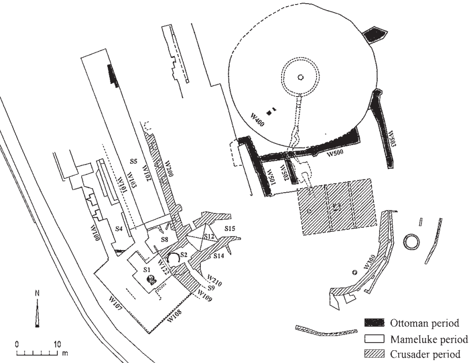
Stern et al (2008) - Fig. 1 - Plan of the
S and SW corners of the fortress from Barbé and Damati (2005)
 Fig. 1
Schematic plan of archaeological remains in the southern and southwestern sectors of the fortress.
Barbé and Damati (2005) - Plan of the Citadel
in Safed from the PEF Survey of Palestine map (1871-1877) - from Wikipedia
 Kulat Safed from the 1871-77 Palestine Exploration Fund Survey of Palestine
Palestine Exploration Fund - Wikipedia - Public Domain
- Pl. I - Drawing of the Castle of Safed
by Wilson in 1880 - from Huygens (1981)

Plate I
Drawing of Wilson (1880), see note 47
Note 47 - The other (Plate IV) is in the book by EW Schulz, Reise in das gelobte Land, Mülheim ad Ruhr, 1852, between p. 64 and 65. The engraving is interesting because it shows the castle up close, seen from the southwest. By contrast, the view of the fortress found in CW Wilson, Picturesque Palestine, II, London, 1880, p. 91 [= G. Ebers and H. Guthe, Palastina, 1, Stuttgart, 1882, p. 341], beautiful as it is (plate I), presents no detail of comparable value, any more than the description of Safed on pages 74 and 92-93; the engraving showing the Jewish quarter (p. 90), was reproduced by Y. Ben-Arieh (see below, n. 51), p. 228.
Huygens (1981) - Pl. I - Closeup on the Citadel of
Drawing of the Castle of Safed by Wilson in 1880 - from Huygens (1981)

Plate I Closeup
Drawing of Wilson (1880), see note 47
Note 47 - The other (Plate IV) is in the book by EW Schulz, Reise in das gelobte Land, Mülheim ad Ruhr, 1852, between p. 64 and 65. The engraving is interesting because it shows the castle up close, seen from the southwest. By contrast, the view of the fortress found in CW Wilson, Picturesque Palestine, II, London, 1880, p. 91 [= G. Ebers and H. Guthe, Palastina, 1, Stuttgart, 1882, p. 341], beautiful as it is (plate I), presents no detail of comparable value, any more than the description of Safed on pages 74 and 92-93; the engraving showing the Jewish quarter (p. 90), was reproduced by Y. Ben-Arieh (see below, n. 51), p. 228.
Huygens (1981) - Pl. III - Drawing of Safed
from the northeast by (Bartlett-) Willmore in 1851 - from Huygens (1981)

Plate III
Safed seen from the northeast, engraving by (Bartlett-) Willmore (1851), see p. 21-22.
What makes Bartlett's book important for us is that between p. 208 and p. 209 is an engraving (by A. Willmore): among the views of the castle that I know, it is one of the two that are of real interest (note 47) . It betrays enough of the romantic era, but although it singularly mistreats the perspective of the landscape, it is of all importance for a few details. The ruined fortress is there on the right on the hill (see plate iii). One notices there first, seen from the North-East, an enclosure; the visible part has eight towers, seven of which are circular. Only the eighth, the leftmost, may not be. It must be the first enclosure, because the thin remains which in the foreground are observed on the deforested hill, lower than the enclosure with the eight turns, could not be taken for those of the first enclosure. Neither the first nor the second ditch can be distinguished. Inside the fortress there are considerable remains of a distinctly square keep, well in the architectural traditions of the Templars, together with those of another square tower and a large building to the right. The dungeon is to the south, near Tiberias48. In the background, in the plain, also on the south side, we still see a large square work with two equally square towers. Between this work and the castle extends the white city of Safed. To the left of the city, on a hill overlooking the lake, there is a small tower, which was undoubtedly to ensure the connection between the castle and the city of Tiberias by means of fire signals49.
Huygens (1981) - Pl. III - Closeup on the Citadel of
Drawing of Safed from the northeast by (Bartlett-) Willmore in 1851 - from Huygens (1981)

Plate III Closeup
Safed seen from the northeast, engraving by (Bartlett-) Willmore (1851), see p. 21-22.
What makes Bartlett's book important for us is that between p. 208 and p. 209 is an engraving (by A. Willmore): among the views of the castle that I know, it is one of the two that are of real interest (note 47) . It betrays enough of the romantic era, but although it singularly mistreats the perspective of the landscape, it is of all importance for a few details. The ruined fortress is there on the right on the hill (see plate iii). One notices there first, seen from the North-East, an enclosure; the visible part has eight towers, seven of which are circular. Only the eighth, the leftmost, may not be. It must be the first enclosure, because the thin remains which in the foreground are observed on the deforested hill, lower than the enclosure with the eight turns, could not be taken for those of the first enclosure. Neither the first nor the second ditch can be distinguished. Inside the fortress there are considerable remains of a distinctly square keep, well in the architectural traditions of the Templars, together with those of another square tower and a large building to the right. The dungeon is to the south, near Tiberias48. In the background, in the plain, also on the south side, we still see a large square work with two equally square towers. Between this work and the castle extends the white city of Safed. To the left of the city, on a hill overlooking the lake, there is a small tower, which was undoubtedly to ensure the connection between the castle and the city of Tiberias by means of fire signals49.
Huygens (1981) - Pl. IV - Drawing of Safed
from the southwest by Schulz in 1852 - from Huygens (1981)

Plate IV
Safed seen from the southwest, engraving by Schulz (1852), see note 47.
Note 47 - The other (Plate IV) is in the book by EW Schulz, Reise in das gelobte Land, Mülheim ad Ruhr, 1852, between p. 64 and 65. The engraving is interesting because it shows the castle up close, seen from the southwest. By contrast, the view of the fortress found in CW Wilson, Picturesque Palestine, II, London, 1880, p. 91 [= G. Ebers and H. Guthe, Palastina, 1, Stuttgart, 1882, p. 341], beautiful as it is (plate I), presents no detail of comparable value, any more than the description of Safed on pages 74 and 92-93; the engraving showing the Jewish quarter (p. 90), was reproduced by Y. Ben-Arieh (see below, n. 51), p. 228.
Huygens (1981)
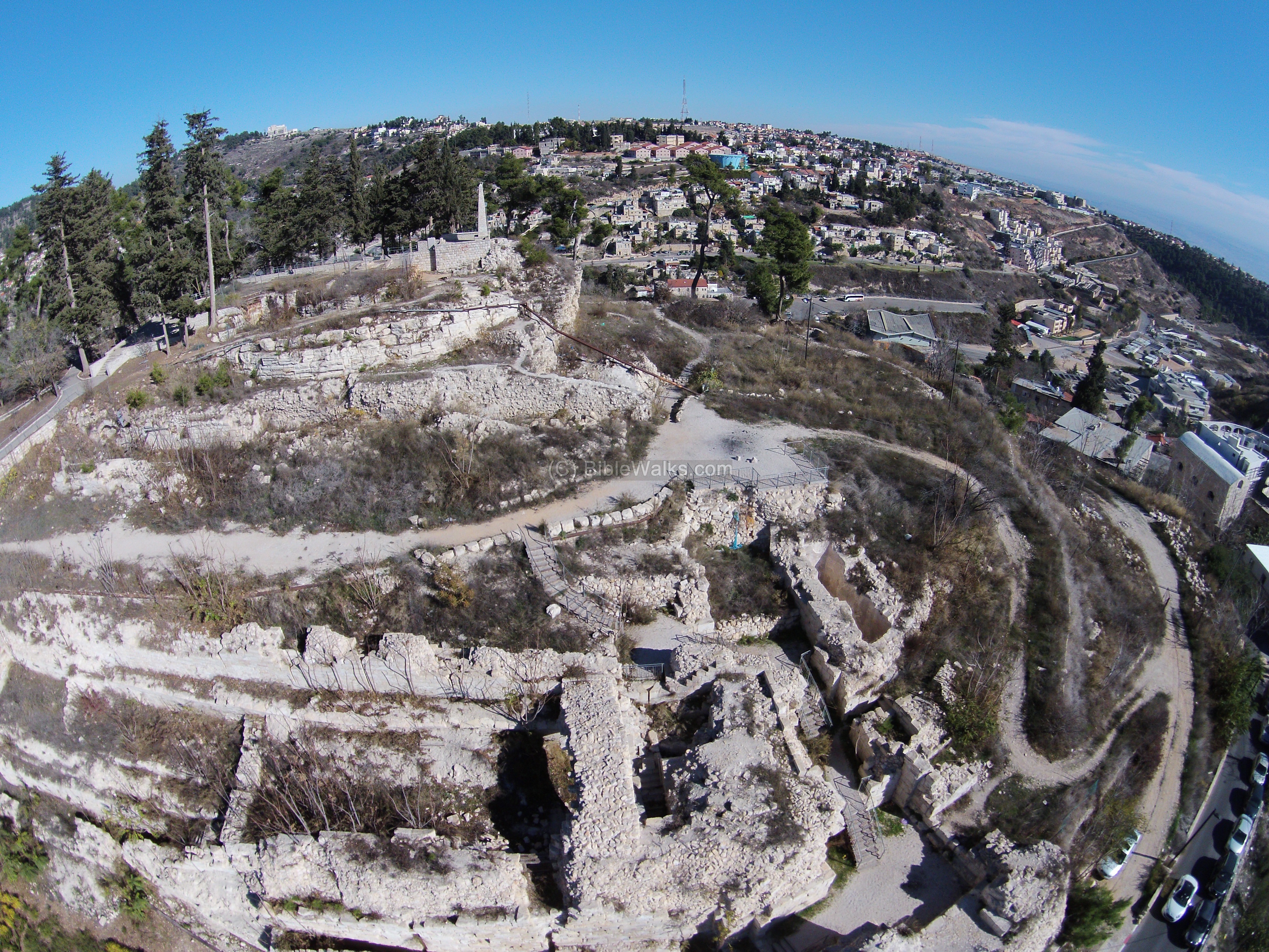
- Aerial Photo of the Ruins at the Citadel in Safed
from BibleWalks.com
 Aerial View of the Citadel in Safed showing the SW side of the hill showing main
visible fortifications, including the south gate. The lower section of the gate and the upper section on the
summit are Mamluke ruins, while the middle range are walls from the Crusaders period.
Aerial View of the Citadel in Safed showing the SW side of the hill showing main
visible fortifications, including the south gate. The lower section of the gate and the upper section on the
summit are Mamluke ruins, while the middle range are walls from the Crusaders period.
(click on photo to open up a high resolution magnifiable image)
used with permission from BibleWalks.com - Link to YouTube Video of the Castle Area from BibleWalks.com
- Photo of the Ruins at the Citadel in Safed
as of 2008 - from Wikipedia
 Safed Citadel in 2008
Almog - Wikipedia - Public Domain - Pl. II - 1947 photo of a round tower
on the Citadel in Safed - from Huygens (1981)

Plate II
Remains of a round tower embedded in a tower of Daher el Omar, see note 41
Note 41 - See plate II (remains of a round tower embedded in a tower of Daher el Omar. Northwestern part of the hill, photo taken August 7, 1947. Photo Israeli Department of Antiquities and Museums in Jerusalem).
JW: Note broken "corner" in the center of the photo aligned with a joint in the encasing tower.
Huygens (1981) - Fig. 7 - Deformed Ottoman Arch
on the Citadel in Safed - from Delali-Amos (2013)
 Figure 7
Wall 2 from the Mamluk period below the vault from the Ottoman period, looking north.
JW: Note distorted arch and protruding voussoir
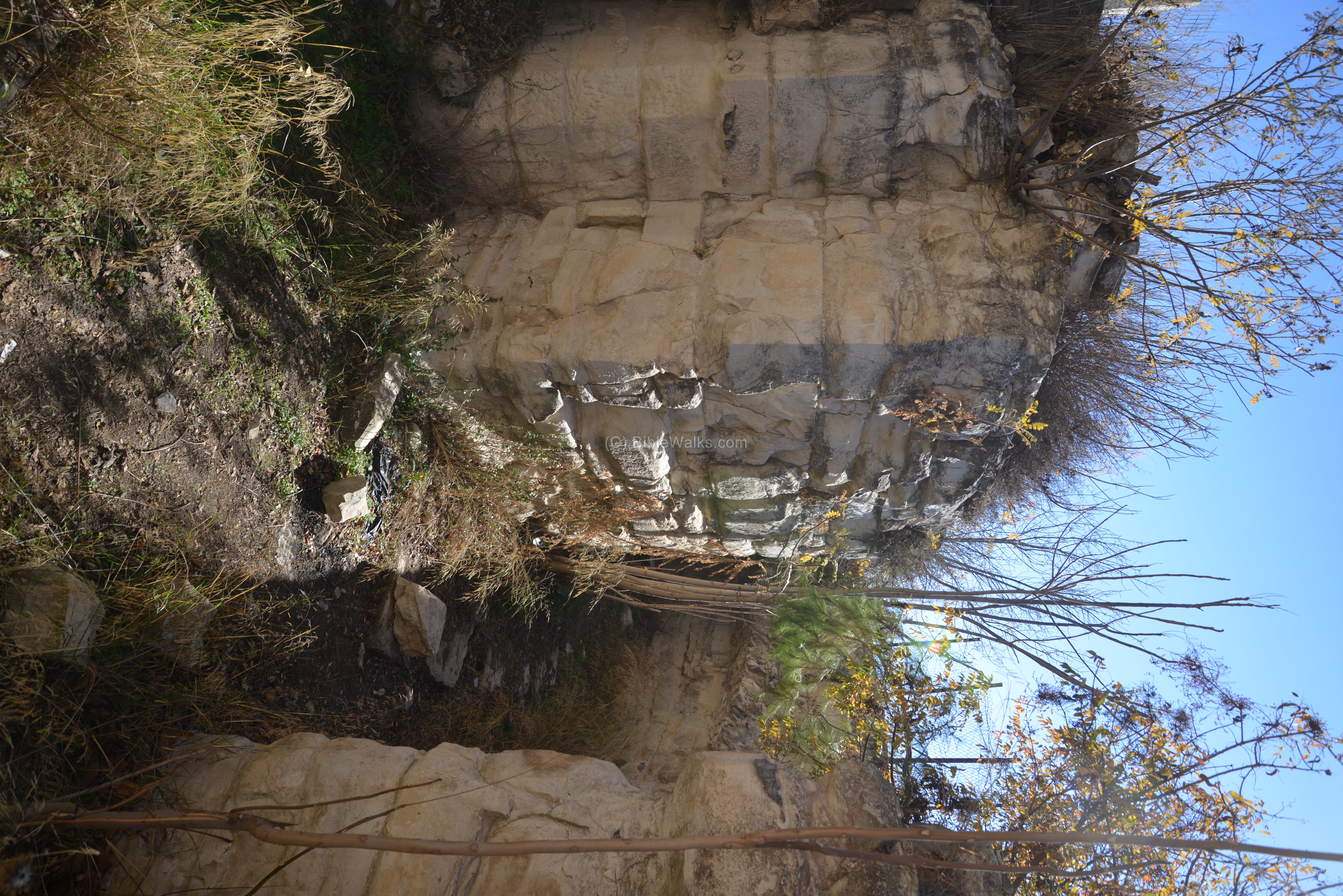
Delali-Amos (2013) - Corridor in the Castle at Safed
showing fractured stones and through-going joints - from BibleWalks.com
 Corridor in the Castle at Safed showing fractured stones and through-going joints.
(click on photo to open up a high resolution magnifiable image)
used with permission from BibleWalks.com - Vault Damage in the Tunnels near the
home of Aharon Botzer in the Old City (Jewish Quarter) in Safed
 Vault Damage in the Tunnels near the home of Aharon Botzer.
The damage repair traverses where the lightbulb is.
According to Aharon Botzer, this displacement occurred during the 1837 CE earthquake.
Vault Damage in the Tunnels near the home of Aharon Botzer.
The damage repair traverses where the lightbulb is.
According to Aharon Botzer, this displacement occurred during the 1837 CE earthquake.
Photo by Jefferson Williams on 18 May 2023
- Fig. 2a -
Geological Map of Area from Katz and Crouvi (2007)
Fig. 2a
Geological map of the studied area (Levitte, 2001; anthropogenic material mapped in the frame of this work). The current Zefat city limits are marked by a blue solid line
Katz and Crouvi (2007) - Fig. 2b -
Geological Map of Safed from Katz and Crouvi (2007)
Fig. 2b
The core (historical) city area. The core city extended from the Citadel, westwards to the old cemetery (α). Sites of field-observed slope instability are marked by black arrows. Also shown are upslope limits of EILS area in the 1759 and 1837 earthquakes (β and γ, respectively) according to reported damage to synagogues (marked by close squares where
- Sefaradic Ari
- Banea
- Hagadol/Abuhav
- Greek pilgrimages/Ashkenazic Ari
- Karo
- Elshiech
Katz and Crouvi (2007) - Fig. 2c -
Geological cross section from Katz and Crouvi (2007)
Fig. 2c
West– East (A–A') geological cross section through the Citadel and the core city of Zefat; location is shown in a (the thickness of the anthropogenic talus is approximated).
Katz and Crouvi (2007) - Fig. 2 a, b, and c -
Legend from Katz and Crouvi (2007)
Fig. 2
Legend for Figure 2 a, b, and c
Katz and Crouvi (2007)
Katz and Crouvi (2007:65) report that
the core city was severely damagedin the earthquakes of 1759 CE
with about 150 fatalities, most of them in the earlier shock (Schiller, 2002; Ya'ari, 1943). They further report that
the majority of the damage occurred in the downhill (western) parts of the core city (Fig. 2b), apparently due to landslides (Yizrael, 2002a). They added that
the synagogues of the Sefaradic Ari and Banea that were damaged in the 1759 earthquake (probably the first) mark the upper landslide boundary (β in Fig. 2b), while the more eastern ones, the Greek pilgrimage and Hagadol (the big) synagogues, were not damaged (Yizrael, 2002a).
- Ruins from the Abuhav Synagogue from zissil.com
 Ruins from original Abuhav structure
zissil.com
zissil.com reports that all existing synagogues in Safed were destroyed in 1759 CE except for the Alsheich synagogue. zissil.com supplies the following about damage to the Abuhav Synagogue in 1759 CE:
Some historians believe that the original Abuhav Synagogue was built in the 15th century near the base of the mountain, above the cemetery and was rebuilt in its present site, on Abuhav Street after the 1759 earthquake. Others say the original synagogue existed in its present site and was rebuilt in the same location after the earthquake. Both versions relate that the southern wall which held the Ark of the Torah scrolls did not collapse after the 1759 earthquake.
One of the Torah scrolls in the Ark had been written in the 15th century by Rabbi Yitzchak Abuhav. According to Safed legend, Rabbi Abuhav warned that the Torah scroll was not be removed from the Ark other than ritual Torah-reading times. After the 1759 earthquake, ten men immersed in a mikva -- ritual bath -- so as to remove the Torah scroll and place it in a safe place as the synagogue was rebuilt. They succeeded in moving the scroll to safer quarters but within a year, all ten men died.
- Fig. 2a -
Geological Map of Area from Katz and Crouvi (2007)
Fig. 2a
Geological map of the studied area (Levitte, 2001; anthropogenic material mapped in the frame of this work). The current Zefat city limits are marked by a blue solid line
Katz and Crouvi (2007) - Fig. 2b -
Geological Map of Safed from Katz and Crouvi (2007)
Fig. 2b
The core (historical) city area. The core city extended from the Citadel, westwards to the old cemetery (α). Sites of field-observed slope instability are marked by black arrows. Also shown are upslope limits of EILS area in the 1759 and 1837 earthquakes (β and γ, respectively) according to reported damage to synagogues (marked by close squares where
- Sefaradic Ari
- Banea
- Hagadol/Abuhav
- Greek pilgrimages/Ashkenazic Ari
- Karo
- Elshiech
Katz and Crouvi (2007) - Fig. 2c -
Geological cross section from Katz and Crouvi (2007)
Fig. 2c
West– East (A–A') geological cross section through the Citadel and the core city of Zefat; location is shown in a (the thickness of the anthropogenic talus is approximated).
Katz and Crouvi (2007) - Fig. 2 a, b, and c -
Legend from Katz and Crouvi (2007)
Fig. 2
Legend for Figure 2 a, b, and c
Katz and Crouvi (2007)
Katz Crouvi (2007:65) report that this earthquake "caused severe damage to the core city of Zefat (Vered and Striem, 1976) with more than 1000 lives lost (Ben-Horin, 1952)". Katz Crouvi (2007:65) added the following:
An eyewitness of the destruction reported rents and cracks in the rocks and earth of the hill and related that the uppermost row of houses fell on the next one below, which then fell upon a third (Thomson, 1873). Wachs and Levitte (1981), considered the above a description of landslides morphology and dynamics. The landslide extent of this earthquake was apparently larger than that of 1759 (γ in Fig. 2b). The synagogues of the Sefaradic Ari and Banea were damaged again in the 1837 earthquake, as were the more eastern Ashkenazic Ari and Abuhav ones built in the locations of the Greek pilgrimage and Hagadol synagogues that were not damaged in the 1759 shocks (Yizrael, 2002a). The synagogue of Yosef Karo was also damaged and the Elshiech synagogue was spared. The part of the core city situated on the hill backbone, south of the Citadel (Fig. 2a), was reported to have suffered only minor damage (i.e., no landslides) during this earthquake (D. Wachs, unpublished).
The downhill (western) damage in the 1837 earthquake was probably further down from the current western limit of the core city (Fig. 2b). Yizrael (2002a), stated that customarily, the main spiritual center (Sefaradic Ari synagogue) would not have been built on the outskirts of the city, on the border of the cemetery (α in Fig. 2b); thus it is probable that in the past the city extended further down beyond the current cemetery area. Yizrael (2002b), showed that there are no pre-1837 tombs in the upper cemetery area (bordering the current western city limit). He suggested that the most eastern pre-1837 tombs bordered the western city limit of that time. This builtup part, now at the upper cemetery area, was damaged during the 1759 earthquake, rebuilt and damaged again in the 1837 shock and never rebuilt again.
- Fig. 5 Geotechnical Map from Katz and Crouvi (2007)
Fig. 5
Map of the geotechnical units in the area studied (for details see Tables 1 and 2). The core (old) city extends from the citadel (marked by a triangle) westwards toward the city limits.
Katz and Crouvi (2007) - Fig. 5 Legend from Katz and Crouvi (2007)
Fig. 5 Legend
Legend for Figure 5
Katz and Crouvi (2007)
Exposed formations were divided into 4 geotechnical units. Geotechnical properties were defined as follow:
- γ - Unit Weight
- C - Cohesion
- Φ - Angle of Internal Friction
- t - Slope normal thickness of the failure slab
| Geotechnical Unit | γ (kN/m3 |
C (MPa) |
Φ (°) |
t (m) |
Description |
|---|---|---|---|---|---|
| I | 24 | 5 | 40 | 5 | GT-I, assigned to the city outskirts, consists mainly of dolomite and limestone having high shear strength and elasticity and low sensitivity to water (minor strength change with increasing water saturation). It includes the following formations (Table 1): Kusa, Kub, Ebk. No evidence for rockslides or slumps were found in the field and rock falls are only moderately common, hence the assigned mechanical properties for GT-I (Table 2) yield high FS values (N1 in Eq. 2) even for steep slopes, in general agreement with the calculated mechanical properties for a similar Cenomanian dolomitic rock (Hatzor and Palchik, 1998). The mechanical properties of the bedding planes (Table 2) are after Hatzor et al. (2004), who evaluated mechanical properties of bedding planes in similar dolomites. |
| II | 22 | 0.5 | 30 | 5 | GT-II, assigned to the city outskirts, includes the Et formation, which consists mainly of limestone, chalky-limestone and chalk having medium strength and elasticity and low sensitivity to water. No evidence for rockslides or slumps was found in the field, whereas rock falls occur in places on steep slopes. The assigned mechanical properties for GT-II are intermediate between GT-I and GT-III (Table 2), in general agreement with the calculated mechanical properties for a similar Eocene chalky rock (Hayati, 1975). |
| III | 20 | 0.03 | 20 | 5 | GT-III, assigned to the city outskirts, includes the following formations: Kues, Kug and Tlt (The latter two are mapped together by Levitte, 2001), which consist mainly of marl, chalky-marl and clay having low strength and elasticity and high sensitivity to water. GT-III rocks show field evidence for disrupted shallow slides and deep-seated slumps and slides. For better constraints on the mechanical properties, the mineralogical composition of the Taqiye (Tlt) Formation was studied using XRD of 17 samples taken along a cross section (micropalentological zones p1b/c to P6a) (Katz and Crouvi, 2003). The sample from the micropaleontological P2-3 zone shows the lowest carbonate content of 46 wt.%, with 32 wt.% illite– smectite, 19 wt.% palygorskite and 3 wt.% quartz (other samples show carbonate content of 53–87 wt.%). The assigned mechanical properties assigned for GT-III (Table 2) are in general agreement with the mechanical properties of 50% carbonate and 50% montmorillonite synthetic mixture with 30 wt.% water (Arkin and Michaeli, 1989). |
| IV | 18 | 0.01 | 15 | 3 | GT-IV, assigned to the city core area, includes the anthropogenic material with very low residual strength. GT-IV also includes the contact area of Et with Tlt where it is exposed and results in rock falls and slides. The assigned mechanical properties (Table 2) are in general agreement with a few SPT measurements of the anthropogenic material showing Nb10 and with the observed field static instability (Eq. 2, FS LT 1 for α GT 25°). |
| Bedding | 22 | 0.00 | 41 | 5 |
- Fig. 2a Geological Map of Area from Katz and Crouvi (2007)
Fig. 2a
Geological map of the studied area (Levitte, 2001; anthropogenic material mapped in the frame of this work). The current Zefat city limits are marked by a blue solid line
Katz and Crouvi (2007) - Fig. 2b Geological Map of Safed from Katz and Crouvi (2007)
Fig. 2b
The core (historical) city area. The core city extended from the Citadel, westwards to the old cemetery (α). Sites of field-observed slope instability are marked by black arrows. Also shown are upslope limits of EILS area in the 1759 and 1837 earthquakes (β and γ, respectively) according to reported damage to synagogues (marked by close squares where
- Sefaradic Ari
- Banea
- Hagadol/Abuhav
- Greek pilgrimages/Ashkenazic Ari
- Karo
- Elshiech
Katz and Crouvi (2007) - Fig. 2c Geological cross section from Katz and Crouvi (2007)
Fig. 2c
West– East (A–A') geological cross section through the Citadel and the core city of Zefat; location is shown in a (the thickness of the anthropogenic talus is approximated).
Katz and Crouvi (2007) - Fig. 2 a, b, and c Legend from Katz and Crouvi (2007)
Fig. 2
Legend for Figure 2 a, b, and c
Katz and Crouvi (2007)
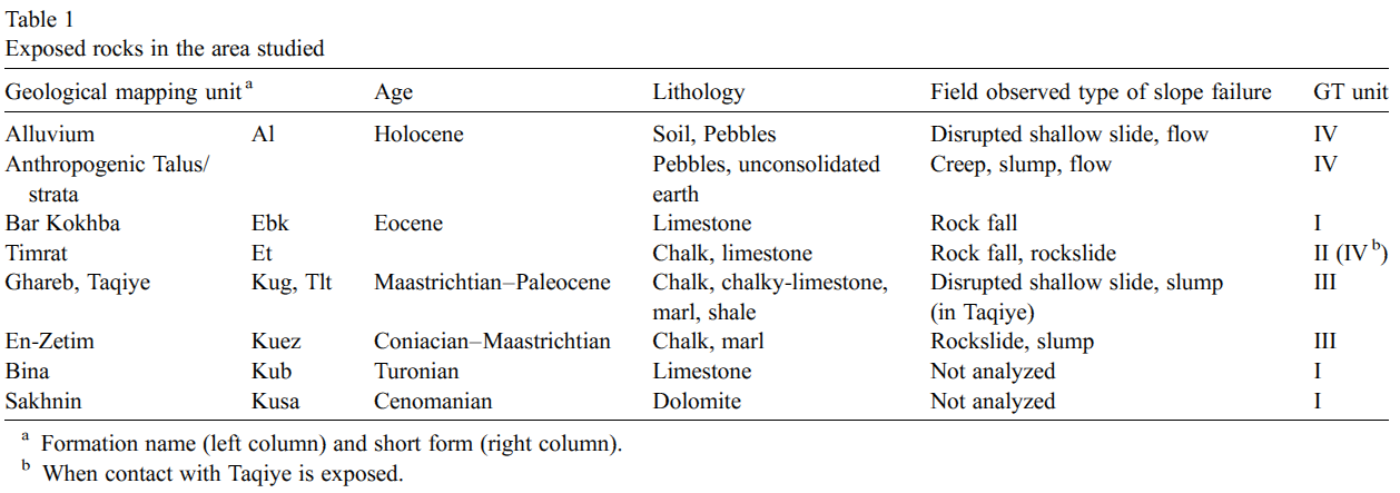 Table 1
Exposed rocks in the area studied
Katz and Crouvi (2007)
Katz and Crouvi (2007:62-63) used the 1:50,000 scale geologic map of Levitte (2001) and discussed the Geologic Setting as follows:
The bedrock under the lower parts of the core city is the chalky Coniacian–Maastrichtian En-Zetim Formation (Kuez) and chalky-limestone Maastrichtian Ghareb Formation (Kug). The bedrock under the upper parts of the core city is the Paleocene Taqiye Formation (Tlt), which consists primarily of marl and shale, and the Eocene Timrat Formation (Et), which consists of chalk and chalky-limestone (Levitte, 2001). Upper Cenomanian to Turonian limestone and dolomite of the Sakhnin (Kusa) and Bina (Kub) Formations outcrop in the core city at the foot of the western hill (Fig. 2a).
Nevertheless, in the frame of the current study we found that most of the core city is built on talus/strata of anthropogenic material up to 10 m thick that was unconformably deposited on top of this rock sequence in the course of the long 2000b years habitation (Fig. 2b, c). The anthropogenic material is typical of an archeological tell (Rosen, 1986) and in the studied area it exhibits two types: (1) talus-like: inclined (up to 30°) layers of pebbles and pottery embedded in unconsolidated, thin earth-like material (Fig. 3a); this type is exposed mainly around the citadel, and (2) ruins of man-made stone structures filled and covered by reworked sediments (Fig. 3b).
The majority of the new city (S and E of the Citadel) is built on the Eocene Timrat and Bar Kokhba (Ebk) Formations; the latter consists of limestone. The lowermost parts of the new city are built on the En-Zetim and the Ghareb Formations (Fig. 2a).
None of the faults mapped by Levitte (2001) in the area studied are considered active faults (Bartov et al., 2002). Thus, we believe that the damage reported from historical earthquakes in the area is not a consequence of surface rupture but of slope failure.
Katz and Crouvi (2007:61) applied a
relatively simple limit–equilibrium static model of an infinite slope in a material having both frictional and
cohesive strength to all the slopes studied
. They defined their Factor of Safety (FS) as follows:
FS = C/γtsinα + tanΦ/tanα
where
C = Cohesion
γ = Unit Weight
t = Slope normal thickness of the failure slab
α = Thrust angle
Φ = Angle of Internal Friction
For a planar slide, thrust angle (β) is the direction the COG of the sliding block moves when displacement initially occurs. Ideally this is the dip of the bedding plane. In regional studies this is typically approximated by the slope angle (Katz and Crouvi, 2007 citing Miles and Keefer, 2001). In their GIS analysis, Katz and Crouvi (2007:61)
- Newmark (1965)'s slope stability model
showing thrust angle (β)
O = Circle center
c.g. = Center of Gravity
β = Thrust angle
Newmark (1965)used this practice except for places (pixels) where rock slide is the most-likely slope failure typein which case they used bedding plane dip angle. Katz and Crouvi (2007:61) computed slope angle from the digital terrain model of Hall (1993) and the bedding plane angle from the structural map of Fleischer and Gafsou (2003).
- Earthquake Archeological
Effects from Rodríguez-Pascua et al (2013: 221-224)
 Earthquake Archeological
Effects Chart
Earthquake Archeological
Effects Chart
Click on image to open in a new tab
Rodríguez-Pascua et al (2013) - Environmental Effects (ESI 2007)
 Graphic Representation of
ESI 2007 Intensity
Graphic Representation of
ESI 2007 Intensity
Click on image to open in a new tab
- Synoptic Table of ESI 2007
Intensity Degrees from Michetti et al. (2007)
 Synoptic Table of ESI 2007
Intensity Degrees
Synoptic Table of ESI 2007
Intensity Degrees
Accuracy improves in higher degrees, especially VIII–XII.
Click on image to open in a new tab
Michetti et al. (2007) - Environmental Effects vs. Intensity
from Michetti et al. (2007)
 Diagnostic ranges for
environmental effects by intensity
Diagnostic ranges for
environmental effects by intensity
Click on image to open in a new tab
Michetti et al. (2007) - Simple MMI Intensity Scale
 Simple MMI Intensity
Scale
Simple MMI Intensity
Scale
Click on image to open in a new tab - More Subjective MMI Intensity Scale
 More Subjective MMI Scale
Click on image to open in a new tab

| Effect | Location | Image(s) | Description(s) | Intensity |
|---|---|---|---|---|
|
Safed |
|
|
|
|
Safed |
|
- Earthquake Archeological Effects chart
of Rodríguez-Pascua et al (2013: 221-224)
 Earthquake Archeological Effects (EAE)
Rodríguez-Pascua et al (2013: 221-224)
| Effect | Location | Image(s) | Description(s) | Intensity |
|---|---|---|---|---|
|
Safed |
|
|
|
|
Jewish Quarter of Safed |
|
|
|
|
Jewish Quarter of Safed |
|
|
|
|
|
|
||
| Collapse (Collapsed Walls) | The Castle |
|
VIII+ | |
| Landslide | Jewish Quarter on the western slope |
|
IV+ |
| Source | Image | Figure | Description |
|---|---|---|---|
| Katz and Crouvi (2007) |
Fig. 2a Geological map of the studied area (Levitte, 2001; anthropogenic material mapped in the frame of this work). The current Zefat city limits are marked by a blue solid line Katz and Crouvi (2007) |
Figure 2a | Geological Map of Area |
| Katz and Crouvi (2007) |
Fig. 2b The core (historical) city area. The core city extended from the Citadel, westwards to the old cemetery (α). Sites of field-observed slope instability are marked by black arrows. Also shown are upslope limits of EILS area in the 1759 and 1837 earthquakes (β and γ, respectively) according to reported damage to synagogues (marked by close squares where
Katz and Crouvi (2007) |
Figure 2b | Geological Map of Safed |
| Katz and Crouvi (2007) |
Fig. 2c West– East (A–A') geological cross section through the Citadel and the core city of Zefat; location is shown in a (the thickness of the anthropogenic talus is approximated). Katz and Crouvi (2007) |
Figure 2c | Geological cross section |
| Katz and Crouvi (2007) |
Fig. 2 Legend for Figure 2 a, b, and c Katz and Crouvi (2007) |
Figure 2 | Legend |
| Katz and Crouvi (2007) |
Table 1 Exposed rocks in the area studied Katz and Crouvi (2007) |
Table 1 | Exposed rocks |
| Katz and Crouvi (2007) |
 Fig. 3
Types of anthropogenic material typical of an archeological mound (‘tell’) outcrop in the core city of Zefat:
Katz and Crouvi (2007) |
Figure 3 | Anthropogenic material |
| Katz and Crouvi (2007) |
 Fig. 4a
Field evidence for instability of the anthropogenic material slopes: Inclined lamp posts found in the anthropogenic talus (marked by arrows) Katz and Crouvi (2007) |
Figure 4a | Inclined Lamp Posts |
| Katz and Crouvi (2007) |
 Fig. 4b
Field evidence for instability of the anthropogenic material slopes: open cracks (marked by arrows) in retaining wall founded in the anthropogenic talus Katz and Crouvi (2007) |
Figure 4b | Open cracks in retaining wall |
| Katz and Crouvi (2007) |
 Fig. 4c
Field evidence for instability of the anthropogenic material slopes: open cracks (marked by arrows) in building founded in the anthropogenic talus Katz and Crouvi (2007) |
Figure 4c | Open cracks in a building |
| Katz and Crouvi (2007) |
 Fig. 4d
Field evidence for instability of the anthropogenic material slopes: rainy winter-season slump in the anthropogenic talus. Katz and Crouvi (2007) |
Figure 4d | Winter-season slump in the anthropogenic talus |
| Katz and Crouvi (2007) |
 Table 2
Mechanical properties of the geotechnical units Katz and Crouvi (2007) |
Table 2 | Mechanical properties of the geotechnical units |
| Katz and Crouvi (2007) |
Fig. 5 Map of the geotechnical units in the area studied (for details see Tables 1 and 2). The core (old) city extends from the citadel (marked by a triangle) westwards toward the city limits. Katz and Crouvi (2007) |
Figure 5 | Geotechnical Map |
| Katz and Crouvi (2007) |
Fig. 5 Legend Legend for Figure 5 Katz and Crouvi (2007) |
Figure 5 Legend | Legend for Geotechnical Map |
| Katz and Crouvi (2007) |
Fig. 6 Map of calculated critical acceleration in the study area. The core (old) city extends from the citadel (marked by a triangle) westwards toward the city limits Katz and Crouvi (2007) |
Figure 6 | Critical Acceleration Map |
| Katz and Crouvi (2007) |
Fig. 6 Critical Acceleration Map Legend Katz and Crouvi (2007) |
Figure 6 Legend | Critical Acceleration Map Legend |
| Katz and Crouvi (2007) |
Fig. 7a Calculated Newmark displacement maps of two historical earthquakes used to calibrate the mechanical model, (a–b) October 1759 Mw = 6, R= 15 earthquake Katz and Crouvi (2007) |
Figure 7a | Newmark displacement map for 1759 Safed Quake |
| Katz and Crouvi (2007) |
Fig. 7b Calculated Newmark displacement maps of two historical earthquakes used to calibrate the mechanical model, (a–b) October 1759 Mw = 6, R= 15 earthquake. For inferred location of epicenter see text and Fig. 1. Also shown are upslope limits of EILS area in the 1759 and 1837 earthquakes ( β and γ, respectively, see Fig. 2) traced according to reported damage to synagogues (marked by numbered close squares, see Fig. 2). Katz and Crouvi (2007) |
Figure 7b | Newmark displacement map for 1759 Safed Quake |
| Katz and Crouvi (2007) |
Fig. 7c Calculated Newmark displacement maps of two historical earthquakes used to calibrate the mechanical model, (c–d) January 1837 Mw = 7, R= 10 earthquake. For inferred location of epicenter see text and Fig. 1. Also shown are upslope limits of EILS area in the 1759 and 1837 earthquakes ( β and γ, respectively, see Fig. 2) traced according to reported damage to synagogues (marked by numbered close squares, see Fig. 2). Katz and Crouvi (2007) |
Figure 7c | Newmark displacement map for 1837 Safed Quake |
| Katz and Crouvi (2007) |
Fig. 7d Calculated Newmark displacement maps of two historical earthquakes used to calibrate the mechanical model, (c–d) January 1837 Mw = 7, R= 10 earthquake. For inferred location of epicenter see text and Fig. 1. Also shown are upslope limits of EILS area in the 1759 and 1837 earthquakes ( β and γ, respectively, see Fig. 2) traced according to reported damage to synagogues (marked by numbered close squares, see Fig. 2). Katz and Crouvi (2007) |
Figure 7d | Newmark displacement map for 1837 Safed Quake |
| Katz and Crouvi (2007) |
 Fig. 8
Maximal fault zone distance (R, km) for EILS (threshold DN values are 5–10 cm or 10 cm<, for the more and less conservative cases, respectively) as a function of the triggering earthquake magnitude (MW). Data is from the calculated scenario earthquakes (for location see Fig. 1). Also plotted are the maximal fault zone distances for EILS according to Keefer (1984). Katz and Crouvi (2007) |
Figure 8 | Fault Distance vs. Magnitude Plot |
| Katz and Crouvi (2007) |
Fig. 9a Examples of calculated Newmark displacement maps (EILS hazard) in scenario earthquakes.
Katz and Crouvi (2007) |
Figure 9a | Newmark displacement map for MW = 6 earthquake |
| Katz and Crouvi (2007) |
Fig. 9b Examples of calculated Newmark displacement maps (EILS hazard) in scenario earthquakes.
Katz and Crouvi (2007) |
Figure 9b | Newmark displacement map for MW = 7 earthquake |
| Katz and Crouvi (2007) |
 Fig. 10
Engineering status in the core city of Zefat: past and present building codes. Old buildings (built no later than about mid 20th century) are typically founded on the anthropogenic talus and are not supported by the underlying bedrock. For the construction of some of the newer buildings the anthropogenic talus was dug out and the structure was founded on the bedrock. In addition, piles and rock-bolts were placed to reinforce the slope cut behind the house. Katz and Crouvi (2007) |
Figure 10 | Engineering status in the core city of Safed |