Purkis et al. (2022a) identified evidence for a geologically recent submarine slope failure in the Straits of Tiran, where the Gulf of Aqaba opens into the Red Sea. The feature is located on the steep eastern margin of the Straits, above the Tiran Deep and close to the Tiran fault. The approximately 6 km-long scarp begins at about 90 m water depth on a slope that descends at more than 30° toward the approximately 1200 m-deep Tiran Deep. The scarp averages about 8 m in height, locally reaches approximately 15 m, and displays both vertical and lateral displacement. Two older, complete slope failures occur less than 5 km to the north, demonstrating that this part of the margin has repeatedly undergone submarine collapse.
The scarp is interpreted as the headwall of an incipient submarine landslide in which a large mass of sediment began moving downslope but stalled after a relatively short displacement. Sparse and low-diversity coral colonization of the exposed scarp, together with statistically similar coral community densities on its upper and lower portions, indicates that the scarp formed rapidly during a single geologically recent event rather than progressively over a long period. Radiometric dating further indicates that this event occurred during the last several centuries. Coral skeletons incorporated into the former seabed range from 2888 to 1558 yr BP, whereas lithified sediments infilling the coral framework produced younger calibrated 14C ages ranging from 884-1762 CE (1066 to 188 yr BP). Purkis et al. (2022a:4) suggests that the three youngest ages from samples 1, 2, and 3 were taken from material of the same age and likely date the event. Calibrated dates for these three samples are 334 ± 146, 436 ± 134, and 536 ± 114 yrs BP which equates to 1300-1762 CE (188 to 650 yr BP). While Purkis et al. (2022a) suggested that the slope failure occurred approximately 400-500 years ago (1450-1550 CE), a crude 1σ time range miight span from ~1400 to ~1650 CE.
Numerical modeling by Purkis et al. (2022a) indicates that only a modest amount of downslope movement was required to generate a substantial tsunami. In their modeled incipient failure, the slide moved approximately 35 m horizontally and 12 m vertically in about 9 seconds, reaching a maximum velocity of 7.3 m/s. Despite this limited displacement, the modeled tsunami produced a wave approximately 6 m high at Sharm El Sheikh after about 1 minute 30 seconds and waves approaching 10 m at Mousa Bay, just north of Sharm El Sheikh, and portions of the Saudi Arabian coast within several minutes. The unusually large response reflects the narrow geometry of the Straits of Tiran, where tsunami waves have little distance in which to attenuate before reaching the opposite shoreline.
Purkis et al. (2022a) originally discussed the event as a submarine slope failure whose tsunami may not have been associated with an earthquake. That interpretation has subsequently been revised by the lead author. In personal correspondence with Jefferson Williams in 2026, Sam Purkis stated that he now considers the feature to record “a major seismic event and tsunami around 1588 CE.” The scarp and associated submarine mass movement are therefore interpreted here as possible evidence for a seismically triggered slope failure and tsunami associated with the 1588 CE Earthquake(s).
Independent evidence for this event may be present in numerous R/V Thuwal cores from the Gulf of Aqaba. Bektaş et al. (2024:12) report that “numerous coeval turbidites” were identified in R/V Thuwal cores. Based on Probability Density Functions (PDFs) presented in Fig. 8 of their paper, these deposits were likely emplaced between ~1500 and ~1600 CE ( 1σ) and were interpreted as most probably associated with the 1588 CE Earthquake. Kanari et al. (2020) also suggested that the 1458 CE earthquake or the 1588 CE earthquake was responsible for Event E2 in Trench T3 from the Elat Sabkha Trenches
- Fig. 1 Location map from
Purkis et al. (2022a)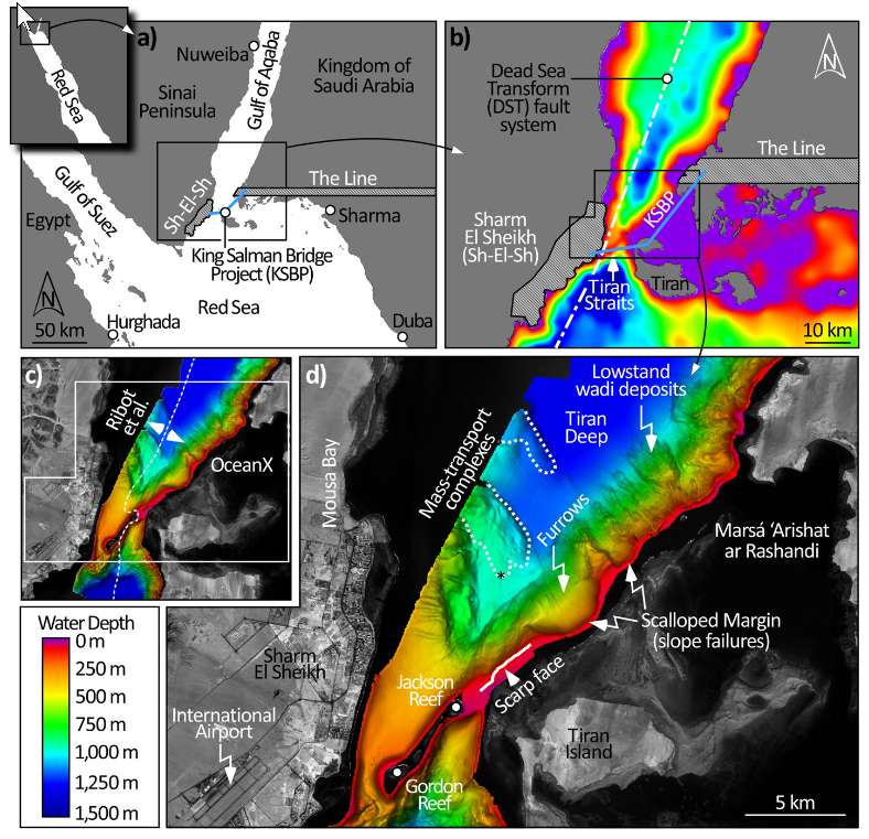
Fig. 1
Location of the study area in the Tiran Straits, tectonic setting, and bathymetry:
- The strike-slip Dead Sea Transform (DST) fault system (white dot-dash line in b) runs along the axis of the Straits and is composed of several systematically offset, overlapping, left-lateral transform faults. Local infrastructure includes the Egyptian town of Sharm El Sheikh (approx. city limits, hatched polygon in a and b), and planned construction of “The Line,” a 170 km-long east-west-trending city (hatched rectangle in b), and the King Salman Bridge Project which would straddle Tiran Island (blue line in a-b, position approximate).
- Multibeam bathymetry created by merging data from Ribot et al. (2021), west of the broken white line in (c), with that acquired by OceanX (east of broken white line).
- Enlarges the bathymetry offshore Sharm El Sheikh including the location of the scarp face and two instances of slope failure to the north of it, recognized by the paired occurrences of scallop “bite” marks in the eastern margin of the Straits with mass-transport complexes (delimited by broken white lines) lying outboard of them on the abyssal plain of the Tiran Deep. Submersible dive (black asterisk) on the southernmost complex confirmed abundant breccia blocks. Margin-perpendicular furrows are evident on areas of the slope that have failed, likely excavated by cascading density currents. To the northeast of the two paleo-slope failures, canyon heads at the shelf break have been fed by wadis during sea-level lowstands, delivering substantial deposits to the abyssal plain.
Click on image to open in a new tab
Purkis et al. (2022a)- Fig. 2D and 3D Scarp maps from
Purkis et al. (2022a)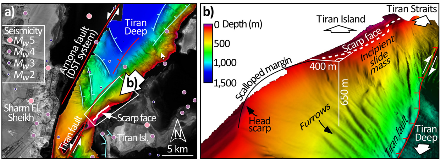
Fig. 2
Seismotectonic setting of the Tiran Straits and southern Gulf of Aqaba:
- Shows the main active faults in the vicinity of the Straits (modified from Goldberg & Beyth, 1991 and from Ribot et al., 2021) and Mw ≥ 2 earthquakes for the period 1970–2021 (U.S. Geological Survey). Strike-slip faults are in red. Both the Tiran and Arnona faults are part of the strike-slip Dead Sea Transform (DST) fault system (Figure 1b). Normal faults are in cyan. The area in the white polygon is shown in three dimensions in (b).
- Here, vertical exaggeration is ×2.5 and the observer is looking from the northeast, along the Saudi margin of the Gulf of Aqaba, toward the Straits. The scarp face (broken white line) situates immediately adjacent to a scallop which demarks a previous margin failure. We interpret the slide mass from the incipient failure which generated the scarp to extend down-slope to a water depth of 650 m. The toe-of-slope beneath this mass is at 850 m depth and bounded by the Tiran fault.
Click on image to open in a new tab
Purkis et al. (2022a)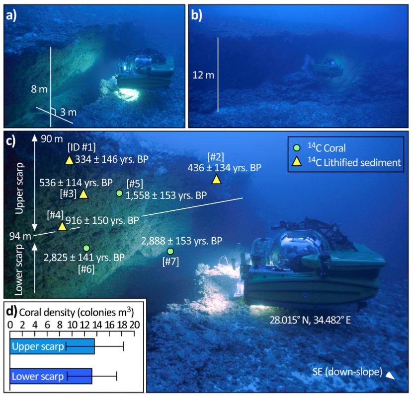
Fig. 3
Radiocarbon dates and distribution of biota on the scarp face:
- Representative photograph of the scarp. The sub is facing southeast, into the scarp, toward Tiran Island. The abyssal depths of the Tiran Deep are therefore aft of the sub in this photograph. The scarp has both a vertical and lateral offset, which at this location measures 8 and 3 m, respectively.
- Representative photograph of the scarp acquired ∼50 m back from the scarp. The sub is facing southeast, into the scarp, toward Tiran Island. The abyssal depths of the Tiran Deep are therefore aft of the sub. The vertical offset here attains 12 m, approaching the maximum vertical offset of 15 m encountered along the 6 km strike of the feature.
- Either corals, or the (now lithified) sediments infilling their skeletons, were isolated from each rock sample extracted from the scarp and 14C dated. Ages calibrated to calendar years BP (before present) with 2 sigma error reported. Sample IDs in square brackets reference Table S1 in Supporting Information S1. Corals range in age from 2,888 years to 1,558 years BP. Lithified sediments are younger, ranging from 916 years to 334 years BP. White line divides the scarp into upper (90–94 m water depth) and lower (94–98 m) units where mean density (±std) of coral colonies was quantified (d).
- The densities are not significantly different (p > 0.05), implying the scarp was created swiftly by a single event.
Click on image to open in a new tab
Purkis et al. (2022a)