Open this page in a new tab

Sister's School Trench

Figure 5.8

Cross-section of both the north and south Taba Sabkha trench walls showing faulting, stratigraphic offset, and radiocarbon dates of charcoal samples collected.

click on image to open in a new tab

Allison (2013)


Maps, Aerial Views, Trench Log, Stratigraphic Column, Rose Diagram, Dating Table, and Photos

Maps and Aerial Views

Normal Size

  • Fig. 1.2 Location map from Allison (2013)
  • Fig. 4.1 Location map from Allison (2013)
  • Fig. 5.1 Location map from Allison (2013)
  • Fig. 5.2 Location map from Allison (2013)
  • Fig. 5.3 Location map from Allison (2013)
  • Fig. 5.4 Site plan from Allison (2013)
  • Fig. 5.15 Fault Map around trench site from Allison (2013)

Magnified

  • Fig. 1.2 Location map from Allison (2013)
  • Fig. 4.1 Location map from Allison (2013)
  • Fig. 5.1 Location map from Allison (2013)
  • Fig. 5.2 Location map from Allison (2013)
  • Fig. 5.3 Location map from Allison (2013)
  • Fig. 5.4 Site plan from Allison (2013)
  • Fig. 5.15 Fault Map around trench site from Allison (2013)

Trench Log

Location Map

Location Map

Figure 5.3

Location map of Sisters’ School trench within the city of Aqaba, Jordan. The building foundation trench is outlined in black and the arrow points toward the southwest wall which contains the majority of faults identified at the site. Topographic contour lines, trending generally NW-SE, are shown with a 1 m contour interval.

click on image to open in a new tab

Allison (2013)


Site Plan

Figure 5.4

Top plan map of the Sisters’ School trench within the city of Aqaba, Jordan. The building foundation trench is outlined in black, and a red arrow points toward the southwest wall that contains approximately half of all the faults identified at the site. Faults and dikes identified in the trench walls are marked with either a short black line or a red strike and dip symbol where available and where space would allow. Fault lines in black are drawn perpendicular to their respective trench wall for uniformity and do not indicate direction of strike.

click on image to open in a new tab

Allison (2013)


Trench Logs

Trench Log

Figure 5.8

Cross-section of both the north and south Taba Sabkha trench walls showing faulting, stratigraphic offset, and radiocarbon dates of charcoal samples collected.

click on image to open in a new tab

Allison (2013)


Clastic Sand Dike

Figure 5.10

Clastic sand dike SD-1 and associated EQ I (MRE) fault located in the southwest wall of the Sisters’ School trench. The dike is 2.5-6 cm wide in cross-section and reaches approximately 3.8 m above the ground surface of the trench floor.

click on image to open in a new tab

Allison (2013)


Stratigraphic Column

Figure 5.9

Paleoseismic faulting and a generalized stratigraphic section of the Sisters’ School southwest trench wall in Aqaba, Jordan. Colored stratigraphic units correlate to the colored cross-section of the SW trench wall (see Figure 5.8).

click on image to open in a new tab

Allison (2013)


Rose Diagram

Site Plan

Figure 5.4

Top plan map of the Sisters’ School trench within the city of Aqaba, Jordan. The building foundation trench is outlined in black, and a red arrow points toward the southwest wall that contains approximately half of all the faults identified at the site. Faults and dikes identified in the trench walls are marked with either a short black line or a red strike and dip symbol where available and where space would allow. Fault lines in black are drawn perpendicular to their respective trench wall for uniformity and do not indicate direction of strike.

click on image to open in a new tab

Allison (2013)


Rose Diagram

Figure 5.14

Rose diagram depicting the direction of strike as measured from twentyfive paleoseismic faults identified within the Sisters’ School trench. Locations of faults providing strike and dip measurements are mapped on the site top plan (see Figure 5.4).

click on image to open in a new tab

Allison (2013)


Dating Table

OSL and Radiocarbon Dating Results

Table 5.1

Geochronology Of Sisters’ School Trench, Aqaba, Jordan

Optically Stimulated Luminescence (Osl) Dating Results And Radiocarbon Dating Results

Click on image to open in a new tab

Allison (2013)


Photos

Normal Size

  • Fig. 5.6 Fire pit exposed in cross-section in the south wall of the Sisters’ School trench from Allison (2013)
  • Fig. 5.7 Closeup of Fire pit from Allison (2013)
  • Fig. 5.11 Clastic sand dike SD-1 located in meter 21 of the southwest wall of the Sisters’ School trench from Allison (2013)
  • Fig. 5.10 Clastic sand dike SD-1 trench log from Allison (2013)
  • Fig. 5.12 Clastic sand dike closeup from Allison (2013)
  • Fig. 5.13 Clastic sand dikes SD-2 and SD-3 located in meter 16 of the southwest wall of the Sisters’ School trench from Allison (2013)

Magnified

  • Fig. 5.6 Fire pit exposed in cross-section in the south wall of the Sisters’ School trench from Allison (2013)
  • Fig. 5.7 Closeup of Fire pit from Allison (2013)
  • Fig. 5.11 Clastic sand dike SD-1 located in meter 21 of the southwest wall of the Sisters’ School trench from Allison (2013)
  • Fig. 5.10 Clastic sand dike SD-1 trench log from Allison (2013)
  • Fig. 5.12 Clastic sand dike closeup from Allison (2013)
  • Fig. 5.13 Clastic sand dikes SD-2 and SD-3 located in meter 16 of the southwest wall of the Sisters’ School trench from Allison (2013)

Paleoseismic Chronology
EQ V - between 6600 and 4840 BCE

Discussion

Discussion

References
Allison (2013)

Chapter 5 Sisters’ School Trench

Introduction and Motivation for Research

The second paleoseismology study conducted as part of this dissertation research consisted of a geological survey of the Aqaba region in Jordan to locate and identify exposed segments of the Dead Sea transform fault. With construction and growth within the city of Aqaba at an all-time high, there were many newly opened building foundation trenches present at the time of this study in 2009 and 2010. With the permission of the onsite construction crews, several of these trenches were examined in search of evidence of earthquake faulting. Open foundation trenches dug for the construction of a new building are large exposures that typically contain numerous cuts into the earth at various angles, allowing for a quick assessment of whether a particular tract of land contains fault strands of the Dead Sea transform. Digging trenches in search of earthquake faulting is a time-consuming and expensive process, and as discussed in an earlier chapter, within the city of Aqaba this is becoming increasingly problematic as a result of intense urbanization (Rucker and Niemi, 2005). By being allowed to examine numerous foundation trenches and exposures, it was possible to more quickly narrow down locations where the Dead Sea transform has ruptured in the past, as well as where it has not.

While several foundation trenches were examined, earthquake faulting was identified in only one trench during the course of this study. At a site referred to herein as the Sisters’ School site, multiple earthquake faults were identified in the foundation trench walls, along with evidence of paleoliquefaction in the form of clastic sand and silt dikes. At the time of this survey, this trench had apparently been abandoned by the construction crew, perhaps due to the large number of faults present at the site, or perhaps because funding for the construction project had been exhausted. In the absence of any construction crew or landowner at the site, the Department of Antiquities of Jordan granted the Wadi ‘Arabah Earthquake Project permission to conduct a paleoseismic survey within the Sisters’ School trench, since this geologic study was non-invasive in nature.

Understanding exactly where and how often the Dead Sea transform has ruptured in the historic past within the now densely populated city of Aqaba is of the utmost importance for seismic hazard analysis and building code development. Even though the Dead Sea transform is seismically active, and the city of Aqaba is built directly along this major tectonic boundary, it remains difficult to identify exactly where the faults are located within the city. As discussed in Chapter 3, the exact location where the Aqaba fault comes onto land is still unknown. Modern buildings, asphalt roads, and landscaping hide the seismic scars of the past, temporarily burying them from view. Thus, the motivation for this study is to further elucidate these faults within the city of Aqaba, determine the last time they ruptured and how often they tend to do so, and increase awareness of this active seismic zone among city officials and planners. Dating the faults exposed at the Sisters’ School site is also important for understanding the history and chronology of earthquake faulting in the greater southern Wadi ‘Arabah region.

Local Setting of Aqaba, Jordan

Located in the far southwestern corner of Jordan, the city of Aqaba lies approximately 320 km south of the capital city of Amman and is situated at the head of the Gulf of Aqaba/Eilat. Aqaba lies within the geographic coordinates of 29˚30'–29˚40' N and 34˚59'–35˚03' E, and is influenced by a relatively wet Mediterranean climate to the northwest, and a hot, arid climate to the south and east. As described in a previous chapter, Jordan typically has a short rainy winter, while the remainder of the year is warm and dry with temperatures often exceeding 40º C in the summer months. According to data from the Aqaba Meteorological Station (1955-2002), the average annual rainfall in Aqaba is less than 50 mm, yet despite the aridity there is a large freshwater aquifer only a few meters beneath the surface.

There are several drainage basins in the Aqaba region, but the largest drainage basin in the southern ‘Arabah Valley is Wadi Yutim which reaches the furthest into the eastern plateau and covers over 4,545 km2 (Foote et al., 2011). There are also several branches of the Wadi Yutim drainage basin that flow to the south toward the Gulf of Aqaba. Niemi and Smith (1999) mapped the alluvial fans of Aqaba and of the Wadi ‘Arabah and identified three cycles of fan alluviation, entrenchment, and soil development. The two Holocene-aged fan progradations mapped as a part of this study correlate well with the archaeological record at 6 ka and 2-3 ka (Niemi and Smith, 1999).

Geological studies of the Aqaba area conducted by Mansoor (2002) and Slater and Niemi (2003) show the so-called "Aqaba fault" emerging from the Gulf of Aqaba on the far eastern side of the Gulf head and trending northeast underneath the city. The Aqaba fault borders the Gulf's east side in Jordan and dies out under the city of Aqaba where it is currently covered by rapidly growing urban development. Offshore, high-resolution geophysical surveys conducted by Tibor et al. (2010) and Hartman (2012) also mapped several segments of the DST that are present within the Gulf of Aqaba (Figure 5.1). From the known location of the Aqaba fault, the DST steps west approximately 0.5 km to the West Aqaba fault. In the middle of the Gulf, the East Ayla fault and the Ayla fault are truncated by the Holocene surface suggesting they are not active (Hartman, 2012). The segments of the Dead Sea transform on the Israeli side of the Gulf of Aqaba include the Evrona fault (or Wadi ‘Arabah fault as it is called on the Jordanian side) along northwest-striking, normal-to-oblique slip faults (e.g. Amit et al., 1999), and the Eilat fault located on the far western side of the head of the Gulf (Hartman, 2012). The goal of this research is to further elucidate the various segments of the Dead Sea transform beneath the city of Aqaba, which will ultimately act to improve the earthquake catalogs for the region.

Paleoseismic Investigation of the Sisters’ School Trench

Methodology

Introduction

The geological investigation for this study was conducted over the course of three field seasons in 2009 and 2010. The Sisters’ School site is so named because it is located adjacent to the Rosary Sisters’ School, an elementary school situated within the city of Aqaba, Jordan. This site is located approximately 1 km northeast of the head of the Gulf of Aqaba and approximately 1.3 km north of the archaeological site of Early Islamic Ayla (Figure 5.2). Each wall in the approximately 140 m by 100 m Sisters’ School trench was evaluated for faulting evidence using seismic indicators such as vertically offset stratigraphic units, units that mismatch abruptly across a fault line, the presence of sand-filled fissures, and evidence of paleoliquefaction in the form of clastic dikes. The majority of faults present at this site were concentrated along the southern end of the trench, with half of these faults concentrated within only the southwest wall. Due to the sheer size of the site, the southwest wall became the primary trench wall of focus for this paleoseismic study (Figure 5.3), although all visible faults exposed in the trench were mapped and photographed,.

In order to study the exposed faults at the Sisters’ School site systematically, a grid system was first laid out on the southwestern wall of the site, and nails labeled both alphabetically and numerically were positioned at one-meter intervals horizontally and at half-meter intervals vertically. The main SW trench wall mapped at the site measures 27 meters in length and varies in height between 5 and 6 meters. This trench wall was first mapped in detail using photomosaic trench logging techniques (McCalpin, 2009). Each individual digital photograph was photo-rectified to remove any angle distortion present before being digitally stitched together to create a photomosaic of the trench wall. Trench log linework including stratigraphic units, contacts, and fault lines were described and drawn on top of the corrected photomosaic image in the field. Stratigraphic units were differentiated and described on the basis of grain size, sorting, lithology, type of boundary, degree of cohesion, structure, and color as determined from a Munsell® soil chart.

Although the southwest wall was mapped in the greatest detail, all faults and fractures in the exposed trench walls were mapped in an effort to better understand the seismicity of the region. A top plan of the entire site was also drawn to scale (Figure 5.4). The fault terminations and sedimentary units that could not be reached from the ground or by using a ladder were photographed and mapped using a “bucket truck” which allowed the stratigraphic units located highest up on the wall to be reached. All arrangements to use this equipment, as well as all other logistical support required to work at this site, was facilitated by Dr. Sawsan Fakhri of the Department of Antiquities in Aqaba. Her assistance was paramount to the geological research success at this site.

Figure 5.4

Top plan map of the Sisters’ School trench within the city of Aqaba, Jordan. The building foundation trench is outlined in black, and a red arrow points toward the southwest wall that contains approximately half of all the faults identified at the site. Faults and dikes identified in the trench walls are marked with either a short black line or a red strike and dip symbol where available and where space would allow. Fault lines in black are drawn perpendicular to their respective trench wall for uniformity and do not indicate direction of strike.

click on image to open in a new tab

Allison (2013)


Optically Stimulated Luminescence Dating

The Sisters’ School site contains very little organic matter suitable for radiocarbon dating purposes. Therefore, in an effort to date the seismic events present in the Sisters’ School trench, sediment samples were collected from within relevant stratigraphic horizons to be dated using optically stimulated luminescence (OSL). OSL is a dating technique useful for establishing the depositional age of sediments, and thus for determining the age of a capping stratigraphic unit, in the absence of datable organic material. OSL dating is a form of geochronology that measures the energy of photons being released from individual silicate mineral grains, primarily quartz and potassium feldspar (Aitken, 1998). As sediment is transported by wind, water, or ice, it is exposed to sunlight, bleached, and zeroed of any previous luminescence signal. Once this sediment is deposited and subsequently buried, it ceases being exposed to sunlight and is exposed to low levels of natural radiation (U, Th, Rb) in the surrounding sediment (Aitken, 1998). Through geologic time, quartz and feldspar minerals accumulate a luminescence signal as ionizing radiation excites the electrons within parent nuclei in the mineral grain’s crystal lattice. A certain percentage of the freed electrons become trapped in defects or holes in the crystal lattice and accumulate over time (Aitken, 1998). This stored radiation dose can be “evicted” with stimulation and released as luminescence. The calculated age of an OSL date is the time since the last exposure of that sediment to sunlight. As time passes, the luminescence signal increases through exposure to ionizing radiation and cosmic rays. Luminescence dating is based on quantifying both the radiation dose received by a sample since its zeroing event, and the dose rate it has experienced during the accumulation period after deposition.

OSL samples are light-sensitive and must be collected in a dark, controlled environment. In order to ensure that sediment samples were not contaminated by sunlight exposure during collection, samples were carefully collected from beneath layers of dark sheets using a 20 cm-long and 7 cm-wide PVC tube cut to length (Figure 5.5). Once the protective sheets were hung over the area to be sampled, the sediment was cleaned back approximately 5-6 cm into the trench wall. The PVC tube was then hammered into the specific stratigraphic unit to be sampled, forcing sediment into the sample tube. Lastly, layers of duct tape were placed over each end of the tube before being removed from beneath the protective cover.

In the lab, the portion of each sediment sample used for OSL dating purposes was collected from the center of the tube in a darkroom environment by Dr. Naomi Porat at the Geological Survey of Israel in Jerusalem. Quartz samples (88-125 µm) were etched by soaking in concentrated hydrofluoric acid for forty minutes. The De value, or equivalent dose, was obtained using the single aliquot regeneration (SAR) dose protocol, using preheats of 10 seconds at 220-260 ˚C. The moisture content of each sample collected from the site was estimated at 2%. At first, thirteen 5 mm aliquots were measured for samples SS-1 through SS-5. Aliquots, as far as OSL dating is concerned, are the portion of a sediment sample taken or collected for analysis. All samples had a typical fluvial dose distribution, with some of the older aliquots indicating incomplete bleaching of the quartz grains. The more scattered samples, SS-2, SS-4, and SS-5, were measured again using twenty-four 2 mm aliquots to isolate the younger population of sediment grains. For those samples, the 5 mm aliquots were not used in age calculations. Samples SS-6 and SS-8 were measured at first using 3 mm aliquots. Sample SS-6 had a clear population containing 60% aliquots, and this was used for age calculation. Sample SS-8 had ages that measured as high as 17 ka, indicating that the measured sample contained both old and unbleached grains. In this case, the youngest age population was used. Currently, seven OSL samples have been dated and are reported in Table 5.1.

Table 5.1

Geochronology Of Sisters’ School Trench, Aqaba, Jordan

Optically Stimulated Luminescence (Osl) Dating Results And Radiocarbon Dating Results

Click on image to open in a new tab

Allison (2013)


Radiocarbon Dating

An ashy sediment sample containing fragments of charcoal, sample RC-SS #1, was collected from a fire pit exposed in cross-section in the south trench wall (Figures 5.6 and 5.7) for radiocarbon analyses by the Center for Accelerator Mass Spectrometry (CAMS) at the Lawrence Livermore National Laboratory in California. This single radiocarbon date was calibrated to a two sigma probability using the CALIB Radiocarbon Calibration 7.0 program and included the IntCal13 curve selection (Reimer et al., 2013). This radiocarbon date is reported in Table 5.1.

Table 5.1

Geochronology Of Sisters’ School Trench, Aqaba, Jordan

Optically Stimulated Luminescence (Osl) Dating Results And Radiocarbon Dating Results

Click on image to open in a new tab

Allison (2013)


Results

Sedimentological and Faulting Sequence of Sisters’ School Deposits

Paleoseismic events in the Sisters’ School trench were identified on the basis of primary coseismic evidence including upward-terminating faults, fissures, offset stratigraphic units, and offset channel deposits identified in the trench wall exposures (e.g. McCalpin and Nelson, 2009) (Figure 5.8). The stratigraphic expression of primary post-seismic evidence at this site consisted of a fissure fill present in meter 1 and 2 of the southwest trench wall where a fault ruptured the ground surface. An examination and analysis of the trench stratigraphy suggests that the Sisters’ School trench walls preserve evidence for at least five separate faulting events. The identified paleoseismic events are numbered sequentially with EQ I being the most recent event (MRE) exposed within the Sisters’ School trench and EQ V the oldest.

The lower stratigraphic sequence at the Sisters’ School site (Figure 5.9) consists primarily of interbedded fine- to medium-grained units of sand and silt that were washed down the Wadi ‘Yutim basin from distal alluvial fan runoff originating from the Precambrian granitic mountains located to the northeast and east of the study site. The upper stratigraphic units at the site are much more coarse-grained in nature. They largely consist of upward-fining sequences of fluvial deposits composed of cobbles, pebbles, granules, coarse-, medium-, and in places fine-grained sands. Also present in the trench stratigraphy are numerous smaller channel deposits of medium- to coarse-grained sands and pebbles with some cobbles. The presence of channels and larger fluvial deposits in the upper section of the trench wall indicates that both small to substantial flooding events occurred periodically at this location in the past.

At a depth of 5.5 m, the basal sedimentary units in the Sisters’ School trench include alternating beds of tan to tannish-brown, fine- to medium-grained sand, silt, and silty sand (units SS-24, SS-22, SS-18), a unit of light brown silty clay (SS-23), and units of tannish-brown sandy silt or clayey silt (units SS-19, SS-17). Unit SS-23 has a particularly hard compaction and has been interpreted as a possible paleosol. The oldest of the faulting events identified at the Sisters’ School site, EQ V, ruptures as high as unit SS-22 in the southwest wall and is capped by unit SS-19. Unit SS-16, a bed of tan, medium-grained sand, then caps all of these basal units, but is only present toward the eastern side of the southwest trench wall. Situated stratigraphically above unit SS-16 is unit SS-15, a tan, poorly sorted, medium- to coarse-grained sand containing gravel in places. Unit SS-15 contains a lens of fine-grained sand, unit SS-14, and two small channels, units SS-13 and SS-12. Channels SS-13 and SS-12 contain coarse-grained sand and pebbles, and SS-13 also contains a few cobbles. After deposition, all of these lower stratigraphic units, SS-24 through SS-15, were faulted by EQ IV. Faulting evidence for both EQ V and EQ IV includes vertically offset stratigraphic units, mismatched unit thicknesses across fault lines due to strike-slip motion, and upward fault terminations.

Unit SS-11 is a tan, fine-grained silty sand present in the eastern half of the southwest trench wall but pinches out at the boundary between meter 13 and 14. This sand caps EQ IV faults on the eastern end of the trench wall
. This layer is then overlain by unit SS-10, a tan, fine- to medium-grained ashy sand that contains concentrated lenses of ashy silt throughout. This stratigraphic layer also contains numerous worm burrows, and a small channel (SS-9) with pebbles and coarse-grained sand runs through the center of this layer around meters 8-9 in the trench wall. Unit SS-10 is interpreted as an “anthropogenic layer” because it contains a visible component of ash across the length of its exposure, presumably deposited from camp or cooking fires built in antiquity. Unit SS-10 can also be traced further to the east, past the edge of the southwest trench wall, to the south trench wall at the Sisters’ School site. At a depth of approximately 3.5 m from the ground surface, a clearly defined fire pit is exposed in cross-section within unit SS-10 (see Figures 5.6 and 5.7), helping to explain the abundance of ash in this layer. The upper boundary of unit SS-10, as can be seen on the trench cross-section (Figure 5.8), is interpreted as a possible archaeological surface. A charcoal sample collected from the fire pit was radiocarbon dated and will be discussed in an upcoming section.

All EQ III faults terminate within the lower to middle portion of unit SS-10, the anthropogenic layer, which is capped by unit SS-7, a light-brown, medium-grained sand, likely aeolian in nature. Layer SS-7 is cut by cobble-rich channels and either pinches out naturally or was scoured away on the western end of the trench wall starting in meters 18 and 19. Stratigraphically situated above these finer-grained deposits, unit SS-5 is an upward-fining, graded bed of rounded and sub-rounded cobbles, pebbles, coarse-, medium-, and fine-grained sands. This layer is more than a meter thick in places, particularly toward the western end of the trench wall, and thins to the east. All EQ II faults terminate at the contact between unit SS-7 and the overlying fluvial unit SS-5. It appears that a portion of unit SS-7 was scoured away during the higher-energy depositional phase of unit SS-5, along with the upper fault terminations of EQ II, because the faults now abruptly stop at the SS-7/SS-5 contact.

Overlying unit SS-5, layer SS-4 is also an upward-fining, graded bed of rounded and sub-rounded cobbles, pebbles, and coarse- to medium-grained sands, but it does not contain any fine-grained sand. Unit SS-3 is very similar to unit SS-5 and consists of an upward-fining, graded bed of rounded and sub-rounded cobbles, pebbles, coarse-, medium-, and fine-grained sands. Most MRE (most recent event) or EQ I faults, six in all, terminate within stratigraphic unit SS-3. The one exception is the fault found in meter 14 in the southwest wall that cuts into the lower portion of unit SS-4 and terminates at a depth of approximately 1.5 m from the top of the trench wall. This fault is either an EQ I fault that did not rupture as close to the ground surface as all of the other MRE faults, or it represents a different faulting event altogether that is represented nowhere else in the Sisters’ School southwest trench wall. This fault cannot be categorized as an EQ II fault as previously described because it cuts much higher than the EQ II terminations, which appear to have been partially scoured away by the deposition of unit SS-5 over unit SS-7.

Units SS-5, SS-4, and SS-3 are clearly fluvial in nature based on their upward-fining depositional sequence and because they are composed of individual clasts ranging in size from large cobbles to fine-grained sand. Together these units represent a significant change in the type of deposition for this coastal region in antiquity. Unit SS-2, a tan, medium-grained sand approximately 0.5 m thick, overlies this fluvial sequence and is likely aeolian. Layer SS-2 caps all EQ I (MRE) faults and is the oldest unit not faulted in the southwest trench wall. Finally, overlying SS-2 is unit SS-1, the uppermost stratigraphic unit exposed in the southwest trench wall at the Sisters’ School site. Layer SS-1 is another fluvial deposit of upward-fining, rounded and sub-rounded cobbles, pebbles, and coarse- to medium-grained sands.

Paleoliquefaction Evidence

Seven clastic dikes were identified in the stratigraphy of the Sisters’ School trench walls and are interpreted as evidence of paleoliquefaction. As discussed in an earlier chapter, liquefaction is a process by which unconsolidated sediments temporarily behave as a liquid as groundwater rises to the surface because of an increase in pore pressure in the ground due to intense seismic shaking (e.g. McCarthy, 2002; Boulanger and Idriss, 2006). The largest dike exposed in the main southwest wall, SD-1, is a clastic sand dike located in meter 21. Dike SD-1 is 2.5-6 cm wide in cross-section and reaches a height of 3.8 m above the trench floor. This fluidized sand migrated upward along the EQ I fault line in the same meter and terminates a few centimeters below this EQ I fault termination (Figures 5.10, 5.11). The layered fabric of SD-1, with fine- to medium-grained sand along the outside edges of the dike and medium-grained sand in the center, suggests there may have been two injection events within this dike, and likely a reactivation of the associated fault (Figure 5.12).

Three smaller clastic dikes composed of silt and sandy silt are also exposed in the southwest trench wall. Two of these silt dikes, SD-2 and SD-3, are located in meter 4 and are 1-2 cm wide and up to 2 m tall as measured from the bottom of the trench floor. These dikes follow the EQ III fault line also present in the same meter. The fourth dike, SD-4, is a small silt dike located in meter 1 of the southwest trench wall.
At 1-1.5 cm wide and only 0.85 m tall as measured from the foundation trench floor, dike SD-4 is the smallest dike identified at the Sisters’ School site. All of these liquefaction features were mapped and photographed in detail (Figure 5.13).

Three other sand dikes were also identified within the remaining trench walls at the Sisters’ School site. Around the corner and to the east of the main southwest trench wall, sand dike SD-5 was documented during the geologic survey of this site. Dike SD-5 is approximately 10-15 cm wide and 3 m in height as measured from the surface of the trench floor. This dike is difficult to photograph as it trends approximately N-S in the same direction as the cut of the wall in which it is situated. Dike SD-6 is a sand dike approximately 5-6 cm thick, located toward the center of the east trench wall at the Sisters’ School site. Like dike SD-5, this dike also trends roughly in the same direction as the cut of this wall, and is difficult to measure and photograph as a result. Based on the geometric configuration of this paleoliquefaction feature, excavating approximately 0.3 to 0.5 m further into the eastern trench wall at this location would expose this sheet dike in planar view.

The last clastic sand dike identified at the Sisters’ School site, SD-7, is located in the far northeast trench wall. At approximately 20-25 cm wide as exposed in cross-section, dike SD-7 is the largest dike documented at the site. It measures 3.5-4 m in height from the surface of the foundation trench floor and trends N5˚E.

Numerical Dating of Seismic Events

Due to a lack of obvious organic material within the Sisters’ School trench walls, the majority of the stratigraphic units at the site were dated using optically stimulated luminescence (OSL). One charcoal-rich sediment sample, however, was collected from the fire pit exposed in cross-section in the south trench wall for radiocarbon dating. As discussed in the previous chapter, in order to properly bracket the timing of individual paleoearthquakes, an age is needed for the youngest datable unit deformed by the earthquake and for the oldest datable unit that caps or buries evidence of the seismicity in question (e.g. McCalpin et al., 2009). The stratigraphic locations of the six dated OSL samples and the single radiocarbon-dated charcoal sample acquired from the site are illustrated on the Sisters’ School trench log and on the generalized stratigraphic section (Figures 5.8 and 5.9).

Collected from unit SS-2 in the southwest trench wall, the oldest capping unit overlying all EQ I (MRE) faults, OSL sample #8 produced a date of 5.2 +/- 1.1 ka (4300-2100 B.C.). All faults from EQ I cut through unit SS-3 located stratigraphically below SS-2, with the single exception of the fault present in meters 14 and 15 in the southwest wall, which terminates within the lower portion of unit SS-4. This fault is likely an EQ I fault that did not rupture all the way to the surface. It could, however, potentially represent an entirely separate faulting event, but since no other faults rupture to this same stratigraphic horizon in the southwest wall, this scenario is less likely. Also collected from above the MRE in the southwest wall, OSL sample #6 is a sediment sample from the upper portion of unit SS-3 that dates to 3.3 +/- 0.6 ka (1900-700 B.C.). However, considering the remaining dated OSL samples collected from the trench wall, and the age of the overlying OSL sample #8 (4300-2100 B.C.) which should be younger than OSL #6 based on superposition, the OSL #6 date is out of sequence considering its stratigraphic placement and depth. Based on the sensitive nature of OSL samples to light-exposure, this particular sample could have potentially been contaminated during either collection or analysis. Therefore, based solely on OSL sample #8, it seems most likely that the MRE or most recent seismic event that ruptured the Sisters’ School in antiquity occurred prior to a date of 4300-2100 B.C. when unit SS-2 was deposited.

The next seismic event visible in the trench wall is EQ II which cuts as high as unit SS-7. All three EQ II fault terminations were scoured away by the deposition of unit SS-5, an upward-fining fluvial sequence that yielded a date of 6.0 +/- 0.3 ka (4300-3700 B.C.), based on OSL sample #3. The penultimate event (EQ II) at the Sisters’ School site, therefore, occurred prior to a date of 6.0 +/- 0.3 ka (4300-3700 B.C.) when unit SS-5 was deposited. OSL sample #3 also helps to constrain the possible date range for EQ I since the MRE occurred after units SS-5 (with an age of 6.0 +/- 0.3 ka or 4300-3700 B.C.), SS-4, and SS-3 were all deposited. Below unit SS-5, a sediment sample (OSL #1) collected from unit SS-7 was dated to 7.6 +/- 0.6 ka (6200-5000 B.C.). Since all EQ II faults ruptured to the top of unit SS-7, at least to as high as the portion of this unit that remains after the scouring depositional event of fluvial unit SS-5, EQ II must have occurred after a date of 6200-5000 B.C. (OSL #1), but before a date of 4300-3700 B.C. (OSL #3).

EQ III, the next earthquake event visible in the southwest trench wall, can be constrained by considering the OSL dates acquired from sediment samples collected from unit SS-7, the oldest unit capping EQ III, and from unit SS-10, the youngest unit deformed by EQ III. Since all EQ III faults rupture into unit SS-10, this earthquake must have occurred after unit SS-10 was deposited around 6.6 +/- 1.6 ka (6200-3000 B.C.) based on OSL sample #4, but before unit SS-7 was deposited which dates to 7.6 +/- 0.6 ka (6200-5000 B.C.) based on OSL sample #1. However, since unit SS-7 overlies SS-10, and since they have overlapping age ranges, OSL sample #1 (6200-5000 B.C.) from unit SS-7 can be used to constrain the large age range of the sediment dated in unit SS-10 from OSL sample #4 (6200-3000 B.C.). Given that the youngest possible age of unit SS-7 is 5000 B.C., and the youngest possible age of unit SS-10, which is positioned stratigraphically below unit SS-7, is 3000 B.C., unit SS-10 cannot be younger than this overlying unit based on superposition. No major tectonic folding or upheaval has occurred at this site to overturn the strata since these units were deposited. Unit SS-10, therefore, must be constrained to the same age range, or very near the same age range, as unit SS-7. Likewise, unit SS-7 cannot be older than unit SS-10 for the same reason, and thus the possible age range of unit SS-10 is constrained to 6200-5000 B.C. rather than 6200-3000 B.C. based on the OSL dates provided. Given this modified age range for OSL sample #4, units SS-7 and SS-10 could have potentially been deposited as many as 1200 years apart to as closely as months, weeks, or even days apart, depending on the specific depositional environment at the Sisters’ School site at the time.

The single radiocarbon date collected from the Sisters’ School site, RC-SS #1, also helps to constrain the age of unit SS-10, as well as unit SS-7. The dated charcoal fragments were collected from the bottom of a fire pit exposed in cross-section that was discovered in the south wall of the foundation trench. While the south trench wall was not mapped in extensive detail like the southwest wall, this anthropogenic feature was traced to the west and correlates to unit SS-10, the ashy, anthropogenic layer mapped in the main southwest wall at the site. This charcoal-rich sediment sample yielded a radiocarbon date of 6015 +/- 25 yr BP (4986-4840 B.C.), which is in agreement with the original OSL sample #4 date range (6200-3000 B.C.), and agrees even more closely with the constrained unit SS-10 date range of 6200-5000 B.C. Therefore, as far as the seismicity in question is concerned, EQ III must have occurred sometime after the deposition of unit SS-10, dated to 6200-5000 B.C. based on both radiocarbon and OSL dates, but before unit SS-7 was deposited. Since unit SS-7 postdates both the deposition of the fire pit in 4986-4840 B.C., it must be younger than this date or very close in age, likely ~5000 B.C., given the OSL sample #1 range of 6200-5000 B.C. Since both the last unit cut by EQ III (SS-10) and the oldest overlying non-deformed unit (SS-7) date to approximately the same age range, although SS-7 has to be at least slightly younger, unit SS-7 was likely deposited shortly after EQ III occurred in or around 5000 B.C.

This dating information also acts to constrain the date of EQ II even further. Since OSL sample #1 (6200-5000 B.C.) collected from within unit SS-7 must be closer in age to 5000 B.C. considering the radiocarbon date of the underlying fire pit in unit SS-10, EQ II must have occurred after the deposition of unit SS-7 in or around 5000 B.C., but before unit SS-5 was deposited in 4300-3700 B.C.

One other OSL sample, OSL #5, collected from above a fault in the southeast corner of the Sisters’ School trench located to the east of the main southwest wall, also dates unit SS-7. OSL sample #5 was dated to 7.7 +/- 1.4 ka (7100-4300 B.C.), and while this date does agree with the age determined by OSL sample #1 (7.6 +/- 0.6 ka or 6200-5000 B.C.) collected from unit SS-7 in the southwest wall, it provides an age range of nearly 3000 years for this sedimentary unit. As just discussed, OSL #1 likely dates closer to 5000 B.C., so this should be the case for OSL sample #5 as well based on its stratigraphic position. Therefore, while OSL #5 does not further refine the date of the seismicity in question, it does serve to corroborate the possible age of unit SS-7.

Finally, the faulted stratigraphy and OSL dates were studied in order to determine the paleoseismic chronology of both EQ IV and EQ V identified in the Sisters’ School trench. The highest stratigraphic unit ruptured by EQ IV is unit SS-15, which is overlain by unit SS-10. This fourth seismic event can be partially constrained by OSL sample #4 collected from unit SS-10, since this sediment sample dates the oldest overlying stratigraphic unit not deformed by EQ IV. Considering the constrained date range discussed previously for OSL sample #4 (6200-5000 B.C.), as well as the radiocarbon-dated charcoal (RC-SS #1) collected from the south wall within the same stratigraphic horizon as SS-10 in the southwest wall (6015 +/- 25 yr BP or 4986-4840 B.C.), EQ IV must have occurred prior to a date of 6200-5000 B.C.

The only other OSL sediment date currently available to help provide a lower boundary age range for this earthquake event is OSL sample #2. This sediment sample was collected from the base of the 3.8 m tall sand dike (SD-1) located in meter 21 of the southwest trench wall as it was traced onto the floor of the trench. This OSL sample returned a date of 6.9 +/- 1.7 ka (6600-3200 B.C.), and represents the age range of a buried, medium-grained sand unit that is currently not exposed in the southwest wall other than within the sand dike itself. During the MRE (EQ I) event, sand from depth was forced to the surface as it became liquefied as a result of seismic ground shaking. Considering the previous discussion concerning the constrained age of OSL sample #4, OSL sample #2 must be older than 5000 B.C., and at least the same age or younger than 6600 B.C., the lower age range determined from the OSL analysis of sample #2. Further, considering the number and type of stratigraphic units situated stratigraphically above the sand unit that once fed the SD-1 dike, primarily fine-grained sands and silts with a possible paleosol, it is likely that the age of this buried sand unit is toward the middle or lower, older, end of the constrained 6600-5000 B.C. age range. EQ IV, therefore, occurred before unit SS-10 was deposited in approximately 5000 B.C., and after the deposition of a buried sand unit with a possible age range of 6600-5000 B.C.

Similarly, the age of the fifth seismic event (EQ V) mapped within the Sisters’ School southwest trench wall, which ruptures as high as unit SS-22, can only be approximated as happening sometime before EQ IV occurred, but after the deposition of the buried sand unit that was brought up from depth in the form of SD-1. Again, the sand dike dates to 6.9 +/- 1.7 ka (6600-3200 B.C.) based on OSL sample #2, but can be constrained to approximately 6600-5000 B.C. because of younger, overlying layers and the fire pit radiocarbon date of 6015 +/- 25 yr BP (4986-4840 B.C.) in unit SS-10.

Strike and Dip Measurements

Strike and dip measurements were collected along fault lines where it was possible to expose a suitable fault plane, primarily within the finer-grained, lower stratigraphic units exposed in the Sisters’ School trench, as opposed to the coarser, fluvial sediments located further up in the stratigraphic section. Out of the approximately fifty faults identified within the Sisters’ School trench, twenty-five strike and dip measurements were collected over the course of three field seasons (see Figure 5.4). A rose diagram was constructed to visually represent the direction of strike for these various faulting events (Figure 5.14). An evaluation of these measurements indicates that the primary direction of strike for the faults that ruptured through this site in antiquity trend within a few degrees either to the east or west of north. Eighteen of the twenty-five strike measurements collected fall between N10˚W and N35˚E. This data suggests that these particular faults follow the general NE-SW trend of the DST, usually reported to be approximately N15˚E or so. The remaining measurements of strike collected from the Sisters’ School trench, six of which fall between N50˚W and N81˚W, indicate the presence of a transverse cross-fault trending through the site roughly perpendicular to the NE-SW trending strike-slip faults of the DST.

Discussion

Faulting and Depositional Environments

Detailed analysis of the faulted stratigraphy in the Sisters’ School trench suggests that at least five seismic events ruptured the site in antiquity. With at least fifty individual faults identified within the Sisters’ School trench, this geographic location, only 1 km north of the head of the Gulf of Aqaba, is clearly a place through which the Dead Sea transform has ruptured numerous times. It is also an area that could be quite seismically hazardous in the future.

Air photo interpretation of the regional surficial geology in the Aqaba area suggests that the Aqaba fault comes onto land from the Gulf of Aqaba in the south, and that the energy is then transferred to the cross-faults trending northwest through the city (Niemi and Smith, 1999; Slater and Niemi, 2003; Mansoor et al., 2004). Five cross faults were also mapped trending northwest through the city of Aqaba, including a cross fault that trends through Area J-East at the archaeological site of Roman-Byzantine Aila (Thomas et al., 2007) (Figure 5.15). Several geologic trenches (T1-T5) were excavated across four northwest-trending cross faults (CF 1-4) that are responsible for producing tectonic subsidence at the head of the Gulf of Aqaba (Mansoor, 2002; Slater and Niemi, 2003). According to Slater and Niemi (2003), the location of the Aqaba fault is likely constrained to the south and/or east of the cross faults identified in Aqaba since these linear cross faults are not offset. Based on this description of where the Aqaba fault likely trends inland, as well as research discussed in Chapter 3 from the archaeoseismic excavation conducted at Islamic Ayla that suggests the Aqaba fault lies to the east of trenches AY1 and AY2 at Ayla, the faults exposed in the Sisters’ School trench are most likely not associated with the Aqaba fault, but likely with the West-Aqaba fault located to the west of the Aqaba fault strand (see Figure 5.1).

The faulting in the Sisters’ School foundation trench shows evidence of both strike-slip motion in the form of NE-SW trending faults, as well as normal faulting. This normal faulting was likely caused by a cross-fault trending NW-SE through the site, roughly perpendicular to the strike-slip motion
. The rose diagram constructed for this site depicts the direction of strike for twenty-five faults measured within the Sisters’ School trench. Strike and dip measurements were only able to be collected for approximately 50% of the faults identified at the Sisters’ School site. This is mainly because the fault plane for many of these faults was difficult to expose in order to take proper strike and dip measurements. The strike measurements plotted on the rose diagram, therefore, may be biased toward one type of faulting more than another based on the configuration of the trench walls and whether a measurement could be acquired from a specific fault.

Regardless of how many additional NW-SE trending faults may be present in the trench, the sheer volume of faulting evidence collected from the various exposures in the Sisters’ School trench is substantial. Considering the cross faults already mapped in the city of Aqaba, it seems likely that another cross fault, Cross Fault 6 in this case, trends northwest through this site as shown on Figure 5.15. Further, as discussed in the previous chapter on the Taba Sabkha, the paleoseismic record is essentially a record of large (M > 6.5) to great (M > 7.8) earthquakes because geologic evidence of small- to moderate-sized earthquakes is typically neither created nor preserved near the ground surface (McCalpin and Nelson, 2009). It is assumed, therefore, that all of the faults identified in the Sisters’ School trench are the result of M > 6.5 earthquakes because they ruptured up to or very near the ground surface (McCalpin, 2009).

The depositional environment of the Aqaba coastal zone has also changed over time in this location. The Sisters’ School trench, in general, consists primarily of fine-grained sediments in the lower half of the trench with several stratified fluvial packages located toward the upper portion of the trench. As discussed by Hartman (2012), the two main terrestrial sediment sources bringing material into the head of the Gulf of Aqaba in antiquity were likely the paleo-Wadi ‘Arabah and the paleo-Wadi Yutim. Since the Sisters’ School site is situated close to Wadi Yutim, it was likely Yutim that primarily washed sediments down to this site in antiquity. Yutim drains large parts of the Edom Mountains and joins the Wadi ‘Arabah Valley about 5 km north of the head of the Gulf (Hartman, 2012).

Based on the change in trench stratigraphy from fine-grained sands, silts, and clays to very coarse-grained flood deposits, however, it appears that the drainage path of Wadi Yutim migrated over time, resulting in these significant sedimentary differences. Hartman (2012) cites a possible directional change of Wadi Yutim from the eastern Wadi ‘Arabah Valley to the western Wadi ‘Arabah Valley during the early to mid-Holocene. The OSL-dated sediment samples in the Sisters’ School trench agree with this suggested transitional time period for Wadi Yutim drainage. Unit SS-7, the latest fine-grained sedimentary unit from the lower half of the southwest trench wall, dates to 7.6 +/- 0.6 ka (6200-5000 B.C.), and unit SS-5, the earliest of the fluvial packages that characterize the upper portion of this foundation trench, dates to 6.0 +/- 0.3 ka (4300-3700 B.C.), for example. This depositional change would have had a great effect on the people living in or working around the Sisters’ School site at the time, and likely resulted in specific human migrations as locals tried to avoid the floodwater.

Historical Chronology of Seismic Events

Based on the ages returned from the OSL dating of sediment samples, it is clear that all of the seismic events in the trench occurred several thousand years ago during the early to middle Holocene epoch. More specifically, based on the historical chronology of Jordan (Table 5.2), all of the earthquakes mapped at the Sisters’ School site occurred sometime during either the Pre-Pottery Neolithic period (8200-5500 B.C.), the Pottery Neolithic period (5500-5000 B.C.), the Chalcolithic period (5000-3600 B.C.), or during the Bronze Age (3600-1200 B.C.).

The most recent seismic event (EQ I) occurred before unit SS-2 was deposited approximately 5.2 +/- 1.1 ka (4300-2100 B.C.), a timeframe that encompasses a portion of both the Chalcolithic and Bronze Age periods, but after the deposition of unit SS-5 dated to 6.0 +/- 0.3 ka (4300-3700 B.C.) during the Chalcolithic. EQ I, therefore, could have occurred anytime from the middle Chalcolithic period to the middle Bronze Age based on the available OSL #8 and OSL #3 dates. The penultimate event, EQ II, occurred after unit SS-7 was deposited in 6200-5000 B.C. according to OSL #1, but before a date of 4300-3700 B.C. (OSL #3) when unit SS-5 was deposited during the Chalcolithic period. Since the date of unit SS-7 was constrained to approximately 5000 B.C. based on the radiocarbon date of 4986-4840 B.C. from the underlying unit SS-10, EQ II must have occurred sometime between approximately 5000-3700 B.C. during the Chalcolithic period.

The third seismic event identified in the Sisters’ School trench occurred before unit SS-7 was deposited (OSL #1: 6200-5000 B.C.) and after unit SS-10 was deposited (OSL #4: 6200-3000 B.C.). The single radiocarbon date (4986-4840 B.C.) collected from the fire pit in the south trench wall within unit SS-10 constrains the OSL #4 date of 6200-3000 B.C. to approximately 6200-5000 B.C. Since unit SS-7 overlies unit SS-10, this radiocarbon date also acts to constrain OSL sample #1 to approximately 5000 B.C., given the original 6200-5000 B.C. possible age range. Because both the last unit cut by EQ III (SS-10) and the oldest overlying non-deformed unit (SS-7) date to approximately the same age range, EQ III likely occurred in or around 5000 B.C. during the early Chalcolithic period.

The fourth seismic event at the Sisters’ School site occurred prior to the deposition of unit SS-10 dated by OSL sample #4, and after the deposition of the sand layer that liquefied during the MRE and created dike SD-1 which dates to 6.9 +/- 1.7 ka (6600-3200 B.C.) (OSL #2). The age range for this date is again constrained to 6600-5000 B.C. by the date of the fire pit charcoal in SS-10, which is located stratigraphically above the buried sand layer. EQ IV, therefore, occurred sometime between the Pre-Pottery Neolithic and the start of the Chalcolithic period. Similarly, EQ V, which ruptures only as high as unit SS-22, can only be estimated as occurring sometime between the Pre-Pottery Neolithic and the start of the Chalcolithic period, based on OSL dates #2 and #4, and prior to EQ IV, but cannot be further constrained.

Earthquake Recurrence Interval

The average time interval between earthquake events along a particular fault is known as the seismic recurrence interval, or return period (Keller and Pinter, 1996). An analysis of the faulting events and offset stratigraphy present in this trench, along with an analysis of the OSL dates and single radiocarbon date, suggests that within the Sisters’ School trench, at least five earthquakes occurred after a date of 6.9 +/- 1.7 ka (6600-3200 B.C.) (OSL #2), which can be more tightly constrained to 6600-5000 B.C., and before a date of 5.2 +/- 1.1 ka (4300-2100 B.C.) (OSL #8). Considering both the oldest and youngest ranges of these two dates, the possible recurrence interval along this segment of the Dead Sea transform may be as high as 900 years (6600-2100 B.C.), or as few as 140 years (5000-4300 B.C.). The median recurrence interval is 520 years for this site if both the oldest dates (6600-4300 B.C.) and both the youngest dates (5000-2100 B.C.) are considered and averaged.

The particular fault segment trending through the Sisters’ School trench, which is most likely the West-Aqaba fault based on offshore fault mapping by Hartman (2012), showed seismic activity dating from as early as the Pre-Pottery Neolithic up until perhaps as late as the Bronze Age. However, this fault is currently in a period of seismic quiescence since it has been more than 4100 years since any of the faults mapped within the southwest trench wall have ruptured. The seismic quiescence of the site could mean that a large earthquake is possible in the not-so-distant future, since this is still considered an active fault segment of the Dead Sea transform in that it has ruptured one or more times within the last 10,000 years (e.g. McCalpin, 2009). This seismic quiescence could also be an indicator that this is a dead fault strand and therefore unlikely to rupture again in the future, especially if the motion has been transferred to another fault strand. Considering the range of possible recurrence intervals for the Sisters’ School trench, this 4100-year quiescent period is more than four times as long as the highest recurrence interval (900 years) calculated for the site, and suggests that this fault is dead.

Paleoliquefaction

The fault exposures in the Sisters’ School trench are unique in the city of Aqaba because they display obvious evidence of paleoliquefaction. While the liquefaction susceptibility of the city has been studied (e.g. Mansoor, 2002; Mansoor et al., 2004), field evidence of paleoliquefaction has not been documented within the region. The liquefaction evidence documented in the Sisters’ School trench, clastic dikes SD-1 through SD-7, confirms that this seismic phenomenon occurred in the Aqaba coastal zone in antiquity.

According to Kramer (1996), three conditions must exist for liquefaction to occur: (1) the presence of a soil type susceptible to liquefaction, (2) the presence of a shallow water table, and (3) strong ground shaking. All of these conditions are met within the city of Aqaba, based on historical accounts and on the recent ground motion during the November 22, 1995 Nuweiba earthquake (e.g. Dziewonski et al., 1997; Baer et al., 1999; Husein Malkawi et al., 1999; Klinger et al., 1999; Al-Tarazi, 2000). Based on the paleoseismic evidence presented as part of this study, it is clear that the unconsolidated alluvial sediments of this coastal city are susceptible to liquefaction. In addition to the abundance of fine-grained, sandy and silty sediments at the Sisters’ School site, the groundwater table is also relatively shallow at approximately 10 m, and continues to become shallower toward the Gulf head. Lastly, large (M > 6.5) earthquakes have most certainly ruptured the region in the past, as evidenced by the catastrophic A.D. 1068 earthquake that destroyed Early Islamic Ayla (Guidoboni and Comastri, 2005; Ambraseys, 2009), for example. Also, with a moment magnitude MW = 7.3 and a local magnitude ML = 6.2, the 1995 Nuweiba earthquake was the most sizeable earthquake to occur in the region of the southern Wadi ‘Arabah in the last century, and it produced strong ground shaking as a result (e.g. Dziewonski et al., 1997; Baer et al., 1999; Husein Malkawi et al., 1999; Klinger et al., 1999; Al-Tarazi, 2000).

In general, liquefaction most commonly occurs at depths between 2 and 5 m, but can originate at depths of up to 20 m or more (Seed and Idriss, 1982). Since the depth of the sand and silt units that fed the three small dikes (SD-2, SD-3, and SD-4) and the large sand dike (SD-1) in the southwest trench wall is unknown, this is useful information for approximating the depth of the source sediments that comprise these paleoliquefaction features. For example, based on the age of the sand dike in meter 21 of the southwest trench wall, 6.9 +/- 1.7 ka (6600-3200 B.C.), compared to the other OSL-dated sedimentary units in the trench, the sand unit that fed this dike is most likely buried only a meter or two beneath the trench floor. Since both this dike and the associated MRE fault in meter 21 ruptured to a height of approximately 3.8 m above the floor of the trench, at or near the theoretical ground surface at the time of the earthquake, this would mean that liquefaction for this event originated at a depth of approximately 4.8 to 5.8 m if these estimations are correct.

Further, modern seismicity studies have shown that in order to liquefy sediments at depth during an earthquake, a minimum earthquake magnitude of M > 5 is required, and these features become relatively common at magnitudes of M > 5.5-6 (Obermeier, 2009). Since the minimum magnitude necessary to rupture up to or close to the ground surface is M > 6.5, it is possible that some of the liquefaction features documented at the Sisters’ School site occurred as a result of one or more earthquakes that were not large enough in magnitude to rupture to the ground surface, but that were capable of inducing liquefaction in the underlying unconsolidated sediments. As discussed, sand dike SD-1 actually migrated up one of the EQ I fault lines, and both the fault and dike terminate in very close proximity. Dikes SD-2 and SD-3 located in meter 4 are also associated with a fault, this time from the EQ III event. Dike SD-4, however, is not associated with any one particular fault and thus may or may not have occurred as a result of one of the five seismic events mapped in the southwest trench wall. It is possible that this small silt dike (SD-4), which ruptured to a height of only 0.9 m above the trench floor, could represent a completely separate earthquake event that occurred within close proximity of the Sisters’ School site, but is not directly observable in the trench walls. Located stratigraphically closest to the EQ IV event horizon, dike SD-4 may also represent liquefaction associated with EQ IV based on its upper termination in unit 18.

With the city of Aqaba, Jordan found to be highly susceptible to liquefaction (Mansoor, 2002; Mansoor et al., 2004), the evidence of paleoliquefaction in the Sisters’ School trench corroborates this geotechnical work, and also calls attention to the elevated seismic hazard potential for all construction efforts at the head of the Gulf of Aqaba.

Anthropogenic Evidence

The city of Aqaba, Jordan has a very rich cultural history as evidenced by the large number of archaeological ruins in the region. The history of the Aqaba coastal zone was largely detailed in chapters 2 and 3, although the archaeological and anthropogenic finds in the Sisters’ School trench pre-date the majority of archaeology discussed in those sections.

Evidence of human occupation at the Sisters’ School site was first identified in the southwest trench wall in the form of an ashy, fine- to medium-grained sand unit, layer SS-10. This sand unit contains lenses of silt so concentrated with ash that they are visible from a distance because of the contrast in color between the ash and the surrounding tan-colored sediment. This ashy unit was quickly identified as anthropogenic in nature, and it was hypothesized that this ash must have been deposited at a time when there was an abundance of cooking or camp fires in the immediate area. An OSL sample collected from this anthropogenic layer, OSL #4, dates this unit to 6.6 +/- 1.6 ka (6200-3000 B.C.), which correlates to the historical periods ranging from the Pre-Pottery Neolithic (8200-5000 B.C.) to the Bronze Age (3600-1200 B.C.) in Jordan.

Given the abundance of pottery typically found during excavation in the city of Aqaba, it was at first surprising that no pottery was found in situ in the trench walls, especially considering the number of walls and cuts present in the Sisters’ School trench. A single pottery sherd was identified at the site, but it was found lying on the surface of a spoil pile at the northeastern end of the trench (see Figure 5.4), and thus is not useful for dating purposes. The older age of unit SS-10, along with the other OSL dates discussed previously, explains the lack of ceramics at the site, since pottery was not used in the area until at least the Pottery Neolithic (5500-5000 B.C.) and is typically not found in abundance until later historical periods. Unit SS-10 is interpreted as a possible archaeological surface, as indicated on the main southwest wall cross-section (Figure 5.8).

While this ashy, silty sand unit is strong evidence of human activity at the Sisters’ School site, a well-preserved fire pit exposed in cross-section in the south trench wall largely confirms this human presence at the site (see Figures 5.6 and 5.7). The fire pit, approximately 0.8 m wide and 0.5 m deep, is lined with cobbles and contains an extremely ashy medium- to coarse-grained sand throughout. A sample of this carbon-rich sediment, sample RC-SS #1, was collected for radiocarbon dating and represents the only charcoal dated from within the Sisters’ School trench. Sample RC-SS #1 was dated to 6015 +/- 25 yr BP (4986-4840 B.C.), which correlates to the early Chalcolithic period (5000-3600 B.C.) in Jordan. The sedimentary unit containing the fire pit, which was also ashy in nature, was able to be traced over to the southwest trench wall and was correlated with unit SS-10. As discussed in earlier sections, the radiocarbon date of the fire pit charcoal substantiates the OSL #4 date, and most importantly, helps to constrain the large date range of OSL #4 (6200-3000 B.C.) to closer to 6200-5000 B.C.

There are a few other sites in the Aqaba region that also date to the Chalcolithic period, including Tell Hujayrat al-Ghuzlan and Tell al-Magass, both located on the northern outskirts of the city and built on the alluvial fan sediments of Wadi Yutim. Both of these sites date to between the Chalcolithic and late Chalcolithic period (Khalil, 1987, 1988, 1992, 2009). Tell al-Magass was previously found to contain the earliest evidence of sedentary occupation discovered thus far in the Aqaba region, and is interpreted to have been an industrial site for copper smelting during the Chalcolithic period. Tell Hujayrat al-Ghuzlan is interpreted as the residential site for the Tell al-Magass workers (Khalil, 1987, 1992, 1995, 2009; Khalil and Riederer, 1998; Hauptmann et al., 2009). While these sites are both well documented through archaeological excavation, they are younger than both the ashy, anthropogenic layer (SS-10) constrained to 6200-5000 B.C. and the fire pit documented at the Sisters’ School site that dates to 6015 +/- 25 yr BP (4986-4840 B.C.). There is strong evidence, therefore, that the Sisters’ School site contains some of the oldest signs of human occupation in southern Jordan dating to around 5000 B.C., the transition between the end of the Pottery Neolithic period and the start of the Chalcolithic period.

Conclusions

In a city undergoing such rapid change as a result of urbanization, locating an open foundation trench of the size and depth of the Sisters’ School site provides a unique window into the paleoseismic history of the Aqaba coastal zone. Data collected from this study suggests that there is evidence for at least five earthquakes that ruptured this site in antiquity—from as early as the Pre-Pottery Neolithic to as late as the Bronze Age—with a median recurrence interval of 520 years.

The earthquake faults and paleoliquefaction evidence exposed at the Sisters’ School site provide a wealth of information and shed light on the seismology of the region. Since the Dead Sea transform is not a single linear trace that can be followed continuously from end to end, it is extremely important to study and map any exposed portions of the DST where available in order to better characterize the motion and long-term behavior of this major tectonic boundary. Even within this major seismic zone, both the number of faults and the paleoliquefaction documented at this site are unprecedented in the city of Aqaba.

What originally began as a paleoseismic investigation evolved to include archaeological evidence discovered in the Sisters’ School trench, most significantly some of the oldest evidence of human activity in the city of Aqaba. Future research at this site will include working to further elucidate any additional archaeological ruins or artifacts within the Sisters’ School trench, and continuing to map the remaining trench walls and faults in greater detail. Considering the extraordinary amount of earthquake faulting discovered, and that this site revealed the first evidence of paleoliquefaction documented anywhere in the city of Aqaba, the Sisters’ School site is one of the most dynamic locations for study in the Aqaba coastal zone.

EQ IV - between 6600 and 4840 BCE and after EQ V

Discussion

Discussion

EQ III - ~5000 BCE

Discussion

Discussion

EQ II - between ~5000 and 3700 BCE

Discussion

Discussion

EQ I - between 4300 and 700 BCE or possible between 4300 and 2100 BCE

Discussion

Discussion

Calculator
Calculator - Get PGA for Sand Biols and Convert PGA to Intensity

  • Earthquake Archeological    Effects from Rodríguez-Pascua et al (2013: 221-224)
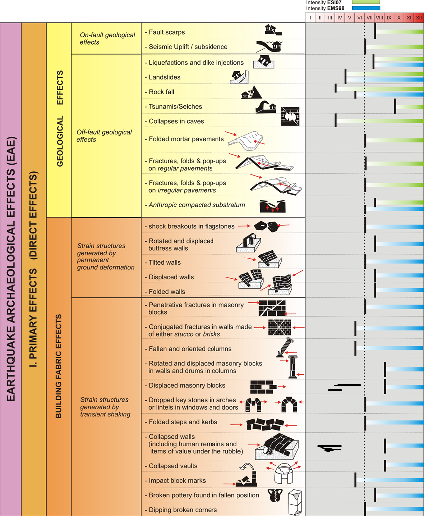
  • Environmental Effects (ESI 2007)
  • Synoptic Table of ESI 2007    Intensity Degrees from Michetti et al. (2007)
  • Environmental Effects vs. Intensity from Michetti et al. (2007)
  • Intensity vs. PGA from Abdelmonem (2014)
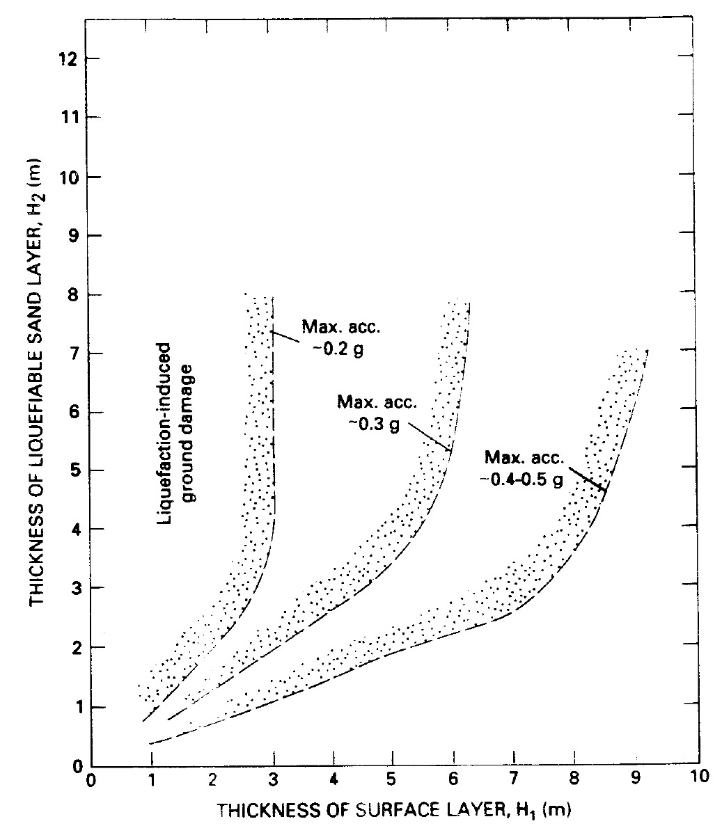
Estimate PGA of Sand Boils

Fig. 9

Proposed boundary curves relating thickness of nonliquefiable surface layer to thickness of the liquefiable zone as a function of peak earthquake accelerations required to induce venting or ground rupturing at the surface

From Ishihara (1985)

click on image to open in a new tab

Obermeier (1996)


Variable Input Units Notes
g Peak Horizontal Ground Acceleration
Variable Output - Site Effect not considered Units Notes
unitless Conversion from PGA to Intensity using Wald et al (1999)
  

References
References