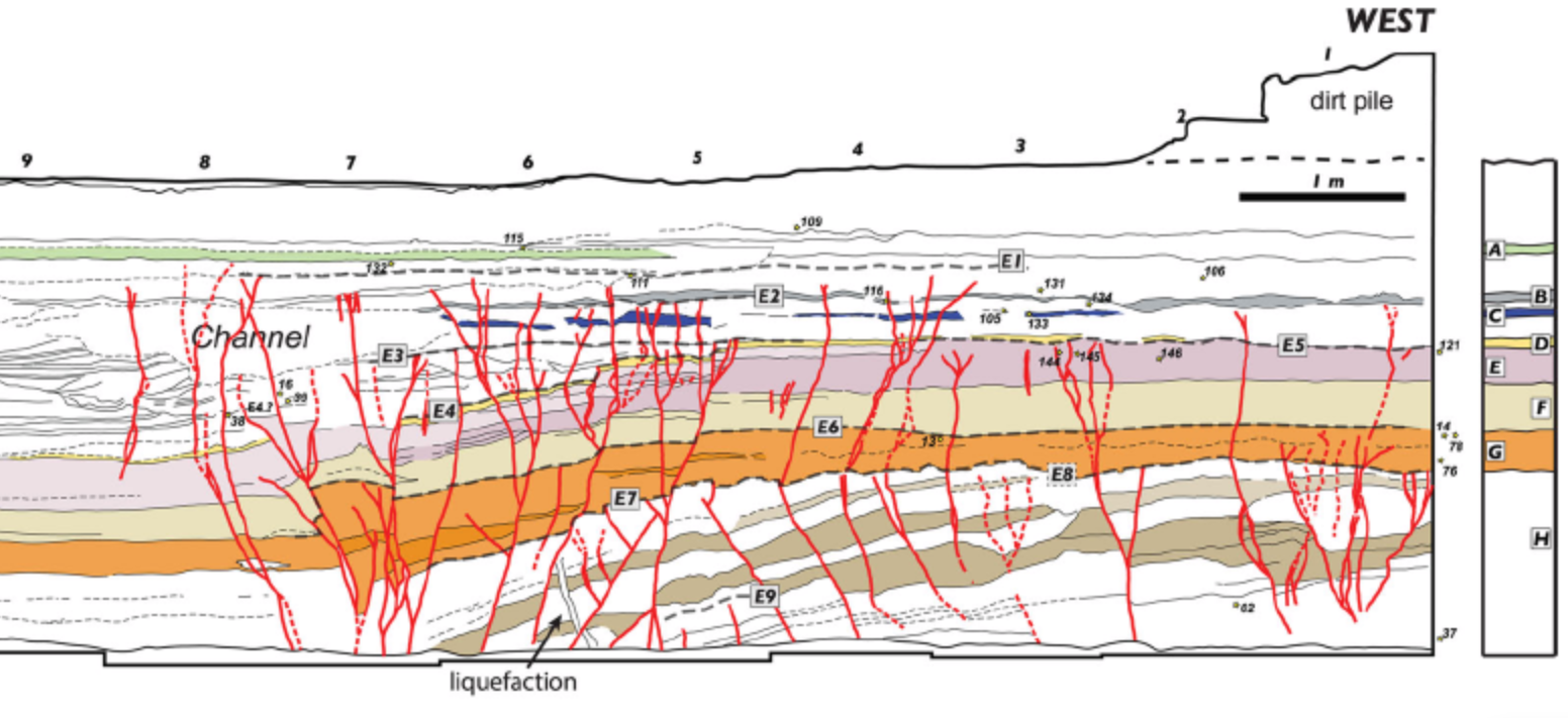
Event E7

In the Qatar Trench, oriented perpendicular to the
Arava Fault
within the Yotvata Playa and just south of the
Yotvata extensional step,
Klinger et al. (2015)
identify Event E7 as a prehistoric rupture in the
lower part of the trench sequence, younger than E8
and older than E6. Evidence is restricted to the
western fault zone of the trench and is expressed by
a set of faults below
MM5
that dip both eastward and westward and offset the
top of unit H. Most of these faults do not continue
upward into unit G, and they also offset the Esupp2
liquefaction conduit
close to its base. In this respect, E7 is defined
not by major tilting or pronounced
subsidence like E8, but by a renewed phase of
faulting that broke the upper part of unit H and
reactivated structures in the main fault zone.
Most of the faults related to E7 are sealed by G,
which leads Klinger et al. to place the E7 event
horizon at the boundary between units H and G. This
is also the level used for E8 in their figure, but
they stress that the actual event horizon of E8 is
obscured by the fact that the H-G contact is an
erosional contact that postdates E8.
Some faults activated during E7 were reused by later
ruptures, producing larger cumulative vertical offset
in the lower part of the trench than in the upper
part. This overprinting complicates the structural
history, but it also shows that E7 was a distinct
surface-breaking event within a repeatedly reactivated
fault network. Unlike E8, which involved substantial
tilting of unit H and probable creation of
accommodation space, E7 is expressed more as a
crack- and fault-dominated rupture. According to
Klinger et al. (2015), this
indicates that it is likely that E7 was created by a fault rupture that terminated at the
Yotvata extensional step.
Chronologically, E7 is much better constrained than
the older E8-E9 sequence.
Klinger et al. (2015)
place E7 between 338 BCE and 213 BCE on the basis of a
Bayesian model
using
radiocarbon dates
from
detrital charcoal.