Yönlü and Karabacak (2023:6) report that the
oldest event in the trench was identified as a fault splay that
terminates below unit d
and cuts unit c. A radiocarbon sample from
overlying unit d produced a calibrated age of 7561-7131 BCE while a radiocarbon
sample from unit c which predates Event T produced a calibrated age of 8591-7961 BCE.
Thus, Event T is constrained to between 8591 and 7131 BCE.
We investigate the palaeo earthquakes and slip rate on the Pazarcık segment of the East Anatolian Fault, which was involved in the surface rupture of the 6 February 2023 Pazarcık–Kahramanmaraş earthquake (MW 7.7) and provided insights into the long-term behaviour of this major continental fault. Palaeoseismological data from two trench sites reveal evidence for at least five surface ruptures in the Holocene Period. The historical earthquake of AD 1114 is verified at both trench sites but the following event of AD 1513 is identified at only one site. In addition, the age difference of the older events shows that historical activity is separated by much longer periods of relative quiescence that range from 500 to 1000 years, which suggests quasiperiodic earthquake occurrence on sub-segments of the Pazarcık segment. Our fault-parallel trenches revealed 101 ± 5 m offset in the last 18 kyr and 51 ± 1 m offset in the last 9 kyr on a buried stream channel and the actual channel of the same stream respectively. The correlation of the maximum and abandonment age of the channel with measured offsets revealed a 5.6 mm a-1 long-term slip rate of the fault.
The left lateral East Anatolian Fault (EAF) is one of the major transform faults of the Eastern Mediterranean region (Fig. 1a). The fault extends for about 550 km between Karlıova and Türkoğlu where it meets the North Anatolian Fault (NAF) to the NE and the Dead Sea Fault to the SW (Fig. 1b). The northward motion of the Arabian Plate is taken up by the EAF, together with the NAF, accommodating the westward extrusion of the Anatolian Block. The EAF is often considered a continuation of the Dead Sea Fault to the north where differential motion of the Arabian Peninsula relative to the African plate occurs (Fig. 1a) (McKenzie 1972; Şengör et al. 1985). In the most recent comprehensive study Duman and Emre (2013) studied the fault and divided it into seven segments based on fault step-overs, jogs or changes in fault strike between Karlıova and the Amik Basin. There are different opinions on the location of the intersection between the Dead Sea Fault and the EAF; some researchers (e.g. McKenzie 1970, 1972; Dewey et al. 1973; Şengör 1980; Jackson and McKenzie 1984; Hempton 1987; Barka and Kadinsky-Cade 1988; Kempler and Garfunkel 1991; Westaway and Arger 1996; Koçyiğit and Erol 2001; Yönlü et al. 2017) have suggested Türkoğlu whereas others (e.g. Allen 1969; Arpat and Şaroğlu 1975; Şengör et al. 1985; Kelling et al. 1987; Şaroğlu et al. 1992; Över et al. 2004; Duman and Emre 2013) have considered the Amik Basin as the location. The left lateral Karasu Fault extends along the western margin of the Karasu Valley between the two proposed intersection areas (i.e. from Türkoğlu in the north to the Amik Basin in the south). The Karasu Fault, thus, is known to transfer a significant amount of slip between the EAF and the Dead Sea Fault, although there is still discussion on which fault system the Karasu Fault belongs to.
The Pazarcık segment is the southernmost segment of the EAF before it intersects the Karasu Fault near Türkoğlu (Fig. 1b). The Pazarcık segment provides field evidence of sinistral displacement of stream beds by a few metres to kilometres, and faulted alluvial and colluvial deposits that extend for about 90 km between the Gölbası̧ Basin in the NE and Türkoğlu in the SW (Fig. 2). Between Gölbası̧ and Türkoğlu, the fault extends in pre-Quaternary rock units along most of its length. It cuts Quaternary deposits in limited areas in the Gölbası̧ Basin to the NE and around Türkoğlu in the SW. The general morphology of the fault is characterized by linear topography and large cumulative offsets in river channels (Fig. 2). It can be traced by fault-related geomorphological features such as offset stream channels, elongated and shutter ridges, linear saddles, scarps and depressions that are aligned on a single trace. To the NE a left bend near Gölbası̧ Lake forms the segment boundary between the Pazarcık and Erkenek segments (Fig. 2). The fault bounds the southeastern margin of the Gölbası̧ Basin and caused a cumulative offset on the Aksu Stream of 16.5 km (Yönlü et al. 2013). Further SW of the Gölbası̧ Basin, the fault extends in a high-relief area where three major stream channels, from south to north the Kısık, Koca and Gök streams, have recorded left lateral offsets of 4.4, 4.5 and 6.4 km, respectively (Fig. 2). Besides these large cumulative offsets, the majority of the stream channels show some evidence of left lateral offset on the fault trace. Near Kartal village, the fault makes a 1.5 km wide right bend, which causes uplift of the southern block owing to local transpression (Fig. 2). Based on the Kartal restraining bend, the Pazarcık segment can be separated into two geometrical subsections, namely the Gölbası̧ and Tevekkelli sub-sections (Fig. 2). It forms the contact of Cretaceous Neotethyan ophiolite and Quaternary alluvium between the towns of Çiğli and Küpelikız and follows the SE-facing escarpment. This is one of the areas where the fault disrupts the Quaternary deposits. Left laterally displaced stream channels in the Holocene sediments indicate the recent activity of the fault. Further SW, elongated ridges, offset stream beds and shutter ridges are the geomorphological evidence of active faulting. The morphological expression of the fault diminishes to the east of Türkoğlu where it enters the Aksu River alluvial plain (Fig. 2).
To retrieve the chronology of historical earthquakes that ruptured the surface on the Pazarcık segment, we excavated trenches at two sites in 2010 and 2011. Our trench sites are located near the NE and SW ends of the Pazarcık segment (Fig. 2). Our trenching attempts in a small depression near Kartal village in the middle of the segment did not provide sufficient information because of the thick, chaotic bedded, coarse sediments encountered in the trench. In our successful trench locations in the Gölbası Basin to the NE and at Tevekkelli to the SW, the Pazarcık–Kahramanmaraş 2023 earthquake ruptured the surface as a single line, indicating successful trench location selection.
The Balkar trench site is located in the Gölbası̧ Basin to the NE (Fig. 2). In this area the fault is characterized by pressure ridges, shutter ridges and left lateral offset stream beds indicating long-term activity. Our trench site lies to the NE of a fault-parallel elongated ridge, on farm fields gently sloping towards the NW (Fig. 3a).
The faulting is confined to a 1 m wide zone at the SE end of the trench. The repeated surface ruptures caused intense deformation along this narrow zone. Owing to numerous movements in the same narrow zone the traces of the past surface ruptures overlapped each other, making it impossible to distinguish different earthquake records. The trace of the most recent earthquake extended up to the base of the present soil (Fig. 4).
The Tevekkeli trench site is located in the southwestern part of the Pazarcık segment between Kocalar and Tevekkeli villages (Fig. 2), about 10 km NE of Türkoğlu. The EAF at this site is expressed as a single, geomorphologically well-defined strand. It is characterized by left laterally displaced stream channels and fault scarps, juxtaposing different rock units in the area. The cumulative 1.3 ± 0.2 km offset on an ephemeral stream (Fig. 3b and Supplementary material Fig. S1) indicates the long-term slip that developed on the fault at this locality. The offset stream geometry and linear shutter ridge in the area show that the fault motion occurs in a narrow zone, as shown by the 2023 surface rupture (Fig. 3b). Our fault mapping prior to the earthquake and the surface rupture mapping after the 2023 event support the view that the fault constitutes a single trace without additional secondary splays (Fig. 3b).
T1 is a fault-perpendicular trench excavated for accurate fault location and investigation of surface-rupturing events (Fig. 5). The 20 m long by 3 m deep trench was dug where a prominent narrow lineament and a low-relief scarp are present. It revealed well-stratified sedimentary units cut by discrete shear planes (Fig. 6).
The stream in this trench area flows across the fault zone on relatively flat topography (Fig. 5). The width of the stream bed varies between 3 and 6 m, and the active channel is about 1–2 m wide. The active channel bed comprises gravel and sand, transported from the elevated ground to the north. The channel was surveyed by differential (D-GPS in 2011 and the left lateral offset on the channel was recorded as 48 ± 1 m (Fig. 5). It should be noted that Karabacak et al. (2023) measured 3 m of left lateral coseismic offsets near this area after the 2023 Pazarcık–Kahramanmaraş earthquake, thus the total offset on the channel is 51 m at present. Actual channel geometry and total offset indicate that the stream channel has followed the same route for a long time. However, although it is difficult to generate new channel incisions in a flat topography following slip on the fault, a semi-flat topography favours the formation of at least one new stream channel.
Our trenches at the Balkar and Tevekkelli sites provided evidence of repeated surface rupturing events on the Pazarcık segment of the EAF. In addition to the 1513 and 1114 earthquakes, we found evidence of at least three, or possibly more, earlier surface ruptures during the past 10,000 years. The historical 1513 earthquake has been identified in the Tevekkelli trench but not in the Balkar trench in the Gölbası̧ Basin. This may suggest two possible scenarios.
Our three fault-parallel trenches on an abandoned and displaced stream channel have provided the first palaeoseismological slip rate estimate for the Pazarcık segment of the EAF. According to the age dating of buried stream deposits and the cumulative slip measured on the actual and abandoned stream channels, we measured 98 ± 5 and 48 ± 1 m offsets accumulated over a period of 17 800 and 9000 years, respectively. Considering the slip of the 6 February 2023 Pazarcık–Kahramanmaraş earthquake on top of the cumulative offsets measured in 2011 (Karabacak et al. 2023), 3 m offset was added to the cumulative slip after the earthquake. Therefore, the cumulative offset on the abandoned and actual stream is 101 ± 5 and 51 ± 1 m after the earthquake. The offset amounts and age dating revealed 5.6 ± 0.3 mm a−1 slip of the fault (Fig. 8). The fact that the slip rate for two different long periods is the same can be interpreted as indicating no significant change in the slip rate of the fault in the last 18 kyr.
We found evidence for at least five and possibly more surface ruptures over the past 10 kyr in our palaeoseismological trenches along the Pazarcık segment of the EAF. We have not identified evidence of the 1513 earthquake in our Balkar trench and we interpret that this event did not generate a surface rupture through the Gölbası̧ Basin. The 1513 earthquake rupture most probably was terminated to the NE by the Kartal restraining bend, which represents the most prominent change in the fault trend. The historical 1114 earthquake was recognized at both trench sites in the NE and SW parts of the segment. Considering the extensive damage reported across the Kahramanmaraş region in historical accounts and the rupture observed in the trenches, we suggest that the 1114 earthquake ruptured at least the entire Pazarcık segment and possibly produced a surface rupture of similar length to the 6 February 2023 Pazarcık–Kahramanmaraş earthquake.
A radiocarbon sample from unit h post dating event U produced a calibrated age of 3321-2871 BCE while a sample from
unit f which predates Event U produced a calibrated age of 5961-5631 BCE. These two samples, in turn constrain Event U to between 5691 and 2871 BCE.
We investigate the palaeo earthquakes and slip rate on the Pazarcık segment of the East Anatolian Fault, which was involved in the surface rupture of the 6 February 2023 Pazarcık–Kahramanmaraş earthquake (MW 7.7) and provided insights into the long-term behaviour of this major continental fault. Palaeoseismological data from two trench sites reveal evidence for at least five surface ruptures in the Holocene Period. The historical earthquake of AD 1114 is verified at both trench sites but the following event of AD 1513 is identified at only one site. In addition, the age difference of the older events shows that historical activity is separated by much longer periods of relative quiescence that range from 500 to 1000 years, which suggests quasiperiodic earthquake occurrence on sub-segments of the Pazarcık segment. Our fault-parallel trenches revealed 101 ± 5 m offset in the last 18 kyr and 51 ± 1 m offset in the last 9 kyr on a buried stream channel and the actual channel of the same stream respectively. The correlation of the maximum and abandonment age of the channel with measured offsets revealed a 5.6 mm a-1 long-term slip rate of the fault.
The left lateral East Anatolian Fault (EAF) is one of the major transform faults of the Eastern Mediterranean region (Fig. 1a). The fault extends for about 550 km between Karlıova and Türkoğlu where it meets the North Anatolian Fault (NAF) to the NE and the Dead Sea Fault to the SW (Fig. 1b). The northward motion of the Arabian Plate is taken up by the EAF, together with the NAF, accommodating the westward extrusion of the Anatolian Block. The EAF is often considered a continuation of the Dead Sea Fault to the north where differential motion of the Arabian Peninsula relative to the African plate occurs (Fig. 1a) (McKenzie 1972; Şengör et al. 1985). In the most recent comprehensive study Duman and Emre (2013) studied the fault and divided it into seven segments based on fault step-overs, jogs or changes in fault strike between Karlıova and the Amik Basin. There are different opinions on the location of the intersection between the Dead Sea Fault and the EAF; some researchers (e.g. McKenzie 1970, 1972; Dewey et al. 1973; Şengör 1980; Jackson and McKenzie 1984; Hempton 1987; Barka and Kadinsky-Cade 1988; Kempler and Garfunkel 1991; Westaway and Arger 1996; Koçyiğit and Erol 2001; Yönlü et al. 2017) have suggested Türkoğlu whereas others (e.g. Allen 1969; Arpat and Şaroğlu 1975; Şengör et al. 1985; Kelling et al. 1987; Şaroğlu et al. 1992; Över et al. 2004; Duman and Emre 2013) have considered the Amik Basin as the location. The left lateral Karasu Fault extends along the western margin of the Karasu Valley between the two proposed intersection areas (i.e. from Türkoğlu in the north to the Amik Basin in the south). The Karasu Fault, thus, is known to transfer a significant amount of slip between the EAF and the Dead Sea Fault, although there is still discussion on which fault system the Karasu Fault belongs to.
The Pazarcık segment is the southernmost segment of the EAF before it intersects the Karasu Fault near Türkoğlu (Fig. 1b). The Pazarcık segment provides field evidence of sinistral displacement of stream beds by a few metres to kilometres, and faulted alluvial and colluvial deposits that extend for about 90 km between the Gölbası̧ Basin in the NE and Türkoğlu in the SW (Fig. 2). Between Gölbası̧ and Türkoğlu, the fault extends in pre-Quaternary rock units along most of its length. It cuts Quaternary deposits in limited areas in the Gölbası̧ Basin to the NE and around Türkoğlu in the SW. The general morphology of the fault is characterized by linear topography and large cumulative offsets in river channels (Fig. 2). It can be traced by fault-related geomorphological features such as offset stream channels, elongated and shutter ridges, linear saddles, scarps and depressions that are aligned on a single trace. To the NE a left bend near Gölbası̧ Lake forms the segment boundary between the Pazarcık and Erkenek segments (Fig. 2). The fault bounds the southeastern margin of the Gölbası̧ Basin and caused a cumulative offset on the Aksu Stream of 16.5 km (Yönlü et al. 2013). Further SW of the Gölbası̧ Basin, the fault extends in a high-relief area where three major stream channels, from south to north the Kısık, Koca and Gök streams, have recorded left lateral offsets of 4.4, 4.5 and 6.4 km, respectively (Fig. 2). Besides these large cumulative offsets, the majority of the stream channels show some evidence of left lateral offset on the fault trace. Near Kartal village, the fault makes a 1.5 km wide right bend, which causes uplift of the southern block owing to local transpression (Fig. 2). Based on the Kartal restraining bend, the Pazarcık segment can be separated into two geometrical subsections, namely the Gölbası̧ and Tevekkelli sub-sections (Fig. 2). It forms the contact of Cretaceous Neotethyan ophiolite and Quaternary alluvium between the towns of Çiğli and Küpelikız and follows the SE-facing escarpment. This is one of the areas where the fault disrupts the Quaternary deposits. Left laterally displaced stream channels in the Holocene sediments indicate the recent activity of the fault. Further SW, elongated ridges, offset stream beds and shutter ridges are the geomorphological evidence of active faulting. The morphological expression of the fault diminishes to the east of Türkoğlu where it enters the Aksu River alluvial plain (Fig. 2).
To retrieve the chronology of historical earthquakes that ruptured the surface on the Pazarcık segment, we excavated trenches at two sites in 2010 and 2011. Our trench sites are located near the NE and SW ends of the Pazarcık segment (Fig. 2). Our trenching attempts in a small depression near Kartal village in the middle of the segment did not provide sufficient information because of the thick, chaotic bedded, coarse sediments encountered in the trench. In our successful trench locations in the Gölbası Basin to the NE and at Tevekkelli to the SW, the Pazarcık–Kahramanmaraş 2023 earthquake ruptured the surface as a single line, indicating successful trench location selection.
The Balkar trench site is located in the Gölbası̧ Basin to the NE (Fig. 2). In this area the fault is characterized by pressure ridges, shutter ridges and left lateral offset stream beds indicating long-term activity. Our trench site lies to the NE of a fault-parallel elongated ridge, on farm fields gently sloping towards the NW (Fig. 3a).
The faulting is confined to a 1 m wide zone at the SE end of the trench. The repeated surface ruptures caused intense deformation along this narrow zone. Owing to numerous movements in the same narrow zone the traces of the past surface ruptures overlapped each other, making it impossible to distinguish different earthquake records. The trace of the most recent earthquake extended up to the base of the present soil (Fig. 4).
The Tevekkeli trench site is located in the southwestern part of the Pazarcık segment between Kocalar and Tevekkeli villages (Fig. 2), about 10 km NE of Türkoğlu. The EAF at this site is expressed as a single, geomorphologically well-defined strand. It is characterized by left laterally displaced stream channels and fault scarps, juxtaposing different rock units in the area. The cumulative 1.3 ± 0.2 km offset on an ephemeral stream (Fig. 3b and Supplementary material Fig. S1) indicates the long-term slip that developed on the fault at this locality. The offset stream geometry and linear shutter ridge in the area show that the fault motion occurs in a narrow zone, as shown by the 2023 surface rupture (Fig. 3b). Our fault mapping prior to the earthquake and the surface rupture mapping after the 2023 event support the view that the fault constitutes a single trace without additional secondary splays (Fig. 3b).
T1 is a fault-perpendicular trench excavated for accurate fault location and investigation of surface-rupturing events (Fig. 5). The 20 m long by 3 m deep trench was dug where a prominent narrow lineament and a low-relief scarp are present. It revealed well-stratified sedimentary units cut by discrete shear planes (Fig. 6).
The stream in this trench area flows across the fault zone on relatively flat topography (Fig. 5). The width of the stream bed varies between 3 and 6 m, and the active channel is about 1–2 m wide. The active channel bed comprises gravel and sand, transported from the elevated ground to the north. The channel was surveyed by differential (D-GPS in 2011 and the left lateral offset on the channel was recorded as 48 ± 1 m (Fig. 5). It should be noted that Karabacak et al. (2023) measured 3 m of left lateral coseismic offsets near this area after the 2023 Pazarcık–Kahramanmaraş earthquake, thus the total offset on the channel is 51 m at present. Actual channel geometry and total offset indicate that the stream channel has followed the same route for a long time. However, although it is difficult to generate new channel incisions in a flat topography following slip on the fault, a semi-flat topography favours the formation of at least one new stream channel.
Our trenches at the Balkar and Tevekkelli sites provided evidence of repeated surface rupturing events on the Pazarcık segment of the EAF. In addition to the 1513 and 1114 earthquakes, we found evidence of at least three, or possibly more, earlier surface ruptures during the past 10,000 years. The historical 1513 earthquake has been identified in the Tevekkelli trench but not in the Balkar trench in the Gölbası̧ Basin. This may suggest two possible scenarios.
Our three fault-parallel trenches on an abandoned and displaced stream channel have provided the first palaeoseismological slip rate estimate for the Pazarcık segment of the EAF. According to the age dating of buried stream deposits and the cumulative slip measured on the actual and abandoned stream channels, we measured 98 ± 5 and 48 ± 1 m offsets accumulated over a period of 17 800 and 9000 years, respectively. Considering the slip of the 6 February 2023 Pazarcık–Kahramanmaraş earthquake on top of the cumulative offsets measured in 2011 (Karabacak et al. 2023), 3 m offset was added to the cumulative slip after the earthquake. Therefore, the cumulative offset on the abandoned and actual stream is 101 ± 5 and 51 ± 1 m after the earthquake. The offset amounts and age dating revealed 5.6 ± 0.3 mm a−1 slip of the fault (Fig. 8). The fact that the slip rate for two different long periods is the same can be interpreted as indicating no significant change in the slip rate of the fault in the last 18 kyr.
We found evidence for at least five and possibly more surface ruptures over the past 10 kyr in our palaeoseismological trenches along the Pazarcık segment of the EAF. We have not identified evidence of the 1513 earthquake in our Balkar trench and we interpret that this event did not generate a surface rupture through the Gölbası̧ Basin. The 1513 earthquake rupture most probably was terminated to the NE by the Kartal restraining bend, which represents the most prominent change in the fault trend. The historical 1114 earthquake was recognized at both trench sites in the NE and SW parts of the segment. Considering the extensive damage reported across the Kahramanmaraş region in historical accounts and the rupture observed in the trenches, we suggest that the 1114 earthquake ruptured at least the entire Pazarcık segment and possibly produced a surface rupture of similar length to the 6 February 2023 Pazarcık–Kahramanmaraş earthquake.
A radiocarbon sample from unit h post dating event V produced a calibrated age of 3321-2871 BCE while a sample from
unit f which predates Event V produced a calibrated age of 5961-5631 BCE. These two samples, in turn constrain Event V to between 5691 and 2871 BCE.
We investigate the palaeo earthquakes and slip rate on the Pazarcık segment of the East Anatolian Fault, which was involved in the surface rupture of the 6 February 2023 Pazarcık–Kahramanmaraş earthquake (MW 7.7) and provided insights into the long-term behaviour of this major continental fault. Palaeoseismological data from two trench sites reveal evidence for at least five surface ruptures in the Holocene Period. The historical earthquake of AD 1114 is verified at both trench sites but the following event of AD 1513 is identified at only one site. In addition, the age difference of the older events shows that historical activity is separated by much longer periods of relative quiescence that range from 500 to 1000 years, which suggests quasiperiodic earthquake occurrence on sub-segments of the Pazarcık segment. Our fault-parallel trenches revealed 101 ± 5 m offset in the last 18 kyr and 51 ± 1 m offset in the last 9 kyr on a buried stream channel and the actual channel of the same stream respectively. The correlation of the maximum and abandonment age of the channel with measured offsets revealed a 5.6 mm a-1 long-term slip rate of the fault.
The left lateral East Anatolian Fault (EAF) is one of the major transform faults of the Eastern Mediterranean region (Fig. 1a). The fault extends for about 550 km between Karlıova and Türkoğlu where it meets the North Anatolian Fault (NAF) to the NE and the Dead Sea Fault to the SW (Fig. 1b). The northward motion of the Arabian Plate is taken up by the EAF, together with the NAF, accommodating the westward extrusion of the Anatolian Block. The EAF is often considered a continuation of the Dead Sea Fault to the north where differential motion of the Arabian Peninsula relative to the African plate occurs (Fig. 1a) (McKenzie 1972; Şengör et al. 1985). In the most recent comprehensive study Duman and Emre (2013) studied the fault and divided it into seven segments based on fault step-overs, jogs or changes in fault strike between Karlıova and the Amik Basin. There are different opinions on the location of the intersection between the Dead Sea Fault and the EAF; some researchers (e.g. McKenzie 1970, 1972; Dewey et al. 1973; Şengör 1980; Jackson and McKenzie 1984; Hempton 1987; Barka and Kadinsky-Cade 1988; Kempler and Garfunkel 1991; Westaway and Arger 1996; Koçyiğit and Erol 2001; Yönlü et al. 2017) have suggested Türkoğlu whereas others (e.g. Allen 1969; Arpat and Şaroğlu 1975; Şengör et al. 1985; Kelling et al. 1987; Şaroğlu et al. 1992; Över et al. 2004; Duman and Emre 2013) have considered the Amik Basin as the location. The left lateral Karasu Fault extends along the western margin of the Karasu Valley between the two proposed intersection areas (i.e. from Türkoğlu in the north to the Amik Basin in the south). The Karasu Fault, thus, is known to transfer a significant amount of slip between the EAF and the Dead Sea Fault, although there is still discussion on which fault system the Karasu Fault belongs to.
The Pazarcık segment is the southernmost segment of the EAF before it intersects the Karasu Fault near Türkoğlu (Fig. 1b). The Pazarcık segment provides field evidence of sinistral displacement of stream beds by a few metres to kilometres, and faulted alluvial and colluvial deposits that extend for about 90 km between the Gölbası̧ Basin in the NE and Türkoğlu in the SW (Fig. 2). Between Gölbası̧ and Türkoğlu, the fault extends in pre-Quaternary rock units along most of its length. It cuts Quaternary deposits in limited areas in the Gölbası̧ Basin to the NE and around Türkoğlu in the SW. The general morphology of the fault is characterized by linear topography and large cumulative offsets in river channels (Fig. 2). It can be traced by fault-related geomorphological features such as offset stream channels, elongated and shutter ridges, linear saddles, scarps and depressions that are aligned on a single trace. To the NE a left bend near Gölbası̧ Lake forms the segment boundary between the Pazarcık and Erkenek segments (Fig. 2). The fault bounds the southeastern margin of the Gölbası̧ Basin and caused a cumulative offset on the Aksu Stream of 16.5 km (Yönlü et al. 2013). Further SW of the Gölbası̧ Basin, the fault extends in a high-relief area where three major stream channels, from south to north the Kısık, Koca and Gök streams, have recorded left lateral offsets of 4.4, 4.5 and 6.4 km, respectively (Fig. 2). Besides these large cumulative offsets, the majority of the stream channels show some evidence of left lateral offset on the fault trace. Near Kartal village, the fault makes a 1.5 km wide right bend, which causes uplift of the southern block owing to local transpression (Fig. 2). Based on the Kartal restraining bend, the Pazarcık segment can be separated into two geometrical subsections, namely the Gölbası̧ and Tevekkelli sub-sections (Fig. 2). It forms the contact of Cretaceous Neotethyan ophiolite and Quaternary alluvium between the towns of Çiğli and Küpelikız and follows the SE-facing escarpment. This is one of the areas where the fault disrupts the Quaternary deposits. Left laterally displaced stream channels in the Holocene sediments indicate the recent activity of the fault. Further SW, elongated ridges, offset stream beds and shutter ridges are the geomorphological evidence of active faulting. The morphological expression of the fault diminishes to the east of Türkoğlu where it enters the Aksu River alluvial plain (Fig. 2).
To retrieve the chronology of historical earthquakes that ruptured the surface on the Pazarcık segment, we excavated trenches at two sites in 2010 and 2011. Our trench sites are located near the NE and SW ends of the Pazarcık segment (Fig. 2). Our trenching attempts in a small depression near Kartal village in the middle of the segment did not provide sufficient information because of the thick, chaotic bedded, coarse sediments encountered in the trench. In our successful trench locations in the Gölbası Basin to the NE and at Tevekkelli to the SW, the Pazarcık–Kahramanmaraş 2023 earthquake ruptured the surface as a single line, indicating successful trench location selection.
The Balkar trench site is located in the Gölbası̧ Basin to the NE (Fig. 2). In this area the fault is characterized by pressure ridges, shutter ridges and left lateral offset stream beds indicating long-term activity. Our trench site lies to the NE of a fault-parallel elongated ridge, on farm fields gently sloping towards the NW (Fig. 3a).
The faulting is confined to a 1 m wide zone at the SE end of the trench. The repeated surface ruptures caused intense deformation along this narrow zone. Owing to numerous movements in the same narrow zone the traces of the past surface ruptures overlapped each other, making it impossible to distinguish different earthquake records. The trace of the most recent earthquake extended up to the base of the present soil (Fig. 4).
The Tevekkeli trench site is located in the southwestern part of the Pazarcık segment between Kocalar and Tevekkeli villages (Fig. 2), about 10 km NE of Türkoğlu. The EAF at this site is expressed as a single, geomorphologically well-defined strand. It is characterized by left laterally displaced stream channels and fault scarps, juxtaposing different rock units in the area. The cumulative 1.3 ± 0.2 km offset on an ephemeral stream (Fig. 3b and Supplementary material Fig. S1) indicates the long-term slip that developed on the fault at this locality. The offset stream geometry and linear shutter ridge in the area show that the fault motion occurs in a narrow zone, as shown by the 2023 surface rupture (Fig. 3b). Our fault mapping prior to the earthquake and the surface rupture mapping after the 2023 event support the view that the fault constitutes a single trace without additional secondary splays (Fig. 3b).
T1 is a fault-perpendicular trench excavated for accurate fault location and investigation of surface-rupturing events (Fig. 5). The 20 m long by 3 m deep trench was dug where a prominent narrow lineament and a low-relief scarp are present. It revealed well-stratified sedimentary units cut by discrete shear planes (Fig. 6).
The stream in this trench area flows across the fault zone on relatively flat topography (Fig. 5). The width of the stream bed varies between 3 and 6 m, and the active channel is about 1–2 m wide. The active channel bed comprises gravel and sand, transported from the elevated ground to the north. The channel was surveyed by differential (D-GPS in 2011 and the left lateral offset on the channel was recorded as 48 ± 1 m (Fig. 5). It should be noted that Karabacak et al. (2023) measured 3 m of left lateral coseismic offsets near this area after the 2023 Pazarcık–Kahramanmaraş earthquake, thus the total offset on the channel is 51 m at present. Actual channel geometry and total offset indicate that the stream channel has followed the same route for a long time. However, although it is difficult to generate new channel incisions in a flat topography following slip on the fault, a semi-flat topography favours the formation of at least one new stream channel.
Our trenches at the Balkar and Tevekkelli sites provided evidence of repeated surface rupturing events on the Pazarcık segment of the EAF. In addition to the 1513 and 1114 earthquakes, we found evidence of at least three, or possibly more, earlier surface ruptures during the past 10,000 years. The historical 1513 earthquake has been identified in the Tevekkelli trench but not in the Balkar trench in the Gölbası̧ Basin. This may suggest two possible scenarios.
Our three fault-parallel trenches on an abandoned and displaced stream channel have provided the first palaeoseismological slip rate estimate for the Pazarcık segment of the EAF. According to the age dating of buried stream deposits and the cumulative slip measured on the actual and abandoned stream channels, we measured 98 ± 5 and 48 ± 1 m offsets accumulated over a period of 17 800 and 9000 years, respectively. Considering the slip of the 6 February 2023 Pazarcık–Kahramanmaraş earthquake on top of the cumulative offsets measured in 2011 (Karabacak et al. 2023), 3 m offset was added to the cumulative slip after the earthquake. Therefore, the cumulative offset on the abandoned and actual stream is 101 ± 5 and 51 ± 1 m after the earthquake. The offset amounts and age dating revealed 5.6 ± 0.3 mm a−1 slip of the fault (Fig. 8). The fact that the slip rate for two different long periods is the same can be interpreted as indicating no significant change in the slip rate of the fault in the last 18 kyr.
We found evidence for at least five and possibly more surface ruptures over the past 10 kyr in our palaeoseismological trenches along the Pazarcık segment of the EAF. We have not identified evidence of the 1513 earthquake in our Balkar trench and we interpret that this event did not generate a surface rupture through the Gölbası̧ Basin. The 1513 earthquake rupture most probably was terminated to the NE by the Kartal restraining bend, which represents the most prominent change in the fault trend. The historical 1114 earthquake was recognized at both trench sites in the NE and SW parts of the segment. Considering the extensive damage reported across the Kahramanmaraş region in historical accounts and the rupture observed in the trenches, we suggest that the 1114 earthquake ruptured at least the entire Pazarcık segment and possibly produced a surface rupture of similar length to the 6 February 2023 Pazarcık–Kahramanmaraş earthquake.
Although no discrete fault splays predating Event X were identified in Balkar Trench T2,
Yönlü and Karabacak (2023:4) found evidence of tilting, which they attributed to past earthquakes.
They noted that southeast-dipping Units 11 and 12 had back-tilted against
the local topography, likely causing ponding. This ponding created the depositional
conditions that led to the formation of the organic-rich clay found in Units 13 and 14,
which were later covered by colluvial deposits.
Based on their interpretation,
Yönlü and Karabacak (2023:4) suggest that Unit 13 predates one past earthquake, while Unit 16 predates another.
A radiocarbon sample from Unit 13 yielded a calibrated age of 2811–2411 BCE,
while a sample from higher up Unit 15 provided a calibrated age of 2691–2391 BCE.
These results constrain the older of the two earthquakes to between 2811 and 2391 BCE.
We investigate the palaeo earthquakes and slip rate on the Pazarcık segment of the East Anatolian Fault, which was involved in the surface rupture of the 6 February 2023 Pazarcık–Kahramanmaraş earthquake (MW 7.7) and provided insights into the long-term behaviour of this major continental fault. Palaeoseismological data from two trench sites reveal evidence for at least five surface ruptures in the Holocene Period. The historical earthquake of AD 1114 is verified at both trench sites but the following event of AD 1513 is identified at only one site. In addition, the age difference of the older events shows that historical activity is separated by much longer periods of relative quiescence that range from 500 to 1000 years, which suggests quasiperiodic earthquake occurrence on sub-segments of the Pazarcık segment. Our fault-parallel trenches revealed 101 ± 5 m offset in the last 18 kyr and 51 ± 1 m offset in the last 9 kyr on a buried stream channel and the actual channel of the same stream respectively. The correlation of the maximum and abandonment age of the channel with measured offsets revealed a 5.6 mm a-1 long-term slip rate of the fault.
The left lateral East Anatolian Fault (EAF) is one of the major transform faults of the Eastern Mediterranean region (Fig. 1a). The fault extends for about 550 km between Karlıova and Türkoğlu where it meets the North Anatolian Fault (NAF) to the NE and the Dead Sea Fault to the SW (Fig. 1b). The northward motion of the Arabian Plate is taken up by the EAF, together with the NAF, accommodating the westward extrusion of the Anatolian Block. The EAF is often considered a continuation of the Dead Sea Fault to the north where differential motion of the Arabian Peninsula relative to the African plate occurs (Fig. 1a) (McKenzie 1972; Şengör et al. 1985). In the most recent comprehensive study Duman and Emre (2013) studied the fault and divided it into seven segments based on fault step-overs, jogs or changes in fault strike between Karlıova and the Amik Basin. There are different opinions on the location of the intersection between the Dead Sea Fault and the EAF; some researchers (e.g. McKenzie 1970, 1972; Dewey et al. 1973; Şengör 1980; Jackson and McKenzie 1984; Hempton 1987; Barka and Kadinsky-Cade 1988; Kempler and Garfunkel 1991; Westaway and Arger 1996; Koçyiğit and Erol 2001; Yönlü et al. 2017) have suggested Türkoğlu whereas others (e.g. Allen 1969; Arpat and Şaroğlu 1975; Şengör et al. 1985; Kelling et al. 1987; Şaroğlu et al. 1992; Över et al. 2004; Duman and Emre 2013) have considered the Amik Basin as the location. The left lateral Karasu Fault extends along the western margin of the Karasu Valley between the two proposed intersection areas (i.e. from Türkoğlu in the north to the Amik Basin in the south). The Karasu Fault, thus, is known to transfer a significant amount of slip between the EAF and the Dead Sea Fault, although there is still discussion on which fault system the Karasu Fault belongs to.
The Pazarcık segment is the southernmost segment of the EAF before it intersects the Karasu Fault near Türkoğlu (Fig. 1b). The Pazarcık segment provides field evidence of sinistral displacement of stream beds by a few metres to kilometres, and faulted alluvial and colluvial deposits that extend for about 90 km between the Gölbası̧ Basin in the NE and Türkoğlu in the SW (Fig. 2). Between Gölbası̧ and Türkoğlu, the fault extends in pre-Quaternary rock units along most of its length. It cuts Quaternary deposits in limited areas in the Gölbası̧ Basin to the NE and around Türkoğlu in the SW. The general morphology of the fault is characterized by linear topography and large cumulative offsets in river channels (Fig. 2). It can be traced by fault-related geomorphological features such as offset stream channels, elongated and shutter ridges, linear saddles, scarps and depressions that are aligned on a single trace. To the NE a left bend near Gölbası̧ Lake forms the segment boundary between the Pazarcık and Erkenek segments (Fig. 2). The fault bounds the southeastern margin of the Gölbası̧ Basin and caused a cumulative offset on the Aksu Stream of 16.5 km (Yönlü et al. 2013). Further SW of the Gölbası̧ Basin, the fault extends in a high-relief area where three major stream channels, from south to north the Kısık, Koca and Gök streams, have recorded left lateral offsets of 4.4, 4.5 and 6.4 km, respectively (Fig. 2). Besides these large cumulative offsets, the majority of the stream channels show some evidence of left lateral offset on the fault trace. Near Kartal village, the fault makes a 1.5 km wide right bend, which causes uplift of the southern block owing to local transpression (Fig. 2). Based on the Kartal restraining bend, the Pazarcık segment can be separated into two geometrical subsections, namely the Gölbası̧ and Tevekkelli sub-sections (Fig. 2). It forms the contact of Cretaceous Neotethyan ophiolite and Quaternary alluvium between the towns of Çiğli and Küpelikız and follows the SE-facing escarpment. This is one of the areas where the fault disrupts the Quaternary deposits. Left laterally displaced stream channels in the Holocene sediments indicate the recent activity of the fault. Further SW, elongated ridges, offset stream beds and shutter ridges are the geomorphological evidence of active faulting. The morphological expression of the fault diminishes to the east of Türkoğlu where it enters the Aksu River alluvial plain (Fig. 2).
To retrieve the chronology of historical earthquakes that ruptured the surface on the Pazarcık segment, we excavated trenches at two sites in 2010 and 2011. Our trench sites are located near the NE and SW ends of the Pazarcık segment (Fig. 2). Our trenching attempts in a small depression near Kartal village in the middle of the segment did not provide sufficient information because of the thick, chaotic bedded, coarse sediments encountered in the trench. In our successful trench locations in the Gölbası Basin to the NE and at Tevekkelli to the SW, the Pazarcık–Kahramanmaraş 2023 earthquake ruptured the surface as a single line, indicating successful trench location selection.
The Balkar trench site is located in the Gölbası̧ Basin to the NE (Fig. 2). In this area the fault is characterized by pressure ridges, shutter ridges and left lateral offset stream beds indicating long-term activity. Our trench site lies to the NE of a fault-parallel elongated ridge, on farm fields gently sloping towards the NW (Fig. 3a).
The faulting is confined to a 1 m wide zone at the SE end of the trench. The repeated surface ruptures caused intense deformation along this narrow zone. Owing to numerous movements in the same narrow zone the traces of the past surface ruptures overlapped each other, making it impossible to distinguish different earthquake records. The trace of the most recent earthquake extended up to the base of the present soil (Fig. 4).
The Tevekkeli trench site is located in the southwestern part of the Pazarcık segment between Kocalar and Tevekkeli villages (Fig. 2), about 10 km NE of Türkoğlu. The EAF at this site is expressed as a single, geomorphologically well-defined strand. It is characterized by left laterally displaced stream channels and fault scarps, juxtaposing different rock units in the area. The cumulative 1.3 ± 0.2 km offset on an ephemeral stream (Fig. 3b and Supplementary material Fig. S1) indicates the long-term slip that developed on the fault at this locality. The offset stream geometry and linear shutter ridge in the area show that the fault motion occurs in a narrow zone, as shown by the 2023 surface rupture (Fig. 3b). Our fault mapping prior to the earthquake and the surface rupture mapping after the 2023 event support the view that the fault constitutes a single trace without additional secondary splays (Fig. 3b).
T1 is a fault-perpendicular trench excavated for accurate fault location and investigation of surface-rupturing events (Fig. 5). The 20 m long by 3 m deep trench was dug where a prominent narrow lineament and a low-relief scarp are present. It revealed well-stratified sedimentary units cut by discrete shear planes (Fig. 6).
The stream in this trench area flows across the fault zone on relatively flat topography (Fig. 5). The width of the stream bed varies between 3 and 6 m, and the active channel is about 1–2 m wide. The active channel bed comprises gravel and sand, transported from the elevated ground to the north. The channel was surveyed by differential (D-GPS in 2011 and the left lateral offset on the channel was recorded as 48 ± 1 m (Fig. 5). It should be noted that Karabacak et al. (2023) measured 3 m of left lateral coseismic offsets near this area after the 2023 Pazarcık–Kahramanmaraş earthquake, thus the total offset on the channel is 51 m at present. Actual channel geometry and total offset indicate that the stream channel has followed the same route for a long time. However, although it is difficult to generate new channel incisions in a flat topography following slip on the fault, a semi-flat topography favours the formation of at least one new stream channel.
Our trenches at the Balkar and Tevekkelli sites provided evidence of repeated surface rupturing events on the Pazarcık segment of the EAF. In addition to the 1513 and 1114 earthquakes, we found evidence of at least three, or possibly more, earlier surface ruptures during the past 10,000 years. The historical 1513 earthquake has been identified in the Tevekkelli trench but not in the Balkar trench in the Gölbası̧ Basin. This may suggest two possible scenarios.
Our three fault-parallel trenches on an abandoned and displaced stream channel have provided the first palaeoseismological slip rate estimate for the Pazarcık segment of the EAF. According to the age dating of buried stream deposits and the cumulative slip measured on the actual and abandoned stream channels, we measured 98 ± 5 and 48 ± 1 m offsets accumulated over a period of 17 800 and 9000 years, respectively. Considering the slip of the 6 February 2023 Pazarcık–Kahramanmaraş earthquake on top of the cumulative offsets measured in 2011 (Karabacak et al. 2023), 3 m offset was added to the cumulative slip after the earthquake. Therefore, the cumulative offset on the abandoned and actual stream is 101 ± 5 and 51 ± 1 m after the earthquake. The offset amounts and age dating revealed 5.6 ± 0.3 mm a−1 slip of the fault (Fig. 8). The fact that the slip rate for two different long periods is the same can be interpreted as indicating no significant change in the slip rate of the fault in the last 18 kyr.
We found evidence for at least five and possibly more surface ruptures over the past 10 kyr in our palaeoseismological trenches along the Pazarcık segment of the EAF. We have not identified evidence of the 1513 earthquake in our Balkar trench and we interpret that this event did not generate a surface rupture through the Gölbası̧ Basin. The 1513 earthquake rupture most probably was terminated to the NE by the Kartal restraining bend, which represents the most prominent change in the fault trend. The historical 1114 earthquake was recognized at both trench sites in the NE and SW parts of the segment. Considering the extensive damage reported across the Kahramanmaraş region in historical accounts and the rupture observed in the trenches, we suggest that the 1114 earthquake ruptured at least the entire Pazarcık segment and possibly produced a surface rupture of similar length to the 6 February 2023 Pazarcık–Kahramanmaraş earthquake.
Although no discrete fault splays predating Event X were identified in Balkar Trench T2,
Yönlü and Karabacak (2023:4) found evidence of tilting, which they attributed to past earthquakes.
They noted that southeast-dipping Units 11 and 12 had back-tilted against
the local topography, likely causing ponding. This ponding created the depositional
conditions that led to the formation of the organic-rich clay found in Units 13 and 14,
which were later covered by colluvial deposits.
Based on their interpretation,
Yönlü and Karabacak (2023:4) suggest that Unit 13 predates one past earthquake, while Unit 16 predates another.
A radiocarbon sample from Unit 16 yielded a calibrated age of 1781-1511 BCE,
while a sample from higher up Unit 15 provided a calibrated age of 1501-1221 BCE.
These results constrain the younger of the two earthquakes to between 1781 and 1221 BCE.
We investigate the palaeo earthquakes and slip rate on the Pazarcık segment of the East Anatolian Fault, which was involved in the surface rupture of the 6 February 2023 Pazarcık–Kahramanmaraş earthquake (MW 7.7) and provided insights into the long-term behaviour of this major continental fault. Palaeoseismological data from two trench sites reveal evidence for at least five surface ruptures in the Holocene Period. The historical earthquake of AD 1114 is verified at both trench sites but the following event of AD 1513 is identified at only one site. In addition, the age difference of the older events shows that historical activity is separated by much longer periods of relative quiescence that range from 500 to 1000 years, which suggests quasiperiodic earthquake occurrence on sub-segments of the Pazarcık segment. Our fault-parallel trenches revealed 101 ± 5 m offset in the last 18 kyr and 51 ± 1 m offset in the last 9 kyr on a buried stream channel and the actual channel of the same stream respectively. The correlation of the maximum and abandonment age of the channel with measured offsets revealed a 5.6 mm a-1 long-term slip rate of the fault.
The left lateral East Anatolian Fault (EAF) is one of the major transform faults of the Eastern Mediterranean region (Fig. 1a). The fault extends for about 550 km between Karlıova and Türkoğlu where it meets the North Anatolian Fault (NAF) to the NE and the Dead Sea Fault to the SW (Fig. 1b). The northward motion of the Arabian Plate is taken up by the EAF, together with the NAF, accommodating the westward extrusion of the Anatolian Block. The EAF is often considered a continuation of the Dead Sea Fault to the north where differential motion of the Arabian Peninsula relative to the African plate occurs (Fig. 1a) (McKenzie 1972; Şengör et al. 1985). In the most recent comprehensive study Duman and Emre (2013) studied the fault and divided it into seven segments based on fault step-overs, jogs or changes in fault strike between Karlıova and the Amik Basin. There are different opinions on the location of the intersection between the Dead Sea Fault and the EAF; some researchers (e.g. McKenzie 1970, 1972; Dewey et al. 1973; Şengör 1980; Jackson and McKenzie 1984; Hempton 1987; Barka and Kadinsky-Cade 1988; Kempler and Garfunkel 1991; Westaway and Arger 1996; Koçyiğit and Erol 2001; Yönlü et al. 2017) have suggested Türkoğlu whereas others (e.g. Allen 1969; Arpat and Şaroğlu 1975; Şengör et al. 1985; Kelling et al. 1987; Şaroğlu et al. 1992; Över et al. 2004; Duman and Emre 2013) have considered the Amik Basin as the location. The left lateral Karasu Fault extends along the western margin of the Karasu Valley between the two proposed intersection areas (i.e. from Türkoğlu in the north to the Amik Basin in the south). The Karasu Fault, thus, is known to transfer a significant amount of slip between the EAF and the Dead Sea Fault, although there is still discussion on which fault system the Karasu Fault belongs to.
The Pazarcık segment is the southernmost segment of the EAF before it intersects the Karasu Fault near Türkoğlu (Fig. 1b). The Pazarcık segment provides field evidence of sinistral displacement of stream beds by a few metres to kilometres, and faulted alluvial and colluvial deposits that extend for about 90 km between the Gölbası̧ Basin in the NE and Türkoğlu in the SW (Fig. 2). Between Gölbası̧ and Türkoğlu, the fault extends in pre-Quaternary rock units along most of its length. It cuts Quaternary deposits in limited areas in the Gölbası̧ Basin to the NE and around Türkoğlu in the SW. The general morphology of the fault is characterized by linear topography and large cumulative offsets in river channels (Fig. 2). It can be traced by fault-related geomorphological features such as offset stream channels, elongated and shutter ridges, linear saddles, scarps and depressions that are aligned on a single trace. To the NE a left bend near Gölbası̧ Lake forms the segment boundary between the Pazarcık and Erkenek segments (Fig. 2). The fault bounds the southeastern margin of the Gölbası̧ Basin and caused a cumulative offset on the Aksu Stream of 16.5 km (Yönlü et al. 2013). Further SW of the Gölbası̧ Basin, the fault extends in a high-relief area where three major stream channels, from south to north the Kısık, Koca and Gök streams, have recorded left lateral offsets of 4.4, 4.5 and 6.4 km, respectively (Fig. 2). Besides these large cumulative offsets, the majority of the stream channels show some evidence of left lateral offset on the fault trace. Near Kartal village, the fault makes a 1.5 km wide right bend, which causes uplift of the southern block owing to local transpression (Fig. 2). Based on the Kartal restraining bend, the Pazarcık segment can be separated into two geometrical subsections, namely the Gölbası̧ and Tevekkelli sub-sections (Fig. 2). It forms the contact of Cretaceous Neotethyan ophiolite and Quaternary alluvium between the towns of Çiğli and Küpelikız and follows the SE-facing escarpment. This is one of the areas where the fault disrupts the Quaternary deposits. Left laterally displaced stream channels in the Holocene sediments indicate the recent activity of the fault. Further SW, elongated ridges, offset stream beds and shutter ridges are the geomorphological evidence of active faulting. The morphological expression of the fault diminishes to the east of Türkoğlu where it enters the Aksu River alluvial plain (Fig. 2).
To retrieve the chronology of historical earthquakes that ruptured the surface on the Pazarcık segment, we excavated trenches at two sites in 2010 and 2011. Our trench sites are located near the NE and SW ends of the Pazarcık segment (Fig. 2). Our trenching attempts in a small depression near Kartal village in the middle of the segment did not provide sufficient information because of the thick, chaotic bedded, coarse sediments encountered in the trench. In our successful trench locations in the Gölbası Basin to the NE and at Tevekkelli to the SW, the Pazarcık–Kahramanmaraş 2023 earthquake ruptured the surface as a single line, indicating successful trench location selection.
The Balkar trench site is located in the Gölbası̧ Basin to the NE (Fig. 2). In this area the fault is characterized by pressure ridges, shutter ridges and left lateral offset stream beds indicating long-term activity. Our trench site lies to the NE of a fault-parallel elongated ridge, on farm fields gently sloping towards the NW (Fig. 3a).
The faulting is confined to a 1 m wide zone at the SE end of the trench. The repeated surface ruptures caused intense deformation along this narrow zone. Owing to numerous movements in the same narrow zone the traces of the past surface ruptures overlapped each other, making it impossible to distinguish different earthquake records. The trace of the most recent earthquake extended up to the base of the present soil (Fig. 4).
The Tevekkeli trench site is located in the southwestern part of the Pazarcık segment between Kocalar and Tevekkeli villages (Fig. 2), about 10 km NE of Türkoğlu. The EAF at this site is expressed as a single, geomorphologically well-defined strand. It is characterized by left laterally displaced stream channels and fault scarps, juxtaposing different rock units in the area. The cumulative 1.3 ± 0.2 km offset on an ephemeral stream (Fig. 3b and Supplementary material Fig. S1) indicates the long-term slip that developed on the fault at this locality. The offset stream geometry and linear shutter ridge in the area show that the fault motion occurs in a narrow zone, as shown by the 2023 surface rupture (Fig. 3b). Our fault mapping prior to the earthquake and the surface rupture mapping after the 2023 event support the view that the fault constitutes a single trace without additional secondary splays (Fig. 3b).
T1 is a fault-perpendicular trench excavated for accurate fault location and investigation of surface-rupturing events (Fig. 5). The 20 m long by 3 m deep trench was dug where a prominent narrow lineament and a low-relief scarp are present. It revealed well-stratified sedimentary units cut by discrete shear planes (Fig. 6).
The stream in this trench area flows across the fault zone on relatively flat topography (Fig. 5). The width of the stream bed varies between 3 and 6 m, and the active channel is about 1–2 m wide. The active channel bed comprises gravel and sand, transported from the elevated ground to the north. The channel was surveyed by differential (D-GPS in 2011 and the left lateral offset on the channel was recorded as 48 ± 1 m (Fig. 5). It should be noted that Karabacak et al. (2023) measured 3 m of left lateral coseismic offsets near this area after the 2023 Pazarcık–Kahramanmaraş earthquake, thus the total offset on the channel is 51 m at present. Actual channel geometry and total offset indicate that the stream channel has followed the same route for a long time. However, although it is difficult to generate new channel incisions in a flat topography following slip on the fault, a semi-flat topography favours the formation of at least one new stream channel.
Our trenches at the Balkar and Tevekkelli sites provided evidence of repeated surface rupturing events on the Pazarcık segment of the EAF. In addition to the 1513 and 1114 earthquakes, we found evidence of at least three, or possibly more, earlier surface ruptures during the past 10,000 years. The historical 1513 earthquake has been identified in the Tevekkelli trench but not in the Balkar trench in the Gölbası̧ Basin. This may suggest two possible scenarios.
Our three fault-parallel trenches on an abandoned and displaced stream channel have provided the first palaeoseismological slip rate estimate for the Pazarcık segment of the EAF. According to the age dating of buried stream deposits and the cumulative slip measured on the actual and abandoned stream channels, we measured 98 ± 5 and 48 ± 1 m offsets accumulated over a period of 17 800 and 9000 years, respectively. Considering the slip of the 6 February 2023 Pazarcık–Kahramanmaraş earthquake on top of the cumulative offsets measured in 2011 (Karabacak et al. 2023), 3 m offset was added to the cumulative slip after the earthquake. Therefore, the cumulative offset on the abandoned and actual stream is 101 ± 5 and 51 ± 1 m after the earthquake. The offset amounts and age dating revealed 5.6 ± 0.3 mm a−1 slip of the fault (Fig. 8). The fact that the slip rate for two different long periods is the same can be interpreted as indicating no significant change in the slip rate of the fault in the last 18 kyr.
We found evidence for at least five and possibly more surface ruptures over the past 10 kyr in our palaeoseismological trenches along the Pazarcık segment of the EAF. We have not identified evidence of the 1513 earthquake in our Balkar trench and we interpret that this event did not generate a surface rupture through the Gölbası̧ Basin. The 1513 earthquake rupture most probably was terminated to the NE by the Kartal restraining bend, which represents the most prominent change in the fault trend. The historical 1114 earthquake was recognized at both trench sites in the NE and SW parts of the segment. Considering the extensive damage reported across the Kahramanmaraş region in historical accounts and the rupture observed in the trenches, we suggest that the 1114 earthquake ruptured at least the entire Pazarcık segment and possibly produced a surface rupture of similar length to the 6 February 2023 Pazarcık–Kahramanmaraş earthquake.
Yönlü and Karabacak (2023:4) note that Event X post dates Units 20 and 21 and
predates Units 22 and 23. A radiocarbon sample from Unit 20 (Poz-45673) has a calibrated age range of 811–401 BCE, while a
sample taken from within the fault gouge (Poz-45684) has a calibrated age of 841–451 BCE.
Additionally, a sample from Unit 23 (Poz-45672) has a calibrated age of 990–1390 CE.
Therefore, Event X has a terminus post quem of 841–401 BCE and a terminus ante quem of 990–1390 CE.
However, the radiocarbon sample from the fault gouge suggests a more constrained timeframe, likely dating Event X between 841 and 451 BCE.
Yönlü and Karabacak (2023:4) noted that motion in Balkar Trench T2 involved strike-slip with a reverse component.
We investigate the palaeo earthquakes and slip rate on the Pazarcık segment of the East Anatolian Fault, which was involved in the surface rupture of the 6 February 2023 Pazarcık–Kahramanmaraş earthquake (MW 7.7) and provided insights into the long-term behaviour of this major continental fault. Palaeoseismological data from two trench sites reveal evidence for at least five surface ruptures in the Holocene Period. The historical earthquake of AD 1114 is verified at both trench sites but the following event of AD 1513 is identified at only one site. In addition, the age difference of the older events shows that historical activity is separated by much longer periods of relative quiescence that range from 500 to 1000 years, which suggests quasiperiodic earthquake occurrence on sub-segments of the Pazarcık segment. Our fault-parallel trenches revealed 101 ± 5 m offset in the last 18 kyr and 51 ± 1 m offset in the last 9 kyr on a buried stream channel and the actual channel of the same stream respectively. The correlation of the maximum and abandonment age of the channel with measured offsets revealed a 5.6 mm a-1 long-term slip rate of the fault.
The left lateral East Anatolian Fault (EAF) is one of the major transform faults of the Eastern Mediterranean region (Fig. 1a). The fault extends for about 550 km between Karlıova and Türkoğlu where it meets the North Anatolian Fault (NAF) to the NE and the Dead Sea Fault to the SW (Fig. 1b). The northward motion of the Arabian Plate is taken up by the EAF, together with the NAF, accommodating the westward extrusion of the Anatolian Block. The EAF is often considered a continuation of the Dead Sea Fault to the north where differential motion of the Arabian Peninsula relative to the African plate occurs (Fig. 1a) (McKenzie 1972; Şengör et al. 1985). In the most recent comprehensive study Duman and Emre (2013) studied the fault and divided it into seven segments based on fault step-overs, jogs or changes in fault strike between Karlıova and the Amik Basin. There are different opinions on the location of the intersection between the Dead Sea Fault and the EAF; some researchers (e.g. McKenzie 1970, 1972; Dewey et al. 1973; Şengör 1980; Jackson and McKenzie 1984; Hempton 1987; Barka and Kadinsky-Cade 1988; Kempler and Garfunkel 1991; Westaway and Arger 1996; Koçyiğit and Erol 2001; Yönlü et al. 2017) have suggested Türkoğlu whereas others (e.g. Allen 1969; Arpat and Şaroğlu 1975; Şengör et al. 1985; Kelling et al. 1987; Şaroğlu et al. 1992; Över et al. 2004; Duman and Emre 2013) have considered the Amik Basin as the location. The left lateral Karasu Fault extends along the western margin of the Karasu Valley between the two proposed intersection areas (i.e. from Türkoğlu in the north to the Amik Basin in the south). The Karasu Fault, thus, is known to transfer a significant amount of slip between the EAF and the Dead Sea Fault, although there is still discussion on which fault system the Karasu Fault belongs to.
The Pazarcık segment is the southernmost segment of the EAF before it intersects the Karasu Fault near Türkoğlu (Fig. 1b). The Pazarcık segment provides field evidence of sinistral displacement of stream beds by a few metres to kilometres, and faulted alluvial and colluvial deposits that extend for about 90 km between the Gölbası̧ Basin in the NE and Türkoğlu in the SW (Fig. 2). Between Gölbası̧ and Türkoğlu, the fault extends in pre-Quaternary rock units along most of its length. It cuts Quaternary deposits in limited areas in the Gölbası̧ Basin to the NE and around Türkoğlu in the SW. The general morphology of the fault is characterized by linear topography and large cumulative offsets in river channels (Fig. 2). It can be traced by fault-related geomorphological features such as offset stream channels, elongated and shutter ridges, linear saddles, scarps and depressions that are aligned on a single trace. To the NE a left bend near Gölbası̧ Lake forms the segment boundary between the Pazarcık and Erkenek segments (Fig. 2). The fault bounds the southeastern margin of the Gölbası̧ Basin and caused a cumulative offset on the Aksu Stream of 16.5 km (Yönlü et al. 2013). Further SW of the Gölbası̧ Basin, the fault extends in a high-relief area where three major stream channels, from south to north the Kısık, Koca and Gök streams, have recorded left lateral offsets of 4.4, 4.5 and 6.4 km, respectively (Fig. 2). Besides these large cumulative offsets, the majority of the stream channels show some evidence of left lateral offset on the fault trace. Near Kartal village, the fault makes a 1.5 km wide right bend, which causes uplift of the southern block owing to local transpression (Fig. 2). Based on the Kartal restraining bend, the Pazarcık segment can be separated into two geometrical subsections, namely the Gölbası̧ and Tevekkelli sub-sections (Fig. 2). It forms the contact of Cretaceous Neotethyan ophiolite and Quaternary alluvium between the towns of Çiğli and Küpelikız and follows the SE-facing escarpment. This is one of the areas where the fault disrupts the Quaternary deposits. Left laterally displaced stream channels in the Holocene sediments indicate the recent activity of the fault. Further SW, elongated ridges, offset stream beds and shutter ridges are the geomorphological evidence of active faulting. The morphological expression of the fault diminishes to the east of Türkoğlu where it enters the Aksu River alluvial plain (Fig. 2).
To retrieve the chronology of historical earthquakes that ruptured the surface on the Pazarcık segment, we excavated trenches at two sites in 2010 and 2011. Our trench sites are located near the NE and SW ends of the Pazarcık segment (Fig. 2). Our trenching attempts in a small depression near Kartal village in the middle of the segment did not provide sufficient information because of the thick, chaotic bedded, coarse sediments encountered in the trench. In our successful trench locations in the Gölbası Basin to the NE and at Tevekkelli to the SW, the Pazarcık–Kahramanmaraş 2023 earthquake ruptured the surface as a single line, indicating successful trench location selection.
The Balkar trench site is located in the Gölbası̧ Basin to the NE (Fig. 2). In this area the fault is characterized by pressure ridges, shutter ridges and left lateral offset stream beds indicating long-term activity. Our trench site lies to the NE of a fault-parallel elongated ridge, on farm fields gently sloping towards the NW (Fig. 3a).
The faulting is confined to a 1 m wide zone at the SE end of the trench. The repeated surface ruptures caused intense deformation along this narrow zone. Owing to numerous movements in the same narrow zone the traces of the past surface ruptures overlapped each other, making it impossible to distinguish different earthquake records. The trace of the most recent earthquake extended up to the base of the present soil (Fig. 4).
The Tevekkeli trench site is located in the southwestern part of the Pazarcık segment between Kocalar and Tevekkeli villages (Fig. 2), about 10 km NE of Türkoğlu. The EAF at this site is expressed as a single, geomorphologically well-defined strand. It is characterized by left laterally displaced stream channels and fault scarps, juxtaposing different rock units in the area. The cumulative 1.3 ± 0.2 km offset on an ephemeral stream (Fig. 3b and Supplementary material Fig. S1) indicates the long-term slip that developed on the fault at this locality. The offset stream geometry and linear shutter ridge in the area show that the fault motion occurs in a narrow zone, as shown by the 2023 surface rupture (Fig. 3b). Our fault mapping prior to the earthquake and the surface rupture mapping after the 2023 event support the view that the fault constitutes a single trace without additional secondary splays (Fig. 3b).
T1 is a fault-perpendicular trench excavated for accurate fault location and investigation of surface-rupturing events (Fig. 5). The 20 m long by 3 m deep trench was dug where a prominent narrow lineament and a low-relief scarp are present. It revealed well-stratified sedimentary units cut by discrete shear planes (Fig. 6).
The stream in this trench area flows across the fault zone on relatively flat topography (Fig. 5). The width of the stream bed varies between 3 and 6 m, and the active channel is about 1–2 m wide. The active channel bed comprises gravel and sand, transported from the elevated ground to the north. The channel was surveyed by differential (D-GPS in 2011 and the left lateral offset on the channel was recorded as 48 ± 1 m (Fig. 5). It should be noted that Karabacak et al. (2023) measured 3 m of left lateral coseismic offsets near this area after the 2023 Pazarcık–Kahramanmaraş earthquake, thus the total offset on the channel is 51 m at present. Actual channel geometry and total offset indicate that the stream channel has followed the same route for a long time. However, although it is difficult to generate new channel incisions in a flat topography following slip on the fault, a semi-flat topography favours the formation of at least one new stream channel.
Our trenches at the Balkar and Tevekkelli sites provided evidence of repeated surface rupturing events on the Pazarcık segment of the EAF. In addition to the 1513 and 1114 earthquakes, we found evidence of at least three, or possibly more, earlier surface ruptures during the past 10,000 years. The historical 1513 earthquake has been identified in the Tevekkelli trench but not in the Balkar trench in the Gölbası̧ Basin. This may suggest two possible scenarios.
Our three fault-parallel trenches on an abandoned and displaced stream channel have provided the first palaeoseismological slip rate estimate for the Pazarcık segment of the EAF. According to the age dating of buried stream deposits and the cumulative slip measured on the actual and abandoned stream channels, we measured 98 ± 5 and 48 ± 1 m offsets accumulated over a period of 17 800 and 9000 years, respectively. Considering the slip of the 6 February 2023 Pazarcık–Kahramanmaraş earthquake on top of the cumulative offsets measured in 2011 (Karabacak et al. 2023), 3 m offset was added to the cumulative slip after the earthquake. Therefore, the cumulative offset on the abandoned and actual stream is 101 ± 5 and 51 ± 1 m after the earthquake. The offset amounts and age dating revealed 5.6 ± 0.3 mm a−1 slip of the fault (Fig. 8). The fact that the slip rate for two different long periods is the same can be interpreted as indicating no significant change in the slip rate of the fault in the last 18 kyr.
We found evidence for at least five and possibly more surface ruptures over the past 10 kyr in our palaeoseismological trenches along the Pazarcık segment of the EAF. We have not identified evidence of the 1513 earthquake in our Balkar trench and we interpret that this event did not generate a surface rupture through the Gölbası̧ Basin. The 1513 earthquake rupture most probably was terminated to the NE by the Kartal restraining bend, which represents the most prominent change in the fault trend. The historical 1114 earthquake was recognized at both trench sites in the NE and SW parts of the segment. Considering the extensive damage reported across the Kahramanmaraş region in historical accounts and the rupture observed in the trenches, we suggest that the 1114 earthquake ruptured at least the entire Pazarcık segment and possibly produced a surface rupture of similar length to the 6 February 2023 Pazarcık–Kahramanmaraş earthquake.
Yönlü and Karabacak (2023:4) dated Event Y in fault perpendicular Balkar Trench T2 using a single radiocarbon sample (GOL C-48),
which yielded a calibrated age range of 990–1390 CE. This date provides a terminus post quem, while the
terminus ante quem is in recent times, as the vertical faulting associated with Event Y terminates
beneath approximately 25 cm. of surface topsoil.
Yönlü and Karabacak (2023:4) noted that historical records do not indicate a recent earthquake
in the area (excluding the February 6, 2023, Pazarcık–Kahramanmaraş earthquake) and suggested
that Event Y may have resulted from one of the
1114 CE Mamistra and Marash Earthquakes.
In the fault perpendicular Tevekkelli Trench,
Yönlü and Karabacak (2023:5) identified a shear zone displaying strike-slip movement along a segment of the fault.
This segment exhibited a pattern of long-term slip within a narrow fault zone,
characterized by a single trace without additional secondary splays. Among the
five large-magnitude surface rupture events inferred from upward fault terminations,
Yönlü and Karabacak (2023:6) associated Event X with one of the
1114 CE Mamistra and Marash Earthquakes.
This event was constrained by two radiocarbon dates: an upper (later) date of 1240–1470 CE and a lower (earlier) date of 1141–841 BCE.
If Event Y from Balkar Trench T2 and Event X from the Tevekkelli Trench were caused by the same seismic event,
the combined radiocarbon data constrain the event to a timeframe between 990 and 1470 CE.
Additionally,
Yönlü and Karabacak (2023:4,5) noted that motion in Balkar Trench T2 involved strike-slip with a reverse component,
while the Tevekkelli Trench exhibited pure strike-slip movement with no dip-slip component during the February 6, 2023,
Pazarcık–Kahramanmaraş earthquake.
We investigate the palaeo earthquakes and slip rate on the Pazarcık segment of the East Anatolian Fault, which was involved in the surface rupture of the 6 February 2023 Pazarcık–Kahramanmaraş earthquake (MW 7.7) and provided insights into the long-term behaviour of this major continental fault. Palaeoseismological data from two trench sites reveal evidence for at least five surface ruptures in the Holocene Period. The historical earthquake of AD 1114 is verified at both trench sites but the following event of AD 1513 is identified at only one site. In addition, the age difference of the older events shows that historical activity is separated by much longer periods of relative quiescence that range from 500 to 1000 years, which suggests quasiperiodic earthquake occurrence on sub-segments of the Pazarcık segment. Our fault-parallel trenches revealed 101 ± 5 m offset in the last 18 kyr and 51 ± 1 m offset in the last 9 kyr on a buried stream channel and the actual channel of the same stream respectively. The correlation of the maximum and abandonment age of the channel with measured offsets revealed a 5.6 mm a-1 long-term slip rate of the fault.
The left lateral East Anatolian Fault (EAF) is one of the major transform faults of the Eastern Mediterranean region (Fig. 1a). The fault extends for about 550 km between Karlıova and Türkoğlu where it meets the North Anatolian Fault (NAF) to the NE and the Dead Sea Fault to the SW (Fig. 1b). The northward motion of the Arabian Plate is taken up by the EAF, together with the NAF, accommodating the westward extrusion of the Anatolian Block. The EAF is often considered a continuation of the Dead Sea Fault to the north where differential motion of the Arabian Peninsula relative to the African plate occurs (Fig. 1a) (McKenzie 1972; Şengör et al. 1985). In the most recent comprehensive study Duman and Emre (2013) studied the fault and divided it into seven segments based on fault step-overs, jogs or changes in fault strike between Karlıova and the Amik Basin. There are different opinions on the location of the intersection between the Dead Sea Fault and the EAF; some researchers (e.g. McKenzie 1970, 1972; Dewey et al. 1973; Şengör 1980; Jackson and McKenzie 1984; Hempton 1987; Barka and Kadinsky-Cade 1988; Kempler and Garfunkel 1991; Westaway and Arger 1996; Koçyiğit and Erol 2001; Yönlü et al. 2017) have suggested Türkoğlu whereas others (e.g. Allen 1969; Arpat and Şaroğlu 1975; Şengör et al. 1985; Kelling et al. 1987; Şaroğlu et al. 1992; Över et al. 2004; Duman and Emre 2013) have considered the Amik Basin as the location. The left lateral Karasu Fault extends along the western margin of the Karasu Valley between the two proposed intersection areas (i.e. from Türkoğlu in the north to the Amik Basin in the south). The Karasu Fault, thus, is known to transfer a significant amount of slip between the EAF and the Dead Sea Fault, although there is still discussion on which fault system the Karasu Fault belongs to.
The Pazarcık segment is the southernmost segment of the EAF before it intersects the Karasu Fault near Türkoğlu (Fig. 1b). The Pazarcık segment provides field evidence of sinistral displacement of stream beds by a few metres to kilometres, and faulted alluvial and colluvial deposits that extend for about 90 km between the Gölbası̧ Basin in the NE and Türkoğlu in the SW (Fig. 2). Between Gölbası̧ and Türkoğlu, the fault extends in pre-Quaternary rock units along most of its length. It cuts Quaternary deposits in limited areas in the Gölbası̧ Basin to the NE and around Türkoğlu in the SW. The general morphology of the fault is characterized by linear topography and large cumulative offsets in river channels (Fig. 2). It can be traced by fault-related geomorphological features such as offset stream channels, elongated and shutter ridges, linear saddles, scarps and depressions that are aligned on a single trace. To the NE a left bend near Gölbası̧ Lake forms the segment boundary between the Pazarcık and Erkenek segments (Fig. 2). The fault bounds the southeastern margin of the Gölbası̧ Basin and caused a cumulative offset on the Aksu Stream of 16.5 km (Yönlü et al. 2013). Further SW of the Gölbası̧ Basin, the fault extends in a high-relief area where three major stream channels, from south to north the Kısık, Koca and Gök streams, have recorded left lateral offsets of 4.4, 4.5 and 6.4 km, respectively (Fig. 2). Besides these large cumulative offsets, the majority of the stream channels show some evidence of left lateral offset on the fault trace. Near Kartal village, the fault makes a 1.5 km wide right bend, which causes uplift of the southern block owing to local transpression (Fig. 2). Based on the Kartal restraining bend, the Pazarcık segment can be separated into two geometrical subsections, namely the Gölbası̧ and Tevekkelli sub-sections (Fig. 2). It forms the contact of Cretaceous Neotethyan ophiolite and Quaternary alluvium between the towns of Çiğli and Küpelikız and follows the SE-facing escarpment. This is one of the areas where the fault disrupts the Quaternary deposits. Left laterally displaced stream channels in the Holocene sediments indicate the recent activity of the fault. Further SW, elongated ridges, offset stream beds and shutter ridges are the geomorphological evidence of active faulting. The morphological expression of the fault diminishes to the east of Türkoğlu where it enters the Aksu River alluvial plain (Fig. 2).
To retrieve the chronology of historical earthquakes that ruptured the surface on the Pazarcık segment, we excavated trenches at two sites in 2010 and 2011. Our trench sites are located near the NE and SW ends of the Pazarcık segment (Fig. 2). Our trenching attempts in a small depression near Kartal village in the middle of the segment did not provide sufficient information because of the thick, chaotic bedded, coarse sediments encountered in the trench. In our successful trench locations in the Gölbası Basin to the NE and at Tevekkelli to the SW, the Pazarcık–Kahramanmaraş 2023 earthquake ruptured the surface as a single line, indicating successful trench location selection.
The Balkar trench site is located in the Gölbası̧ Basin to the NE (Fig. 2). In this area the fault is characterized by pressure ridges, shutter ridges and left lateral offset stream beds indicating long-term activity. Our trench site lies to the NE of a fault-parallel elongated ridge, on farm fields gently sloping towards the NW (Fig. 3a).
The faulting is confined to a 1 m wide zone at the SE end of the trench. The repeated surface ruptures caused intense deformation along this narrow zone. Owing to numerous movements in the same narrow zone the traces of the past surface ruptures overlapped each other, making it impossible to distinguish different earthquake records. The trace of the most recent earthquake extended up to the base of the present soil (Fig. 4).
The Tevekkeli trench site is located in the southwestern part of the Pazarcık segment between Kocalar and Tevekkeli villages (Fig. 2), about 10 km NE of Türkoğlu. The EAF at this site is expressed as a single, geomorphologically well-defined strand. It is characterized by left laterally displaced stream channels and fault scarps, juxtaposing different rock units in the area. The cumulative 1.3 ± 0.2 km offset on an ephemeral stream (Fig. 3b and Supplementary material Fig. S1) indicates the long-term slip that developed on the fault at this locality. The offset stream geometry and linear shutter ridge in the area show that the fault motion occurs in a narrow zone, as shown by the 2023 surface rupture (Fig. 3b). Our fault mapping prior to the earthquake and the surface rupture mapping after the 2023 event support the view that the fault constitutes a single trace without additional secondary splays (Fig. 3b).
T1 is a fault-perpendicular trench excavated for accurate fault location and investigation of surface-rupturing events (Fig. 5). The 20 m long by 3 m deep trench was dug where a prominent narrow lineament and a low-relief scarp are present. It revealed well-stratified sedimentary units cut by discrete shear planes (Fig. 6).
The stream in this trench area flows across the fault zone on relatively flat topography (Fig. 5). The width of the stream bed varies between 3 and 6 m, and the active channel is about 1–2 m wide. The active channel bed comprises gravel and sand, transported from the elevated ground to the north. The channel was surveyed by differential (D-GPS in 2011 and the left lateral offset on the channel was recorded as 48 ± 1 m (Fig. 5). It should be noted that Karabacak et al. (2023) measured 3 m of left lateral coseismic offsets near this area after the 2023 Pazarcık–Kahramanmaraş earthquake, thus the total offset on the channel is 51 m at present. Actual channel geometry and total offset indicate that the stream channel has followed the same route for a long time. However, although it is difficult to generate new channel incisions in a flat topography following slip on the fault, a semi-flat topography favours the formation of at least one new stream channel.
Our trenches at the Balkar and Tevekkelli sites provided evidence of repeated surface rupturing events on the Pazarcık segment of the EAF. In addition to the 1513 and 1114 earthquakes, we found evidence of at least three, or possibly more, earlier surface ruptures during the past 10,000 years. The historical 1513 earthquake has been identified in the Tevekkelli trench but not in the Balkar trench in the Gölbası̧ Basin. This may suggest two possible scenarios.
Our three fault-parallel trenches on an abandoned and displaced stream channel have provided the first palaeoseismological slip rate estimate for the Pazarcık segment of the EAF. According to the age dating of buried stream deposits and the cumulative slip measured on the actual and abandoned stream channels, we measured 98 ± 5 and 48 ± 1 m offsets accumulated over a period of 17 800 and 9000 years, respectively. Considering the slip of the 6 February 2023 Pazarcık–Kahramanmaraş earthquake on top of the cumulative offsets measured in 2011 (Karabacak et al. 2023), 3 m offset was added to the cumulative slip after the earthquake. Therefore, the cumulative offset on the abandoned and actual stream is 101 ± 5 and 51 ± 1 m after the earthquake. The offset amounts and age dating revealed 5.6 ± 0.3 mm a−1 slip of the fault (Fig. 8). The fact that the slip rate for two different long periods is the same can be interpreted as indicating no significant change in the slip rate of the fault in the last 18 kyr.
We found evidence for at least five and possibly more surface ruptures over the past 10 kyr in our palaeoseismological trenches along the Pazarcık segment of the EAF. We have not identified evidence of the 1513 earthquake in our Balkar trench and we interpret that this event did not generate a surface rupture through the Gölbası̧ Basin. The 1513 earthquake rupture most probably was terminated to the NE by the Kartal restraining bend, which represents the most prominent change in the fault trend. The historical 1114 earthquake was recognized at both trench sites in the NE and SW parts of the segment. Considering the extensive damage reported across the Kahramanmaraş region in historical accounts and the rupture observed in the trenches, we suggest that the 1114 earthquake ruptured at least the entire Pazarcık segment and possibly produced a surface rupture of similar length to the 6 February 2023 Pazarcık–Kahramanmaraş earthquake.
In the fault perpendicular Tevekkelli Trench,
Yönlü and Karabacak (2023:5,6) identified a shear zone displaying strike-slip movement along a segment of the fault.
This segment showed a pattern of long-term slip within a narrow fault zone, characterized by a single
trace without secondary splays. Among the five large-magnitude surface rupture events inferred from upward
fault terminations, they associated Event Y in this trench with the
1513 CE Marash Earthquake.
This correlation was based on two radiocarbon samples: one from the overlying
undeformed post-faulting topsoil, which yielded a calibrated age of 1515–1845 CE,
and another from the highest unit (j) faulted by Event Y, which yielded a calibrated
age of 1430–1680 CE. Notably,
Yönlü and Karabacak (2023)
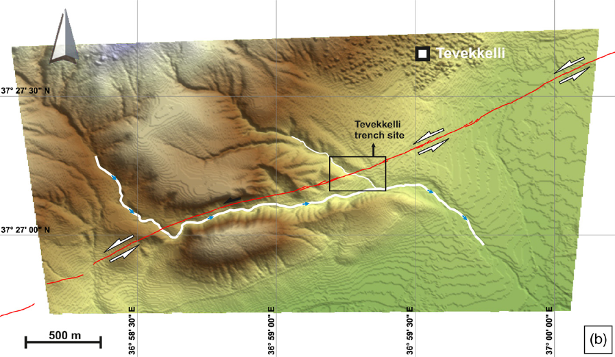
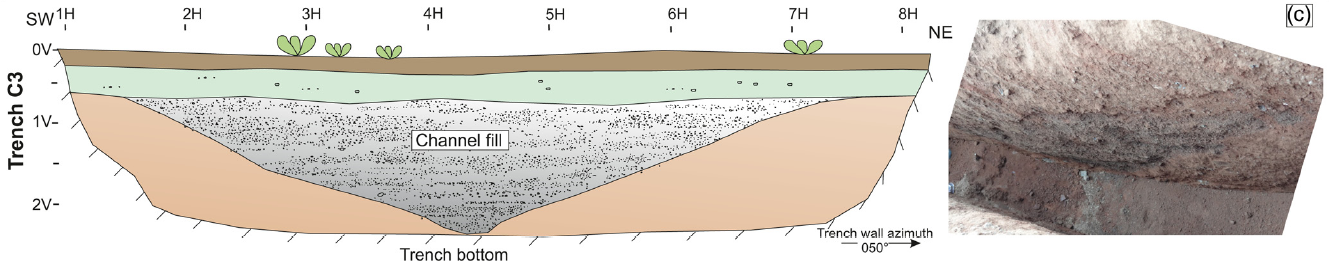
 did not identify a
similarly dated event in either of the two Balkar Trenches.
We investigate the palaeo earthquakes and slip rate on the Pazarcık segment of the East Anatolian Fault, which was involved in the surface rupture of the 6 February 2023 Pazarcık–Kahramanmaraş earthquake (MW 7.7) and provided insights into the long-term behaviour of this major continental fault. Palaeoseismological data from two trench sites reveal evidence for at least five surface ruptures in the Holocene Period. The historical earthquake of AD 1114 is verified at both trench sites but the following event of AD 1513 is identified at only one site. In addition, the age difference of the older events shows that historical activity is separated by much longer periods of relative quiescence that range from 500 to 1000 years, which suggests quasiperiodic earthquake occurrence on sub-segments of the Pazarcık segment. Our fault-parallel trenches revealed 101 ± 5 m offset in the last 18 kyr and 51 ± 1 m offset in the last 9 kyr on a buried stream channel and the actual channel of the same stream respectively. The correlation of the maximum and abandonment age of the channel with measured offsets revealed a 5.6 mm a-1 long-term slip rate of the fault.
The left lateral East Anatolian Fault (EAF) is one of the major transform faults of the Eastern Mediterranean region (Fig. 1a). The fault extends for about 550 km between Karlıova and Türkoğlu where it meets the North Anatolian Fault (NAF) to the NE and the Dead Sea Fault to the SW (Fig. 1b). The northward motion of the Arabian Plate is taken up by the EAF, together with the NAF, accommodating the westward extrusion of the Anatolian Block. The EAF is often considered a continuation of the Dead Sea Fault to the north where differential motion of the Arabian Peninsula relative to the African plate occurs (Fig. 1a) (McKenzie 1972; Şengör et al. 1985). In the most recent comprehensive study Duman and Emre (2013) studied the fault and divided it into seven segments based on fault step-overs, jogs or changes in fault strike between Karlıova and the Amik Basin. There are different opinions on the location of the intersection between the Dead Sea Fault and the EAF; some researchers (e.g. McKenzie 1970, 1972; Dewey et al. 1973; Şengör 1980; Jackson and McKenzie 1984; Hempton 1987; Barka and Kadinsky-Cade 1988; Kempler and Garfunkel 1991; Westaway and Arger 1996; Koçyiğit and Erol 2001; Yönlü et al. 2017) have suggested Türkoğlu whereas others (e.g. Allen 1969; Arpat and Şaroğlu 1975; Şengör et al. 1985; Kelling et al. 1987; Şaroğlu et al. 1992; Över et al. 2004; Duman and Emre 2013) have considered the Amik Basin as the location. The left lateral Karasu Fault extends along the western margin of the Karasu Valley between the two proposed intersection areas (i.e. from Türkoğlu in the north to the Amik Basin in the south). The Karasu Fault, thus, is known to transfer a significant amount of slip between the EAF and the Dead Sea Fault, although there is still discussion on which fault system the Karasu Fault belongs to.
The Pazarcık segment is the southernmost segment of the EAF before it intersects the Karasu Fault near Türkoğlu (Fig. 1b). The Pazarcık segment provides field evidence of sinistral displacement of stream beds by a few metres to kilometres, and faulted alluvial and colluvial deposits that extend for about 90 km between the Gölbası̧ Basin in the NE and Türkoğlu in the SW (Fig. 2). Between Gölbası̧ and Türkoğlu, the fault extends in pre-Quaternary rock units along most of its length. It cuts Quaternary deposits in limited areas in the Gölbası̧ Basin to the NE and around Türkoğlu in the SW. The general morphology of the fault is characterized by linear topography and large cumulative offsets in river channels (Fig. 2). It can be traced by fault-related geomorphological features such as offset stream channels, elongated and shutter ridges, linear saddles, scarps and depressions that are aligned on a single trace. To the NE a left bend near Gölbası̧ Lake forms the segment boundary between the Pazarcık and Erkenek segments (Fig. 2). The fault bounds the southeastern margin of the Gölbası̧ Basin and caused a cumulative offset on the Aksu Stream of 16.5 km (Yönlü et al. 2013). Further SW of the Gölbası̧ Basin, the fault extends in a high-relief area where three major stream channels, from south to north the Kısık, Koca and Gök streams, have recorded left lateral offsets of 4.4, 4.5 and 6.4 km, respectively (Fig. 2). Besides these large cumulative offsets, the majority of the stream channels show some evidence of left lateral offset on the fault trace. Near Kartal village, the fault makes a 1.5 km wide right bend, which causes uplift of the southern block owing to local transpression (Fig. 2). Based on the Kartal restraining bend, the Pazarcık segment can be separated into two geometrical subsections, namely the Gölbası̧ and Tevekkelli sub-sections (Fig. 2). It forms the contact of Cretaceous Neotethyan ophiolite and Quaternary alluvium between the towns of Çiğli and Küpelikız and follows the SE-facing escarpment. This is one of the areas where the fault disrupts the Quaternary deposits. Left laterally displaced stream channels in the Holocene sediments indicate the recent activity of the fault. Further SW, elongated ridges, offset stream beds and shutter ridges are the geomorphological evidence of active faulting. The morphological expression of the fault diminishes to the east of Türkoğlu where it enters the Aksu River alluvial plain (Fig. 2).
To retrieve the chronology of historical earthquakes that ruptured the surface on the Pazarcık segment, we excavated trenches at two sites in 2010 and 2011. Our trench sites are located near the NE and SW ends of the Pazarcık segment (Fig. 2). Our trenching attempts in a small depression near Kartal village in the middle of the segment did not provide sufficient information because of the thick, chaotic bedded, coarse sediments encountered in the trench. In our successful trench locations in the Gölbası Basin to the NE and at Tevekkelli to the SW, the Pazarcık–Kahramanmaraş 2023 earthquake ruptured the surface as a single line, indicating successful trench location selection.
The Balkar trench site is located in the Gölbası̧ Basin to the NE (Fig. 2). In this area the fault is characterized by pressure ridges, shutter ridges and left lateral offset stream beds indicating long-term activity. Our trench site lies to the NE of a fault-parallel elongated ridge, on farm fields gently sloping towards the NW (Fig. 3a).
The faulting is confined to a 1 m wide zone at the SE end of the trench. The repeated surface ruptures caused intense deformation along this narrow zone. Owing to numerous movements in the same narrow zone the traces of the past surface ruptures overlapped each other, making it impossible to distinguish different earthquake records. The trace of the most recent earthquake extended up to the base of the present soil (Fig. 4).
The Tevekkeli trench site is located in the southwestern part of the Pazarcık segment between Kocalar and Tevekkeli villages (Fig. 2), about 10 km NE of Türkoğlu. The EAF at this site is expressed as a single, geomorphologically well-defined strand. It is characterized by left laterally displaced stream channels and fault scarps, juxtaposing different rock units in the area. The cumulative 1.3 ± 0.2 km offset on an ephemeral stream (Fig. 3b and Supplementary material Fig. S1) indicates the long-term slip that developed on the fault at this locality. The offset stream geometry and linear shutter ridge in the area show that the fault motion occurs in a narrow zone, as shown by the 2023 surface rupture (Fig. 3b). Our fault mapping prior to the earthquake and the surface rupture mapping after the 2023 event support the view that the fault constitutes a single trace without additional secondary splays (Fig. 3b).
T1 is a fault-perpendicular trench excavated for accurate fault location and investigation of surface-rupturing events (Fig. 5). The 20 m long by 3 m deep trench was dug where a prominent narrow lineament and a low-relief scarp are present. It revealed well-stratified sedimentary units cut by discrete shear planes (Fig. 6).
The stream in this trench area flows across the fault zone on relatively flat topography (Fig. 5). The width of the stream bed varies between 3 and 6 m, and the active channel is about 1–2 m wide. The active channel bed comprises gravel and sand, transported from the elevated ground to the north. The channel was surveyed by differential (D-GPS in 2011 and the left lateral offset on the channel was recorded as 48 ± 1 m (Fig. 5). It should be noted that Karabacak et al. (2023) measured 3 m of left lateral coseismic offsets near this area after the 2023 Pazarcık–Kahramanmaraş earthquake, thus the total offset on the channel is 51 m at present. Actual channel geometry and total offset indicate that the stream channel has followed the same route for a long time. However, although it is difficult to generate new channel incisions in a flat topography following slip on the fault, a semi-flat topography favours the formation of at least one new stream channel.
Our trenches at the Balkar and Tevekkelli sites provided evidence of repeated surface rupturing events on the Pazarcık segment of the EAF. In addition to the 1513 and 1114 earthquakes, we found evidence of at least three, or possibly more, earlier surface ruptures during the past 10,000 years. The historical 1513 earthquake has been identified in the Tevekkelli trench but not in the Balkar trench in the Gölbası̧ Basin. This may suggest two possible scenarios.
Our three fault-parallel trenches on an abandoned and displaced stream channel have provided the first palaeoseismological slip rate estimate for the Pazarcık segment of the EAF. According to the age dating of buried stream deposits and the cumulative slip measured on the actual and abandoned stream channels, we measured 98 ± 5 and 48 ± 1 m offsets accumulated over a period of 17 800 and 9000 years, respectively. Considering the slip of the 6 February 2023 Pazarcık–Kahramanmaraş earthquake on top of the cumulative offsets measured in 2011 (Karabacak et al. 2023), 3 m offset was added to the cumulative slip after the earthquake. Therefore, the cumulative offset on the abandoned and actual stream is 101 ± 5 and 51 ± 1 m after the earthquake. The offset amounts and age dating revealed 5.6 ± 0.3 mm a−1 slip of the fault (Fig. 8). The fact that the slip rate for two different long periods is the same can be interpreted as indicating no significant change in the slip rate of the fault in the last 18 kyr.
We found evidence for at least five and possibly more surface ruptures over the past 10 kyr in our palaeoseismological trenches along the Pazarcık segment of the EAF. We have not identified evidence of the 1513 earthquake in our Balkar trench and we interpret that this event did not generate a surface rupture through the Gölbası̧ Basin. The 1513 earthquake rupture most probably was terminated to the NE by the Kartal restraining bend, which represents the most prominent change in the fault trend. The historical 1114 earthquake was recognized at both trench sites in the NE and SW parts of the segment. Considering the extensive damage reported across the Kahramanmaraş region in historical accounts and the rupture observed in the trenches, we suggest that the 1114 earthquake ruptured at least the entire Pazarcık segment and possibly produced a surface rupture of similar length to the 6 February 2023 Pazarcık–Kahramanmaraş earthquake.
Karabacak V., Akyuz, H.S., Kiyak, N.G., Altunel, E., Meghraoui, M., and Yönlü Ö. (2012)
Doğu Anadolu Fay Zonu’nun Gölbaşı (Adıyaman) ile Karataş (Adana) arasındaki kesiminin geç Kuvaterner aktivitesi
(Late Quaternary Seismic Activity on the East Anatolian Fault Zone between Gölbaşı (Adıyaman) and Karataş (Adana)),
Project 109Y043, March 2012, in Turkish
Yönlü Ö. and Karabacak V. (2023) Surface rupture history and 18 kyr long slip rate along the Pazarcık segment of the East Anatolian Fault,
Geological Society Journal, vol.181, no.1, pp. 1-11.
Yönlü Ö. and Karabacak V. (2023) Surface rupture history and 18 kyr long slip rate along the Pazarcık segment of the East Anatolian Fault,
Supplemental