Negev Rockfalls
- Fig. 1a Location Map
showing study area in relation to the Dead Sea fault (DSF) region from Matmon et al. (2005)
 Fig. 1a
DEM of Dead Sea fault (DSF) region showing the location of the study area. The DSF system is located between the parallel dashed lines.
Matmon et al. (2005) - Fig. 1b Aerial photo of the study area
of the study area from Matmon et al. (2005)
 Fig. 1b
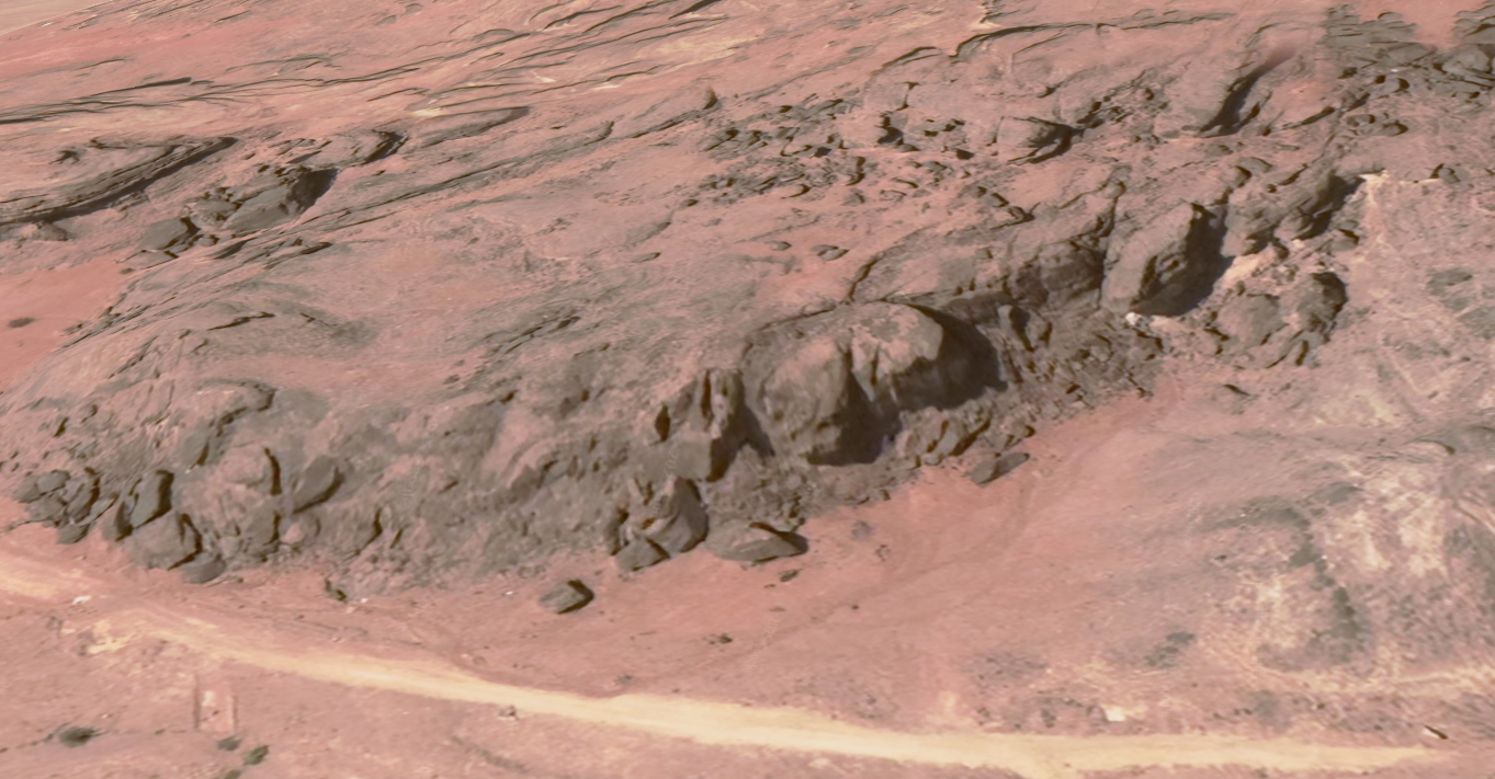
Aerial photo of the study area.
JW:
- E = 3rd Site
- C = Lower Valley
- D = Upper Valley
Matmon et al. (2005)
- Fig. 1a Location Map
showing study area in relation to the Dead Sea fault (DSF) region from Matmon et al. (2005)
Fig. 1a
DEM of Dead Sea fault (DSF) region showing the location of the study area. The DSF system is located between the parallel dashed lines.
Matmon et al. (2005) - Fig. 1b Aerial photo of the study area
of the study area from Matmon et al. (2005)
Fig. 1b
Aerial photo of the study area.
Matmon et al. (2005)
- Timna "Upper Valley"
Rockfalls Area in Google Earth
 Timna "Upper Valley" Rockfalls Area
click on image to explore this site on a new tab in Google Earth - Timna "Lower Valley"
Rockfalls Area in Google Earth
 Timna "Lower Valley" Rockfalls Area
click on image to explore this site on a new tab in Google Earth - Timna "Upper Valley"
Rockfalls Area on govmap.gov.il
 Timna "Upper Valley" Rockfalls Area
click on image to explore this site on a new tab in govmap.gov.il - Timna "Lower Valley"
Rockfalls Area on govmap.gov.il
 Timna "Lower Valley" Rockfalls Area
click on image to explore this site on a new tab in govmap.gov.il
- from Matmon et al. (2005)
 Fig. 1c
Lower Valley site. Photo taken looking towards the east. Source cliff is on the left. Person on left below boulder for scale. Cosmogenic age uncertainties include analytical errors, a 10% uncertainty in production rate, and sample-to-sample variation.
Matmon et al. (2005)
- from Matmon et al. (2005)
 Fig. 2
- Close-up of the detailed structure of the cliff and boulder faces. Small (1–5 cm) quartzite pebbles on the boulder face can be matched to cavities on the cliff face and vice versa. This perfect match enables identification of the exact location of the boulder before it was detached. The perfect match also indicates insignificant erosion since detachment. Rock pick for scale. Several cavities can be seen below the pencil.
- Photo of the boulder from which Timna 1 (in the center) was sampled. The relief of fracture ribs is apparent and indicates insignificant erosion since detachment of the boulder. Person for scale
- from Matmon et al. (2005)
 Fig. 3a
Cartoon showing the sequence of events that formed the present day morphology of the Lower Valley site.
- Initial valley before boulder formation
- After the formation of the first boulder pile, ~15 ka, the small valley was only partially blocked and sediment did not accumulate for several thousands of years
- The initial deposition of sediment, ~6.5 ka, is recorded by the lower unit in pit 1 upstream of the first pile of boulders
- The deposition of the "Closer Pile" at ~4 ka and the deposition of the second and third sedimentary units (recorded in the upper unit in pit 1 and in both units in pit 2)
- Thin dashed line — the original position of the valley wall
- Thick dashed line — the position of the valley wall after the deposition of the "Farther Pile"
Matmon et al. (2005)
- from Matmon et al. (2005)
 Fig. 1d
Upper Valley site. Photo taken looking towards the south. People on boulder for scale. Cosmogenic age uncertainties include analytical errors, a 10% uncertainty in production rate, and sample-to-sample variation.
Matmon et al. (2005)
- from Matmon et al. (2005)
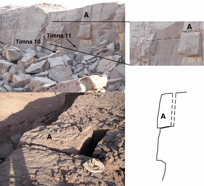 Fig. 4
- Boulder pile at the "Upper Valley" location. Dated boulder is marked by dashed lines. Bedrock block (5 m x 1.5 m x 2 m; marked by the letter A) is bounded by fractures.
- The back fracture of block A is open ~30 cm and suggests the movement of the boulder in the direction of the cliff’s free face.
- Cross-section through the bedrock block perpendicular to the cliff face shows the gentle angle of the base fracture of the block. This angle (LT 10°) indicates that movement requires ground acceleration
- from Matmon et al. (2005)
 Fig. 1e
Third site location. Single boulders at increasing distance from source cliff. The degree of weathering increases with distance from the cliff. The age of boulder TMN-9 was not determined, however, its distance from the cliff (4 m) helps estimate the average rate of retreat of the cliff. Person near boulder TMN-8 for scale. Cosmogenic age uncertainties include analytical errors, a 10% uncertainty in production rate, and sample-to-sample variation.
Matmon et al. (2005)
- from Matmon et al. (2005)
 Fig. 3b
Age relations between cosmogenic nuclide and OSL samples. The correlation between the OSL samples is not certain apart from the significant difference between the lower sedimentary unit in pit 1 and the upper sedimentary unit in pit 2. In the "Closer Pile", only sample Timna 3 can be statistically old enough to be older than the sediments and represent the time of boulder detachment. The dashed horizontal lines indicate the most probable ages of events that could have caused the detachment of the boulders sampled by Timna 1, Timna 2, Timna 10, and TMN-8.
Matmon et al. (2005)
- Fig. 1 Location Map
for Rockfall sites SH1, SH2, SH4, and SH10 in the vicinity of Nahal Shehoret from Rinat et al. (2014)
 Fig. 1
General location of the research area in the eastern Mediterranean (black star) and an aerial orthophoto of the study sites in the vicinity of Nahal Shehoret. All sites are located within a few 100s of meters of each other.
Rinat et al. (2014)
- Fig. 1 Location Map
for Rockfall sites SH1, SH2, SH4, and SH10 in the vicinity of Nahal Shehoret from Rinat et al. (2014)
Fig. 1
General location of the research area in the eastern Mediterranean (black star) and an aerial orthophoto of the study sites in the vicinity of Nahal Shehoret. All sites are located within a few 100s of meters of each other.
Rinat et al. (2014)
- from Rinat et al. (2014)


 Left Pre-fall Setting (Fig. 5)
- Crosses represent sample locations
- Stars represent samples projected to the cross section plain
- Pre-fall depths and distance from cliff wall can be seen in the figure
OSL samples, marked with black dots, were collected from post-fall sediments that abut the boulders or accumulated underneath boulders.
Right TCN samples (Fig. 2a)
TCN samples were collected from the bedrock at the upper surface above each rockfall site (samples RF), from the rockfall scar on each cliff (samples BR), and from exposed boulder faces. Paired samples in each site are marked with identical polygons.
Rinat et al. (2014)
- from Rinat et al. (2014)
 Fig. 4
Schematic cross-section across site SH10. Remnants of alluvial sediments (named hereT-1and T-2) suggest earlier coverage and burial of the site by early to middle Pleistocene terraces of Nahal Shehoret. The T-1 and T-2 terraces share similar characteristics such as sediment type, appearance, and roughness. Connecting the two terraces suggests minimum sediment coverage above the site of ~15 m.
Rinat et al. (2014)
- from Rinat et al. (2014)
 Fig. 3
Site SH10 and two of its ~75 m3 matching boulders, located at the foot of their source cliff; note a person (marked by a circle) for scale. The once-connected boulders match perfectly, as seen by matching lithoclasts found on the presently exposed faces (b, c). Marks like these enable the matching of faces on different boulders and on the cliff, ensure sampling from the same pre-detachment locations and provide the necessary evidence for negligible erosion.
Rinat et al. (2014)
- from Rinat et al. (2014)
 Fig. 10
- Evidences for Holocene seismic events from paleoseismic records along the length of the DSF. The time interval, represented by a gray box, is determined by the maximum age range of the four dated boulder piles in this study. Possible seismic events are recorded at ~5 ka along the entire length of the Dead Sea rift and its main branch the Carmel fault.
- Locations of the sites mentioned in (a)
Matmon et al. (2005:811) used the combined exposure ages determined from
cosmogenic isotopes and OSL ages
from three rockfall sites at Timna
to suggest several boulder detachment events
which they surmise were caused by earthquakes.
The oldest event (31.0±4.9 ka) was recorded only in one of the three sites
(named the third site). The next oldest event apparently caused rockfalls in all three Timna sites.
A summary of the dates for the next oldest event is summarized in the Table below:
| Age | Site | Comments |
|---|---|---|
| 15.1±3.4 ka | Upper Valley | Samples Timna-10 and Timna-11 |
| 15.1±2.1 ka | Lower Valley | Sample Timna-1 |
| 13.9±4.8 ka | Third Site |
|
Many processes, including tectonic, climatic, and environmental factors can cause rockslides [40]. Many of these factors can be eliminated in the case of rockslides in Timna. Snowmelt, freeze and thaw effects, ground water seepage, and tree root wedging can be ruled out due to the hot and hyperarid conditions in the area. Although rain storms and the result ing expansion of clay and salt particles in cracks is a plausible mechanism, we would expect boulders to detach one at a time rather than in groups that form large piles as is the case in Timna. Furthermore, the frequency of clay and salt wetting events is not high enough to generate proper stress in the fractures to allow boulder release. Several observations, mainly the large size of the boulders (many of the boulders have at least one dimension longer then 5 meters) and the agreement in ages of boulder piles in the sampling locations suggest that each pile of boulders was detached from its source cliff in a single event. The proximity of Timna to the DSF, where GT M6 earthquakes are common, suggests that ground shaking due to seismic events is the most likely cause for the Timna boulder slides.
A significant observation at the "Upper Valley" site supports the assumption that earthquakes are the major trigger of rock falls in the Timna area. A big block (5 m x 1.5 m x 2 m, point A in Fig. 4) is bounded by fractures. The fracture at the back of the boulder is about 30 cm wide and indicates the movement of the boulder in the direction of the cliff’s free face. The fracture at the base of the boulder is tilted towards the free face at an angle of less than 10° (Fig. 4). This angle is much lower than the maximum angle of repose of sandstone even when accounting for pore pressure effects [41]. Hence, the sliding of the block requires ground acceleration in a direction that is perpendicular to the cliff face to allow the opening of the back fracture. Ground acceleration in this desired direction is achieved by earthquakes generated along the adjacent segment of the DSF.
Fig. 4- Boulder pile at the "Upper Valley" location. Dated boulder is marked by dashed lines. Bedrock block (5 m x 1.5 m x 2 m; marked by the letter A) is bounded by fractures.
- The back fracture of block A is open ~30 cm and suggests the movement of the boulder in the direction of the cliff’s free face.
- Cross-section through the bedrock block perpendicular to the cliff face shows the gentle angle of the base fracture of the block. This angle (LT 10°) indicates that movement requires ground acceleration
Rock falls are sensitive recorders of strong ground motion resulting from earthquakes [42]. Synchronous rock falls may indicate the occurrence of past earthquakes and rock fall timing may constrain earthquake recurrence intervals and magnitude. The relation between seismic events and the formation of boulders in rock falls is well established. A worldwide correlation between landslide size and distribution and variables such as earthquake magnitude and the specific ground-motion characteristics was determined by [43]. A coseismic lichenometry model was developed in New Zealand following the discovery that lichens growing on rocky hill slopes recorded synchronous pulses of rock falls generated by historical earthuakes. The lichenometry model was used to date boulders and rock falls associated with earthquakes [44–48].
Current measurements in the southern Arava Valley along the DSF system show no seismic activity [49]. However, historical evidence documents several large seismic events [50,51]. Paleoseismic studies in the southern Arava Valley suggest that late Pleistocene earthquakes ranged in magnitude between 6.7 and 7.1 and the average recurrence interval was 2.8±0.7 ky [52]. These studies indicate that Holocene earthquakes were more frequent, with an average recurrence interval of 1.2±0.3 ky, but with smaller magnitudes that ranged between M5.9 and M6.7. Several studies in the northern Arava Valley also suggest frequent Holocene and late Pleistocene seismic activity [4,50,53–56].
The time interval between the three boulder forming events recorded in this study is much longer than the recurrence interval of GT M6 earth quakes in the region. However, this discrepancy does not rule out seismic motion as the mechanism for the boulder formation. A possible explanation is that the interval between boulder forming events represents the time that is necessary for fractures to develop to the point of minimum friction between boulders and bedrock. During this time, earthquakes occur and gradually enhance the open ing of fractures that surround boulders. Once these fractures are sufficiently developed, the next major earthquake releases the boulders. The spacing between the fractures determines the thickness of collapsed wall during each rock fall event and the level of sandstone lithification determines the resistance of the fresh exposed rock to weathering. Continued study of additional rock piles at Timna may help to better constrain the temporal frequency of rock fall events, and improve the correlation between rock falls and earthquakes.
Matmon et al. (2005:811) used the combined exposure ages determined from
cosmogenic isotopes and OSL ages
from three rockfall sites at Timna
to suggest several boulder detachment events
which they surmise were caused by earthquakes.
They only dated one event in the Holocene. This event was dated to 3.7±0.8 ka based on
the "Closer Pile" in the Lower Valley.
Agnon (2014:232) discussed the same event but listed a slightly different date - 32-4.5 ka.
Many processes, including tectonic, climatic, and environmental factors can cause rockslides [40]. Many of these factors can be eliminated in the case of rockslides in Timna. Snowmelt, freeze and thaw effects, ground water seepage, and tree root wedging can be ruled out due to the hot and hyperarid conditions in the area. Although rain storms and the result ing expansion of clay and salt particles in cracks is a plausible mechanism, we would expect boulders to detach one at a time rather than in groups that form large piles as is the case in Timna. Furthermore, the frequency of clay and salt wetting events is not high enough to generate proper stress in the fractures to allow boulder release. Several observations, mainly the large size of the boulders (many of the boulders have at least one dimension longer then 5 meters) and the agreement in ages of boulder piles in the sampling locations suggest that each pile of boulders was detached from its source cliff in a single event. The proximity of Timna to the DSF, where GT M6 earthquakes are common, suggests that ground shaking due to seismic events is the most likely cause for the Timna boulder slides.
A significant observation at the "Upper Valley" site supports the assumption that earthquakes are the major trigger of rock falls in the Timna area. A big block (5 m x 1.5 m x 2 m, point A in Fig. 4) is bounded by fractures. The fracture at the back of the boulder is about 30 cm wide and indicates the movement of the boulder in the direction of the cliff’s free face. The fracture at the base of the boulder is tilted towards the free face at an angle of less than 10° (Fig. 4). This angle is much lower than the maximum angle of repose of sandstone even when accounting for pore pressure effects [41]. Hence, the sliding of the block requires ground acceleration in a direction that is perpendicular to the cliff face to allow the opening of the back fracture. Ground acceleration in this desired direction is achieved by earthquakes generated along the adjacent segment of the DSF.
Fig. 4- Boulder pile at the "Upper Valley" location. Dated boulder is marked by dashed lines. Bedrock block (5 m x 1.5 m x 2 m; marked by the letter A) is bounded by fractures.
- The back fracture of block A is open ~30 cm and suggests the movement of the boulder in the direction of the cliff’s free face.
- Cross-section through the bedrock block perpendicular to the cliff face shows the gentle angle of the base fracture of the block. This angle (LT 10°) indicates that movement requires ground acceleration
Rock falls are sensitive recorders of strong ground motion resulting from earthquakes [42]. Synchronous rock falls may indicate the occurrence of past earthquakes and rock fall timing may constrain earthquake recurrence intervals and magnitude. The relation between seismic events and the formation of boulders in rock falls is well established. A worldwide correlation between landslide size and distribution and variables such as earthquake magnitude and the specific ground-motion characteristics was determined by [43]. A coseismic lichenometry model was developed in New Zealand following the discovery that lichens growing on rocky hill slopes recorded synchronous pulses of rock falls generated by historical earthuakes. The lichenometry model was used to date boulders and rock falls associated with earthquakes [44–48].
Current measurements in the southern Arava Valley along the DSF system show no seismic activity [49]. However, historical evidence documents several large seismic events [50,51]. Paleoseismic studies in the southern Arava Valley suggest that late Pleistocene earthquakes ranged in magnitude between 6.7 and 7.1 and the average recurrence interval was 2.8±0.7 ky [52]. These studies indicate that Holocene earthquakes were more frequent, with an average recurrence interval of 1.2±0.3 ky, but with smaller magnitudes that ranged between M5.9 and M6.7. Several studies in the northern Arava Valley also suggest frequent Holocene and late Pleistocene seismic activity [4,50,53–56].
The time interval between the three boulder forming events recorded in this study is much longer than the recurrence interval of GT M6 earth quakes in the region. However, this discrepancy does not rule out seismic motion as the mechanism for the boulder formation. A possible explanation is that the interval between boulder forming events represents the time that is necessary for fractures to develop to the point of minimum friction between boulders and bedrock. During this time, earthquakes occur and gradually enhance the open ing of fractures that surround boulders. Once these fractures are sufficiently developed, the next major earthquake releases the boulders. The spacing between the fractures determines the thickness of collapsed wall during each rock fall event and the level of sandstone lithification determines the resistance of the fresh exposed rock to weathering. Continued study of additional rock piles at Timna may help to better constrain the temporal frequency of rock fall events, and improve the correlation between rock falls and earthquakes.