Baris, Kurucaova, and Sürgü-East Trenches
 General Vicinity of Baris, Kurucaova, and Sürgü-East Trenches
click on image to explore this site on a new tab in Google Earth
- Fig. 1 East Anatolian Active
Fault Zone Map from Balkaya et al. (2023)
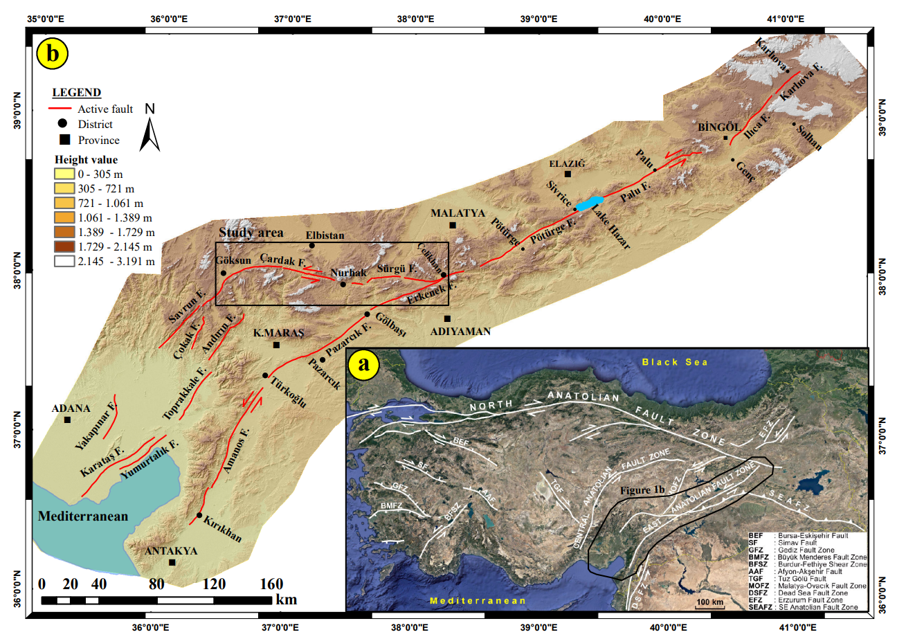 Fig. 1
- Location of the EAFZ on an active fault map of Türkiye
- The geometry and segmentation of the EAFZ and location of the study area (simplified from Duman and Emre (2013)
Balkaya et al. (2023) - Fig. 2 Simplified geological
map of the Sürgü Fault Area from Balkaya et al. (2023)
 Fig. 2
Simplified geological map of the study area
(compiled from 1/100,000 scale sheets of MTA geology database (Bedi and Yusufoğlu, 2018; Çoban and Dalkılıç, 2018; Sümengen, 2014a and 2014b; Usta et al., 2018))
Balkaya et al. (2023) - Fig. 2 Simplified geological
map of the Cardak Fault Area from Balkaya et al. (2023)
 Fig. 2
Simplified geological map of the study area
(compiled from 1/100,000 scale sheets of MTA geology database (Bedi and Yusufoğlu, 2018; Çoban and Dalkılıç, 2018; Sümengen, 2014a and 2014b; Usta et al., 2018))
Balkaya et al. (2023) - Fig. 3 Physiography of the
Sürgü Fault and its segmentation into four sections (Sürgü-1 to -4) from Balkaya et al. (2023)
 Fig. 3
- Physiography of the Sürgü Fault and its segmentation into four sections (Sürgü-1 to -4)
- the sinistral offset of Tatlar creek on DEM
Balkaya et al. (2023) - Fig. 3b Sinistral offset of
Tatlar creek on DEM from Balkaya et al. (2023)
 Fig. 3b
the sinistral offset of Tatlar creek on DEM
Balkaya et al. (2023) - Fig. 4 Sürgü Fault between
Kurucaova and Sürgü Dam from Balkaya et al. (2023)
 Fig. 4
The Sürgü Fault between Kurucaova and Sürgü Dam
Balkaya et al. (2023) - Fig. 6 Physiography of
the Çardak Fault segmented into two sections from Balkaya et al. (2023)
 Fig. 6
Physiography of the Çardak Fault segmented into two sections
Balkaya et al. (2023) - Fig. 1 East Anatolian Fault
Map from Duman et al. (2020)

Fig. 1
East Anatolian fault between Karlıova and Gulf of İskenderun; Major fault zones in the vicinity plotted in black (simplified from Emre et al. 2018). Inset map shows the active tectonic framework of the Eastern Mediterranean region (from Emre et al. 2018). Dashed polygon indicates the study area. Abbreviations:
- NAFZ North Anatolian fault zone
- EAFZ East Anatolian fault zone
- NS Northern strand
- SS Southern strand
- PE Pontic Escarpment
- LC Lesser Caucasus
- GC Great Caucasus
- WAEP West Anatolian Extensional Provence
- CAP Central Anatolian Provence
- WAEP Eastern Anatolian Compressional Provence
- DSFZ Dead Sea fault zone
- HA Hellenic arc
- PFFZ Palmyra fold and fault zone
- CA Cyprian arc
- SATZ Southeast Anatolian thrust zone
- SMFS Sürgü–Misis fault system
- MKF Misis–Kyrenia fault
- MF Malatya fault
- SF Sarız fault
- EF Ecemiş fault
- DF Deliler fault
- Karlıova fault segment
- Ilıca fault segment
- Palu fault segment
- Pütürge fault segment
- Erkenek fault segment
- Pazarcık fault segment
- Amanos fault segment
- Sürgü fault segment
- Çardak fault segment
- Savrun fault segment
- Çokak fault segment
- Toprakkale fault segment
- Karataş fault segment
- Yumurtalık fault segment
- Düziçi–Osmaniye fault zone;
- Misis fault segment
- Engizek fault zone
- Maraş fault zone
- Fig. 2 Historical and
Instrumental earthquakes along the western Sürgü–Misis fault (SMF) system from Duman et al. (2020)

Fig. 2
Distribution of both historical (a) and instrumental (b) earthquakes along the western segments of Sürgü–Misis fault (SMF) system around the Gulf of İskenderun (simplified from Duman and Emre, 2013). Thick red and black lines indicate the SMF system (north strand) and south strand of the East Anatolian fault zone, respectively. The locations of historical earthquakes are from Tan et al. (2008), Ambraseys (1988), Ambraseys and Jackson (1998) and Başarır Baştürk et al. (2017). The instrumental data are from Kalafat et al. (2011), Aktar et al. (2000), Ergin et al. (2004) and Kadirioğlu et al. (2018). The focal mechanisms are from Kılıç et al. (2017). The letter inside boxes refers to the source for the historical earthquakes as given by Tan et al. (2008).
- ST Shebalin and Tatevossian (1997)
- KU Kondorskaya and Ulomov (1999)
- EG Guidoboni et al. (1994)
- EG2 Guidoboni and Comastri (2005)
- AM Ambraseys (1988)
- AJ Ambraseys and Jackson (1998)
- MFS Misis fault segment
- KFS Karataş fault segment
- YFS Yumurtalık fault segment
- DİFZ Düziçi–İskenderun fault zone
- AFS Amanos fault segment
- YEFS Yesemek fault segment
- AFFS Afrin fault segment
- NFZ Narlı fault zone
- MFZ Maraş fault zone
- EFZ Engizek fault zone
- ÇOFS Çokak fault segment
- SAFS Savrun fault segment
- TFS Toprakkale fault segment
- ÇFS Çardak fault segment
- SFS, Sürgü fault segment
Duman et al. (2020)
- Fig. 1 East Anatolian Active
Fault Zone Map from Balkaya et al. (2023)
Fig. 1
- Location of the EAFZ on an active fault map of Türkiye
- The geometry and segmentation of the EAFZ and location of the study area (simplified from Duman and Emre (2013)
Balkaya et al. (2023) - Fig. 2 Simplified geological
map of the Sürgü Fault Area from Balkaya et al. (2023)
Fig. 2
Simplified geological map of the study area
(compiled from 1/100,000 scale sheets of MTA geology database (Bedi and Yusufoğlu, 2018; Çoban and Dalkılıç, 2018; Sümengen, 2014a and 2014b; Usta et al., 2018))
Balkaya et al. (2023) - Fig. 2 Simplified geological
map of the Cardak Fault Area from Balkaya et al. (2023)
Fig. 2
Simplified geological map of the study area
(compiled from 1/100,000 scale sheets of MTA geology database (Bedi and Yusufoğlu, 2018; Çoban and Dalkılıç, 2018; Sümengen, 2014a and 2014b; Usta et al., 2018))
Balkaya et al. (2023) - Fig. 3 Physiography of the
Sürgü Fault and its segmentation into four sections (Sürgü-1 to -4) from Balkaya et al. (2023)
Fig. 3
- Physiography of the Sürgü Fault and its segmentation into four sections (Sürgü-1 to -4)
- the sinistral offset of Tatlar creek on DEM
Balkaya et al. (2023) - Fig. 3b Sinistral offset of
Tatlar creek on DEM from Balkaya et al. (2023)
Fig. 3b
the sinistral offset of Tatlar creek on DEM
Balkaya et al. (2023) - Fig. 4 Sürgü Fault between
Kurucaova and Sürgü Dam from Balkaya et al. (2023)
Fig. 4
The Sürgü Fault between Kurucaova and Sürgü Dam
Balkaya et al. (2023) - Fig. 6 Physiography of
the Çardak Fault segmented into two sections from Balkaya et al. (2023)
Fig. 6
Physiography of the Çardak Fault segmented into two sections
Balkaya et al. (2023) - Fig. 1 East Anatolian Fault
Map from Duman et al. (2020)
Fig. 1
East Anatolian fault between Karlıova and Gulf of İskenderun; Major fault zones in the vicinity plotted in black (simplified from Emre et al. 2018). Inset map shows the active tectonic framework of the Eastern Mediterranean region (from Emre et al. 2018). Dashed polygon indicates the study area. Abbreviations:
- NAFZ North Anatolian fault zone
- EAFZ East Anatolian fault zone
- NS Northern strand
- SS Southern strand
- PE Pontic Escarpment
- LC Lesser Caucasus
- GC Great Caucasus
- WAEP West Anatolian Extensional Provence
- CAP Central Anatolian Provence
- WAEP Eastern Anatolian Compressional Provence
- DSFZ Dead Sea fault zone
- HA Hellenic arc
- PFFZ Palmyra fold and fault zone
- CA Cyprian arc
- SATZ Southeast Anatolian thrust zone
- SMFS Sürgü–Misis fault system
- MKF Misis–Kyrenia fault
- MF Malatya fault
- SF Sarız fault
- EF Ecemiş fault
- DF Deliler fault
- Karlıova fault segment
- Ilıca fault segment
- Palu fault segment
- Pütürge fault segment
- Erkenek fault segment
- Pazarcık fault segment
- Amanos fault segment
- Sürgü fault segment
- Çardak fault segment
- Savrun fault segment
- Çokak fault segment
- Toprakkale fault segment
- Karataş fault segment
- Yumurtalık fault segment
- Düziçi–Osmaniye fault zone;
- Misis fault segment
- Engizek fault zone
- Maraş fault zone
- Fig. 2 Historical and
Instrumental earthquakes along the western Sürgü–Misis fault (SMF) system from Duman et al. (2020)
Fig. 2
Distribution of both historical (a) and instrumental (b) earthquakes along the western segments of Sürgü–Misis fault (SMF) system around the Gulf of İskenderun (simplified from Duman and Emre, 2013). Thick red and black lines indicate the SMF system (north strand) and south strand of the East Anatolian fault zone, respectively. The locations of historical earthquakes are from Tan et al. (2008), Ambraseys (1988), Ambraseys and Jackson (1998) and Başarır Baştürk et al. (2017). The instrumental data are from Kalafat et al. (2011), Aktar et al. (2000), Ergin et al. (2004) and Kadirioğlu et al. (2018). The focal mechanisms are from Kılıç et al. (2017). The letter inside boxes refers to the source for the historical earthquakes as given by Tan et al. (2008).
- ST Shebalin and Tatevossian (1997)
- KU Kondorskaya and Ulomov (1999)
- EG Guidoboni et al. (1994)
- EG2 Guidoboni and Comastri (2005)
- AM Ambraseys (1988)
- AJ Ambraseys and Jackson (1998)
- MFS Misis fault segment
- KFS Karataş fault segment
- YFS Yumurtalık fault segment
- DİFZ Düziçi–İskenderun fault zone
- AFS Amanos fault segment
- YEFS Yesemek fault segment
- AFFS Afrin fault segment
- NFZ Narlı fault zone
- MFZ Maraş fault zone
- EFZ Engizek fault zone
- ÇOFS Çokak fault segment
- SAFS Savrun fault segment
- TFS Toprakkale fault segment
- ÇFS Çardak fault segment
- SFS, Sürgü fault segment
Duman et al. (2020)
- General Vicinity of Sürgü–Çardak
Fault System in Google Earth
General Vicinity of Baris, Kurucaova, and Sürgü-East Trenches
click on image to explore this site on a new tab in Google Earth
 Fig. 7
Google Earth image showing the 70-m stream offset through Barış village. White arrows indicate the sinistral deflection emphasized by the stream bed.
Balkaya et al. (2023)
 Fig. 16
Location of the Barış trenches on the geological map of the eastern section of the Çardak Fault
Balkaya et al. (2023)
 Fig. 18
Log of the east wall of the Barış-1 trench (see Figure 16 for trench location).
Balkaya et al. (2023)
 Fig. 19
The traces of bedrock faults (red dashed lines) at meters -3 to -4 on the eastern wall of the Barış-1 trench
Balkaya et al. (2023)
 Fig. 20
The fault strands (red dashed lines) between the meters-15 and -17 on the eastern wall of the Barış-1 trench
Balkaya et al. (2023)
 Fig. 17
The fault scarp along the Çardak Fault, west of the Barış trenches (looking towards SW)
Balkaya et al. (2023)
 Fig. 8
Topographic elevation difference and stream offset in Barış village (looking towards SE). The yellow dashed line shows the fault line, the blue dashed lines show the offset on channel edges, and the white arrows show the elevation difference.
Balkaya et al. (2023)
 Fig. 24
The graphic shows calibration of the collected samples from the Barış-1 and Barış-2 trenches using OxCal v4.4.4 and the time interval of earthquakes detected on the Çardak Fault (Bronk Ramsey, 2017; Reimer et al., 2020). BB6, BB7 and BB8 represent the sample numbers of samples taken from the Barış-1 trench, yet BB2 and BB4 indicate the sample numbers taken from Barış-2 trench
Balkaya et al. (2023)
 Table 3
The 14C dating results from paleoseismic sites on Çardak Fault
Balkaya et al. (2023)
Fig. 7Google Earth image showing the 70-m stream offset through Barış village. White arrows indicate the sinistral deflection emphasized by the stream bed.
Balkaya et al. (2023)
Fig. 16Location of the Barış trenches on the geological map of the eastern section of the Çardak Fault
Balkaya et al. (2023)
 Fig. 21
Log of the east wall of the Barış-2 trench (see Figure 16 for trench location).
Balkaya et al. (2023)
 Fig. 22
The fault strands between meters -18 and -21 of the eastern wall of the Barış-2 trench. The red dashed lines show the faults.
Balkaya et al. (2023)
Fig. 17The fault scarp along the Çardak Fault, west of the Barış trenches (looking towards SW)
Balkaya et al. (2023)
Fig. 8Topographic elevation difference and stream offset in Barış village (looking towards SE). The yellow dashed line shows the fault line, the blue dashed lines show the offset on channel edges, and the white arrows show the elevation difference.
Balkaya et al. (2023)
Fig. 24The graphic shows calibration of the collected samples from the Barış-1 and Barış-2 trenches using OxCal v4.4.4 and the time interval of earthquakes detected on the Çardak Fault (Bronk Ramsey, 2017; Reimer et al., 2020). BB6, BB7 and BB8 represent the sample numbers of samples taken from the Barış-1 trench, yet BB2 and BB4 indicate the sample numbers taken from Barış-2 trench
Balkaya et al. (2023)
Table 3The 14C dating results from paleoseismic sites on Çardak Fault
Balkaya et al. (2023)
 Fig. 10
Trench locations in the eastern part of the Sürgü Fault
Balkaya et al. (2023)
 Fig. 12
Log of the west wall of the Kurucaova trench (see Figure 10 for trench location)
Balkaya et al. (2023)
Fig. 13The fault (red dashed line) at meter-9 on the western wall of the Kurucaova trench.
Balkaya et al. (2023)
 Fig. 11
General view of Kurucaova trench site (looking towards SW). Red arrows indicate fault
Balkaya et al. (2023)
 Fig. 5
The Sürgü Fault in exposure, cutting Late Quaternary deposits in Sürgü district (view to west)
Balkaya et al. (2023)
 Fig. 23
The graphic shows calibration of the collected samples from the Sürgü-East and Kurucaova trenches using OxCal v4.4.4 and the time interval of earthquakes detected on the Sürgü Fault (Bronk Ramsey, 2017; Reimer et al., 2020). KC1, KB5 and KB6 represent the sample numbers of samples taken from the Kurucaova trench, yet B1, B2 and B3 indicate the sample numbers taken from Sürgü-East trench.
Balkaya et al. (2023)
 Table 2
The 14C dating results from paleoseismic sites on Sürgü Fault
Balkaya et al. (2023)
Fig. 10Trench locations in the eastern part of the Sürgü Fault
Balkaya et al. (2023)
 Fig. 14
Log of the east wall of the Sürgü-East trench (see Figure 10 for trench location).
Balkaya et al. (2023)
 Fig. 15
The view of infill on the east wall of the Sürgü-East trench and the locations of the samples..
Balkaya et al. (2023)
Fig. 5The Sürgü Fault in exposure, cutting Late Quaternary deposits in Sürgü district (view to west)
Balkaya et al. (2023)
Fig. 23The graphic shows calibration of the collected samples from the Sürgü-East and Kurucaova trenches using OxCal v4.4.4 and the time interval of earthquakes detected on the Sürgü Fault (Bronk Ramsey, 2017; Reimer et al., 2020). KC1, KB5 and KB6 represent the sample numbers of samples taken from the Kurucaova trench, yet B1, B2 and B3 indicate the sample numbers taken from Sürgü-East trench.
Balkaya et al. (2023)
Table 2The 14C dating results from paleoseismic sites on Sürgü Fault
Balkaya et al. (2023)
- Supplementary Figure - Surface
ruptures from 6 Feb. 2023 Ekinözü earthquake in the vicnity of the Baris Trenches from Balkaya et al. (2023)
 Supplementary Figure
- The trace of the surface rupture formed after the 6 February 2023 earthquake in the west of Barış village
- Trace of the surface rupture that offset the Barış-1 trench and the adjacent field border by 5.4 ± 0.30 m left-laterally
- 6.5 ± 0.25 m offset in a small channel at 80 m east of the Barış-2 trench (looking towards south). Red arrows show offset at the small channel.
Balkaya et al. (2023)
- Supplementary Figure -
Surface ruptures from 6 Feb. 2023 Ekinözü earthquake in the vicnity of the Baris Trenches from Balkaya et al. (2023)
Supplementary Figure
- The trace of the surface rupture formed after the 6 February 2023 earthquake to the west of Barış village
- Trace of the surface rupture that offset the Barış-1 trench and the adjacent field border by 5.4 ± 0.30 m left-laterally
- 6.5 ± 0.25 m offset in a small channel 80 m east of the Barış-2 trench (looking towards south). Red arrows show offset of the small channel.
Balkaya et al. (2023)