Teleilat Ghassul
 Teleilat el-Ghassul
click on image to open a slightly high res magnifiable image in a new tab
APAAME
APAAME_19980517_
RHB-0044.tif
| Transliterated Name | Source | Name |
|---|---|---|
| Teleilat Ghassul | Arabic | |
| Tuleilat el-Ghassul | Arabic | |
| Tulaylât al-Ghassûl | Arabic |
- Map 1 - Late Neolithic
Sites of the Levant from Lovell (2001)
 Map 1
Map 1
Late Neolithic Sites of the Levant
Lovell (2001) - Map 2 - Early and Middle
Chalcolithic Sites of the Levant from Lovell (2001)
 Map 2
Map 2
Early and Middle Chalcolithic Sites of the Levant
Lovell (2001) - Map 3 - Late Chalcolithic
Sites of the Levant from Lovell (2001)
 Map 3
Map 3
Late Chalcolithic Sites of the Levant
Lovell (2001) - Teleilat Ghassul in Google Earth
 Teleilat Ghassul
click on image to explore this site on a new tab in Google Earth
- Map 1 - Late Neolithic
Sites of the Levant from Lovell (2001)
Map 1
Late Neolithic Sites of the Levant
Lovell (2001) - Map 2 - Early and Middle
Chalcolithic Sites of the Levant from Lovell (2001)
Map 2
Early and Middle Chalcolithic Sites of the Levant
Lovell (2001) - Map 3 - Late Chalcolithic
Sites of the Levant from Lovell (2001)
Map 3
Late Chalcolithic Sites of the Levant
Lovell (2001)
- Fig. 1.1
Plan of Teleilat Ghassul before excavation by PBI from Lovell (2001)
 Fig. 1.1
Plan of Teleilat Ghassul made before excavation by PBI
(after Mallon et. al. 1934: fig. 11)
(NB The T numbers are tells, the S numbers are soundings made before major excavations)
Lovell (2001) - Fig. 3.1a
Plan of Teleilat Ghassul showing excavated areas from Lovell (2001)
 Fig. 3.1a
Plan of Teleilat Ghassul showing excavated areas
Lovell (2001)
- Fig. 1.1
Plan of Teleilat Ghassul before excavation by PBI from Lovell (2001)
Fig. 1.1
Plan of Teleilat Ghassul made before excavation by PBI
(after Mallon et. al. 1934: fig. 11)
(NB The T numbers are tells, the S numbers are soundings made before major excavations)
Lovell (2001) - Fig. 3.1a
Plan of Teleilat Ghassul showing excavated areas from Lovell (2001)
Fig. 3.1a
Plan of Teleilat Ghassul showing excavated areas
Lovell (2001)
- Fig. 3.1a
Plan of Teleilat Ghassul showing excavated areas from Lovell (2001)
Fig. 3.1a
Plan of Teleilat Ghassul showing excavated areas
Lovell (2001) - Fig. 3.1b
Plan of Area A showing the position of Bourke's soundings from Lovell (2001)
 Fig. 3.1b
Plan of Teleilat Ghassul, Area A showing the position of Bourke's soundings
Lovell (2001) - Fig. 3.9
Composite plan of Area A phase C from Lovell (2001)
 Fig. 3.9
Composite plan of Area A, phase C
Lovell (2001) - Fig. 3.10
Composite plan of Area A phase B from Lovell (2001)
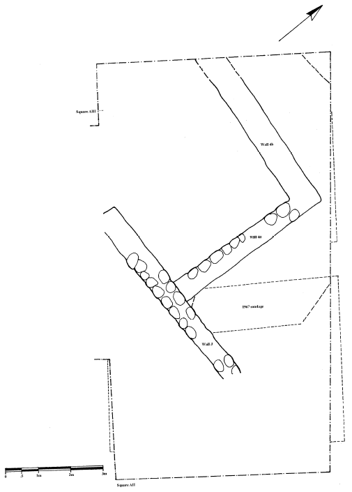 Fig. 3.10
Composite plan of Area A, phase B
Lovell (2001) - Fig. 3.11
Composite plan of Area A phase A from Lovell (2001)
 Fig. 3.11
Composite plan of Area A, phase A
Lovell (2001)
- Fig. 3.1a
Plan of Teleilat Ghassul showing excavated areas from Lovell (2001)
Fig. 3.1a
Plan of Teleilat Ghassul showing excavated areas
Lovell (2001) - Fig. 3.1b
Plan of Area A showing the position of Bourke's soundings from Lovell (2001)
Fig. 3.1b
Plan of Teleilat Ghassul, Area A showing the position of Bourke's soundings
Lovell (2001) - Fig. 3.9
Composite plan of Area A phase C from Lovell (2001)
Fig. 3.9
Composite plan of Area A, phase C
Lovell (2001) - Fig. 3.10
Composite plan of Area A phase B from Lovell (2001)
Fig. 3.10
Composite plan of Area A, phase B
Lovell (2001) - Fig. 3.11
Composite plan of Area A phase A from Lovell (2001)
Fig. 3.11
Composite plan of Area A, phase A
Lovell (2001)
- Fig. 1.2
Plan of excavated house from Tell 1 from Lovell (2001)
 Fig. 1.2
Plan of excavated house from Tell 1
(after Mallon et. al. 1934: fig. 12)
Lovell (2001) -
Plan of stratum IV on mound I from Stern et al (1993 v. 2)
 Tuleilat el-Ghassul: plan of stratum IV on mound I
Stern et al (1993 v. 2)
- Fig. 1.2
Plan of excavated house from Tell 1 from Lovell (2001)
Fig. 1.2
Plan of excavated house from Tell 1
(after Mallon et. al. 1934: fig. 12)
Lovell (2001) -
Plan of stratum IV on mound I from Stern et al (1993 v. 2)
Tuleilat el-Ghassul: plan of stratum IV on mound I
Stern et al (1993 v. 2)
- Fig. 3.14
section AII from Lovell (2001)
 Fig. 3.14
Teleilat Ghassul 1967-77, section AII
Lovell (2001)
- Fig. 3.13
AX Harris matrix from Lovell (2001)
 Fig. 3.13
AX Harris matrix
Lovell (2001) - Fig. 3.15
AII Harris matrix from Lovell (2001)
 Fig. 3.15
AII Harris matrix
Lovell (2001)
- Plate III.1
from Lovell (2001)
 Plate III.1
Teleilat Ghassul, aerial view taken in 1967
(Photo courtesy TG project)
Lovell (2001) - Plate III.2
from Lovell (2001)
 Plate III.2
AXI sondage (at original 1x2m) directly west of original Alli square. Note that the original baulks were cut back significantly in 1994 for safety
(Photo JLL)
Lovell (2001) - Plate III.9
from Lovell (2001)
 Plate III.9
AII, phase H/1, post holes and fill
(Photo TG Project)
Lovell (2001) - Plate III.14
from Lovell (2001)
 Plate III.14
AII, phase D, walls A', B', C', G'
(Photo TG Project)
Lovell (2001) - Plate III.15
from Lovell (2001)
 Plate III.15
AII, phase D, looking west. Note also the mudbrick bench associated with wall A'
(Photo TG Project)
Lovell (2001) - Plate III.16
from Lovell (2001)
 Plate III.16
AII, phase C walls J & K looking east.
(Photo TG Project)
Lovell (2001) - Plate III.17
from Lovell (2001)
 Plate III.17
AII, phase C, walls J, K, L & M at end 1967, note area of sondage to north
(Photo TG Project)
Lovell (2001) - Plate III.18
from Lovell (2001)
 Plate III.18
AII, phase A, wall 1 and Circular installation (Feature 8) looking west
(Photo TG Project)
Lovell (2001) - Plate III.19
from Lovell (2001)
 Plate III.19
AII, phase A, walls F, G and H looking northwest, note cut for Burial 3 to the left of walls F and G
(Photo TG Project)
Lovell (2001) - Plate III.20
from Lovell (2001)
 Plate III.20
AII, phase A, burial 4 looking north east
(Photo TG Project)
Lovell (2001) - Plate III.30
Fallen mudbricks AIII, phase E from Lovell (2001)
 Plate III.30
AIII, phase E, group of cornets and chisels amongst fallen mudbrick
(Photo courtesy TG project)
Lovell (2001)
- Fig. 1.2
Plan of excavated house from Tell 1 from Lovell (2001)
Fig. 1.2
Plan of excavated house from Tell 1
(after Mallon et. al. 1934: fig. 12)
Lovell (2001) - Fig. 3.1a
Plan of Teleilat Ghassul showing excavated areas from Lovell (2001)
Fig. 3.1a
Plan of Teleilat Ghassul showing excavated areas
Lovell (2001) - Fig. 3.1b
Plan of Area A showing the position of Bourke's soundings from Lovell (2001)
Fig. 3.1b
Plan of Teleilat Ghassul, Area A showing the position of Bourke's soundings
Lovell (2001)
- Plate III.1
from Lovell (2001)
Plate III.1
Teleilat Ghassul, aerial view taken in 1967
(Photo courtesy TG project)
Lovell (2001) - Plate III.2
from Lovell (2001)
Plate III.2
AXI sondage (at original 1x2m) directly west of original Alli square. Note that the original baulks were cut back significantly in 1994 for safety
(Photo JLL)
Lovell (2001)
- from Lovell (2001:19-20)
On the basis of his excavations Hennessy stated that he had isolated ten phases of occupation, A+ to I (Hennessy 1969). These effectively break down into four main phases of occupation, which I have termed Late Neolithic, Early Chalcolithic, Middle Chalcolithic and Late Chalcolithic (table 3.1). It must be stressed that it is not clear how these might relate to the original PBI determination of I-IV, which was based on crudely excavated information. It is shown in table 3.1 that Bourke's sondages include an extra phase (phase J) which predates the BSAJ/USyd's earliest phase (I). The BSAJ/USyd "pit-dwellings" were dug into sterile soil whereas Bourke's were dug into occupation levels that were largely without features (phase J). It is difficult to be definitive about the reason for this given the small exposures thus far revealed by the USyd team. Sterile was reached in the AX and AXI sondages at a lower absolute level than that of Hennessy's. It may be assumed that Bourke's sondages are, in fact, on the western-most edge of the Late Neolithic tell, and perhaps a little downslope from Hennessy's. In this case, phase J may not be significantly different from Hennessy's phases H and I, and for the purposes of this research, they are treated together.
Table 3.1 gives the stratigraphic phases as isolated in Hennessy's and Bourke's excavations. It should be noted that phases A+ to I, as they are interpreted here, may not correspond exactly to Hennessy's original divisions.
 Table 3.1
Correlation between BSAJ/USyd and USyd work
Lowell (2001)
Hennessy's first stratigraphic analysis was based solely upon the 1967 All sondage (Hennessy 1969). Detailed description of his stratigraphic divisions of deposits excavated after 1967 has never appeared in print. The stratigraphic analysis which appears here is my own interpretation of the two squares as a whole, and as they compare to Bourke's sondages. Correspondence between the two excavations was made largely on the basis of the sections and plans, taking into account similar features and absolute levels. The close proximity of Bourke's sondages to Hennessy's material made this relatively easy. The periodisation here is based upon major phase groupings. These rely upon the major changes in building phases (see below).
- from Lovell (2001)
 Table 6.1
A Proposed Relative and Absolute Chronology for the Teleilat Ghassul Sequence
Lovell (2001)
Through the various years of excavation, an area of over 10,500 sq m was exposed. Although the earlier excavators defined four main phases, the precision of Hennessy's more recent excavations defined ten major building phases separated by camp-floor occupations. The latter occurrences are interpreted as occupational subphases when the site was reconstructed for resettlement following periods of destruction. The entire sequence, labeled phases A through I, contains over one hundred successive floor levels. Although there is a paucity of reports concerning the recent excavations, the preliminary studies show technological development for the pottery and, to a limited extent, for the flint industries. The recent excavations also suggest that frequent seismic activity in the Jordan Valley caused the destruction of numerous settlements found in the archaeological sequence. Hennessy's excavations show no continuity for the Chalcolithic settlement into the subsequent Early Bronze Age, but there is a degree of continuity from the Late (Pottery) Neolithic period not noted by the original excavators. The following table equates the original four major phases (I-IV) with Hennessy's:
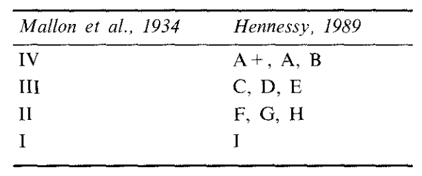 Table equating the original four major phases (I-IV) with Hennessy's
Stern et al (1993 v. 2)
- Fig. 3.1a
Plan of Teleilat Ghassul showing excavated areas from Lovell (2001)
Fig. 3.1a
Plan of Teleilat Ghassul showing excavated areas
Lovell (2001) - Fig. 3.1b
Plan of Area A showing the position of Bourke's soundings from Lovell (2001)
Fig. 3.1b
Plan of Teleilat Ghassul, Area A showing the position of Bourke's soundings
Lovell (2001) - Fig. 3.9
Composite plan of Area A phase C from Lovell (2001)
Fig. 3.9
Composite plan of Area A, phase C
Lovell (2001)
- Fig. 3.14
section AII from Lovell (2001)
Fig. 3.14
Teleilat Ghassul 1967-77, section AII
Lovell (2001)
- Fig. 3.15
AII Harris matrix from Lovell (2001)
Fig. 3.15
AII Harris matrix
Lovell (2001)
- Plate III.16
from Lovell (2001)
Plate III.16
AII, phase C walls J & K looking east.
(Photo TG Project)
Lovell (2001) - Plate III.17
from Lovell (2001)
Plate III.17
AII, phase C, walls J, K, L & M at end 1967, note area of sondage to north
(Photo TG Project)
Lovell (2001)
- Fig. 3.1a
Plan of Teleilat Ghassul showing excavated areas from Lovell (2001)
Fig. 3.1a
Plan of Teleilat Ghassul showing excavated areas
Lovell (2001) - Fig. 3.1b
Plan of Area A showing the position of Bourke's soundings from Lovell (2001)
Fig. 3.1b
Plan of Teleilat Ghassul, Area A showing the position of Bourke's soundings
Lovell (2001) - Fig. 3.10
Composite plan of Area A phase B from Lovell (2001)
Fig. 3.10
Composite plan of Area A, phase B
Lovell (2001)
- Fig. 3.14
section AII from Lovell (2001)
Fig. 3.14
Teleilat Ghassul 1967-77, section AII
Lovell (2001)
- Fig. 3.13
AX Harris matrix from Lovell (2001)
Fig. 3.13
AX Harris matrix
Lovell (2001)
- Fig. 3.1a
Plan of Teleilat Ghassul showing excavated areas from Lovell (2001)
Fig. 3.1a
Plan of Teleilat Ghassul showing excavated areas
Lovell (2001) - Fig. 3.1b
Plan of Area A showing the position of Bourke's soundings from Lovell (2001)
Fig. 3.1b
Plan of Teleilat Ghassul, Area A showing the position of Bourke's soundings
Lovell (2001) - Fig. 3.11
Composite plan of Area A phase A from Lovell (2001)
Fig. 3.11
Composite plan of Area A, phase A
Lovell (2001)
- Fig. 3.14
section AII from Lovell (2001)
Fig. 3.14
Teleilat Ghassul 1967-77, section AII
Lovell (2001)
- Fig. 3.15
AII Harris matrix from Lovell (2001)
Fig. 3.15
AII Harris matrix
Lovell (2001)
- Plate III.18
from Lovell (2001)
Plate III.18
AII, phase A, wall 1 and Circular installation (Feature 8) looking west
(Photo TG Project)
Lovell (2001) - Plate III.19
from Lovell (2001)
Plate III.19
AII, phase A, walls F, G and H looking northwest, note cut for Burial 3 to the left of walls F and G
(Photo TG Project)
Lovell (2001) - Plate III.20
from Lovell (2001)
Plate III.20
AII, phase A, burial 4 looking north east
(Photo TG Project)
Lovell (2001)
| Damage Type | Location | Image(s) | Comments |
|---|---|---|---|
| Fractures folds and popups on irregular pavements ? |
entrance to a structure outside the corner of walls J and K
Fig. 3.9 Composite plan of Area A, phase C Lovell (2001) |
Plate III.16 AII, phase C walls J & K looking east. (Photo TG Project) Lovell (2001)
Plate III.17AII, phase C, walls J, K, L & M at end 1967, note area of sondage to north (Photo TG Project) Lovell (2001) |
|
| Damage Type | Location | Image(s) | Comments |
|---|---|---|---|
| Displaced Wall ? | inside of wall 4b
Fig. 3.10 Composite plan of Area A, phase B Lovell (2001) |
|
| Damage Type | Location | Image(s) | Comments |
|---|---|---|---|
| Fractures folds and popups on irregular pavements ? |
area under walls G and F
Fig. 3.11 Composite plan of Area A, phase A Lovell (2001) |
|
- Earthquake Archeological Effects chart
of Rodríguez-Pascua et al (2013: 221-224)
 Earthquake Archeological Effects (EAE)
Rodríguez-Pascua et al (2013: 221-224)
| Damage Type | Location | Image(s) | Comments | Intensity |
|---|---|---|---|---|
| Fractures folds and popups on irregular pavements ? |
entrance to a structure outside the corner of walls J and K
Fig. 3.9 Composite plan of Area A, phase C Lovell (2001) |
Plate III.16 AII, phase C walls J & K looking east. (Photo TG Project) Lovell (2001)
Plate III.17AII, phase C, walls J, K, L & M at end 1967, note area of sondage to north (Photo TG Project) Lovell (2001) |
|
VI+ |
- Earthquake Archeological Effects chart
of Rodríguez-Pascua et al (2013: 221-224)
Earthquake Archeological Effects (EAE)
Rodríguez-Pascua et al (2013: 221-224)
| Damage Type | Location | Image(s) | Comments | Intensity |
|---|---|---|---|---|
| Displaced Wall ? | inside of wall 4b
Fig. 3.10 Composite plan of Area A, phase B Lovell (2001) |
|
VII+ ? |
- Earthquake Archeological Effects chart
of Rodríguez-Pascua et al (2013: 221-224)
Earthquake Archeological Effects (EAE)
Rodríguez-Pascua et al (2013: 221-224)
| Damage Type | Location | Image(s) | Comments | Intensity |
|---|---|---|---|---|
| Fractures folds and popups on irregular pavements ? |
area under walls G and F
Fig. 3.11 Composite plan of Area A, phase A Lovell (2001) |
|
VI+ ? |