Sha'ar Ramon
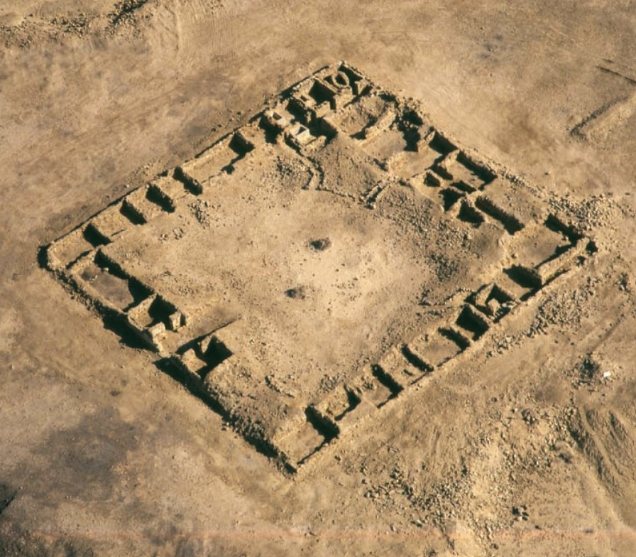 Fig 8
Fig 8Aerial view of the Nabataean caravanserai of Sha'ar Ramon located on the eastern edge of the Ramon Crater. (Courtesy of the Israel Antiquities Authority.)
Erickson-Gini and Israel (2013)
| Transliterated Name | Source | Name |
|---|---|---|
| Shdar Ramon | ||
| Sha'ar Ramon | ||
| Mesad Sha'ar Ramon | ||
| Qasr el-Mahalle | ||
| Moahila | ||
| 'En Saharonim |
- Fig. 1 - Major Roman trade routes
in the vicinity of Moje Awad from Bar-Oz et al (2022)
 Figure 1
Major Roman trade routes in the Negev and photographs of excavated sites. The red circles indicate the location of excavated dumps (photographs by R. Galili).
Bar-Oz et al (2022) - Fig. 1 - Map of the main
Hellenistic, Roman, and Byzantine sites in the Negev Hills from Stern et. al. (1993 v.3)
 Map of the main Hellenistic, Roman, and Byzantine sites in the Negev Hills.
Stern et. al. (1993 v.3)
- Fig. 1 - Major Roman trade routes
in the vicinity of Moje Awad from Bar-Oz et al (2022)
Figure 1
Major Roman trade routes in the Negev and photographs of excavated sites. The red circles indicate the location of excavated dumps (photographs by R. Galili).
Bar-Oz et al (2022) - Fig. 1 - Map of the main
Hellenistic, Roman, and Byzantine sites in the Negev Hills from Stern et. al. (1993 v.3)
Map of the main Hellenistic, Roman, and Byzantine sites in the Negev Hills.
Stern et. al. (1993 v.3)
- Sha'ar Ramon in Google Earth
 Sha'ar Ramon
click on image to explore this site on a new tab in Google Earth - Sha'ar Ramon on govmap.gov.il
 Sha'ar Ramon on govmap.gov.il
click on image to explore this site on a new tab in govmap.gov.il
- Sha'ar Ramon in Google Earth
Sha'ar Ramon
click on image to explore this site on a new tab in Google Earth - Sha'ar Ramon on govmap.gov.il
Sha'ar Ramon on govmap.gov.il
click on image to explore this site on a new tab in govmap.gov.il
- Fig. 8 - Aerial view of
Sha’ar-Ramon from Bar-Oz et al (2022)
 Figure 8
Aerial view of the Nabataean–Roman (first to second century AD) site of Sha’ar-Ramon and location of excavations (photograph by R. Galili).
Bar-Oz et al (2022) - Fig. 17 - Plan of the
Nabataean caravanserai of Sha'ar Ramon from Erickson-Gini and Israel (2013)
 Figure 17
Plan of the Nabataean caravanserai of Sha'ar Ramon. (Courtesy of the Israel Antiquities Authority.)
Erickson-Gini and Israel (2013)
- Fig. 8 - Aerial view of
Sha’ar-Ramon from Bar-Oz et al (2022)
Figure 8
Aerial view of the Nabataean–Roman (first to second century AD) site of Sha’ar-Ramon and location of excavations (photograph by R. Galili).
Bar-Oz et al (2022) - Fig. 17 - Plan of the
Nabataean caravanserai of Sha'ar Ramon from Erickson-Gini and Israel (2013)
Figure 17
Plan of the Nabataean caravanserai of Sha'ar Ramon. (Courtesy of the Israel Antiquities Authority.)
Erickson-Gini and Israel (2013)
| Effect | Location | Image(s) | Description |
|---|---|---|---|
|
Sha'ar Ramon
Figure 8 Aerial view of the Nabataean–Roman (first to second century AD) site of Sha’ar-Ramon and location of excavations (photograph by R. Galili). Bar-Oz et al (2022)
Figure 17Plan of the Nabataean caravanserai of Sha'ar Ramon. (Courtesy of the Israel Antiquities Authority.) Erickson-Gini and Israel (2013) |
|
- Earthquake Archeological Effects chart
of Rodríguez-Pascua et al (2013: 221-224)
 Earthquake Archeological Effects (EAE)
Rodríguez-Pascua et al (2013: 221-224)
| Effect | Location | Image(s) | Description | Intensity |
|---|---|---|---|---|
|
Sha'ar Ramon
Figure 8 Aerial view of the Nabataean–Roman (first to second century AD) site of Sha’ar-Ramon and location of excavations (photograph by R. Galili). Bar-Oz et al (2022)
Figure 17Plan of the Nabataean caravanserai of Sha'ar Ramon. (Courtesy of the Israel Antiquities Authority.) Erickson-Gini and Israel (2013) |
|
|