Paphos

 Left - Satellite Photo of New Paphos aka Nea Paphos or Kato Paphos (Κάτω Πάφος)
Right - Old Paphos aka Kouklia
Both Images from Google Earth
- Old Paphos in Google Earth
Old Paphos in Google Earth
click on image to explore this site on a new tab in Google Earth
- Plan of the Sanctuary
of Aphrodite in Old Paphos from wikipedia
 Sanctuary of Aphrodite, Palaepaphos
click on image to open a high res magnifiable version in a new tab
Rjdeadly - wikipedia - CC BY-SA 4.0

- Plan of the Sanctuary
of Aphrodite in Old Paphos from wikipedia
Sanctuary of Aphrodite, Palaepaphos
click on image to open a high res magnifiable version in a new tab
Rjdeadly - wikipedia - CC BY-SA 4.0
- New Paphos in Google Earth
 New Paphos in Google Earth
click on image to explore this site on a new tab in Google Earth
- Plan of Nea Paphos
from wikipedia
 Plan of Nea Paphos
Vitaliia Pavlyshyn - wikipedia - CC BY-SA 4.0 - Fig. 1 Plan of Nea
Paphos from Balandier and Guintrand (2023)
 Fig. 1
Site plan of Nea Paphos with indication of the main districts and monuments
Base map after K. Nicolaou and E. Papuci, modified by Cl. Balandier. Produced by E. Rossignol.
Balandier and Guintrand (2023) - Fig. 5 Plan of Nea
Paphos from Balandier and Guintrand (2023)
 Fig. 5
Site plan of Nea Paphos with indication of excavation operations by sector
Background map after Kyriakos Nicolaou and Ewdoksia Papuci-Wÿadyka, modified by Claire Balandier. Created by Emilie Rossignol.
Balandier and Guintrand (2023)
- Plan of Nea Paphos
from wikipedia
Plan of Nea Paphos
Vitaliia Pavlyshyn - wikipedia - CC BY-SA 4.0 - Fig. 1 Plan of Nea
Paphos from Balandier and Guintrand (2023)
Fig. 1
Site plan of Nea Paphos with indication of the main districts and monuments
Base map after K. Nicolaou and E. Papuci, modified by Cl. Balandier. Produced by E. Rossignol.
Balandier and Guintrand (2023) - Fig. 5 Plan of Nea
Paphos from Balandier and Guintrand (2023)
Fig. 5
Site plan of Nea Paphos with indication of excavation operations by sector
Background map after Kyriakos Nicolaou and Ewdoksia Papuci-Wÿadyka, modified by Claire Balandier. Created by Emilie Rossignol.
Balandier and Guintrand (2023)
- Fig. 1 Southern Rampart
to the west of the kastro (Ottoman castle) from Balandier and Guintrand (2023)
 Fig. 1
Surveys of the southern rampart to the west of the kastro (Ottoman castle). View towards the East.
Photos: Mafap/C. Balandier
Balandier and Guintrand (2023) - Fig. 2 Western Rampart
from Balandier and Guintrand (2023)
 Fig. 2
Surveys on the western rampart: rock tower. View towards the north.
Photos: Mafap/C. Balandier
Balandier and Guintrand (2023) - Fig. 3 Northern Rampart
to the northwest of Fabrika hill from Balandier and Guintrand (2023)
 Fig. 3
Survey of the base of the northern rampart to the northwest of Fabrika hill.
Photos: Mafap/C. Balandier
Balandier and Guintrand (2023) - Fig. 4 Western Rampart
from Balandier and Guintrand (2023)
 Fig. 4
Survey of the western edge of the ditch of western rampart (constrescarp) and the base of a proteichisma (?)
Photos: Mafap/C. Balandier
Balandier and Guintrand (2023)
- Fig. 1 Southern Rampart
to the west of the kastro (Ottoman castle) from Balandier and Guintrand (2023)
Fig. 1
Surveys of the southern rampart to the west of the kastro (Ottoman castle). View towards the East.
Photos: Mafap/C. Balandier
Balandier and Guintrand (2023) - Fig. 2 Western Rampart
from Balandier and Guintrand (2023)
Fig. 2
Surveys on the western rampart: rock tower. View towards the north.
Photos: Mafap/C. Balandier
Balandier and Guintrand (2023) - Fig. 3 Northern Rampart
to the northwest of Fabrika hill from Balandier and Guintrand (2023)
Fig. 3
Survey of the base of the northern rampart to the northwest of Fabrika hill.
Photos: Mafap/C. Balandier
Balandier and Guintrand (2023) - Fig. 4 Western Rampart
from Balandier and Guintrand (2023)
Fig. 4
Survey of the western edge of the ditch of western rampart (constrescarp) and the base of a proteichisma (?)
Photos: Mafap/C. Balandier
Balandier and Guintrand (2023)
- Fig. 100 Orthophoto of
Rescue operation and sounding #10 at the foot of the church of Panaghia Theoskepasti from Balandier and Guintrand (2023)
 Fig. 100
Orthophoto of Rescue operation and sounding #10 at the foot of the church of Panaghia Theoskepasti
Photogrammetric survey carried out in the field by Manuel Tastayre and Yohan Échaubard and computer processing carried out by Matthieu Guintrand
Balandier and Guintrand (2023) - Fig. 97 Block (?) and
cut rock to the north of the street from Balandier and Guintrand (2023)
 Fig. 97
Block (?) and cut rock to the north of the street. View towards the southwest.
Photo: C. Balandier.
Balandier and Guintrand (2023) - Fig. 98 Rocky base of
the church of Panaghia Theoskepasti from Balandier and Guintrand (2023)
 Fig. 98
Rocky base of the church of Panaghia Theoskepasti. View to the East.
Topographic survey by MafaP/Efa. Photos: MafaP/C. Balandier.
Balandier and Guintrand (2023) - Fig. 99 The rock cut
to the north of the church from Balandier and Guintrand (2023)
 Fig. 99
The rock cut to the north of the church. View to the South.
Topographic survey by MafaP/Efa. Photos: MafaP/C. Balandier.
Balandier and Guintrand (2023)
- Fig. 100 Orthophoto of
Rescue operation and sounding #10 at the foot of the church of Panaghia Theoskepasti from Balandier and Guintrand (2023)
Fig. 100
Orthophoto of Rescue operation and sounding #10 at the foot of the church of Panaghia Theoskepasti
Photogrammetric survey carried out in the field by Manuel Tastayre and Yohan Échaubard and computer processing carried out by Matthieu Guintrand
Balandier and Guintrand (2023) - Fig. 97 Block (?) and
cut rock to the north of the street from Balandier and Guintrand (2023)
Fig. 97
Block (?) and cut rock to the north of the street. View towards the southwest.
Photo: C. Balandier.
Balandier and Guintrand (2023) - Fig. 98 Rocky base of
the church of Panaghia Theoskepasti from Balandier and Guintrand (2023)
Fig. 98
Rocky base of the church of Panaghia Theoskepasti. View to the East.
Topographic survey by MafaP/Efa. Photos: MafaP/C. Balandier.
Balandier and Guintrand (2023) - Fig. 99 The rock cut
to the north of the church from Balandier and Guintrand (2023)
Fig. 99
The rock cut to the north of the church. View to the South.
Topographic survey by MafaP/Efa. Photos: MafaP/C. Balandier.
Balandier and Guintrand (2023)
- Fig. 115 Aerial View of
Cistern from Balandier and Guintrand (2023)
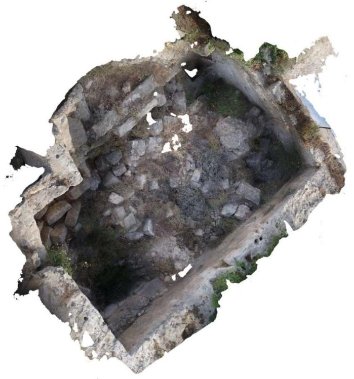 Fig. 115
The cistern. Zenith view.
Orthophoto: C. Abellan
Balandier and Guintrand (2023) - Fig. 116 Aerial View of
the southeast of the Fabrika hill plateau from Balandier and Guintrand (2023)
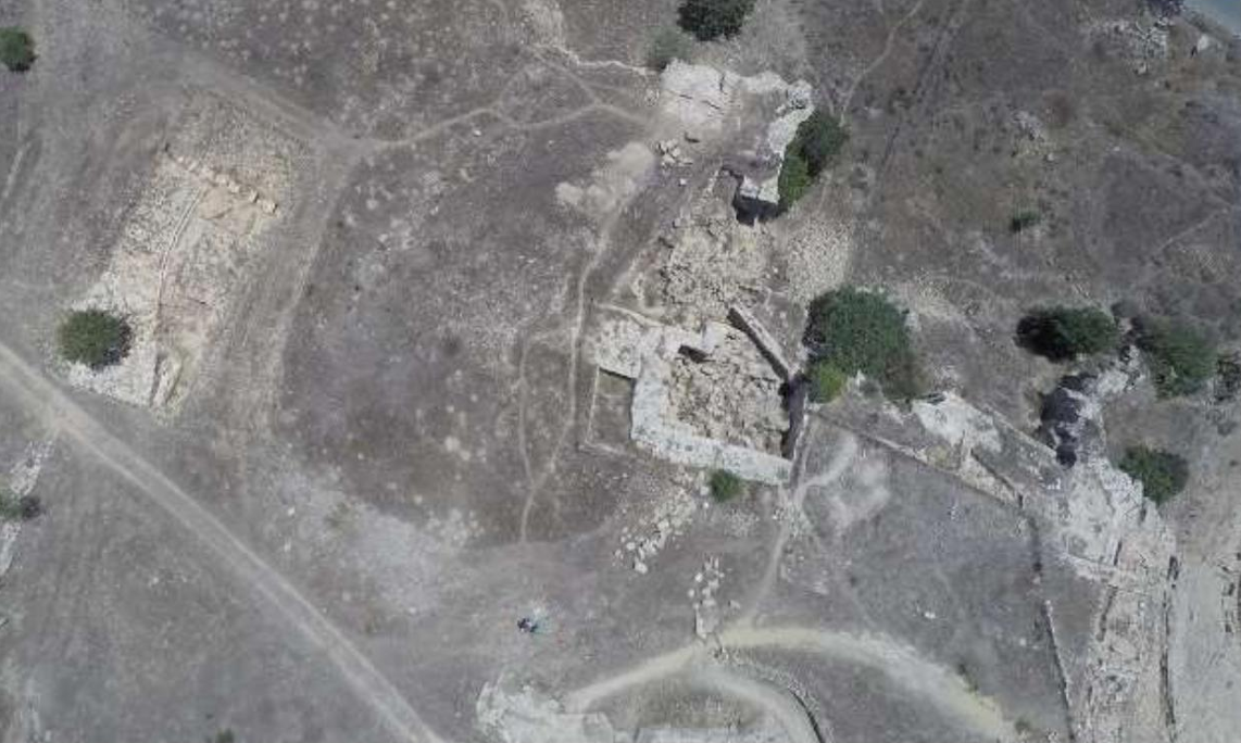 Fig. 116
Zenithal view of the southeast of the Fabrika hill plateau: aqueduct slabs on the left, cistern in the center and top of the theater on the right. North is on the left.
Photo: Mafap/Chr. Papadopoulos
Balandier and Guintrand (2023) - Fig. 117 View of the
cistern during excavation from Balandier and Guintrand (2023)
 Fig. 117
View of the cistern during excavation with the outlet of the underground gallery through the north wall. View towards the North.
Photo: Mafap/C. Balandier 2011.
Balandier and Guintrand (2023)
- Fig. 115 Aerial View of
Cistern from Balandier and Guintrand (2023)
Fig. 115
The cistern. Zenith view.
Orthophoto: C. Abellan
Balandier and Guintrand (2023) - Fig. 116 Aerial View of
the southeast of the Fabrika hill plateau from Balandier and Guintrand (2023)
Fig. 116
Zenithal view of the southeast of the Fabrika hill plateau: aqueduct slabs on the left, cistern in the center and top of the theater on the right. North is on the left.
Photo: Mafap/Chr. Papadopoulos
Balandier and Guintrand (2023) - Fig. 117 View of the
cistern during excavation from Balandier and Guintrand (2023)
Fig. 117
View of the cistern during excavation with the outlet of the underground gallery through the north wall. View towards the North.
Photo: Mafap/C. Balandier 2011.
Balandier and Guintrand (2023)
| Effect | Location | Image(s) | Description |
|---|---|---|---|
|
Paphos Fortification Walls and Ramparts, particulalrly beneath and adjacent/near to the church of Panaghia Theoskepasti
Fig. 5 Site plan of Nea Paphos with indication of excavation operations by sector Background map after Kyriakos Nicolaou and Ewdoksia Papuci-Wÿadyka, modified by Claire Balandier. Created by Emilie Rossignol. Balandier and Guintrand (2023)
Fig. 100Orthophoto of Rescue operation and sounding #10 at the foot of the church of Panaghia Theoskepasti Photogrammetric survey carried out in the field by Manuel Tastayre and Yohan Échaubard and computer processing carried out by Matthieu Guintrand Balandier and Guintrand (2023) |
Fig. 97 Block (?) and cut rock to the north of the street. View towards the southwest. Photo: C. Balandier. Balandier and Guintrand (2023)
Fig. 98Rocky base of the church of Panaghia Theoskepasti. View to the East. Topographic survey by MafaP/Efa. Photos: MafaP/C. Balandier. Balandier and Guintrand (2023)
Fig. 99The rock cut to the north of the church. View to the South. Topographic survey by MafaP/Efa. Photos: MafaP/C. Balandier. Balandier and Guintrand (2023) |
|
| Effect | Location | Image(s) | Description |
|---|---|---|---|
|
Fabrika Hill in Paphos
Fig. 1 Site plan of Nea Paphos with indication of the main districts and monuments Base map after K. Nicolaou and E. Papuci, modified by Cl. Balandier. Produced by E. Rossignol. Balandier and Guintrand (2023)
Fig. 116Zenithal view of the southeast of the Fabrika hill plateau: aqueduct slabs on the left, cistern in the center and top of the theater on the right. North is on the left. Photo: Mafap/Chr. Papadopoulos Balandier and Guintrand (2023) |
Fig. 115 The cistern. Zenith view. Orthophoto: C. Abellan Balandier and Guintrand (2023)
Fig. 117View of the cistern during excavation with the outlet of the underground gallery through the north wall. View towards the North. Photo: Mafap/C. Balandier 2011. Balandier and Guintrand (2023) |
|
-
Earthquake Archeological Effects chart
of Rodríguez-Pascua et al (2013: 221-224)
 Earthquake Archeological Effects (EAE)
Rodríguez-Pascua et al (2013: 221-224)
| Effect | Location | Image(s) | Description | Intensity |
|---|---|---|---|---|
|
Paphos and Cyprus in general |
|
|
-
Earthquake Archeological Effects chart
of Rodríguez-Pascua et al (2013: 221-224)
Earthquake Archeological Effects (EAE)
Rodríguez-Pascua et al (2013: 221-224)
| Effect | Location | Image(s) | Description | Intensity |
|---|---|---|---|---|
|
Paphos, Cyprus |
|
|
- Earthquake Archeological
Effects from Rodríguez-Pascua et al (2013: 221-224)
 Earthquake Archeological
Effects Chart
Earthquake Archeological
Effects Chart
Click on image to open in a new tab
Rodríguez-Pascua et al (2013) - Synoptic Table of ESI 2007
Intensity Degrees from Michetti et al. (2007)
 Synoptic Table of ESI 2007
Intensity Degrees
Synoptic Table of ESI 2007
Intensity Degrees
Accuracy improves in higher degrees, especially VIII–XII.
Click on image to open in a new tab
Michetti et al. (2007)
| Effect | Location | Image(s) | Description | Intensity |
|---|---|---|---|---|
|
Paphos Fortification Walls and Ramparts, particulalrly beneath and adjacent/near to the church of Panaghia Theoskepasti
Fig. 5 Site plan of Nea Paphos with indication of excavation operations by sector Background map after Kyriakos Nicolaou and Ewdoksia Papuci-Wÿadyka, modified by Claire Balandier. Created by Emilie Rossignol. Balandier and Guintrand (2023)
Fig. 100Orthophoto of Rescue operation and sounding #10 at the foot of the church of Panaghia Theoskepasti Photogrammetric survey carried out in the field by Manuel Tastayre and Yohan Échaubard and computer processing carried out by Matthieu Guintrand Balandier and Guintrand (2023) |
Fig. 97 Block (?) and cut rock to the north of the street. View towards the southwest. Photo: C. Balandier. Balandier and Guintrand (2023)
Fig. 98Rocky base of the church of Panaghia Theoskepasti. View to the East. Topographic survey by MafaP/Efa. Photos: MafaP/C. Balandier. Balandier and Guintrand (2023)
Fig. 99The rock cut to the north of the church. View to the South. Topographic survey by MafaP/Efa. Photos: MafaP/C. Balandier. Balandier and Guintrand (2023) |
|
|
- Earthquake Archeological
Effects from Rodríguez-Pascua et al (2013: 221-224)
Earthquake Archeological
Effects Chart
Click on image to open in a new tab
Rodríguez-Pascua et al (2013) - Synoptic Table of ESI 2007
Intensity Degrees from Michetti et al. (2007)
Synoptic Table of ESI 2007
Intensity Degrees
Accuracy improves in higher degrees, especially VIII–XII.
Click on image to open in a new tab
Michetti et al. (2007)
| Effect | Location | Image(s) | Description | Intensity |
|---|---|---|---|---|
|
Fabrika Hill in Paphos
Fig. 1 Site plan of Nea Paphos with indication of the main districts and monuments Base map after K. Nicolaou and E. Papuci, modified by Cl. Balandier. Produced by E. Rossignol. Balandier and Guintrand (2023)
Fig. 116Zenithal view of the southeast of the Fabrika hill plateau: aqueduct slabs on the left, cistern in the center and top of the theater on the right. North is on the left. Photo: Mafap/Chr. Papadopoulos Balandier and Guintrand (2023) |
Fig. 115 The cistern. Zenith view. Orthophoto: C. Abellan Balandier and Guintrand (2023)
Fig. 117View of the cistern during excavation with the outlet of the underground gallery through the north wall. View towards the North. Photo: Mafap/C. Balandier 2011. Balandier and Guintrand (2023) |
|
|
- from Inscriptiones Graecae Ad Res Romanas Pertinentes (IGR) Vol. III: 356-357 (Inscription Numbers 939, 941-944 according to Ambraseys, 2009)
- from Hathi Trust


- from Dussaud (1895:299-300)
- Ambraseys (2009) cites this for a ~17-15 BCE earthquake in Cyprus (Paphos) but the inscription was found in Byblos, Lebanon and although it mentions that Apollodorus Nikonos was lucky to be saved from an earthquake, it does not specify the location of the earthquake. Based on context, one might think that the earthquake affected Byblos

