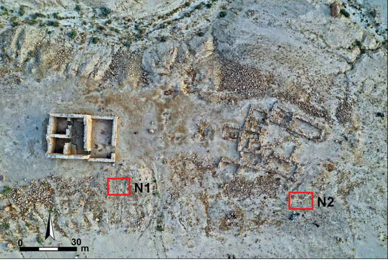
Open this page in a new tab

Neqarot Fort

Neqarot Fort Figure 6

Aerial view of the Nabataean–Roman (first to third century AD) site of Neqarot Fort and location of excavations (photograph by R. Galili).

Bar-Oz et al (2022)


Names

Transliterated Name Source Name
Mezad Neqarot Hebrew
Neqarot Fort English
Qasr Wadi es-Siq Arabic
Introduction
Introduction

Neqarot Fort was built on the banks of Nahal Neqarot adjacent to Nabataean dwellings that were constructed at the beginning of the first century CE ( Bar-Oz et al, 2022). The fort was abandoned in the 3rd century CE ( Bar-Oz et al, 2022). The site comprises a tower with a yard (8 × 7.5m); a ruined rectangular residential complex (17 × 12m); a water pool complex (7 × 7m); and a small (3 × 4m) watch tower on the hill ( Bar-Oz et al, 2022).

Description and Excavations

Mezad Neqarot, a site situated on a low hill near the north bank of Nahal Neqarot (map reference 1500.9985) was first surveyed in 1932 by F. Frank, who called it Qasr Wadi es-Siq and drew a plan of it; he dated the remains to the Roman period. Later the site was surveyed by N. Glueck, M. Gichon, B. Rothenberg, A. Negev, and others, who considered it a road station along the Nabatean Petra-Oboda-Gaza highway. The site was also surveyed by a team under D. Nahlieli and Y. Israel for the Negev Emergency Survey. In 1981-1982, R. Cohen directed salvage excavations here, of four structures, on behalf of the Israel Department of Antiquities and Museums. Two of the structures were on a low hill near the northern bank of Nahal Neqarot: the first(A) on the western part of the hill and the second (B) some 20 m to the east. On the summit of a hill east of the structures stood a small watchtower (structure C). The fourth structure (D) was a stone-built pool on the slope of the ridge south of the bank of Nahal Neqarot.

Maps, Aerial Views, and Plans

Maps

  • Fig. 1 - Major Roman trade routes in the vicinity of Neqarot Fort from Bar-Oz et al (2022)

Aerial Views

  • Fig. 6 - Aerial view of Neqarot Fort from Bar-Oz et al (2022)
  • Nahal Neqarot in the vicinity of Neqarot Fort in Google Earth
  • Nahal Neqarot in the vicinity of Neqarot Fort on govmap.gov.il

Plans

  • Plan of structure A from Stern et. al. (1993 v.3)
  • Plan of structure B from Stern et. al. (1993 v.3)

Chronology
Early 2nd century CE Earthquake

Erickson-Gini (2012) states

Although unreported in historical sources, a growing body of archaeological evidence points to widespread earthquake destruction in several Nabataean sites in southern Jordan and the Negev, including ... Nahal Neqarot (Erickson-Gini T. 2010. Nabataean Settlement and Self-Organized Economy in the Central Negev [Bar Int. Ser. 2054]. Oxford)
Erickson-Gini and Israel (2013) state
Evidence of an early second-century CE earthquake is out in the Severan period when the forts were built and found at other sites along the Incense Road at Nahal Neqarot, Shaʼar Ramon, and particularly at the head of the Mahmal Pass where an Early Roman Nabataean structure collapsed (Korjenkov and Erickson-Gini 2003; Erickson-Gini 2011). There is ample evidence of the immediate reconstruction of buildings at Moyat ‘Awad, Shaʼar Ramon, and Horvat Daft. However, this does not seem to be the case with the Mahmal and Neqarot sites.

... Where sites were repaired, such as Moyat ‘Awad and Shaʼar Ramon, the Roman army utilized them without introducing new structures. In other cases forts were built next to earlier collapsed buildings (Mahmal and Neqarot) or, as in the case of Qasra, a whole new site was developed.

... International trade along the road was robust through-out the second century CE, and its economic importance motivated the Romans to build new forts along its length in order to ensure its security. At two sites, the Neqarot and Mahmal, the new installations appear to have replaced Nabataean structures destroyed by an earthquake that took place shortly before annexation in the early second century CE.

Seismic Effects
Early 2nd century CE Earthquake

Effect(s) Location Image(s) Description
Collapsed Walls               Nabataean structures
  • Although unreported in historical sources, a growing body of archaeological evidence points to widespread earthquake destruction in several Nabataean sites in southern Jordan and the Negev, including ... Nahal Neqarot (Erickson-Gini T. 2010. Nabataean Settlement and Self-Organized Economy in the Central Negev [Bar Int. Ser. 2054]. Oxford) - Erickson-Gini (2012)

  • Where sites were repaired, such as Moyat ‘Awad and Shaʼar Ramon, the Roman army utilized them without introducing new structures. In other cases forts were built next to earlier collapsed buildings (Mahmal and Neqarot) - Erickson-Gini and Israel (2013)

  • At two sites, the Neqarot and Mahmal, the new installations appear to have replaced Nabataean structures destroyed by an earthquake that took place shortly before annexation in the early second century CE. - Erickson-Gini and Israel (2013)

Intensity Estimates
End of Early Roman Phase earthquake - early 2nd century CE

Effect(s) Location Image(s) Description Intensity
Collapsed Walls               Nabataean structures
  • Although unreported in historical sources, a growing body of archaeological evidence points to widespread earthquake destruction in several Nabataean sites in southern Jordan and the Negev, including ... Nahal Neqarot (Erickson-Gini T. 2010. Nabataean Settlement and Self-Organized Economy in the Central Negev [Bar Int. Ser. 2054]. Oxford) - Erickson-Gini (2012)

  • Where sites were repaired, such as Moyat ‘Awad and Shaʼar Ramon, the Roman army utilized them without introducing new structures. In other cases forts were built next to earlier collapsed buildings (Mahmal and Neqarot) - Erickson-Gini and Israel (2013)

  • At two sites, the Neqarot and Mahmal, the new installations appear to have replaced Nabataean structures destroyed by an earthquake that took place shortly before annexation in the early second century CE. - Erickson-Gini and Israel (2013)
VIII+
The archeoseismic evidence requires a minimum Intensity of VIII (8) when using the Earthquake Archeological Effects chart of Rodríguez-Pascua et al (2013: 221-224).

Notes and Further Reading
References