Moje Awad
 Fig 3
Fig 3Aerial view of the Hellenistic Nabataean fort (Area B) at Moyat ‘Awad located in the western Arabah. (Courtesy of the Israel Antiquities Authority.)
Erickson-Gini and Israel (2013)
| Transliterated Name | Source | Name |
|---|---|---|
| Moje Awad | ||
| Moyat ‘Awad | Arabic | |
| Orhan-Mor | Hebrew? | |
| Moa | incorrect identification |
- Fig. 1 - Major Roman trade
routes in the vicinity of Moje Awad from Bar-Oz et al (2022)
 Figure 1
Major Roman trade routes in the Negev and photographs of excavated sites. The red circles indicate the location of excavated dumps (photographs by R. Galili).
Bar-Oz et al (2022)
- Fig. 3 - Aerial view of Moje Awad
from Bar-Oz et al (2022)
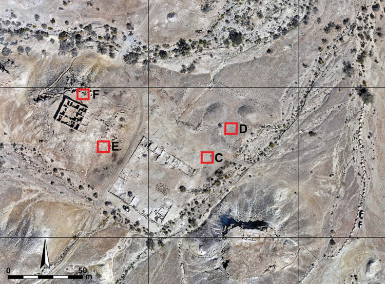 Figure 3
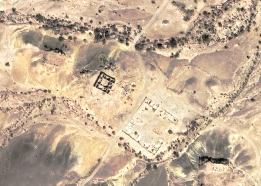
Aerial view of the Nabataean–Roman (first to third century AD) site of Orhan-Mor and the location of excavations (photograph by R. Galili).
Bar-Oz et al (2022) - Fig. 3 - Aerial view of the
Hellenistic Nabataean fort from Erickson-Gini and Israel (2013)
Fig 3
Aerial view of the Hellenistic Nabataean fort (Area B) at Moyat ‘Awad located in the western Arabah. (Courtesy of the Israel Antiquities Authority.)
Erickson-Gini and Israel (2013) - Moje Awad in Google Earth
 Moje Awad in Google Earth
click on image to explore this site on a new tab in Google Earth - Moje Awad on govmap.gov.il
 Moje Awad on govmap.gov.il
click on image to explore this site on a new tab in govmap.gov.il
- Fig. 24 - Plan of the site
from Erickson-Gini and Israel (2013)
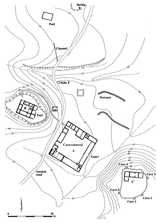 Figure 24
Plan of the site of Moyat ‘Awad in the western Arabah. (Courtesy of the Israel Antiquities Authority.)
Erickson-Gini and Israel (2013)
- Fig. 24 - Plan of the site
from Erickson-Gini and Israel (2013)
Figure 24
Plan of the site of Moyat ‘Awad in the western Arabah. (Courtesy of the Israel Antiquities Authority.)
Erickson-Gini and Israel (2013)
- Fig. 24 - Plan of the site from
Erickson-Gini and Israel (2013)
Figure 24
Plan of the site of Moyat ‘Awad in the western Arabah. (Courtesy of the Israel Antiquities Authority.)
Erickson-Gini and Israel (2013)
| Effect(s) | Location | Image(s) | Description |
|---|---|---|---|
| Collapsed Walls | The building in Area C and the kiln works
Figure 24 Plan of the site of Moyat ‘Awad in the western Arabah. (Courtesy of the Israel Antiquities Authority.) Erickson-Gini and Israel (2013) |
|
|
| Collapsed caves ? | cave dwellings
Figure 24 Plan of the site of Moyat ‘Awad in the western Arabah. (Courtesy of the Israel Antiquities Authority.) Erickson-Gini and Israel (2013) |
|
-
Earthquake Archeological Effects chart
of Rodríguez-Pascua et al (2013: 221-224)
 Earthquake Archeological Effects (EAE)
Rodríguez-Pascua et al (2013: 221-224)
| Effect(s) | Location | Image(s) | Description | Intensity |
|---|---|---|---|---|
| Collapsed Walls | The building in Area C and the kiln works
Figure 24 Plan of the site of Moyat ‘Awad in the western Arabah. (Courtesy of the Israel Antiquities Authority.) Erickson-Gini and Israel (2013) |
|
VIII+ | |
| Collapsed caves ? | cave dwellings
Figure 24 Plan of the site of Moyat ‘Awad in the western Arabah. (Courtesy of the Israel Antiquities Authority.) Erickson-Gini and Israel (2013) |
|
III+? |