Mezad Mahmal
 Mezad Mahmal on govmap.gov.il
click on image to explore this site on a new tab in govmap.gov.il
| Transliterated Name | Source | Name |
|---|---|---|
| Mezad Mahmal | Hebrew | |
| Mezad Ma'ale Mahmal | Hebrew | |
- Fig. 1 Location Map
from Erickson-Gini (2011)
 Figure 1
Location Map
Erickson-Gini (2011)
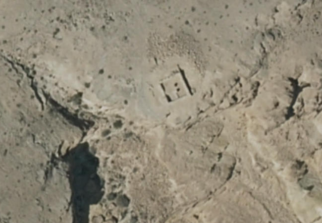
- Mezad Mahmal in Google Earth
 Mezad Mahmal in Google Earth
click on image to explore this site on a new tab in Google Earth - Mezad Mahmal on govmap.gov.il
Mezad Mahmal on govmap.gov.il
click on image to explore this site on a new tab in govmap.gov.il
- Fig. 3 Plan of Mezad Mahmal
from Erickson-Gini (2011)
 Figure 3
Plan
Erickson-Gini (2011)
- Mezad Mahmal (long shot)
from Rudolf Cohen in Stern et. al. (1993 v.3)
 Mezad Ma'ale Mahmal: general view
Stern et. al. (1993 v.3) - Mezad Mahmal (close up)
from Rudolf Cohen in Stern et. al. (1993 v.3)
 Mezad Ma'ale Mahmal.
Stern et. al. (1993 v.3) - Fig. 2 Mezad Mahmal (close up)
from Erickson-Gini (2011)
 Figure 2
Late Roman fort, looking northeast
Erickson-Gini (2011) - Fig. 6 Tabun F-1
from Erickson-Gini (2011)
 Figure 6
Tabun F-1, looking west
Erickson-Gini (2011) - Fig. 7 - Jar in collapse
from Erickson-Gini (2011)
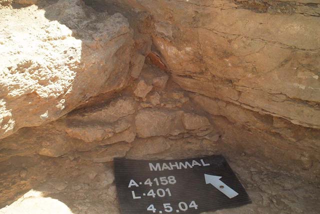 Figure 7
Jar in collapse in the corner of L402, looking northwest.
Erickson-Gini (2011) - Fig. 8 - Collapse of Wall 1
from Erickson-Gini (2011)
 Figure 8
Collapse of Wall 1 in the courtyard, looking west.
Erickson-Gini (2011)
- Plan of Mezad Mahmal
from Erickson-Gini (2011)
Figure 3
Plan
Erickson-Gini (2011) - Fig. 7 - Jar in collapse
from Erickson-Gini (2011)
Figure 7
Jar in collapse in the corner of L402, looking northwest.
Erickson-Gini (2011) - Fig. 8 - Collapse of Wall 1
from Erickson-Gini (2011)
Figure 8
Collapse of Wall 1 in the courtyard, looking west.
Erickson-Gini (2011)
| Effect(s) | Location | Image(s) | Description |
|---|---|---|---|
| Collapsed Walls |
Figure 3 Plan Erickson-Gini (2011) |
Figure 8 Collapse of Wall 1 in the courtyard, looking west. Erickson-Gini (2011) |
|
| Broken Pottery | L601
Figure 3 Plan Erickson-Gini (2011) |
Figure 6 Tabun F-1, looking west Erickson-Gini (2011) |
|
| Broken Pottery | L402
Figure 3 Plan Erickson-Gini (2011) |
Figure 7 Jar in collapse in the corner of L402, looking northwest. Erickson-Gini (2011) |
|
- Modified by JW from Fig. 3 of Erickson-Gini (2011)
 Deformation Map
click on image to open in a new tab
Modified by JW from Fig. 3 of Erickson-Gini (2011)
-
Earthquake Archeological Effects chart
of Rodríguez-Pascua et al (2013: 221-224)
 Earthquake Archeological Effects (EAE)
Rodríguez-Pascua et al (2013: 221-224)
| Effect(s) | Location | Image(s) | Description | Intensity |
|---|---|---|---|---|
| Collapsed Walls |
Figure 3 Plan Erickson-Gini (2011) |
Figure 8 Collapse of Wall 1 in the courtyard, looking west. Erickson-Gini (2011) |
|
VIII+ |
| Broken Pottery | L601
Figure 3 Plan Erickson-Gini (2011) |
Figure 6 Tabun F-1, looking west Erickson-Gini (2011) |
|
VII+ |
| Broken Pottery | L402
Figure 3 Plan Erickson-Gini (2011) |
Figure 7 Jar in collapse in the corner of L402, looking northwest. Erickson-Gini (2011) |
|
VII+ |