Magdala
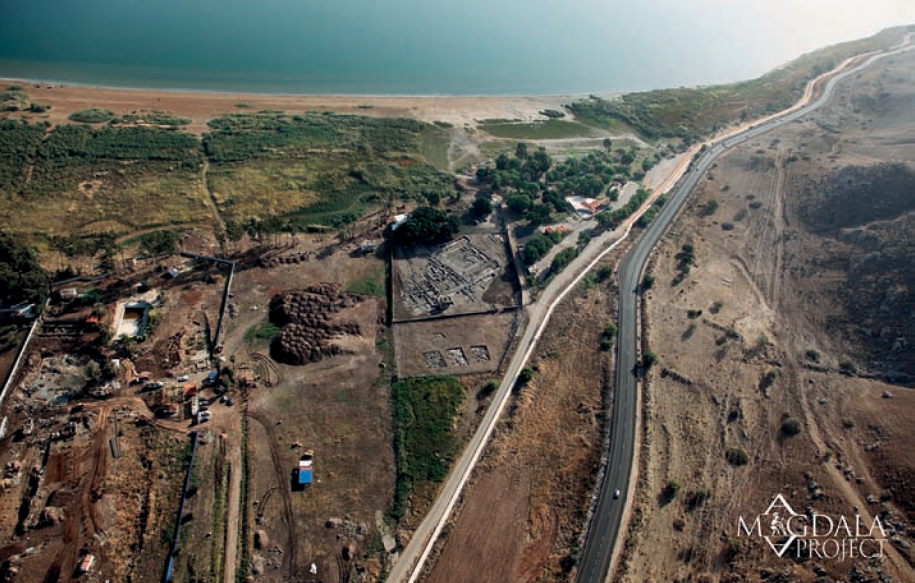 Fig. 7
Aerial view of Magdala–Taricheae from West. Courtesy of S. De Luca © Magdala Project (M. Eisenberg 2010)
De Luca and Lena (2014)
| Transliterated Name | Source | Name |
|---|---|---|
| Migdal | Hebrew | מגדל |
| al-Majdal | Arabic | المجدل |
| Magdala Nunayya | Aramaic in the Babylonian Talmud | מגדלא נוניה |
| Magdala Sebaya | Jewish sources | |
| Dalmanoutha | possibly in Mark 8:10 | |
| Magadan | possibly in Matthew 15:39 | |
| Taricheae | Greek | Ταριχαία or Ταριχέα |
| Magdala | Aramaic | מגדלא |
- Fig. 1 - Location Map
from de Luca and Lena (2014)
 Fig. 1
Schematic Map of the Sea of Galilee: Anchorages and Coastal Sites. Courtesy of S. De Luca © Magdala Project (S. De Luca – A. Ricci)
De Luca and Lena (2014) - Fig. 2 - Topographic Map
of the area from de Luca and Lena (2014)
 Fig. 2
Topographic Map of the Area of Magdala–Taricheae and surroundings. The letters show the digs. Courtesy of S. De Luca © Magdala Project 2011–2012 (S. De Luca – A. Ricci)
De Luca and Lena (2014)
- Fig. 1 - Location Map
from de Luca and Lena (2014)
Fig. 1
Schematic Map of the Sea of Galilee: Anchorages and Coastal Sites. Courtesy of S. De Luca © Magdala Project (S. De Luca – A. Ricci)
De Luca and Lena (2014) - Fig. 2 - Topographic Map
of the area from de Luca and Lena (2014)
Fig. 2
Topographic Map of the Area of Magdala–Taricheae and surroundings. The letters show the digs. Courtesy of S. De Luca © Magdala Project 2011–2012 (S. De Luca – A. Ricci)
De Luca and Lena (2014)
- Annotated Satellite View
of Magdala from biblewalks.com
- Magdala in Google Earth
 Magdala in Google Earth
click on image to explore this site on a new tab in Google Earth - Magdala on govmap.gov.il
 Magdala on govmap.gov.il
click on image to explore this site on a new tab in govmap.gov.il

- Fig. 3 - General Plan
of the Magdala Project from de Luca and Lena (2014)
 Fig. 3
General Plan of the Magdala Project 2007–2011 Excavations. Courtesy of S. De Luca © Magdala Project 2011–2012 (S. De Luca – A. Ricci)
De Luca and Lena (2014)
- Fig. 3 - General Plan
of the Magdala Project from de Luca and Lena (2014)
Fig. 3
General Plan of the Magdala Project 2007–2011 Excavations. Courtesy of S. De Luca © Magdala Project 2011–2012 (S. De Luca – A. Ricci)
De Luca and Lena (2014)
- Fig. 4 - Harbors plan
from de Luca and Lena (2014)
 Fig. 4
Plan of the Harbors Structures. Magdala Project 2007–2011 Excavations
Color Code
- green - Hasmonean and Herodian (2nd century BC-1st AD)
- yellow - early and middle Roman (1st - 3rd century AD)
- blue - late Roman and Byzantine (3rd-7th century AD)
- purple - Arab and medieval (7th-11th century AD)
- gray - encumbrances of the paved road axes
Courtesy of S. De Luca © Magdala Project 2011–2012 (S. De Luca – A. Ricci)
De Luca and Lena (2014) - Fig. 5 - Byzantine Harbor
plan from de Luca and Lena (2014)
 Fig. 5
Schematic Plan of the Byzantine Harbor of Magdala (Adapted from Raban 1988, fig. 7). Courtesy of S. De Luca © Magdala Project 2011–2012 (S. De Luca – A. Ricci)
De Luca and Lena (2014)
- Fig. 4 - Harbors plan
from de Luca and Lena (2014)
Fig. 4
Plan of the Harbors Structures. Magdala Project 2007–2011 Excavations
Color Code
- green - Hasmonean and Herodian (2nd century BC-1st AD)
- yellow - early and middle Roman (1st - 3rd century AD)
- blue - late Roman and Byzantine (3rd-7th century AD)
- purple - Arab and medieval (7th-11th century AD)
- gray - encumbrances of the paved road axes
Courtesy of S. De Luca © Magdala Project 2011–2012 (S. De Luca – A. Ricci)
De Luca and Lena (2014) - Fig. 5 - Byzantine Harbor
plan from de Luca and Lena (2014)
Fig. 5
Schematic Plan of the Byzantine Harbor of Magdala (Adapted from Raban 1988, fig. 7). Courtesy of S. De Luca © Magdala Project 2011–2012 (S. De Luca – A. Ricci)
De Luca and Lena (2014)
- Fig. 5 - Plan and sections
of Areas E and F from Lena (2013)
 Fig. 5
Areas E and F, eastern side, plans and views
Color Code
- green - Hasmonean and Herodian (2nd century BC-1st AD)
- yellow - early and middle Roman (1st - 3rd century AD)
- blue - late Roman and Byzantine (3rd-7th century AD)
- purple - Arab and medieval (7th-11th century AD)
- gray - encumbrances of the paved road axes
Lena (2013)
- Fig. 5 - Plan and sections
of Areas E and F from Lena (2013)
Fig. 5
Areas E and F, eastern side, plans and views
Color Code
- green - Hasmonean and Herodian (2nd century BC-1st AD)
- yellow - early and middle Roman (1st - 3rd century AD)
- blue - late Roman and Byzantine (3rd-7th century AD)
- purple - Arab and medieval (7th-11th century AD)
- gray - encumbrances of the paved road axes
Lena (2013)
- Plate 6 - Plan of Areas
H1, H2, and H3, at the end of the 2007 season from De Luca (2009)
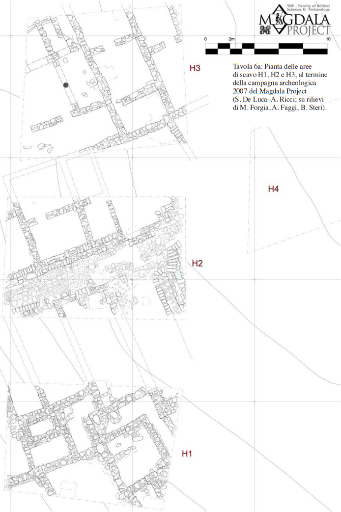 Plate 6
Plan of excavation areas H1, H2, and H3, at the end of the 2007 season of the Magdala Project
(S. De Luca—A. Ricci; relief from M. Forgia, A. Faggi, and B. Stern).
De Luca (2009 - Plate 7 - Collapses in
Area H1 from De Luca (2009)
 Plate 7
Magdala/Taricheae, Area H1. Survey of the wall structures and collapses with indication of the main US and USM
(S. De Luca—M. Forgia).
De Luca (2009 - Plate 8 - Collapses in
Area H2 from De Luca (2009)
 Plate 8
Magdala/Taricheae, Area H2. Survey of the wall structures and collapses with indication of the main US and USM
(S. De Luca—A. Faggi).
De Luca (2009 - Plate 9 - Collapses in
Area H3 from De Luca (2009)
 Plate 9
Magdala/Taricheae, Area H3. Survey of the wall structures and collapses with indication of the main US and USM
(S. De Luca—B. Stern).
De Luca (2009
- Plate 6 - Plan of Areas
H1, H2, and H3, at the end of the 2007 season from De Luca (2009)
Plate 6
Plan of excavation areas H1, H2, and H3, at the end of the 2007 season of the Magdala Project
(S. De Luca—A. Ricci; relief from M. Forgia, A. Faggi, and B. Stern).
De Luca (2009 - Plate 7 - Collapses in
Area H1 from De Luca (2009)
Plate 7
Magdala/Taricheae, Area H1. Survey of the wall structures and collapses with indication of the main US and USM
(S. De Luca—M. Forgia).
De Luca (2009 - Plate 8 - Collapses in
Area H2 from De Luca (2009)
Plate 8
Magdala/Taricheae, Area H2. Survey of the wall structures and collapses with indication of the main US and USM
(S. De Luca—A. Faggi).
De Luca (2009 - Plate 9 - Collapses in
Area H3 from De Luca (2009)
Plate 9
Magdala/Taricheae, Area H3. Survey of the wall structures and collapses with indication of the main US and USM
(S. De Luca—B. Stern).
De Luca (2009
- Fig. 10 - Sections from
de Luca and Lena (2014)
 Fig. 10
Elevation and Sections of the Hasmonean Mooring Place and of the Early Roman Inner Basin, with mooring stones (MS 1 and 4) in situ. Courtesy of S. De Luca © Magdala Project (S. De Luca 2008)
JW: See units 3-4 to the left of middle drawing (under F18) overlain by an apparent collapse layer
De Luca and Lena (2014)
- Fig. 10 - Sections from
de Luca and Lena (2014)
Fig. 10
Elevation and Sections of the Hasmonean Mooring Place and of the Early Roman Inner Basin, with mooring stones (MS 1 and 4) in situ. Courtesy of S. De Luca © Magdala Project (S. De Luca 2008)
JW: See units 3-4 to the left of middle drawing (under F18) overlain by an apparent collapse layer
De Luca and Lena (2014)
- Fig. 20 - Harbor evolution
from de Luca and Lena (2014)
 Fig. 20
Geological Space-Time Depositional Evolution Scheme of the Harbors of Magdala–Taricheae. Courtesy of G. Sarti, University of Pisa © Magdala Project – University of Pisa (G. Sarti 2011)
De Luca and Lena (2014)
- Fig. 20 - Harbor evolution
from de Luca and Lena (2014)
Fig. 20
Geological Space-Time Depositional Evolution Scheme of the Harbors of Magdala–Taricheae. Courtesy of G. Sarti, University of Pisa © Magdala Project – University of Pisa (G. Sarti 2011)
De Luca and Lena (2014)
- Fig. 5 - Aerial photo
of Areas Hl-H2-H3 at the end of the 2007 season from De Luca (2009)
 Fig. 5
Aerial photo of Areas Hl-H2-H3 at the end of the 2007 archaeological campaign of the Magdala Project
(Skyview © Magdala Project)
De Luca (2009) - Fig. 8 - Aerial photo
of Area H1 from De Luca (2009)
 Fig. 8
General photo of Area H1 at the end of the excavation. Towards the West
(D. Zanetti © Magdala Project)
De Luca (2009) - Fig. 9 - Aerial photo
of Area H1 from De Luca (2009)
 Fig. 9
Aerial photo of Area H1 at the end of the 2007 campaign
(Skyview © Magdala Project)
De Luca (2009) - Figs. 25 & 26 - Aerial photos
of Area H2 from De Luca (2009)
 Fig. 25 (top)
General photo of Area H2 at the end of the excavation. Towards the East
(D. Zanetti © Magdala Project)
Fig. 26 (bottom)
Aerial photo of Area H2 at the end of the excavation.
(Skyview, © Magdala Project)
De Luca (2009) - Fig. 28 - Possible roof
beam collapse in Area H2 from De Luca (2009)
 Fig. 28
Excavation documentation of Area H2 South East sector. Detail of the covered conduit USM 60-61-116 under the paved road USM 5. Towards the North
(D. Zanetti © Magdala Project)
De Luca (2009) - Fig. 30 - Possible roof
beam collapse in foreground (Area H2) from De Luca (2009)
 Fig. 30
Excavation documentation of Area H2 South East sector. On the left: behind the covered conduit USM 60-61-116, you can see the US 59 alignment, the US 52 floor preparation, covered by the US 34 layer. On the right : remains of the paving of the USM 5 street. Towards the West
(D. Zanetti © Magdala Project)
De Luca (2009) - Fig. 35 - Collapse in
Area H2 from De Luca (2009)
 Fig. 35
Excavation documentation of Area H2 North West sector. Detail of the particular elements of the US 13 collapse, in the US 24 destruction layer, against the USM 17 façade wall. Southward
(Skyview © Magdala Project)
De Luca (2009) - Fig. 37 - Aerial photo
of Area H3 from De Luca (2009)
 Fig. 37
General photo of Area H3 at the end of the excavation. Towards the South
(D. Zanetti © Magdala Project)
De Luca (2009) - Fig. 38 - Aerial photo
of Area H3 from De Luca (2009)
 Fig. 38
General photo of Area H3 at the end of the excavation. Towards the East
(D. Zanetti © Magdala Project)
De Luca (2009) - Fig. 39 - Aerial photo
of Area H3 from De Luca (2009)
 Fig. 39
Aerial photo of Area H3 at the end of the excavation.
(Skyview © Magdala Project)
De Luca (2009) - Fig. 42 - Ordered collapse
in H3 from De Luca (2009)
 Fig. 42
Excavation documentation of Area H3 Northern sector. Detail of the collapsing structures USM 50, near USM 47 on the left, and USM 48 behind. Towards the South.
(D. Zanetti © Magdala Project)
De Luca (2009) - Fig. 80 - Ordered collapse (?)
from De Luca (2009)
 Fig. 80
Caption missing from report - JW: possibly Area M
De Luca (2009)
- Aerial View of Areas
C, D, E, and F from biblewalks.com
 Aerial View of Areas C,D, E, and F
click on image to open a high res magnifiable version in a new tab
Used with permission from from biblewalks.com - Fig. 15 - Excavated Roman port
from de Luca and Lena (2014)
 Fig. 15
General view of the Roman Port of Magdala, from South-East. Courtesy of S. de Luca © Magdala Project (V. Sedia 2011)
De Luca and Lena (2014)
- Fig. 3 - General Plan
of the Magdala Project from de Luca and Lena (2014)
Fig. 3
General Plan of the Magdala Project 2007–2011 Excavations. Courtesy of S. De Luca © Magdala Project 2011–2012 (S. De Luca – A. Ricci)
De Luca and Lena (2014)
- Fig. 3 - General Plan
of the Magdala Project from de Luca and Lena (2014)
Fig. 3
General Plan of the Magdala Project 2007–2011 Excavations. Courtesy of S. De Luca © Magdala Project 2011–2012 (S. De Luca – A. Ricci)
De Luca and Lena (2014)
- Fig. 4 - Harbors plan
from de Luca and Lena (2014)
Fig. 4
Plan of the Harbors Structures. Magdala Project 2007–2011 Excavations
Color Code
- green - Hasmonean and Herodian (2nd century BC-1st AD)
- yellow - early and middle Roman (1st - 3rd century AD)
- blue - late Roman and Byzantine (3rd-7th century AD)
- purple - Arab and medieval (7th-11th century AD)
- gray - encumbrances of the paved road axes
Courtesy of S. De Luca © Magdala Project 2011–2012 (S. De Luca – A. Ricci)
De Luca and Lena (2014) - Fig. 5 - Byzantine Harbor
plan from de Luca and Lena (2014)
Fig. 5
Schematic Plan of the Byzantine Harbor of Magdala (Adapted from Raban 1988, fig. 7). Courtesy of S. De Luca © Magdala Project 2011–2012 (S. De Luca – A. Ricci)
De Luca and Lena (2014)
- Fig. 5 - Plan and sections
of Areas E and F from Lena (2013)
Fig. 5
Areas E and F, eastern side, plans and views
Color Code
- green - Hasmonean and Herodian (2nd century BC-1st AD)
- yellow - early and middle Roman (1st - 3rd century AD)
- blue - late Roman and Byzantine (3rd-7th century AD)
- purple - Arab and medieval (7th-11th century AD)
- gray - encumbrances of the paved road axes
Lena (2013)
- Fig. 10 - Sections from
de Luca and Lena (2014)
Fig. 10
Elevation and Sections of the Hasmonean Mooring Place and of the Early Roman Inner Basin, with mooring stones (MS 1 and 4) in situ. Courtesy of S. De Luca © Magdala Project (S. De Luca 2008)
JW: See units 3-4 to the left of middle drawing (under F18) overlain by an apparent collapse layer
De Luca and Lena (2014)
- Fig. 20 - Harbor evolution
from de Luca and Lena (2014)
Fig. 20
Geological Space-Time Depositional Evolution Scheme of the Harbors of Magdala–Taricheae. Courtesy of G. Sarti, University of Pisa © Magdala Project – University of Pisa (G. Sarti 2011)
De Luca and Lena (2014)
- Fig. 20 - Harbor evolution
from de Luca and Lena (2014)
Fig. 20
Geological Space-Time Depositional Evolution Scheme of the Harbors of Magdala–Taricheae. Courtesy of G. Sarti, University of Pisa © Magdala Project – University of Pisa (G. Sarti 2011)
De Luca and Lena (2014)
- Aerial View of Areas
C, D, E, and F from biblewalks.com
Aerial View of Areas C,D, E, and F
click on image to open a high res magnifiable version in a new tab
Used with permission from from biblewalks.com - Fig. 15 - Excavated Roman port
from de Luca and Lena (2014)
Fig. 15
General view of the Roman Port of Magdala, from South-East. Courtesy of S. de Luca © Magdala Project (V. Sedia 2011)
De Luca and Lena (2014)
| Effect | Location | Image(s) | Description |
|---|---|---|---|
|
eastern portico including square F18 (units 3 and/or 4)
Fig. 4 Plan of the Harbors Structures. Magdala Project 2007–2011 Excavations Color Code
Courtesy of S. De Luca © Magdala Project 2011–2012 (S. De Luca – A. Ricci) De Luca and Lena (2014)
Fig. 5Schematic Plan of the Byzantine Harbor of Magdala (Adapted from Raban 1988, fig. 7). Courtesy of S. De Luca © Magdala Project 2011–2012 (S. De Luca – A. Ricci) De Luca and Lena (2014) 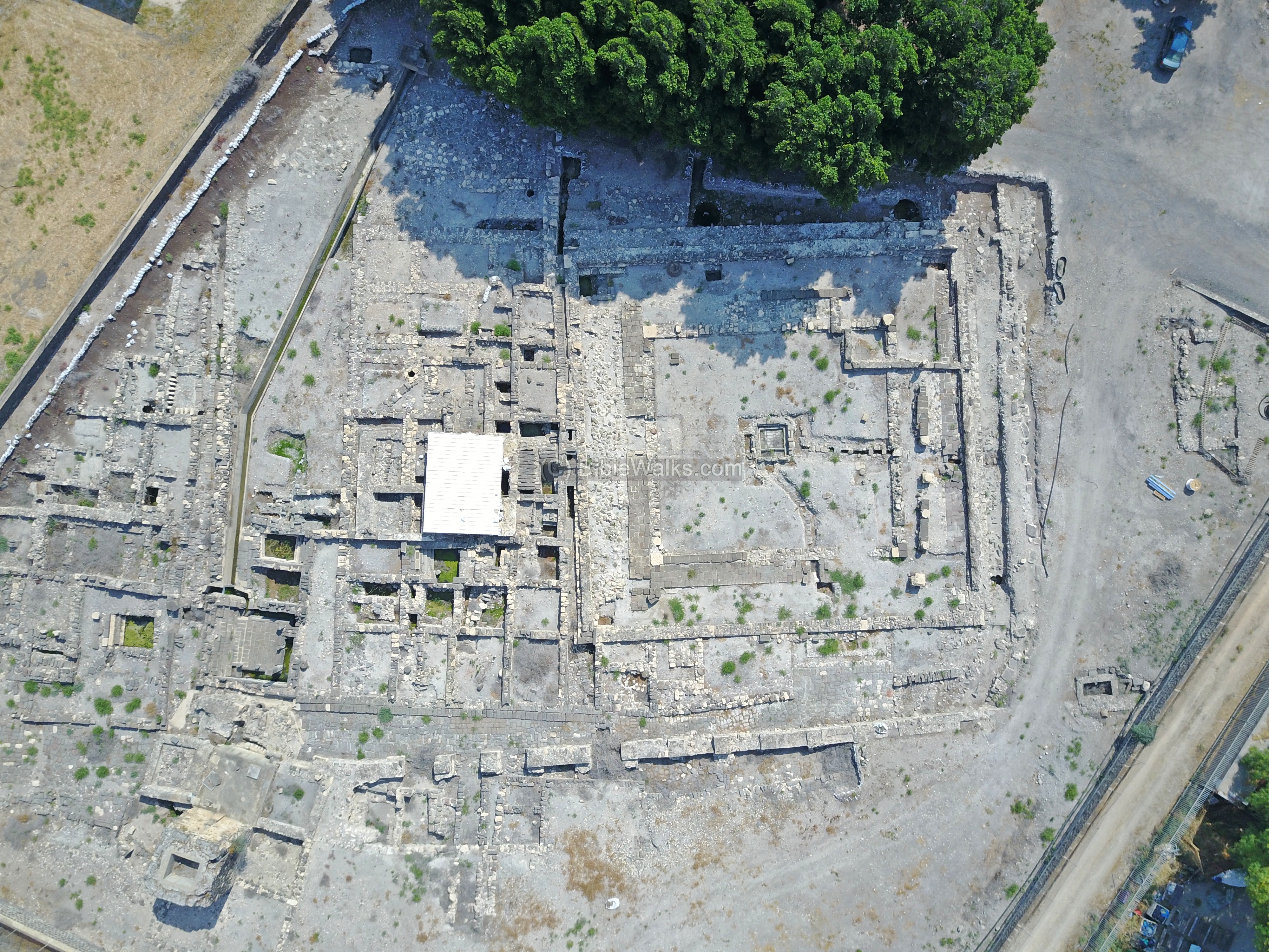 Aerial View of Areas C,D, E, and F
click on image to open a high res magnifiable version in a new tab Used with permission from from biblewalks.com |
Fig. 10 Elevation and Sections of the Hasmonean Mooring Place and of the Early Roman Inner Basin, with mooring stones (MS 1 and 4) in situ. Courtesy of S. De Luca © Magdala Project (S. De Luca 2008) JW: See units 3-4 to the left of middle drawing (under F18) overlain by an apparent collapse layer De Luca and Lena (2014)
Fig. 20Geological Space-Time Depositional Evolution Scheme of the Harbors of Magdala–Taricheae. Courtesy of G. Sarti, University of Pisa © Magdala Project – University of Pisa (G. Sarti 2011) De Luca and Lena (2014) |
|
|
Areas H1, H2, and H3
Plate 6 Plan of excavation areas H1, H2, and H3, at the end of the 2007 season of the Magdala Project (S. De Luca—A. Ricci; relief from M. Forgia, A. Faggi, and B. Stern). De Luca (2009
Plate 7Magdala/Taricheae, Area H1. Survey of the wall structures and collapses with indication of the main US and USM (S. De Luca—M. Forgia). De Luca (2009
Plate 8Magdala/Taricheae, Area H2. Survey of the wall structures and collapses with indication of the main US and USM (S. De Luca—A. Faggi). De Luca (2009
Plate 9Magdala/Taricheae, Area H3. Survey of the wall structures and collapses with indication of the main US and USM (S. De Luca—B. Stern). De Luca (2009 |
Fig. 8 General photo of Area H1 at the end of the excavation. Towards the West (D. Zanetti © Magdala Project) De Luca (2009)
Fig. 25 (top)General photo of Area H2 at the end of the excavation. Towards the East (D. Zanetti © Magdala Project) Fig. 26 (bottom) Aerial photo of Area H2 at the end of the excavation. (Skyview, © Magdala Project) De Luca (2009)
Fig. 39Aerial photo of Area H3 at the end of the excavation. (Skyview © Magdala Project) De Luca (2009)
Fig. 28Excavation documentation of Area H2 South East sector. Detail of the covered conduit USM 60-61-116 under the paved road USM 5. Towards the North (D. Zanetti © Magdala Project) De Luca (2009)
Fig. 30Excavation documentation of Area H2 South East sector. On the left: behind the covered conduit USM 60-61-116, you can see the US 59 alignment, the US 52 floor preparation, covered by the US 34 layer. On the right : remains of the paving of the USM 5 street. Towards the West (D. Zanetti © Magdala Project) De Luca (2009)
Fig. 35Excavation documentation of Area H2 North West sector. Detail of the particular elements of the US 13 collapse, in the US 24 destruction layer, against the USM 17 façade wall. Southward (Skyview © Magdala Project) De Luca (2009)
Fig. 42Excavation documentation of Area H3 Northern sector. Detail of the collapsing structures USM 50, near USM 47 on the left, and USM 48 behind. Towards the South. (D. Zanetti © Magdala Project) De Luca (2009) |
|
- Modified by JW from Fig.s 4 and 10 of de Luca and Lena (2014)
 Deformation Map
Modified by JW from Fig.s 4 and 10 of de Luca and Lena (2014)
-
Earthquake Archeological Effects chart
of Rodríguez-Pascua et al (2013: 221-224)
 Earthquake Archeological Effects (EAE)
Rodríguez-Pascua et al (2013: 221-224)
| Effect | Location | Image(s) | Description | Intensity |
|---|---|---|---|---|
|
eastern portico including square F18 (units 3 and/or 4)
Fig. 4 Plan of the Harbors Structures. Magdala Project 2007–2011 Excavations Color Code
Courtesy of S. De Luca © Magdala Project 2011–2012 (S. De Luca – A. Ricci) De Luca and Lena (2014)
Fig. 5Schematic Plan of the Byzantine Harbor of Magdala (Adapted from Raban 1988, fig. 7). Courtesy of S. De Luca © Magdala Project 2011–2012 (S. De Luca – A. Ricci) De Luca and Lena (2014)
Aerial View of Areas C,D, E, and Fclick on image to open a high res magnifiable version in a new tab Used with permission from from biblewalks.com |
Fig. 10 Elevation and Sections of the Hasmonean Mooring Place and of the Early Roman Inner Basin, with mooring stones (MS 1 and 4) in situ. Courtesy of S. De Luca © Magdala Project (S. De Luca 2008) JW: See units 3-4 to the left of middle drawing (under F18) overlain by an apparent collapse layer De Luca and Lena (2014)
Fig. 20Geological Space-Time Depositional Evolution Scheme of the Harbors of Magdala–Taricheae. Courtesy of G. Sarti, University of Pisa © Magdala Project – University of Pisa (G. Sarti 2011) De Luca and Lena (2014) |
|
|