Khirbet en-Nahas
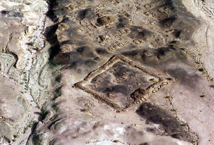 Fig. 2.2
Detailed aerial view of the northern half of Khirbat en-Nahas (view south) before the UCSD excavations took place. The photograph was taken in 1999 and shows the unexcavated gate house (Area A) associated with the fortress and the rubble rock pile indicating the monumental building (Area R) at the site directly south of the fortress. A small secondary drainage (left) bordering the eastern side of KEN. Down- cutting of this drainage eroded parts of the site, including slag mounds and other features.
Photo: UC San Diego Levantine Archaeology Laboratory; Helicopter courtesy of HRM Queen Noor Al-Hussein and the Royal Jordanian Air Force.
click on image to open in a new tab
Levy et al. (2014)
| Transliterated Name | Source | Name |
|---|---|---|
| Khirbet en-Nahas | Arabic | خربة النحاس |
| Khirbat en-Nahas | Arabic | خربة النحاس |
| Khirbet al-Nahas | Arabic | خربة النحاس |
| Khirbat al-Nahas | Arabic | خربة النحاس |
| Khirbat an-Nahas | Arabic | خربة النحاس |
| Nahas | Arabic | النحاس |
| Neḥoshet Edom | Hebrew (biblical scholarship) | נְחֹשֶׁת אֱדוֹם |
| Neḥoshet | Hebrew | נְחֹשֶׁת |
| Chalkos | Greek | χαλκός |
| Cuprum | Latin | cuprum |
| KEN | English (archaeological abbreviation) | |
| Nahas Fortress | English | |
| Slag Mound Fortress | English |
- Fig. 2.2 Aerial View of Khirbet en-Nahas
from Levy et al. (2014)
Fig. 2.2
Detailed aerial view of the northern half of Khirbat en-Nahas (view south) before the UCSD excavations took place. The photograph was taken in 1999 and shows the unexcavated gate house (Area A) associated with the fortress and the rubble rock pile indicating the monumental building (Area R) at the site directly south of the fortress. A small secondary drainage (left) bordering the eastern side of KEN. Down- cutting of this drainage eroded parts of the site, including slag mounds and other features.
Photo: UC San Diego Levantine Archaeology Laboratory; Helicopter courtesy of HRM Queen Noor Al-Hussein and the Royal Jordanian Air Force.
click on image to open in a new tab
Levy et al. (2014) - Fig. 2.3 Aerial View of Khirbet en-Nahas
with excavation areas labelled from Levy et al. (2014)
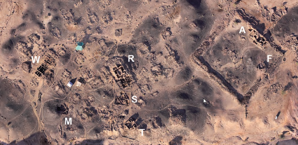 Fig. 2.3
Overview of Khirbat en-Nahas taken with the ELRAP helium balloon platform showing the seven excavation areas, 2009 season.
Photo: UC San Diego Levantine Archaeology Laboratory.
click on image to open in a new tab
Levy et al. (2014) - Fig. 2.4b Satellite View of Khirbat en-Nahas
with excavation areas from Levy et al. (2014)
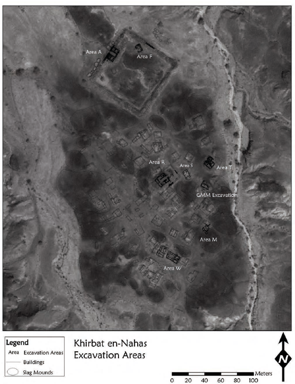 Fig. 2.4b
GeoEye satellite image of Khirbat en-Nahas with excavation areas.
click on image to open in a new tab
Levy et al. (2014) - Khirbet en-Nahas in Google Earth
 Khirbet en-Nahas in Google Earth
click on image to explore this site on a new tab in Google Earth
- Fig. 2.2 Aerial View of Khirbet en-Nahas
from Levy et al. (2014)
Fig. 2.2
Detailed aerial view of the northern half of Khirbat en-Nahas (view south) before the UCSD excavations took place. The photograph was taken in 1999 and shows the unexcavated gate house (Area A) associated with the fortress and the rubble rock pile indicating the monumental building (Area R) at the site directly south of the fortress. A small secondary drainage (left) bordering the eastern side of KEN. Down- cutting of this drainage eroded parts of the site, including slag mounds and other features.
Photo: UC San Diego Levantine Archaeology Laboratory; Helicopter courtesy of HRM Queen Noor Al-Hussein and the Royal Jordanian Air Force.
click on image to open in a new tab
Levy et al. (2014) - Fig. 2.3 Aerial View of Khirbet en-Nahas
with excavation areas labelled from Levy et al. (2014)
Fig. 2.3
Overview of Khirbat en-Nahas taken with the ELRAP helium balloon platform showing the seven excavation areas, 2009 season.
Photo: UC San Diego Levantine Archaeology Laboratory.
click on image to open in a new tab
Levy et al. (2014) - Fig. 2.4b Satellite View of Khirbat en-Nahas
with excavation areas from Levy et al. (2014)
Fig. 2.4b
GeoEye satellite image of Khirbat en-Nahas with excavation areas.
click on image to open in a new tab
Levy et al. (2014) - Khirbet en-Nahas in Google Earth
Khirbet en-Nahas in Google Earth
click on image to explore this site on a new tab in Google Earth
- Fig. 2.3 Aerial View of Khirbet en-Nahas
with excavation areas labelled from Levy et al. (2014)
Fig. 2.3
Overview of Khirbat en-Nahas taken with the ELRAP helium balloon platform showing the seven excavation areas, 2009 season.
Photo: UC San Diego Levantine Archaeology Laboratory.
click on image to open in a new tab
Levy et al. (2014) - Fig. 2.4a Topographic map of Khirbat en-Nahas
with excavation areas and architectural units from Levy et al. (2014)
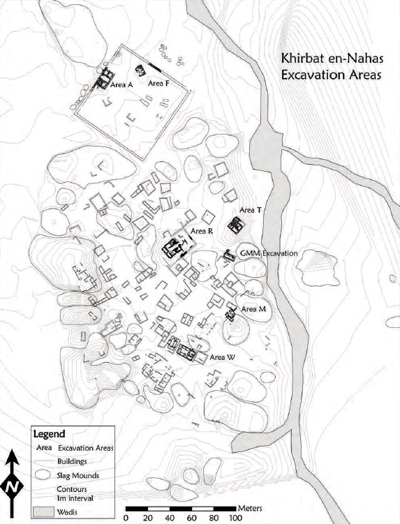 Fig. 2.4a
Topographic map of Khirbat en-Nahas with excavation areas and architectural units visible on the site surface.
click on image to open in a new tab
Levy et al. (2014) - Fig. 2.4b Satellite View of Khirbat en-Nahas
with excavation areas from Levy et al. (2014)
Fig. 2.4b
GeoEye satellite image of Khirbat en-Nahas with excavation areas.
click on image to open in a new tab
Levy et al. (2014)
- Fig. 2.3 Aerial View of Khirbet en-Nahas
with excavation areas labelled from Levy et al. (2014)
Fig. 2.3
Overview of Khirbat en-Nahas taken with the ELRAP helium balloon platform showing the seven excavation areas, 2009 season.
Photo: UC San Diego Levantine Archaeology Laboratory.
click on image to open in a new tab
Levy et al. (2014) - Fig. 2.4a Topographic map of Khirbat en-Nahas
with excavation areas and architectural units from Levy et al. (2014)
Fig. 2.4a
Topographic map of Khirbat en-Nahas with excavation areas and architectural units visible on the site surface.
click on image to open in a new tab
Levy et al. (2014) - Fig. 2.4b Satellite View of Khirbat en-Nahas
with excavation areas from Levy et al. (2014)
Fig. 2.4b
GeoEye satellite image of Khirbat en-Nahas with excavation areas.
click on image to open in a new tab
Levy et al. (2014)
- Fig. 2.6 Plan of Area A gatehouse
from Levy et al. (2014)
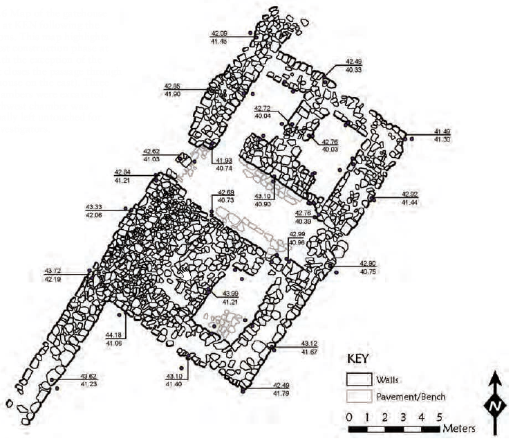 Fig. 2.6
Map of the gatehouse (Area A) at KEN following the excavations. This map highlights the earliest construction phase at KEN (with the exception of the wall that closes the passage through the gatehouse on the east). Three of the chambers were excavated. The southwest chamber was intentionally left untouched for future investigators.
click on image to open in a new tab
Levy et al. (2014) - Fig. 2.7 Overview of the gatehouse
excavations in Area A from Levy et al. (2014)
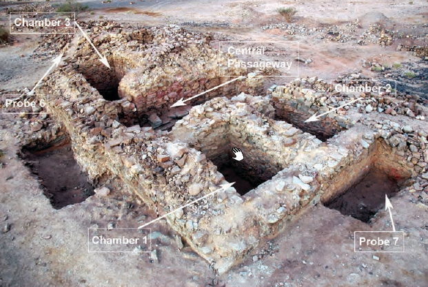 Fig. 2.7
Overview of the gatehouse excavations in Area A at Khirbat en-Nahas following the 2006 UCSD ELRAP expedition.
Photo: T.E. Levy, UC San Diego Levantine Archaeology Laboratory.
click on image to open in a new tab
Levy et al. (2014)
- Fig. 2.6 Plan of Area A gatehouse
from Levy et al. (2014)
Fig. 2.6
Map of the gatehouse (Area A) at KEN following the excavations. This map highlights the earliest construction phase at KEN (with the exception of the wall that closes the passage through the gatehouse on the east). Three of the chambers were excavated. The southwest chamber was intentionally left untouched for future investigators.
click on image to open in a new tab
Levy et al. (2014) - Fig. 2.7 Overview of the gatehouse
excavations in Area A from Levy et al. (2014)
Fig. 2.7
Overview of the gatehouse excavations in Area A at Khirbat en-Nahas following the 2006 UCSD ELRAP expedition.
Photo: T.E. Levy, UC San Diego Levantine Archaeology Laboratory.
click on image to open in a new tab
Levy et al. (2014)
- Fig. 2.8 Stone collapse on top
of the gatehouse prior to excavation from Levy et al. (2014)
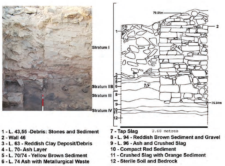 Fig. 2.8
Stratigraphic profile in Chamber 1 of the Khirbat en-Nahas gatehouse, 2002 excavation season.
Photo: T.E. Levy, UC San Diego Levantine Archaeology Laboratory
click on image to open in a new tab
Levy et al. (2014)
- Fig. 2.8 Stone collapse on top
of the gatehouse prior to excavation from Levy et al. (2014)
Fig. 2.8
Stratigraphic profile in Chamber 1 of the Khirbat en-Nahas gatehouse, 2002 excavation season.
Photo: T.E. Levy, UC San Diego Levantine Archaeology Laboratory
click on image to open in a new tab
Levy et al. (2014)
- Fig. 2.5 Stone collapse on top
of the gatehouse prior to excavation from Levy et al. (2014)
 Fig. 2.5
Overview of the stone collapse on top of the gatehouse at KEN prior to excavation in 2002.
Photo: T.E. Levy, UC San Diego Levantine Archaeology Laboratory
click on image to open in a new tab
Levy et al. (2014) - Fig. 2.7 Overview of the gatehouse
excavations in Area A from Levy et al. (2014)
Fig. 2.7
Overview of the gatehouse excavations in Area A at Khirbat en-Nahas following the 2006 UCSD ELRAP expedition.
Photo: T.E. Levy, UC San Diego Levantine Archaeology Laboratory.
click on image to open in a new tab
Levy et al. (2014) - Fig. 2.16 Layers A1b and A2a in Area A
from Levy et al. (2014)
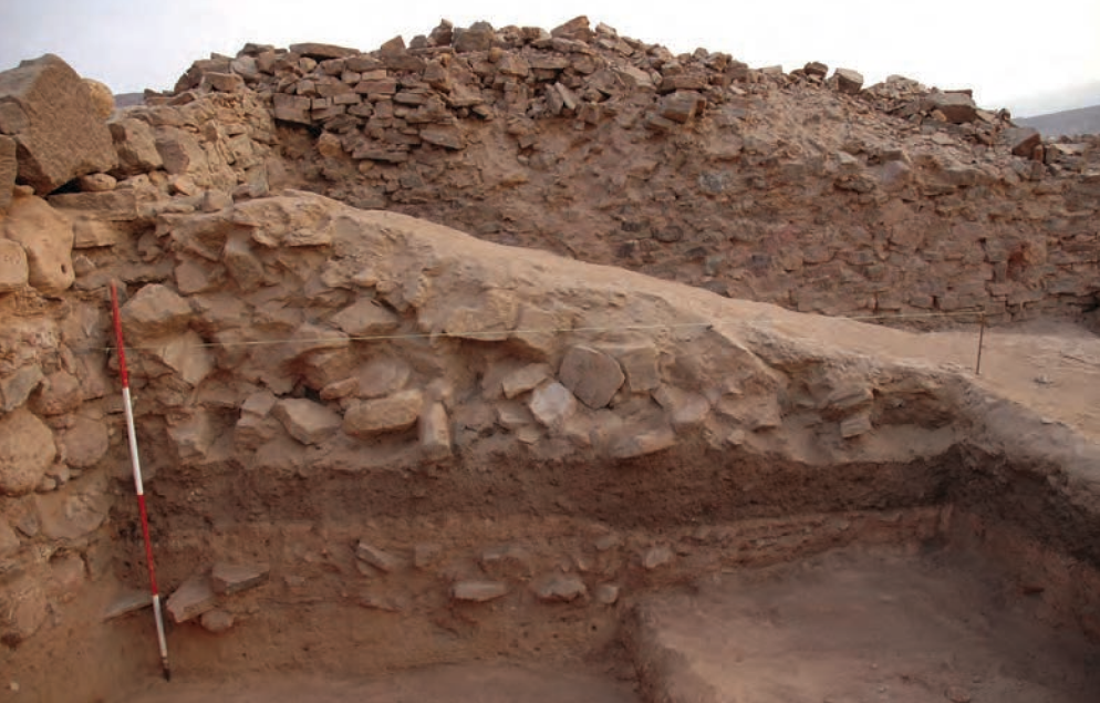 Fig. 2.16
The northern section of the southern Probe 6 with the gatehouse in the background. Above: the debris from the com- pound wall. Layer A2a is represented by the dark layer sandwiched beneath the debris from the fortifcation wall (seen on left) and the lighter tenth-century BCE material associated with the base of this massive wall.
Photo: T.E. Levy, UC San Diego Levantine Archaeology Laboratory.
click on image to open in a new tab
Levy et al. (2014) - Fig. 2.17 Layers A1b and A2a in Area A
from Levy et al. (2014)
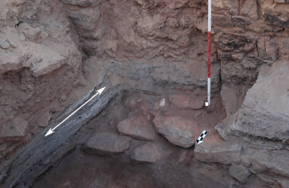 Fig. 2.17
Layer A2a industrial ash layers under the superstructure debris layer (A1b), eastern end of the central passageway interior.
Photo: T.E. Levy, UC San Diego Levantine Archaeology Laboratory.
click on image to open in a new tab
Levy et al. (2014) - Fig. 2.23 Tilted Wall at
the gatehouse from Levy et al. (2014)
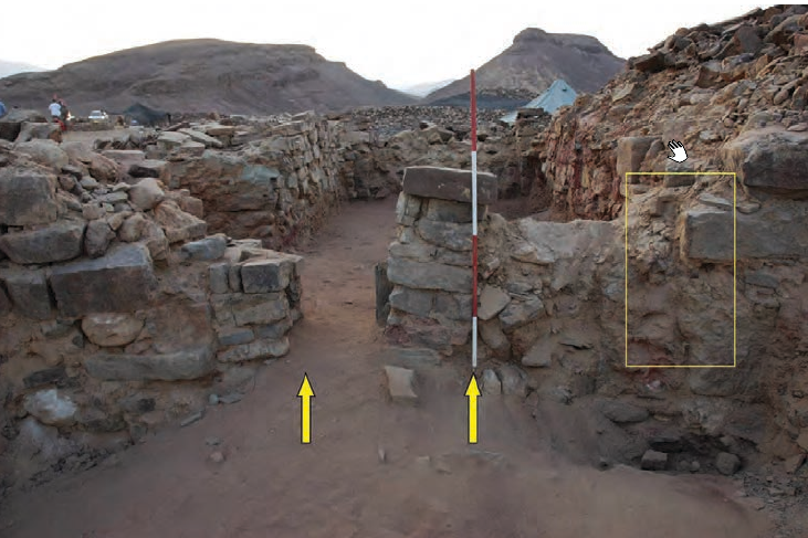 Fig. 2.23
The three A3a pilasters at the gate’s entrance that would have prevented the entrance of large animals and wheeled vehicles into the gatehouse passageway.
Photo: T.E. Levy, UC San Diego Levantine Archaeology Laboratory.
click on image to open in a new tab
Levy et al. (2014)
- Fig. 2.5 Stone collapse on top
of the gatehouse prior to excavation from Levy et al. (2014)
Fig. 2.5
Overview of the stone collapse on top of the gatehouse at KEN prior to excavation in 2002.
Photo: T.E. Levy, UC San Diego Levantine Archaeology Laboratory
click on image to open in a new tab
Levy et al. (2014) - Fig. 2.7 Overview of the gatehouse
excavations in Area A from Levy et al. (2014)
Fig. 2.7
Overview of the gatehouse excavations in Area A at Khirbat en-Nahas following the 2006 UCSD ELRAP expedition.
Photo: T.E. Levy, UC San Diego Levantine Archaeology Laboratory.
click on image to open in a new tab
Levy et al. (2014) - Fig. 2.16 Layers A1b and A2a in Area A
from Levy et al. (2014)
Fig. 2.16
The northern section of the southern Probe 6 with the gatehouse in the background. Above: the debris from the com- pound wall. Layer A2a is represented by the dark layer sandwiched beneath the debris from the fortifcation wall (seen on left) and the lighter tenth-century BCE material associated with the base of this massive wall.
Photo: T.E. Levy, UC San Diego Levantine Archaeology Laboratory.
click on image to open in a new tab
Levy et al. (2014) - Fig. 2.17 Layers A1b and A2a in Area A
from Levy et al. (2014)
Fig. 2.17
Layer A2a industrial ash layers under the superstructure debris layer (A1b), eastern end of the central passageway interior.
Photo: T.E. Levy, UC San Diego Levantine Archaeology Laboratory.
click on image to open in a new tab
Levy et al. (2014) - Fig. 2.23 Tilted Wall at
the gatehouse from Levy et al. (2014)
Fig. 2.23
The three A3a pilasters at the gate’s entrance that would have prevented the entrance of large animals and wheeled vehicles into the gatehouse passageway.
Photo: T.E. Levy, UC San Diego Levantine Archaeology Laboratory.
click on image to open in a new tab
Levy et al. (2014)
- from Levy et al. (2014)
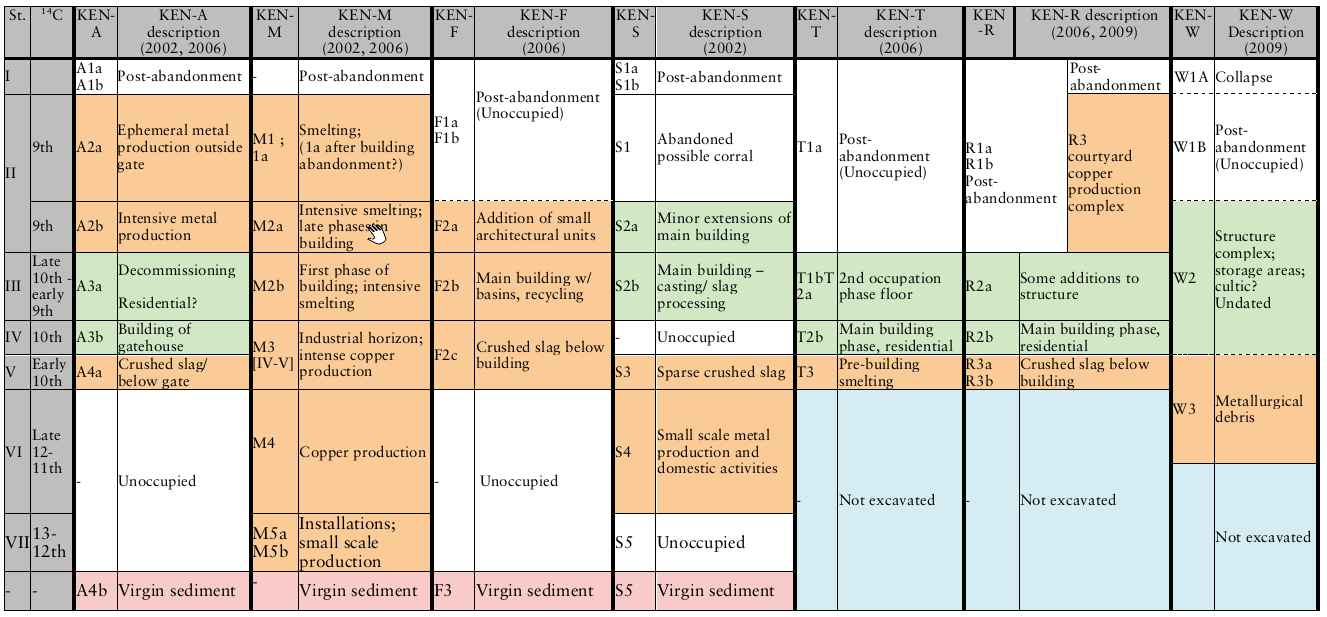 Table 2.1
Correlation of Strata from all Excavation Areas (A, M, F, S, T, R and W) at Khirbat en-Nahas. The Roman numerals in the first column (St. = Stratum) represent the general strata that are used to compare these different areas at the site. The main tool for correlating cross-cutting contexts was the high resolution radiocarbon dating. Color key:
- white = unoccupied / post-abandonment context
- orange = mainly smelting and other pyrotechnological activities
- green = mainly architectural remains (buildings)
- blue = unexcavated contexts; pink = virgin soil
Click on Image to open in a new tab
Levy et al. (2014)
- from Levy et al. (2014)
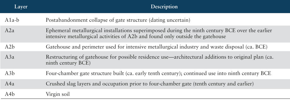 Table 2.2
Stratigraphic layers in Area A, KEN.
Click on Image to open in a new tab
Levy et al. (2014)
- from Levy et al. (2014)
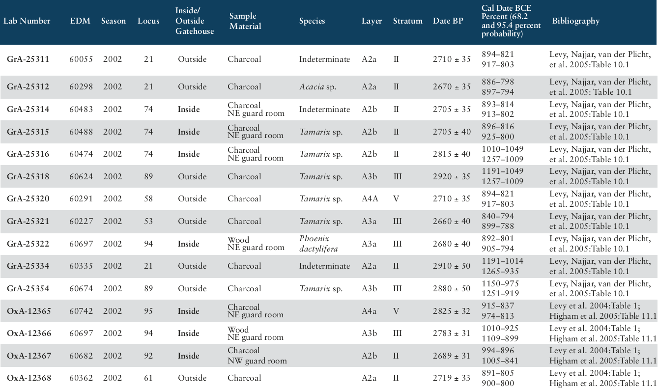
 Table 2.1
Radiocarbon dates from 2002 and 2006 excavations at Area A gatehouse, Khirbat en-Nahas.
Click on either image to open in a new tab
Levy et al. (2014)
| Damage Type | Location | Image(s) | Comments |
|---|---|---|---|
| Debris (due to collapsed walls) | Area A
Fig. 2.4a
Topographic map of Khirbat en-Nahas with excavation areas and architectural units visible on the site surface. click on image to open in a new tab Levy et al. (2014)
Fig. 2.6
Map of the gatehouse (Area A) at KEN following the excavations. This map highlights the earliest construction phase at KEN (with the exception of the wall that closes the passage through the gatehouse on the east). Three of the chambers were excavated. The southwest chamber was intentionally left untouched for future investigators. click on image to open in a new tab Levy et al. (2014)
Fig. 2.7
Overview of the gatehouse excavations in Area A at Khirbat en-Nahas following the 2006 UCSD ELRAP expedition. Photo: T.E. Levy, UC San Diego Levantine Archaeology Laboratory. click on image to open in a new tab Levy et al. (2014) |
Fig. 2.16
The northern section of the southern Probe 6 with the gatehouse in the background. Above: the debris from the com- pound wall. Layer A2a is represented by the dark layer sandwiched beneath the debris from the fortifcation wall (seen on left) and the lighter tenth-century BCE material associated with the base of this massive wall. Photo: T.E. Levy, UC San Diego Levantine Archaeology Laboratory. click on image to open in a new tab Levy et al. (2014)
Fig. 2.17
Layer A2a industrial ash layers under the superstructure debris layer (A1b), eastern end of the central passageway interior. Photo: T.E. Levy, UC San Diego Levantine Archaeology Laboratory. click on image to open in a new tab Levy et al. (2014) |
|
- Earthquake Archeological Effects chart
of Rodríguez-Pascua et al (2013: 221-224)
 Earthquake Archeological Effects (EAE)
Rodríguez-Pascua et al (2013: 221-224)
| Damage Type | Location | Image(s) | Comments | Intensity |
|---|---|---|---|---|
| Debris (due to collapsed walls) | Area A
Fig. 2.4a
Topographic map of Khirbat en-Nahas with excavation areas and architectural units visible on the site surface. click on image to open in a new tab Levy et al. (2014)
Fig. 2.6
Map of the gatehouse (Area A) at KEN following the excavations. This map highlights the earliest construction phase at KEN (with the exception of the wall that closes the passage through the gatehouse on the east). Three of the chambers were excavated. The southwest chamber was intentionally left untouched for future investigators. click on image to open in a new tab Levy et al. (2014)
Fig. 2.7
Overview of the gatehouse excavations in Area A at Khirbat en-Nahas following the 2006 UCSD ELRAP expedition. Photo: T.E. Levy, UC San Diego Levantine Archaeology Laboratory. click on image to open in a new tab Levy et al. (2014) |
Fig. 2.16
The northern section of the southern Probe 6 with the gatehouse in the background. Above: the debris from the com- pound wall. Layer A2a is represented by the dark layer sandwiched beneath the debris from the fortifcation wall (seen on left) and the lighter tenth-century BCE material associated with the base of this massive wall. Photo: T.E. Levy, UC San Diego Levantine Archaeology Laboratory. click on image to open in a new tab Levy et al. (2014)
Fig. 2.17
Layer A2a industrial ash layers under the superstructure debris layer (A1b), eastern end of the central passageway interior. Photo: T.E. Levy, UC San Diego Levantine Archaeology Laboratory. click on image to open in a new tab Levy et al. (2014) |
|
VIII+ |