Khirbet Wadi Hamam
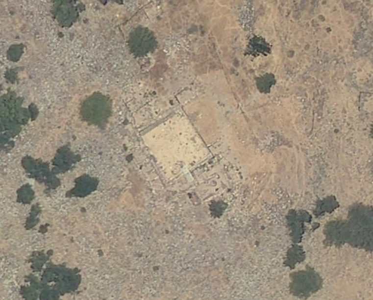 Aerial View of Khirbet Wadi Hamam on govmap.gov.il
Click on Image to explore this site on a new tab in govmap.gov.il
| Transliterated Name | Source | Name |
|---|---|---|
| Khirbet Wadi Hamam | | |
| Hamaam | Hebrew | חַמָּם |
| Horvat Veredim | Hebrew | |
| Hamaam | Arabic | حمام |
| Mazraʿat Mugr al Hamam | Arabic | |
| Khirbet el-Wereidat | Arabic | |
| Wadi Hamam | Arabic | |
| Migdal Zabaʿayya ? | Aramaic | |
- Orientation Map from
Uzi Leibner
 Orientation Map
click on image to open in a new tab
Uzi Leibner
- Fig. 1.5 Aerial photo showing
Khirbet Wadi Ḥamam and surroundings from Leibner et al. (2018)
 Fig. 1.5
Aerial photo of the British Royal Air Force showing Kh. Wadi Ḥamam and its surroundings; note the Beduin huts in the foreground, on both sides of Wadi Arbel (Photo ID 5141, January, 4, 1945; courtesy of the Aerial Photos Archive Digitizing Project, The Center for Computational Geography, The Dept. of Geography, The Hebrew University (2010).
click on image to open in a new tab
Leibner et al. (2018) - Fig. 6.61 Aerial view of Area
C prior to excavation from Leibner et al. (2018)
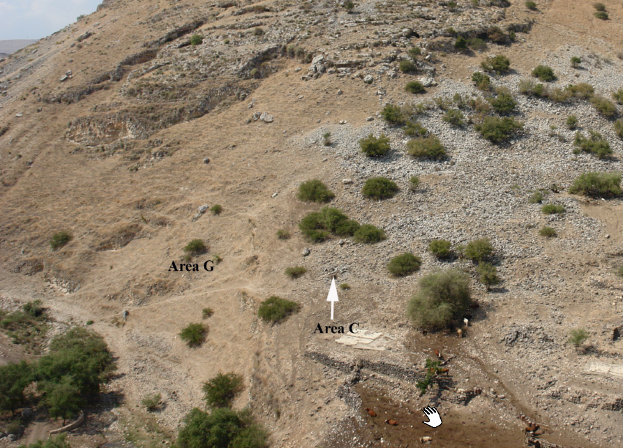 Fig. 6.61
Aerial view of Area C prior to excavation, looking southwest.
click on image to open in a new tab
Leibner et al. (2018) - Khirbet Wadi Hamam in Google Earth
 Khirbet Wadi Hamam in Google Earth
click on image to explore this site on a new tab in Google Earth - Khirbet Wadi Hamam on govmap.gov.il
Khirbet Wadi Hamam on govmap.gov.il
click on image to explore this site on a new tab in govmap.gov.il
- Fig. 1.5 Aerial photo showing
Khirbet Wadi Ḥamam and surroundings from Leibner et al. (2018)
Fig. 1.5
Aerial photo of the British Royal Air Force showing Kh. Wadi Ḥamam and its surroundings; note the Beduin huts in the foreground, on both sides of Wadi Arbel (Photo ID 5141, January, 4, 1945; courtesy of the Aerial Photos Archive Digitizing Project, The Center for Computational Geography, The Dept. of Geography, The Hebrew University (2010).
click on image to open in a new tab
Leibner et al. (2018) - Fig. 6.61 Aerial view of Area
C prior to excavation from Leibner et al. (2018)
Fig. 6.61
Aerial view of Area C prior to excavation, looking southwest.
click on image to open in a new tab
Leibner et al. (2018) - Khirbet Wadi Hamam in Google Earth
Khirbet Wadi Hamam in Google Earth
click on image to explore this site on a new tab in Google Earth - Khirbet Wadi Hamam on govmap.gov.il
Khirbet Wadi Hamam on govmap.gov.il
click on image to explore this site on a new tab in govmap.gov.il
- Map of excavation areas
from Uzi Leibner
 Map of excavation areas in Khirbet Wadi Hamam and surroundings
click on image to open in a new tab
Uzi Leibner
- Map of excavation areas
from Uzi Leibner
Map of excavation areas in Khirbet Wadi Hamam and surroundings
click on image to open in a new tab
Uzi Leibner
- Fig. 1.8 Block plan of Areas
A, B, and C from Leibner et al. (2018)
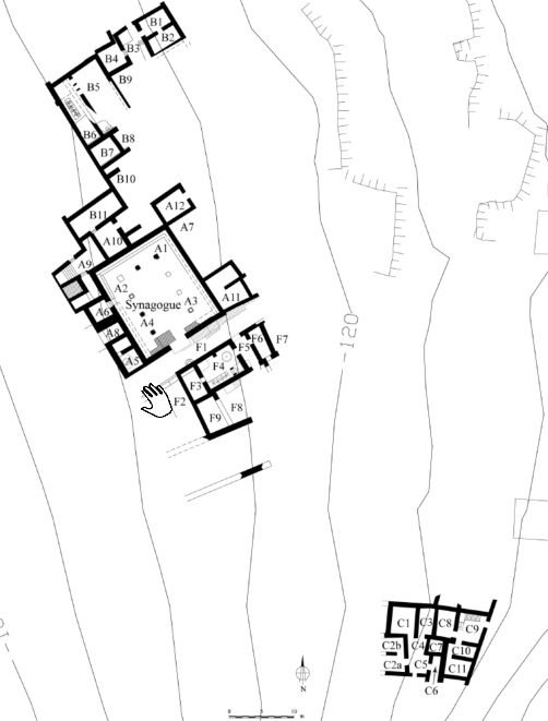 Fig. 1.8
Block plan of the Kh. Wadi Ḥamam excavations showing the division into units (drawing by Marcos Edelcopp).
click on image to open in a new tab
Leibner et al. (2018)
- Fig. 1.8 Block plan of Areas
A, B, and C from Leibner et al. (2018)
Fig. 1.8
Block plan of the Kh. Wadi Ḥamam excavations showing the division into units (drawing by Marcos Edelcopp).
click on image to open in a new tab
Leibner et al. (2018)
- Fig. 2.2 Aerial view of the
synagogue area after excavations from Leibner et al. (2018)
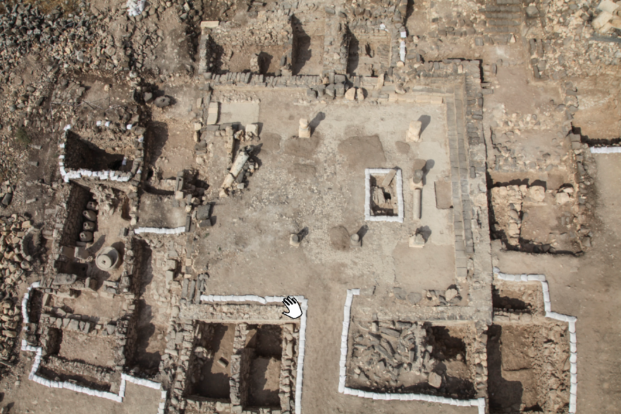 Fig. 2.2
Aerial view of the synagogue area after excavations. Note the same northeastern pedestal on the bottom right.
click on image to open in a new tab
Leibner et al. (2018) - Fig. 2.4 Block plan of Synagogue
II and surrounding Stratum 2 structures and alleys from Leibner et al. (2018)
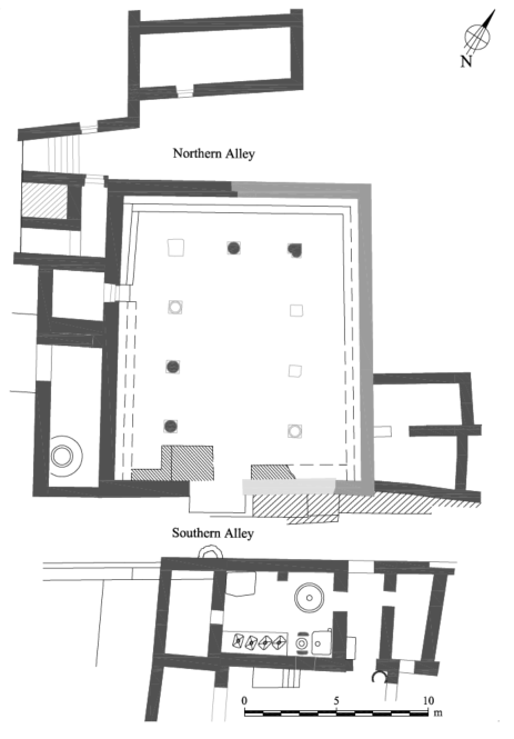 Fig. 2.4
Block plan of Synagogue II and surrounding Stratum 2 structures and alleys
- black: surviving remains of Synagogue I
- dark gray: walls constructed in Synagogue II
- light gray: repairs in Sub-Phase Ilb
- raster: retaining wall built on the southern alley
click on image to open in a new tab
Leibner et al. (2018) - Fig. 2.5 Block plan of the
synagogue showing the excavation areas (A, B, F), units, soundings and the major section lines from Leibner et al. (2018)
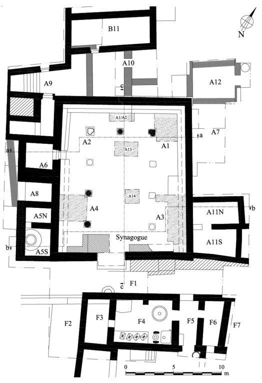 Fig. 2.5
Block plan of the synagogue (in black) showing the excavation areas (A, B, F), units, soundings (dotted raster) and the major section lines through the building
- lined raster: Sub-Phase Ilb
- gray: Stratum 3 walls
- soundings: dotted raster
click on image to open in a new tab
Leibner et al. (2018) - Fig. 2.7 Detailed plan of
the synagogue showing wall and column numbers and major locus numbers from Leibner et al. (2018)
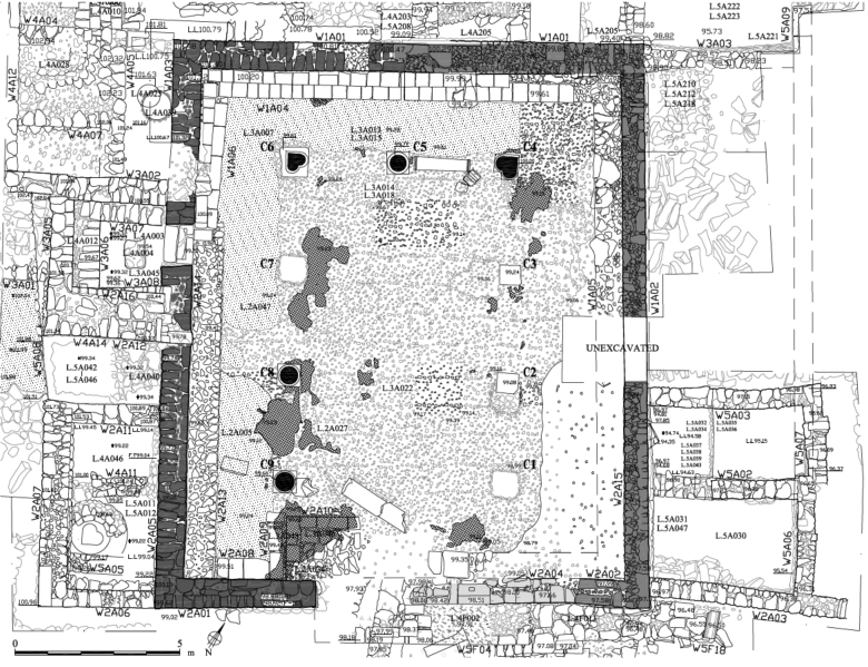 Fig. 2.7
Detailed plan of the synagogue showing wall and column numbers and major locus numbers.
click on image to open in a new tab
Leibner et al. (2018)
- Fig. 2.2 Aerial view of the
synagogue area after excavations from Leibner et al. (2018)
Fig. 2.2
Aerial view of the synagogue area after excavations. Note the same northeastern pedestal on the bottom right.
click on image to open in a new tab
Leibner et al. (2018) - Fig. 2.4 Block plan of Synagogue
II and surrounding Stratum 2 structures and alleys from Leibner et al. (2018)
Fig. 2.4
Block plan of Synagogue II and surrounding Stratum 2 structures and alleys
- black: surviving remains of Synagogue I
- dark gray: walls constructed in Synagogue II
- light gray: repairs in Sub-Phase Ilb
- raster: retaining wall built on the southern alley
click on image to open in a new tab
Leibner et al. (2018) - Fig. 2.5 Block plan of the
synagogue showing the excavation areas (A, B, F), units, soundings and the major section lines from Leibner et al. (2018)
Fig. 2.5
Block plan of the synagogue (in black) showing the excavation areas (A, B, F), units, soundings (dotted raster) and the major section lines through the building
- lined raster: Sub-Phase Ilb
- gray: Stratum 3 walls
- soundings: dotted raster
click on image to open in a new tab
Leibner et al. (2018) - Fig. 2.7 Detailed plan of
the synagogue showing wall and column numbers and major locus numbers from Leibner et al. (2018)
Fig. 2.7
Detailed plan of the synagogue showing wall and column numbers and major locus numbers.
click on image to open in a new tab
Leibner et al. (2018)
- Fig. 6.4 Aerial view of Area B
at the end of the 2011 season from Leibner et al. (2018)
 Fig. 6.4
Aerial view of Area B at the end of the 2011 season, looking west (part of the units have been backfilled)
click on image to open in a new tab
Leibner et al. (2018) - Fig. 6.1 Block plan of Area B
showing the excavation units and the major section lines from Leibner et al. (2018)
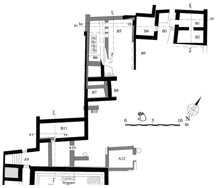 Fig. 6.1
Block plan of Area B showing the excavation units and the major section lines (black: Stratum 2; gray: Stratum 3).
click on image to open in a new tab
Leibner et al. (2018) - Fig. 6.2 Detailed plan of the
northern part of Area B showing wall numbers and major locus numbers from Leibner et al. (2018)
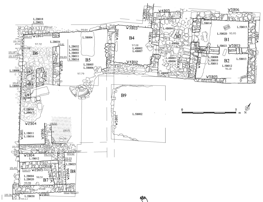 Fig. 6.2
Detailed plan of the northern part of Area B showing wall numbers and major locus numbers.
click on image to open in a new tab
Leibner et al. (2018)
- Fig. 6.4 Aerial view of Area B
at the end of the 2011 season from Leibner et al. (2018)
Fig. 6.4
Aerial view of Area B at the end of the 2011 season, looking west (part of the units have been backfilled)
click on image to open in a new tab
Leibner et al. (2018) - Fig. 6.1 Block plan of Area B
showing the excavation units and the major section lines from Leibner et al. (2018)
Fig. 6.1
Block plan of Area B showing the excavation units and the major section lines (black: Stratum 2; gray: Stratum 3).
click on image to open in a new tab
Leibner et al. (2018) - Fig. 6.2 Detailed plan of the
northern part of Area B showing wall numbers and major locus numbers from Leibner et al. (2018)
Fig. 6.2
Detailed plan of the northern part of Area B showing wall numbers and major locus numbers.
click on image to open in a new tab
Leibner et al. (2018)
- Fig. 6.63 Detailed plan of Area
C showing wall numbers and major locus numbers from Leibner et al. (2018)
 Fig. 6.63
Detailed plan of Area C showing wall numbers and major locus numbers (black: Stratum 2; gray: Stratum 3).
click on image to open in a new tab
Leibner et al. (2018) - Fig. 6.64 Block plan of Area C
showing excavation units and section lines from Leibner et al. (2018)
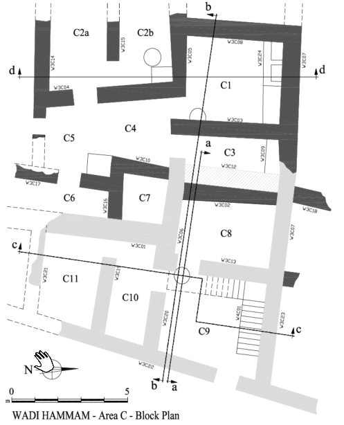 Fig. 6.64
Block plan of Area C showing excavation units and section lines (black: Stratum 2; gray: Stratum 3).
click on image to open in a new tab
Leibner et al. (2018)
- Fig. 6.63 Detailed plan of Area
C showing wall numbers and major locus numbers from Leibner et al. (2018)
Fig. 6.63
Detailed plan of Area C showing wall numbers and major locus numbers (black: Stratum 2; gray: Stratum 3).
click on image to open in a new tab
Leibner et al. (2018) - Fig. 6.64 Block plan of Area C
showing excavation units and section lines from Leibner et al. (2018)
Fig. 6.64
Block plan of Area C showing excavation units and section lines (black: Stratum 2; gray: Stratum 3).
click on image to open in a new tab
Leibner et al. (2018)
- Fig. 6.38 Aerial view of Area
F after excavation from Leibner et al. (2018)
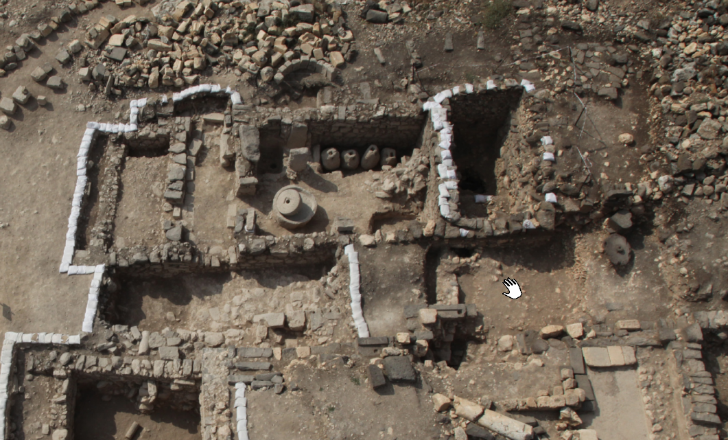 Fig. 6.38
Aerial view of Area F after excavation, looking south
click on image to open in a new tab
Leibner et al. (2018) - Fig. 6.39 Block plan of Area
F showing excavation units and major section lines from Leibner et al. (2018)
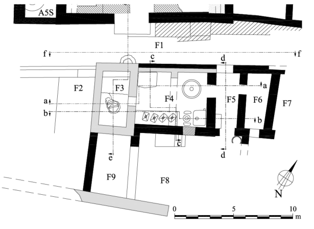 Fig. 6.39
Block plan of Area F showing excavation units and major section lines (black: Stratum 2; gray: Stratum 3).
click on image to open in a new tab
Leibner et al. (2018) - Fig. 6.40 Detailed plan of
Area F showing wall numbers and major locus numbers from Leibner et al. (2018)
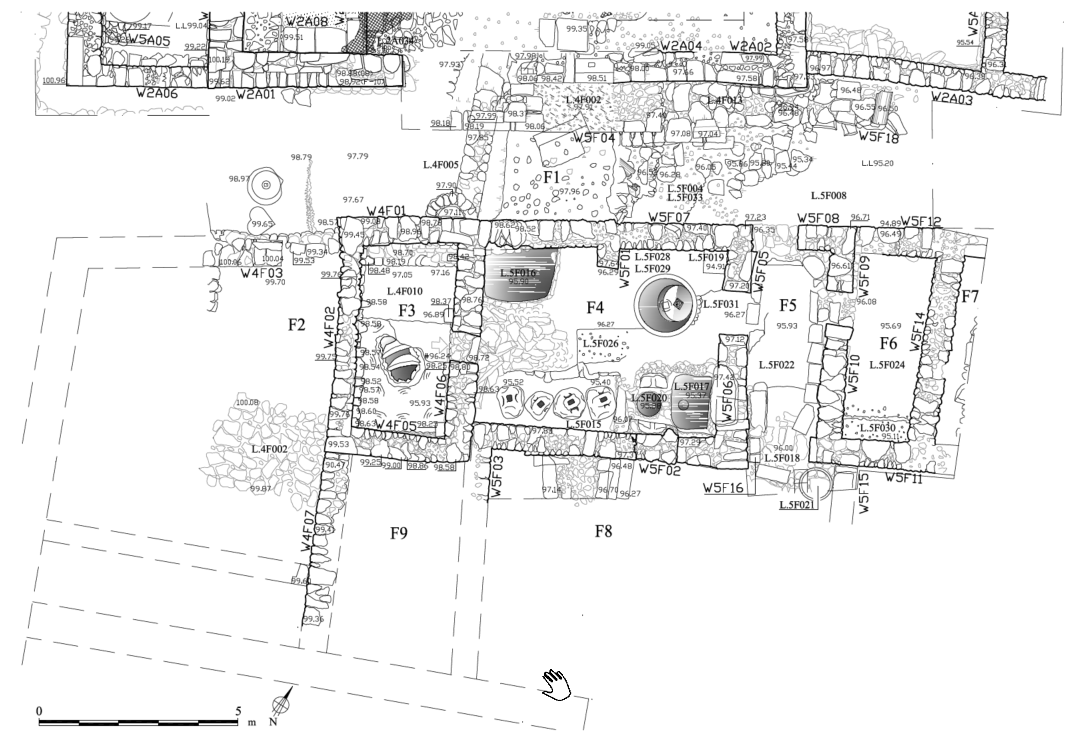 Fig. 6.40
Detailed plan of Area F showing wall numbers and major locus numbers.
click on image to open in a new tab
Leibner et al. (2018)
- Fig. 6.38 Aerial view of Area
F after excavation from Leibner et al. (2018)
Fig. 6.38
Aerial view of Area F after excavation, looking south
click on image to open in a new tab
Leibner et al. (2018) - Fig. 6.39 Block plan of Area
F showing excavation units and major section lines from Leibner et al. (2018)
Fig. 6.39
Block plan of Area F showing excavation units and major section lines (black: Stratum 2; gray: Stratum 3).
click on image to open in a new tab
Leibner et al. (2018) - Fig. 6.40 Detailed plan of
Area F showing wall numbers and major locus numbers from Leibner et al. (2018)
Fig. 6.40
Detailed plan of Area F showing wall numbers and major locus numbers.
click on image to open in a new tab
Leibner et al. (2018)
- Fig. 1.9 east–west section through
Mt. Nitai showing the topographical incline from Leibner et al. (2018)
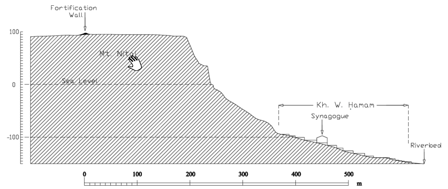 Fig. 1.9
An east–west section through Mt. Nitai showing the topographical incline (drawing by Benjamin Arubas).
click on image to open in a new tab
Leibner et al. (2018) - Fig. 2.3 east–west section through
Mt. Nitai showing the topographical incline from Leibner et al. (2018)
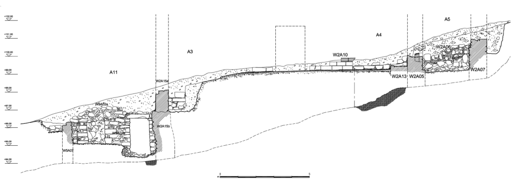 Fig. 2.3
East—west section through the southern part of the synagogue, looking south. Note the inclination of bedrock from Sounding A4 to Structure All.
click on image to open in a new tab
Leibner et al. (2018) - Fig. 2.14 east–west section through
Mt. Nitai showing the topographical incline from Leibner et al. (2018)
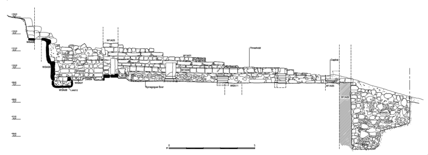 Fig. 2.14
East—west section (a-a) across the northern part of the synagogue, looking north.
click on image to open in a new tab
Leibner et al. (2018)
- Fig. 1.9 east–west section through
Mt. Nitai showing the topographical incline from Leibner et al. (2018)
Fig. 1.9
An east–west section through Mt. Nitai showing the topographical incline (drawing by Benjamin Arubas).
click on image to open in a new tab
Leibner et al. (2018) - Fig. 2.3 east–west section through
Mt. Nitai showing the topographical incline from Leibner et al. (2018)
Fig. 2.3
East—west section through the southern part of the synagogue, looking south. Note the inclination of bedrock from Sounding A4 to Structure All.
click on image to open in a new tab
Leibner et al. (2018) - Fig. 2.14 east–west section through
Mt. Nitai showing the topographical incline from Leibner et al. (2018)
Fig. 2.14
East—west section (a-a) across the northern part of the synagogue, looking north.
click on image to open in a new tab
Leibner et al. (2018)
- Fig. 1.10 Proposed reconstruction
of Kh. Wadi Ḥamam in the Late Roman period from Leibner et al. (2018)
 Fig. 1.10
Proposed reconstruction of Kh. Wadi Ḥamam in the Late Roman period, based on excavated and surveyed remains, looking west (drawing by Marcos Edelcopp).
click on image to open in a new tab
Leibner et al. (2018) - Fig. 1.11 Proposed reconstruction
of Kh. Wadi Ḥamam in the Late Roman period from Leibner et al. (2018)
 Fig. 1.11
Proposed reconstruction of Kh. Wadi Ḥamam in the Late Roman period, based on excavated and surveyed remains, looking south (drawing by Marcos Edelcopp).
click on image to open in a new tab
Leibner et al. (2018)
- Fig. 1.10 Proposed reconstruction
of Kh. Wadi Ḥamam in the Late Roman period from Leibner et al. (2018)
Fig. 1.10
Proposed reconstruction of Kh. Wadi Ḥamam in the Late Roman period, based on excavated and surveyed remains, looking west (drawing by Marcos Edelcopp).
click on image to open in a new tab
Leibner et al. (2018) - Fig. 1.11 Proposed reconstruction
of Kh. Wadi Ḥamam in the Late Roman period from Leibner et al. (2018)
Fig. 1.11
Proposed reconstruction of Kh. Wadi Ḥamam in the Late Roman period, based on excavated and surveyed remains, looking south (drawing by Marcos Edelcopp).
click on image to open in a new tab
Leibner et al. (2018)
- Fig. 2.50 Through-going fracture
in Column Pedestal in Area A from Leibner et al. (2018)
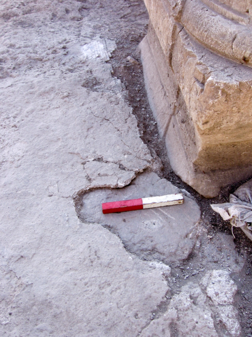 Fig. 2.50
Two layers of plaster floor in the northern aisle
click on image to open in a new tab
Leibner et al. (2018) - Fig. 2.51 coin embedded in the
plaster floor in the western aisle in Area A from Leibner et al. (2018)
 Fig. 2.51
A coin embedded in the plaster floor in the western aisle (Cat. No. 350)
click on image to open in a new tab
Leibner et al. (2018) - Fig. 2.53 collapsed wall of
synagogue in Area A from Leibner et al. (2018)
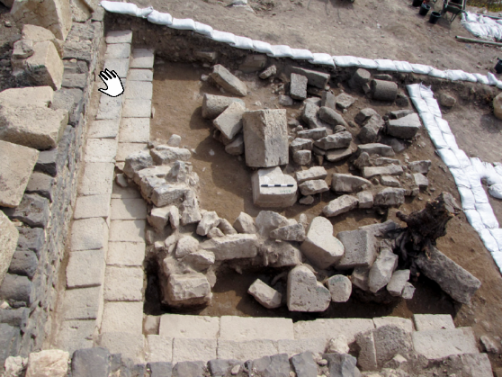 Fig. 2.53
Courses from the northern wall still bound by mortar, in the debris in the northwestern corner of the synagogue
click on image to open in a new tab
Leibner et al. (2018)
- Fig. 2.50 Through-going fracture
in Column Pedestal in Area A from Leibner et al. (2018)
Fig. 2.50
Two layers of plaster floor in the northern aisle
click on image to open in a new tab
Leibner et al. (2018) - Fig. 2.51 coin embedded in the
plaster floor in the western aisle in Area A from Leibner et al. (2018)
Fig. 2.51
A coin embedded in the plaster floor in the western aisle (Cat. No. 350)
click on image to open in a new tab
Leibner et al. (2018) - Fig. 2.53 collapsed wall of
synagogue in Area A from Leibner et al. (2018)
Fig. 2.53
Courses from the northern wall still bound by mortar, in the debris in the northwestern corner of the synagogue
click on image to open in a new tab
Leibner et al. (2018)
 Table 1.1
Summary of the Kh. Wadi Ḥamam and Mt. Nitai excavation areas: dates of occupation and structural remains.
Click on Image to open in a new tab
Leibner et al. (2018)
| Effect | Location | Image(s) | Description |
|---|---|---|---|
|
Northern Wing of Insula in Area F
Map of excavation areas in Khirbet Wadi Hamam and surroundings click on image to open in a new tab Uzi Leibner
Fig. 1.8
Block plan of the Kh. Wadi Ḥamam excavations showing the division into units (drawing by Marcos Edelcopp). click on image to open in a new tab Leibner et al. (2018)
Fig. 6.38
Aerial view of Area F after excavation, looking south click on image to open in a new tab Leibner et al. (2018)
Fig. 6.39
Block plan of Area F showing excavation units and major section lines (black: Stratum 2; gray: Stratum 3). click on image to open in a new tab Leibner et al. (2018)
Fig. 6.40
Detailed plan of Area F showing wall numbers and major locus numbers. click on image to open in a new tab Leibner et al. (2018) |
|
| Effect | Location | Image(s) | Description |
|---|---|---|---|
|
Synagogue
Map of excavation areas in Khirbet Wadi Hamam and surroundings click on image to open in a new tab Uzi Leibner
Fig. 1.8
Block plan of the Kh. Wadi Ḥamam excavations showing the division into units (drawing by Marcos Edelcopp). click on image to open in a new tab Leibner et al. (2018)
Fig. 2.2
Aerial view of the synagogue area after excavations. Note the same northeastern pedestal on the bottom right. click on image to open in a new tab Leibner et al. (2018)
Fig. 2.4
Block plan of Synagogue II and surrounding Stratum 2 structures and alleys
click on image to open in a new tab Leibner et al. (2018)
Fig. 2.5
Block plan of the synagogue (in black) showing the excavation areas (A, B, F), units, soundings (dotted raster) and the major section lines through the building
click on image to open in a new tab Leibner et al. (2018)
Fig. 2.7
Detailed plan of the synagogue showing wall and column numbers and major locus numbers. click on image to open in a new tab Leibner et al. (2018) |
|
|
|
Northeastern Domestic Complex (Units B1–B4) and Unit B8 in Area B
Map of excavation areas in Khirbet Wadi Hamam and surroundings click on image to open in a new tab Uzi Leibner
Fig. 1.8
Block plan of the Kh. Wadi Ḥamam excavations showing the division into units (drawing by Marcos Edelcopp). click on image to open in a new tab Leibner et al. (2018)
Fig. 6.4
Aerial view of Area B at the end of the 2011 season, looking west (part of the units have been backfilled) click on image to open in a new tab Leibner et al. (2018)
Fig. 6.1
Block plan of Area B showing the excavation units and the major section lines (black: Stratum 2; gray: Stratum 3). click on image to open in a new tab Leibner et al. (2018)
Fig. 6.2
Detailed plan of the northern part of Area B showing wall numbers and major locus numbers. click on image to open in a new tab Leibner et al. (2018) |
|
|
|
Upper Complex in Area C
Map of excavation areas in Khirbet Wadi Hamam and surroundings click on image to open in a new tab Uzi Leibner
Fig. 1.8
Block plan of the Kh. Wadi Ḥamam excavations showing the division into units (drawing by Marcos Edelcopp). click on image to open in a new tab Leibner et al. (2018)
Fig. 6.63
Detailed plan of Area C showing wall numbers and major locus numbers (black: Stratum 2; gray: Stratum 3). click on image to open in a new tab Leibner et al. (2018)
Fig. 6.64
Block plan of Area C showing excavation units and section lines (black: Stratum 2; gray: Stratum 3). click on image to open in a new tab Leibner et al. (2018) |
|
| Effect | Location | Image(s) | Description |
|---|---|---|---|
|
Synagogue
Map of excavation areas in Khirbet Wadi Hamam and surroundings click on image to open in a new tab Uzi Leibner
Fig. 1.8
Block plan of the Kh. Wadi Ḥamam excavations showing the division into units (drawing by Marcos Edelcopp). click on image to open in a new tab Leibner et al. (2018)
Fig. 2.2
Aerial view of the synagogue area after excavations. Note the same northeastern pedestal on the bottom right. click on image to open in a new tab Leibner et al. (2018)
Fig. 2.4
Block plan of Synagogue II and surrounding Stratum 2 structures and alleys
click on image to open in a new tab Leibner et al. (2018)
Fig. 2.5
Block plan of the synagogue (in black) showing the excavation areas (A, B, F), units, soundings (dotted raster) and the major section lines through the building
click on image to open in a new tab Leibner et al. (2018)
Fig. 2.7
Detailed plan of the synagogue showing wall and column numbers and major locus numbers. click on image to open in a new tab Leibner et al. (2018) |
Fig. 2.53
Courses from the northern wall still bound by mortar, in the debris in the northwestern corner of the synagogue click on image to open in a new tab Leibner et al. (2018) |
|
-
Earthquake Archeological Effects chart
of Rodríguez-Pascua et al (2013: 221-224)
 Earthquake Archeological Effects (EAE)
Rodríguez-Pascua et al (2013: 221-224)
| Effect | Location | Image(s) | Description | Intensity |
|---|---|---|---|---|
|
Northern Wing of Insula in Area F
Map of excavation areas in Khirbet Wadi Hamam and surroundings click on image to open in a new tab Uzi Leibner
Fig. 1.8
Block plan of the Kh. Wadi Ḥamam excavations showing the division into units (drawing by Marcos Edelcopp). click on image to open in a new tab Leibner et al. (2018)
Fig. 6.38
Aerial view of Area F after excavation, looking south click on image to open in a new tab Leibner et al. (2018)
Fig. 6.39
Block plan of Area F showing excavation units and major section lines (black: Stratum 2; gray: Stratum 3). click on image to open in a new tab Leibner et al. (2018)
Fig. 6.40
Detailed plan of Area F showing wall numbers and major locus numbers. click on image to open in a new tab Leibner et al. (2018) |
|
|
-
Earthquake Archeological Effects chart
of Rodríguez-Pascua et al (2013: 221-224)
Earthquake Archeological Effects (EAE)
Rodríguez-Pascua et al (2013: 221-224)
| Effect | Location | Image(s) | Description | Intensity |
|---|---|---|---|---|
|
Synagogue
Map of excavation areas in Khirbet Wadi Hamam and surroundings click on image to open in a new tab Uzi Leibner
Fig. 1.8
Block plan of the Kh. Wadi Ḥamam excavations showing the division into units (drawing by Marcos Edelcopp). click on image to open in a new tab Leibner et al. (2018)
Fig. 2.2
Aerial view of the synagogue area after excavations. Note the same northeastern pedestal on the bottom right. click on image to open in a new tab Leibner et al. (2018)
Fig. 2.4
Block plan of Synagogue II and surrounding Stratum 2 structures and alleys
click on image to open in a new tab Leibner et al. (2018)
Fig. 2.5
Block plan of the synagogue (in black) showing the excavation areas (A, B, F), units, soundings (dotted raster) and the major section lines through the building
click on image to open in a new tab Leibner et al. (2018)
Fig. 2.7
Detailed plan of the synagogue showing wall and column numbers and major locus numbers. click on image to open in a new tab Leibner et al. (2018) |
|
|
|
|
Northeastern Domestic Complex (Units B1–B4) and Unit B8 in Area B
Map of excavation areas in Khirbet Wadi Hamam and surroundings click on image to open in a new tab Uzi Leibner
Fig. 1.8
Block plan of the Kh. Wadi Ḥamam excavations showing the division into units (drawing by Marcos Edelcopp). click on image to open in a new tab Leibner et al. (2018)
Fig. 6.4
Aerial view of Area B at the end of the 2011 season, looking west (part of the units have been backfilled) click on image to open in a new tab Leibner et al. (2018)
Fig. 6.1
Block plan of Area B showing the excavation units and the major section lines (black: Stratum 2; gray: Stratum 3). click on image to open in a new tab Leibner et al. (2018)
Fig. 6.2
Detailed plan of the northern part of Area B showing wall numbers and major locus numbers. click on image to open in a new tab Leibner et al. (2018) |
|
|
|
|
Upper Complex in Area C
Map of excavation areas in Khirbet Wadi Hamam and surroundings click on image to open in a new tab Uzi Leibner
Fig. 1.8
Block plan of the Kh. Wadi Ḥamam excavations showing the division into units (drawing by Marcos Edelcopp). click on image to open in a new tab Leibner et al. (2018)
Fig. 6.63
Detailed plan of Area C showing wall numbers and major locus numbers (black: Stratum 2; gray: Stratum 3). click on image to open in a new tab Leibner et al. (2018)
Fig. 6.64
Block plan of Area C showing excavation units and section lines (black: Stratum 2; gray: Stratum 3). click on image to open in a new tab Leibner et al. (2018) |
|
|
-
Earthquake Archeological Effects chart
of Rodríguez-Pascua et al (2013: 221-224)
Earthquake Archeological Effects (EAE)
Rodríguez-Pascua et al (2013: 221-224)
| Effect | Location | Image(s) | Description | Intensity |
|---|---|---|---|---|
|
Synagogue
Map of excavation areas in Khirbet Wadi Hamam and surroundings click on image to open in a new tab Uzi Leibner
Fig. 1.8
Block plan of the Kh. Wadi Ḥamam excavations showing the division into units (drawing by Marcos Edelcopp). click on image to open in a new tab Leibner et al. (2018)
Fig. 2.2
Aerial view of the synagogue area after excavations. Note the same northeastern pedestal on the bottom right. click on image to open in a new tab Leibner et al. (2018)
Fig. 2.4
Block plan of Synagogue II and surrounding Stratum 2 structures and alleys
click on image to open in a new tab Leibner et al. (2018)
Fig. 2.5
Block plan of the synagogue (in black) showing the excavation areas (A, B, F), units, soundings (dotted raster) and the major section lines through the building
click on image to open in a new tab Leibner et al. (2018)
Fig. 2.7
Detailed plan of the synagogue showing wall and column numbers and major locus numbers. click on image to open in a new tab Leibner et al. (2018) |
Fig. 2.53
Courses from the northern wall still bound by mortar, in the debris in the northwestern corner of the synagogue click on image to open in a new tab Leibner et al. (2018) |
|
|