Khirbet al-Batrawy

 Left
LeftAerial View of Khirbet al-Batrawy
Nigro (2008)
Right
Aerial View of Khirbet al-Batrawy
APAAME 20141012 REB-0046 CC BY-NC-ND 2.0
| Transliterated Name | Source | Name |
|---|---|---|
| Khirbet al-Batrawy | Arabic | |
| The City Of Copper Axes | English |
- Khirbet al-Batraway in
OSM from Pleaides
 Khirbet al-Batraway location in OSM (Open Street Map)
Pleaides website - Fig. 2 Map of Upper
and Middle Wadi az-Zarqa with visited Early Bronze Age sites, dolmens and archaeological feature from Nigro (2008)
 Figure 2.5
Topographical map of Upper and Middle Wadi az-Zarqa with visited Early Bronze Age sites, dolmens and archaeological features detected during 2007 survey.
Nigro (2008) - Fig. 2 Map of region
of Al Batrawi with the contemporary sites from Nigro (2025)
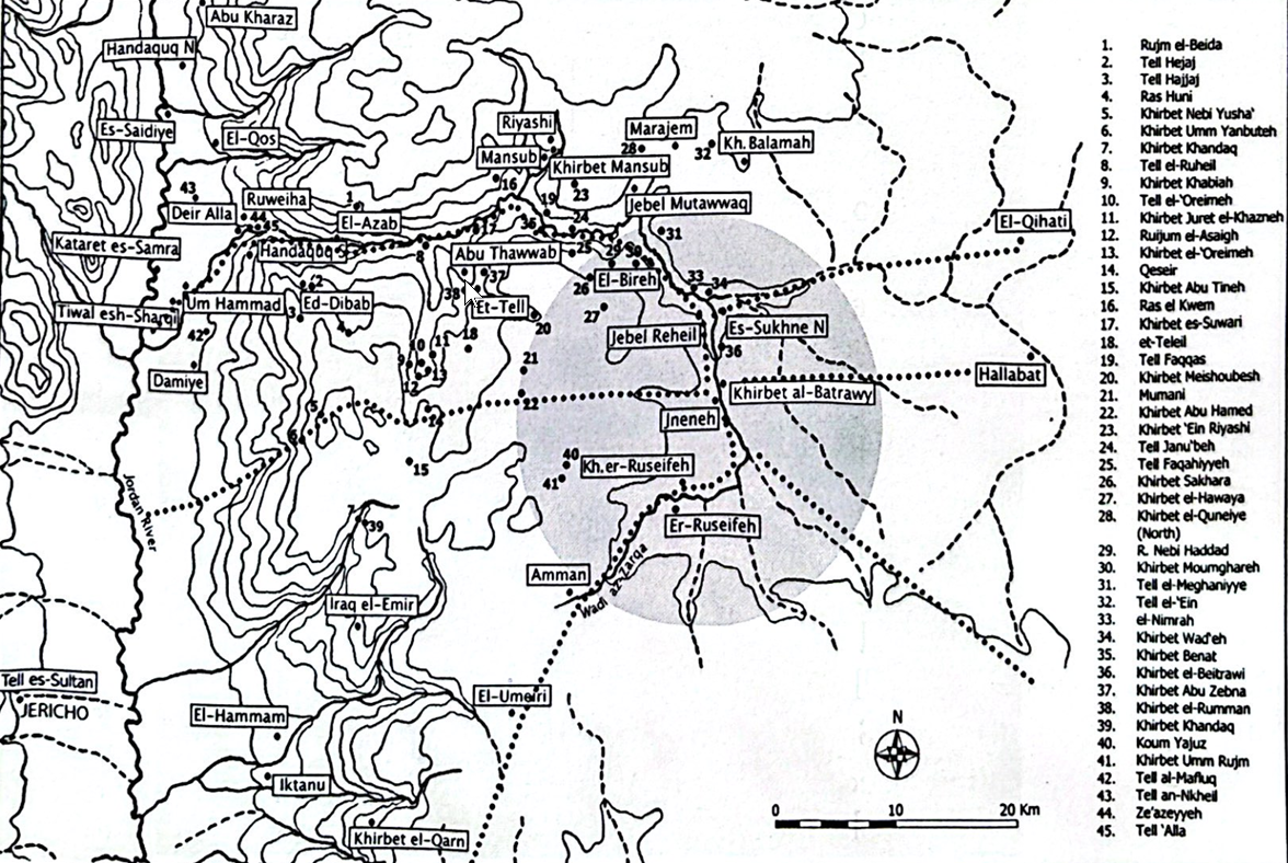 Figure 2
Map of the region of Al Batrawi with the contemporary sites of the area under the city's influence
Image "La Sapienza" Expedition to Jordan
Nigro (2025)
- Khirbet al-Batraway in
OSM from Pleaides
Khirbet al-Batraway location in OSM (Open Street Map)
Pleaides website - Fig. 2 Map of Upper
and Middle Wadi az-Zarqa with visited Early Bronze Age sites, dolmens and archaeological feature from Nigro (2008)
Figure 2.5
Topographical map of Upper and Middle Wadi az-Zarqa with visited Early Bronze Age sites, dolmens and archaeological features detected during 2007 survey.
Nigro (2008) - Fig. 2 Map of region
of Al Batrawi with the contemporary sites from Nigro (2025)
Figure 2
Map of the region of Al Batrawi with the contemporary sites of the area under the city's influence
Image "La Sapienza" Expedition to Jordan
Nigro (2025)
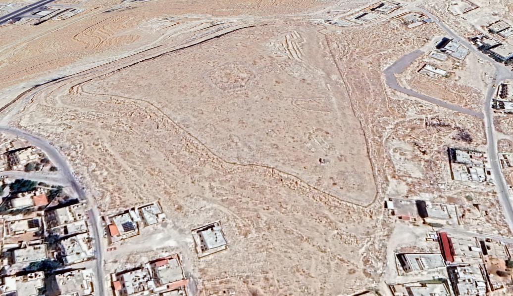
- Fig. 3 Aerial view of
the ancient territory under Batrawy control from Nigro (2008)
 Figure 3
Aerial view of the ancient territory under Batrawy control, inside the big turn towards west of az-Zarqa river.
Nigro (2008) - Khirbet al-Batrawy in Google Earth
 Khirbet al-Batrawy
click on image to explore this site on a new tab in Google Earth
- Fig. 1.2 Topographical
plan of Khirbet al-Batrawy from Nigro (2008)
 Figure 1.2
Topographical plan of Khirbet al-Batrawy (2006-2007).
Nigro (2008)
- Fig. 1.2 Topographical
plan of Khirbet al-Batrawy from Nigro (2008)
Figure 1.2
Topographical plan of Khirbet al-Batrawy (2006-2007).
Nigro (2008)
- Fig. 3.19 EB II city-wall
and gate from Nigro (2008)
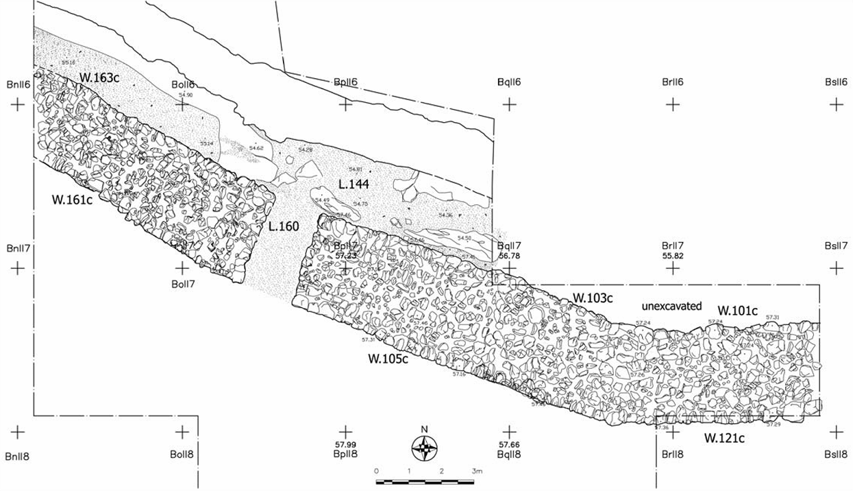 Figure 3.19
Plan of EB II city-wall W.103c+163c + W.104c+ W.105c+W.161c and city-gate L.160.
Nigro (2008) - Fig. 3.23 Schematic
reconstruction of a stretch of Batrawy II city-wall from Nigro (2008)
 Figure 3.23
Schematic reconstruction of a stretch of Batrawy II city-wall.
Nigro (2008)
- Fig. 3.19 EB II city-wall
and gate from Nigro (2008)
Figure 3.19
Plan of EB II city-wall W.103c+163c + W.104c+ W.105c+W.161c and city-gate L.160.
Nigro (2008)
- Fig. 5 Plan of the
South-Eastern Unit of the Eastern Pavilion of the "Palace of the Copper Axes" from Nigro (2025)
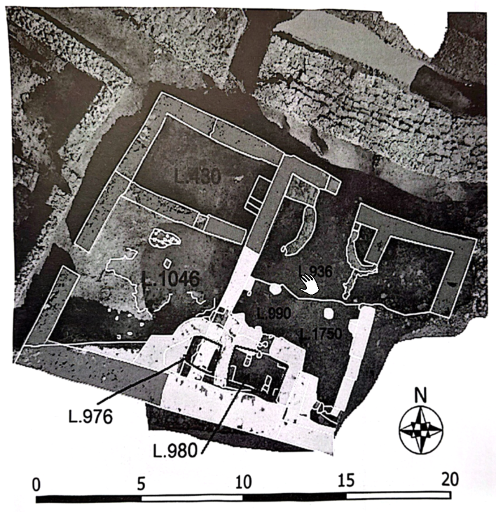 Figure 5
Plan of the South-Eastern Unit of the Eastern Pavilion of the "Palace of the Copper Axes" (light green: original plan of Batrawi IIb; lilac: Batrawi IIIa and IIIb addition of chamber L.976 and room L.980) (image © "La Sapienza" Expedition to Jordan).
Nigro (2025)
- Fig. 5 Plan of the
South-Eastern Unit of the Eastern Pavilion of the "Palace of the Copper Axes" from Nigro (2025)
Figure 5
Plan of the South-Eastern Unit of the Eastern Pavilion of the "Palace of the Copper Axes" (light green: original plan of Batrawi IIb; lilac: Batrawi IIIa and IIIb addition of chamber L.976 and room L.980) (image © "La Sapienza" Expedition to Jordan).
Nigro (2025)
- Fig. 6.10 Plan of
Batrawy II (EB II) city-wall and related floor inside the city from Nigro (2008)
 Figure 6.10
Plan of Batrawy II (EB II) city-wall and related floor inside the city.
Nigro (2008)
- Fig. 6.10 Plan of
Batrawy II (EB II) city-wall and related floor inside the city from Nigro (2008)
Figure 6.10
Plan of Batrawy II (EB II) city-wall and related floor inside the city.
Nigro (2008)
- Fig. 16 Reconstruction
of Temple F1 with its forecourt (Phase 4, Early Bronze II) from Nigro and Sala (2009)
 Figure 16
Reconstruction of Temple F1 with its forecourt (Phase 4, Early Bronze II)
Nigro and Sala (2009)
- Fig. 16 Reconstruction
of Temple F1 with its forecourt (Phase 4, Early Bronze II) from Nigro and Sala (2009)
Figure 16
Reconstruction of Temple F1 with its forecourt (Phase 4, Early Bronze II)
Nigro and Sala (2009)
- Fig. 2.5 Collapsed
stones in Area A West from Nigro (2008)
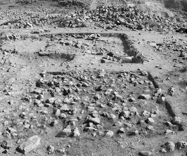 Figure 2.5
Area A West: the layer of collapsed stones F.232 (Activity 3a) in square BjII17, from south; in the background, Cairn II.
Nigro (2008) - Fig. 3.18 EB II-III
fortification walls in Area B North from Nigro (2008)
 Figure 3.18
General view of the EB II-III triple line of fortifications excavated in Area B North, from north: W.103+W.163, the inner and main city-wall; W.155, the Outer Wall; adjoined Scarp-Wall W.165; in the middle, city-gate L.160 was excavated.
Nigro (2008) - Fig. 3.24 Street along
the outer side of Batrawy II city-wall from Nigro (2008)
 Figure 3.24
Street L.144b along the outer side W.103c+W.163c of Batrawy II city-wall, from west.
Nigro (2008) - Fig. 3.37 Earthquake
cracks on eastern jamb of city gate from Nigro (2008)
 Figure 3.37
Earthquake cracks visible on the eastern jamb (W.156) of city gate L.160.
Nigro (2008) - Fig. 3.38 City Gate
after blockage (probable earthquake repair) from Nigro (2008)
 Figure 3.38
City-gate L.160 after the blockage (W.157) at the beginning of the Early Bronze IIIA, from north.
Nigro (2008) - Fig. 3.7 Collapsed stones
in Area B South from Nigro (2008)
 Figure 3.7
General view of layers of collapsed stones F.352 and F.366 (Activity 2a) in squares BpII8 + BpII9, from south-east.
Nigro (2008) - Fig. 7.7 Collapsed stones
in Area F from Nigro (2008)
 Figure 7.7
Area F: layer of collapsed stones F.513 (Activity 2a) excavated in House L.520 in square CpII18, from south-west.
Nigro (2008) - Fig. 15 EB II-III broad
room temple and round platform in Area F from Nigro and Sala (2009)
 Figure 15
General view of the EB II - III broad room temple and round platform S.510 in Area F, from east-southeast.
Nigro and Sala (2009) - Fig. 3 Early Bronze Age
II-III Main Inner Wall (left) and Outer Wall (right) of northern fortifications from Nigro (2025)
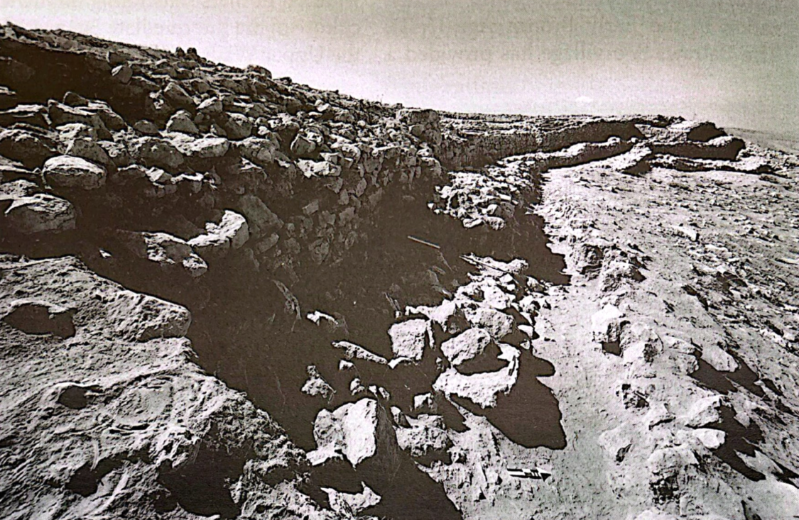 Figure 3
The Early Bronze Age II-III Main Inner Wall (on the left) and Outer Wall (on the right) adjoined in the easternmost stretch of the northern fortifications (2022) (photo © "La Sapienza" Expedition to Jordan
Nigro (2025) - Fig. 4 Early Bronze Age
II-III Main Inner Wall and Outer Wall of northern fortifications from Nigro (2025)
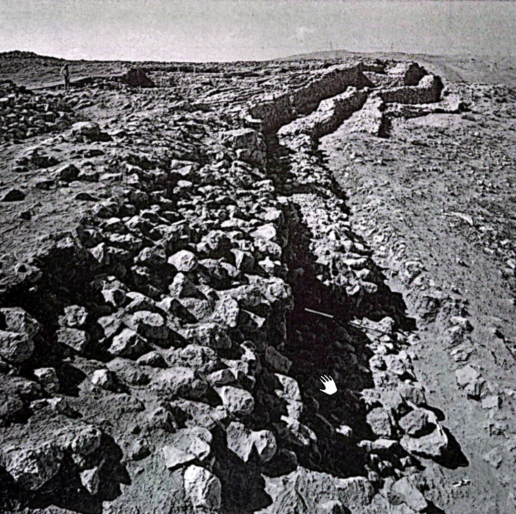 Figure 4
View of the Main Inner Wall and the Outer Wall with the pathway on top of the latter in the easternmost stretch of the northern fortifications; from the north (photo © "La Sapienza" Expedition to Jordan).
Nigro (2025) - Fig. 6 South-Eastern
Unit of the Eastern Pavilion of the "Palace of the Copper Axes" from Nigro (2025)
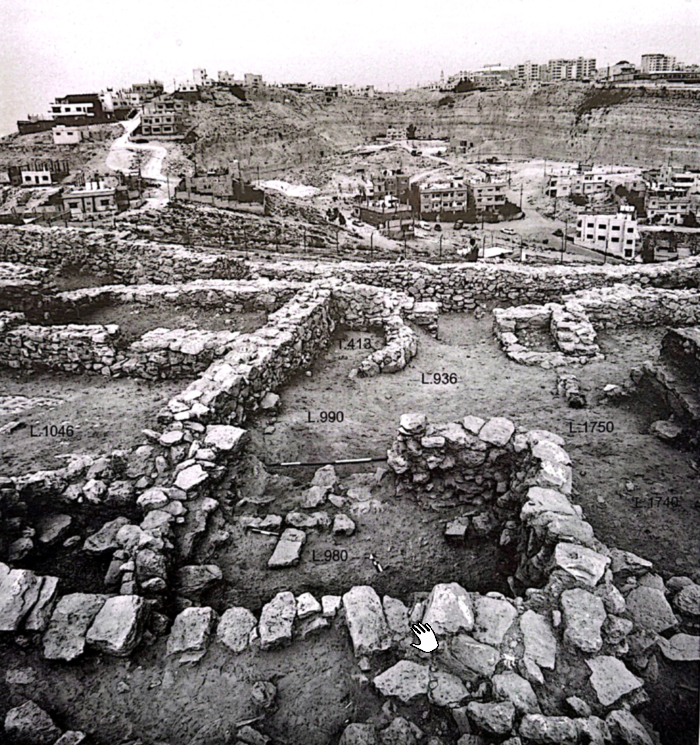 Figure 6
General view of the South-Eastern Unit of the Eastern Pavilion of the "Palace of the Copper Axes" with the added rectangular room L.980; from the south (photo © "La Sapienza" Expedition to Jordan).
Nigro (2025) - Fig. 7 Eastern wall
W.1737 of the South-Eastern Unit of the "Palace of the Copper Axes" from Nigro (2025)
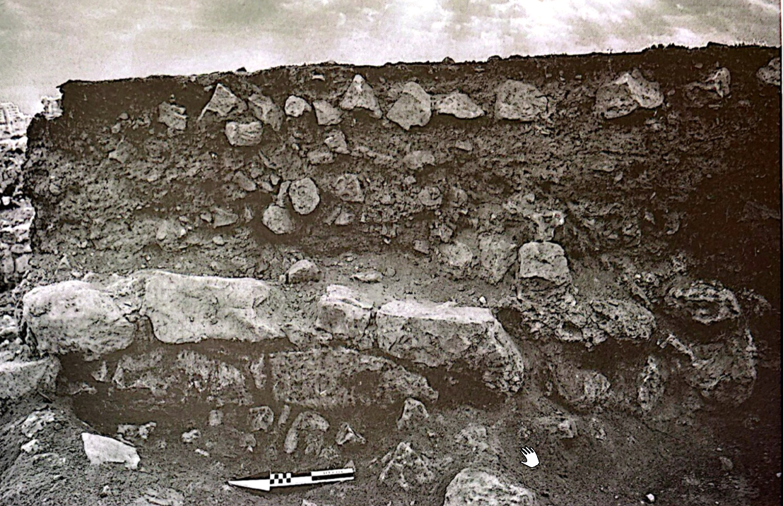 Figure 7
The eastern wall W.1737 of the South-Eastern Unit of the "Palace of the Copper Axes" made of well-cut limestone blocks of the dimensions of regular mud bricks; from the west (photo © "La Sapienza" Expedition to Jordan).
Nigro (2025) - Fig. 8 Aerial view
of the South-Eastern Unit of the "Palace of the Copper Axes" from Nigro (2025)
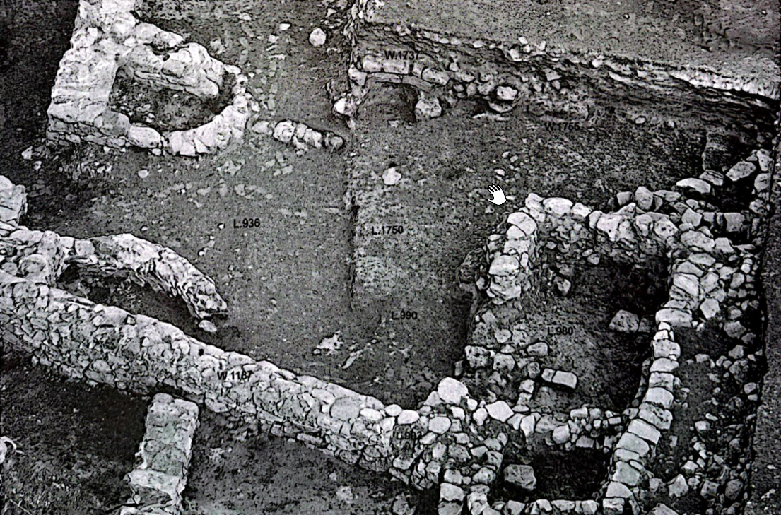 Figure 8
Aerial view of the South-Eastern Unit of the "Palace of the Copper Axes" with the porch L.1750 and the added rooms L.980 and L.976; from the west (photo © "La Sapienza" Expedition to Jordan).
Nigro (2025)
- Fig. 2.5 Collapsed
stones in Area A West from Nigro (2008)
Figure 2.5
Area A West: the layer of collapsed stones F.232 (Activity 3a) in square BjII17, from south; in the background, Cairn II.
Nigro (2008) - Fig. 3.18 EB II-III
fortification walls in Area B North from Nigro (2008)
Figure 3.18
General view of the EB II-III triple line of fortifications excavated in Area B North, from north: W.103+W.163, the inner and main city-wall; W.155, the Outer Wall; adjoined Scarp-Wall W.165; in the middle, city-gate L.160 was excavated.
Nigro (2008) - Fig. 3.24 Street along
the outer side of Batrawy II city-wall from Nigro (2008)
Figure 3.24
Street L.144b along the outer side W.103c+W.163c of Batrawy II city-wall, from west.
Nigro (2008) - Fig. 3.37 Earthquake
cracks on eastern jamb of city gate from Nigro (2008)
Figure 3.37
Earthquake cracks visible on the eastern jamb (W.156) of city gate L.160.
Nigro (2008) - Fig. 3.38 City Gate
after blockage (probable earthquake repair) from Nigro (2008)
Figure 3.38
City-gate L.160 after the blockage (W.157) at the beginning of the Early Bronze IIIA, from north.
Nigro (2008) - Fig. 3.7 Collapsed stones
in Area B South from Nigro (2008)
Figure 3.7
General view of layers of collapsed stones F.352 and F.366 (Activity 2a) in squares BpII8 + BpII9, from south-east.
Nigro (2008) - Fig. 7.7 Collapsed stones
in Area F from Nigro (2008)
Figure 7.7
Area F: layer of collapsed stones F.513 (Activity 2a) excavated in House L.520 in square CpII18, from south-west.
Nigro (2008) - Fig. 15 EB II-III broad
room temple and round platform in Area F from Nigro and Sala (2009)
Figure 15
General view of the EB II - III broad room temple and round platform S.510 in Area F, from east-southeast.
Nigro and Sala (2009) - Fig. 3 Early Bronze Age
II-III Main Inner Wall (left) and Outer Wall (right) of northern fortifications from Nigro (2025)
Figure 3
The Early Bronze Age II-III Main Inner Wall (on the left) and Outer Wall (on the right) adjoined in the easternmost stretch of the northern fortifications (2022) (photo © "La Sapienza" Expedition to Jordan
Nigro (2025) - Fig. 4 Early Bronze Age
II-III Main Inner Wall and Outer Wall of northern fortifications from Nigro (2025)
Figure 4
View of the Main Inner Wall and the Outer Wall with the pathway on top of the latter in the easternmost stretch of the northern fortifications; from the north (photo © "La Sapienza" Expedition to Jordan).
Nigro (2025) - Fig. 6 South-Eastern
Unit of the Eastern Pavilion of the "Palace of the Copper Axes" from Nigro (2025)
Figure 6
General view of the South-Eastern Unit of the Eastern Pavilion of the "Palace of the Copper Axes" with the added rectangular room L.980; from the south (photo © "La Sapienza" Expedition to Jordan).
Nigro (2025) - Fig. 7 Eastern wall
W.1737 of the South-Eastern Unit of the "Palace of the Copper Axes" from Nigro (2025)
Figure 7
The eastern wall W.1737 of the South-Eastern Unit of the "Palace of the Copper Axes" made of well-cut limestone blocks of the dimensions of regular mud bricks; from the west (photo © "La Sapienza" Expedition to Jordan).
Nigro (2025) - Fig. 8 Aerial view
of the South-Eastern Unit of the "Palace of the Copper Axes" from Nigro (2025)
Figure 8
Aerial view of the South-Eastern Unit of the "Palace of the Copper Axes" with the porch L.1750 and the added rooms L.980 and L.976; from the west (photo © "La Sapienza" Expedition to Jordan).
Nigro (2025)
- from Nigro (2025)
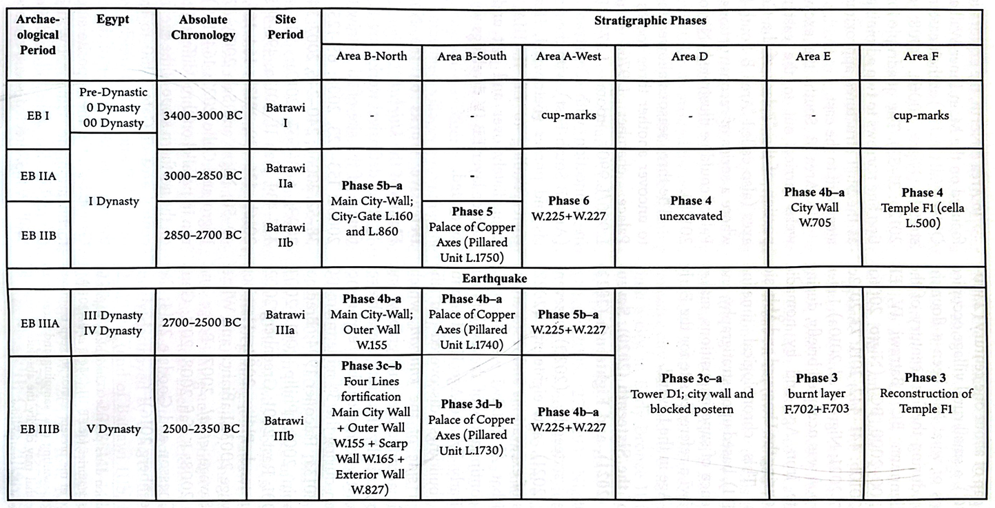
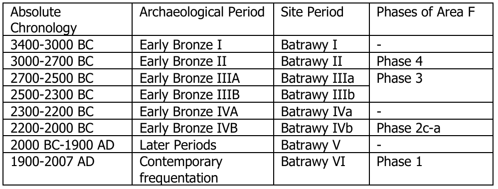
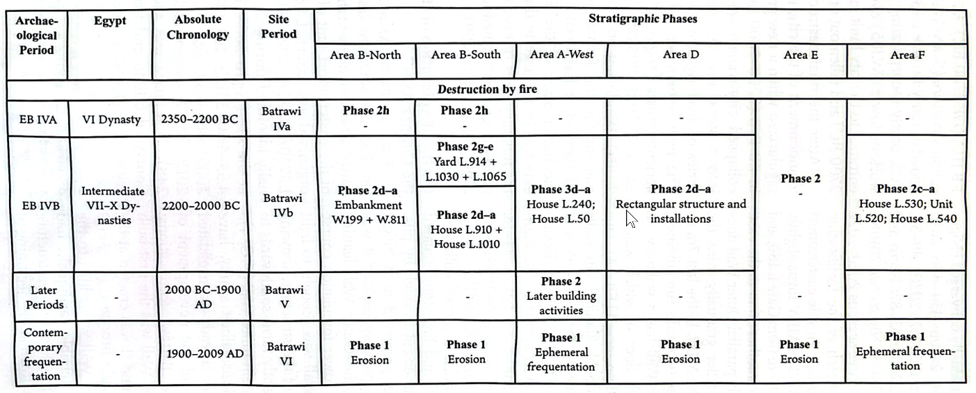 Table 1
Archaeological periodization and stratigraphic phases at Kirbat Al Batrawi
Nigro (2025)
 Table 1
Architectural and stratigraphic phasing of Khirbat al-Batråwi
Nigro and Sala (2010)
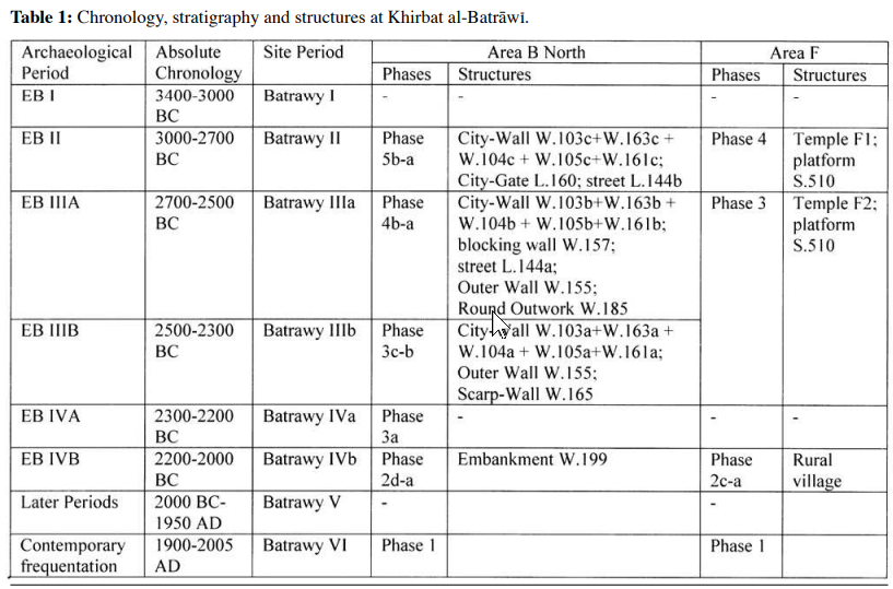 Table 1
Chronology, stratigraphy and structures at Khirbat al-Batråwi
Nigro and Sala (2009)
- from Nigro (2008)
 Table 1.1
Archaeological periodization and stratigraphic phases of Khirbet al-Batrawy.
Nigro (2008)

- from Nigro (2008)
 Table 3.1
Archaeological periodization and stratigraphy of Area B North.
Nigro (2008)
- from Nigro (2008)
 Table 4.1
Archaeological periodization and stratigraphy of Area B South.
Nigro (2008)
- from Nigro (2008:75)
Table 3.1Archaeological periodization and stratigraphy of Area B North.
Nigro (2008)
...
3.1.5. Phase 5: stratigraphy of Batrawy II fortification system
Phase 5 is basically constituted by the destruction layer (Activity 5a) marking the end of the Batrawy II city, and the original constructional phase (Activity 5b).
Activity 5a: destruction of Batrawy II city-gate and city-wall
A layer around 0.2-0.3 m thick preserved only in two spots in the excavated area, namely in square BoII5 (to the west) F.168 (fig. 3.16) and within the gate passage (F.172), including fragmentary grayish mud-bricks and small pebbles, illustrates the collapse and destruction of the city-gate and earliest city-wall of Batrawy II (fig. 3.17).
Activity 5b: construction of Batrawy II city-gate and city-wall
The earliest city-wall and city-gate L.160 were erected directly over the bedrock and included the two doorjambs (W.183 to the east, W.156 to the west), entrance step L.182, marking the passage into the gate, floor L.186 into the passage, and street L.144b outside the gate. All features were linked each other.
- from Nigro (2008:247)
Strata were all eroded according to the slope of the khirbet and they illustrated four main phases (tab. 6.1; fig. 6.4), from the topmost shallowest layer of humus to the earliest strata related to the destruction of Batrawy II city-wall, founded directly upon the bedrock (Phase 4). Structures and finds from destruction layers of Phase 4 will be thoroughly described in § 6.2.
 Table 6.1
Archaeological periodization and stratigraphy of Area E
Nigro (2008)
...
6.1.4. Phase 4: stratigraphy of Batrawy II fortification system
Phase 4 illustrates the erection (Activity 4b), first utilization and sudden end, testified to by a thick collapse layer in the fillings inside the town (Activity 4a), of Batrawy II fortification system during the Early Bronze II.
Activity 4a: destruction of Batrawy II fortification system
Deposits of Period Batrawy II have been clearly identified in the sounding inside the southern line of the main Batrawy city-wall (W.705), where a thick layer of destruction and collapse was accumulated on a floor lying directly over the bedrock. Here, an upper stratum (F.704) of grey clayish sandy soil, 20-25 cm high, with ashy lenses, charcoals and small limestone chops probably from the Batrawy II city-wall superstructure, as well as scattered animal bones (samples KB.06.FR.106 and KB.06.FR.123) and pottery sherds (pl. LIII), covered a greyish layer (F.706), 20 cm thick, basically composed of compacted charcoals, ash and crushed greyish mud bricks, with numerous limestone grits, chops and mud mortar from the EB II city-wall collapsed superstructure (§ 6.2.), as well as a few pottery sherds (pl. LIV). Both these layers sloped from north to south and from west to east according to the natural slope of the bedrock.
Activity 4b: erection of Batrawy II fortification system
Activity 4b represents the erection of Batrawy II city-wall, the earliest phase of the Batrawy fortification system, similarly detected in Area B North (§ 3.1.4.). It is illustrated by the inner face of city-wall W.705 and the earliest floor exposed inside the town (L.710), lying directly upon the bedrock, in trench CdIII9 + CeIII9 (§ 6.2.), and by the inner face of the westerner juxtaposed stretch of city-wall W.707, further to the west.
| Effect | Location | Image(s) | Description |
|---|---|---|---|
|
Area B North (north city-wall)
Figure 3.19 Plan of EB II city-wall W.103c+163c + W.104c+ W.105c+W.161c and city-gate L.160. Nigro (2008)
Figure 3.23Schematic reconstruction of a stretch of Batrawy II city-wall. Nigro (2008)
Figure 1.2Topographical plan of Khirbet al-Batrawy (2006-2007). Nigro (2008) |
Figure 3.37 Earthquake cracks visible on the eastern jamb (W.156) of city gate L.160. Nigro (2008)
Figure 3.38City-gate L.160 after the blockage (W.157) at the beginning of the Early Bronze IIIA, from north. Nigro (2008) |
|
|
Area B North (north city-wall)
Figure 3.19 Plan of EB II city-wall W.103c+163c + W.104c+ W.105c+W.161c and city-gate L.160. Nigro (2008)
Figure 3.23Schematic reconstruction of a stretch of Batrawy II city-wall. Nigro (2008)
Figure 1.2Topographical plan of Khirbet al-Batrawy (2006-2007). Nigro (2008) |
Figure 3.24 Street L.144b along the outer side W.103c+W.163c of Batrawy II city-wall, from west. Nigro (2008) |
|
|
Area E (south city-wall)
Figure 6.10 Plan of Batrawy II (EB II) city-wall and related floor inside the city. Nigro (2008)
Figure 3.23Schematic reconstruction of a stretch of Batrawy II city-wall. Nigro (2008)
Figure 1.2Topographical plan of Khirbet al-Batrawy (2006-2007). Nigro (2008) |
|
|
|
Area F - Early Bronze IIB
Broad Room Temple F1
Figure 15 General view of the EB II - III broad room temple and round platform S.510 in Area F, from east-southeast. Nigro and Sala (2009)
Figure 16Reconstruction of Temple F1 with its forecourt (Phase 4, Early Bronze II) Nigro and Sala (2009)
Figure 1.2Topographical plan of Khirbet al-Batrawy (2006-2007). Nigro (2008) |
|
|
|
Eastern Pavillion in Area B South also known as the Palace of the Copper Axes (Pillared Unit L.1750)
Figure 1.2 Topographical plan of Khirbet al-Batrawy (2006-2007). Nigro (2008)
Figure 5Plan of the South-Eastern Unit of the Eastern Pavilion of the "Palace of the Copper Axes" (light green: original plan of Batrawi IIb; lilac: Batrawi IIIa and IIIb addition of chamber L.976 and room L.980) (image © "La Sapienza" Expedition to Jordan). Nigro (2025) |
Figure 8 Aerial view of the South-Eastern Unit of the "Palace of the Copper Axes" with the porch L.1750 and the added rooms L.980 and L.976; from the west (photo © "La Sapienza" Expedition to Jordan). Nigro (2025)
Figure 7The eastern wall W.1737 of the South-Eastern Unit of the "Palace of the Copper Axes" made of well-cut limestone blocks of the dimensions of regular mud bricks; from the west (photo © "La Sapienza" Expedition to Jordan). Nigro (2025)
Figure 6General view of the South-Eastern Unit of the Eastern Pavilion of the "Palace of the Copper Axes" with the added rectangular room L.980; from the south (photo © "La Sapienza" Expedition to Jordan). Nigro (2025) |
|
- Modified by JW from Fig. 1.2 from Nigro (2008)
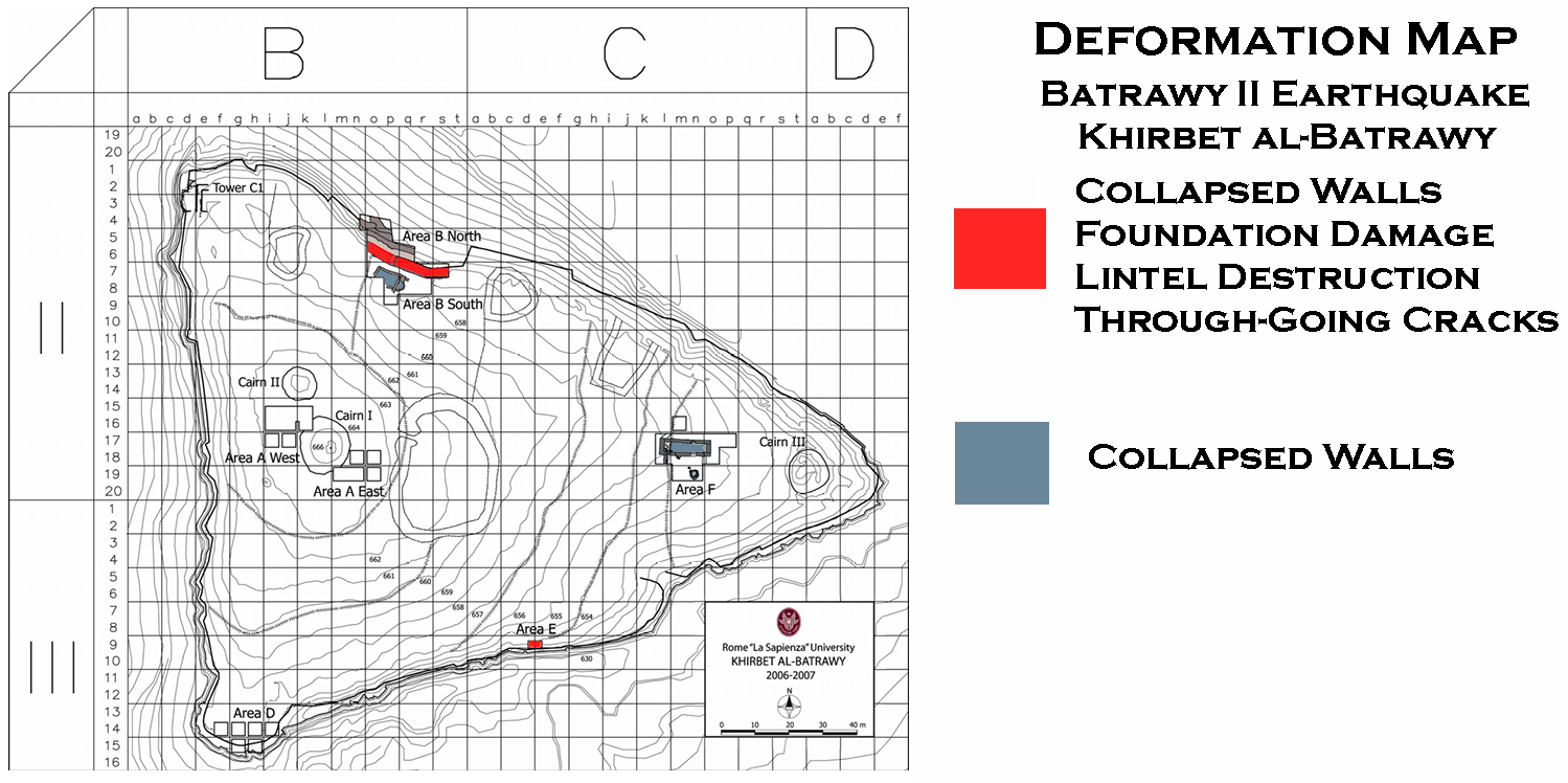 Deformation Map
Modified by JW from Fig. 1.2 from from Nigro (2008)
-
Earthquake Archeological Effects chart
of Rodríguez-Pascua et al (2013: 221-224)
 Earthquake Archeological Effects (EAE)
Rodríguez-Pascua et al (2013: 221-224)
| Effect | Location | Image(s) | Description | Intensity |
|---|---|---|---|---|
|
Area B North (north city-wall)
Figure 3.19 Plan of EB II city-wall W.103c+163c + W.104c+ W.105c+W.161c and city-gate L.160. Nigro (2008)
Figure 3.23Schematic reconstruction of a stretch of Batrawy II city-wall. Nigro (2008)
Figure 1.2Topographical plan of Khirbet al-Batrawy (2006-2007). Nigro (2008) |
Figure 3.37 Earthquake cracks visible on the eastern jamb (W.156) of city gate L.160. Nigro (2008)
Figure 3.38City-gate L.160 after the blockage (W.157) at the beginning of the Early Bronze IIIA, from north. Nigro (2008) |
|
|
|
Area B North (north city-wall)
Figure 3.19 Plan of EB II city-wall W.103c+163c + W.104c+ W.105c+W.161c and city-gate L.160. Nigro (2008)
Figure 3.23Schematic reconstruction of a stretch of Batrawy II city-wall. Nigro (2008)
Figure 1.2Topographical plan of Khirbet al-Batrawy (2006-2007). Nigro (2008) |
Figure 3.24 Street L.144b along the outer side W.103c+W.163c of Batrawy II city-wall, from west. Nigro (2008) |
|
|
|
Area E (south city-wall)
Figure 6.10 Plan of Batrawy II (EB II) city-wall and related floor inside the city. Nigro (2008)
Figure 3.23Schematic reconstruction of a stretch of Batrawy II city-wall. Nigro (2008)
Figure 1.2Topographical plan of Khirbet al-Batrawy (2006-2007). Nigro (2008) |
|
|
|
|
Area F - Early Bronze IIB
Broad Room Temple F1
Figure 15 General view of the EB II - III broad room temple and round platform S.510 in Area F, from east-southeast. Nigro and Sala (2009)
Figure 16Reconstruction of Temple F1 with its forecourt (Phase 4, Early Bronze II) Nigro and Sala (2009)
Figure 1.2Topographical plan of Khirbet al-Batrawy (2006-2007). Nigro (2008) |
|
|
|
|
Eastern Pavillion in Area B South also known as the Palace of the Copper Axes (Pillared Unit L.1750)
Figure 1.2 Topographical plan of Khirbet al-Batrawy (2006-2007). Nigro (2008)
Figure 5Plan of the South-Eastern Unit of the Eastern Pavilion of the "Palace of the Copper Axes" (light green: original plan of Batrawi IIb; lilac: Batrawi IIIa and IIIb addition of chamber L.976 and room L.980) (image © "La Sapienza" Expedition to Jordan). Nigro (2025) |
Figure 8 Aerial view of the South-Eastern Unit of the "Palace of the Copper Axes" with the porch L.1750 and the added rooms L.980 and L.976; from the west (photo © "La Sapienza" Expedition to Jordan). Nigro (2025)
Figure 7The eastern wall W.1737 of the South-Eastern Unit of the "Palace of the Copper Axes" made of well-cut limestone blocks of the dimensions of regular mud bricks; from the west (photo © "La Sapienza" Expedition to Jordan). Nigro (2025)
Figure 6General view of the South-Eastern Unit of the Eastern Pavilion of the "Palace of the Copper Axes" with the added rectangular room L.980; from the south (photo © "La Sapienza" Expedition to Jordan). Nigro (2025) |
|
|