Khirbet Ader
 Vicinity of Khirbet Ader
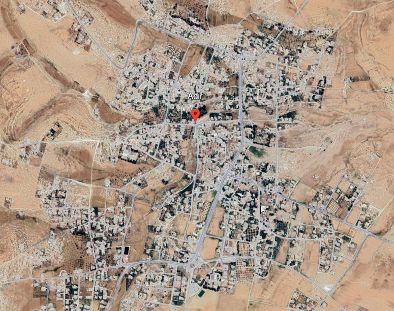
click on image to explore this site on a new tab in Google Earth
| Transliterated Name | Language | Name |
|---|---|---|
| Ader | an old Northwest-Semitic language, perhaps Ugaritic | |
| Khirbet Ader | Arabic | |
| Adir | Arabic | |
| Adara | Greek ? | |
| Oddr in Karrak | German | |
| Addar | English | |
| Addir | German |
- from Chat GPT 5 Thinking, 8 November 2025
- sources: Cleveland (1954)
Archaeologically, Khirbet Ader is distinguished by its Early Bronze Age monumental remains: a cluster of standing stones (menhirs/massibot) and the foundations of a major sanctuary complex set within an extensive settlement that in its floruit covered on the order of ten acres, far surpassing the later Byzantine occupation in extent. Surface exploration and the 1933 soundings confirmed intensive Early Bronze activity together with later Roman–Nabataean and Byzantine traces, but also documented heavy stone-robbing and the encroachment of the modern village across much of the tell.
Khirbet Ader thus emerges as a key highland sanctuary and settlement on the Kerak plateau, combining a prominent ritual focus marked by menhirs with a substantial Early Bronze urban footprint and later classical-period reuse, while its modern disturbance underscores the urgency of Cleveland’s concise 1933 soundings as a primary record of the site.
- Vicinity of Khirbet Ader
in Google Earth
Vicinity of Khirbet Ader
click on image to explore this site on a new tab in Google Earth
- Pl. 20A Roman Period
burial inside northwest corner of city-wall from Cleveland (1954:84-87)
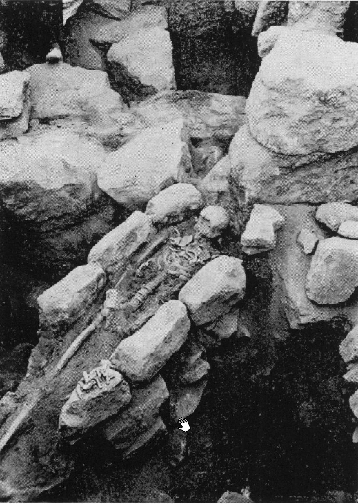 Plate 20 A
Roman Period burial inside northwest corner of city-wall, from west
click on image to open in a new tab
Cleveland (1954)
- Pl. 20A Roman Period
burial inside northwest corner of city-wall from Cleveland (1954:84-87)
Plate 20 A
Roman Period burial inside northwest corner of city-wall, from west
click on image to open in a new tab
Cleveland (1954)
Inasmuch as the principal purpose of the expedition to Ader was to excavate the ruins of the temple discovered in 1924, it was a great disappointment for the staff to discover, when it arrived at the site, that the building boom in Ader had resulted in the almost complete destruction of the temple foundations. The stone had been carried off for new houses, and in fact a house now occupied at least part of the site of the temple. The section of wall excavated in the courtyard of this house was thought to belong to the temple, but this is not certain. Although the main objective of the expedition was thus frustrated, there was still much to learn about the occupational history of the site. Land claims were taken care of, mostly by Mr. Head, and it was possible to make soundings at almost any desirable point on the tell which was not occupied4.
Actual digging began on Monday, November 13, at the northwest corner of the wall which encompasses the main tell. Trenches were begun both inside and outside of the north wall at this point. The original labor force was limited to 22 men. Most of the pottery sherds found during the first day were from the Arab period, although a few sherds from Hellenistic-Roman and Byzantine times were also uncovered. The city wall was discovered to be 2.2 meters wide along the north side, in contrast to a width of 1.6 meters for the west wall.
Four days' work was expended on the corner of the city wall. During the second day's work, a fairly well preserved room, containing exclusively Roman pottery of about the third century, was disclosed just inside the northwest corner of the city. Two walls of this room were formed by the city walls themselves, which is conclusive evidence that the city wall was built before the Byzantine Period. A mass of stone had fallen from the south into the room. Among these stones—all above the pavement of the room—was a Hebrew inscription, probably from the Byzantine Period. Human bones, including a skull, were just below the inscribed stone. About two meters from these first bones were found more bones, which were discovered to be from a cist burial. This slipper-shaped cist burial contained the bones of a man 1.65 m. in height.
The following morning Mr. Head cleared out the tomb. He found that it had already been robbed, but potsherds provided sufficient evidence to date it. Among the potsherds were pieces of an almost complete Roman bowl of rouletted terra sigillata, three painted Nabataean potsherds, and half of a Roman lamp. The tomb was covered by the floor of the later room, which dated to the third century A. D., so the burial belongs to the second or early third century. A large slab remained in place over the east end of the burial. The tomb, the room, and the city walls were carefully planned and their levels taken (reproduced in Fig. 10).
Besides the area at the northwest corner of the city wall, the only significant sounding made elsewhere on the main tell was at a tower which stood outside the north wall of the city some distance east of the corner described above. Two days, November 20 and 21 (Monday and Tuesday) were spent clearing this tower, which was discovered to have two phases, a late Roman and a Byzantine. Both the late Roman and Byzantine Periods were represented by sherds found inside the tower. The Roman phase was apparently represented in the structural remains by one course of masonry on the north and west; the west part of this course meets the city wall at a right angle. The later phase is represented by a second course of stone, which coincides vertically with the first course on the eastern part of the north wall of the tower. Toward the west it diverges, so that at the northwest corner of the tower it has a set-back of some 15 cm. from the outside face of the lower course. On the west side of the tower the set-back is between 20 and 25 cm. The second course meets the city wall at an acute angle. At all points the line between the two courses is clear.
On the inside of the tower, a very crude rubble wall 75 cm. high was found resting on bedrock. Above on the north and south was a fine facing wall of dressed Roman masonry (the facing on the south can be seen in the photograph, Plate 20:D).
The height of the first course at the northeast corner of the tower was 50 cm. The height of the second course was not recorded. The north face of the tower in the middle was 1.6 m. above bedrock. The outer face of the main city wall in the center of the tower was preserved to 1.75 m. above the bottom casing.
The area investigated which proved to be of the greatest significance stratigraphically at Ader was a trench 4 m. by 10 m. (with the greatest length running east-west) excavated on the low mound to the north of the city. This trench was dug under the supervision of Dr. Gordon during the four days November 15 to 18. The archaeological records of the area were made by Dr. Albright. Because of land claims, Christian Arab peasants had to be employed as workmen within the city, and in the excavations outside the walls, it was necessary to use beclu (Bedouin) who were so totally unaccustomed to manual labor that in the time available it proved impossible to get them to work efficiently or to follow instructions. As a result, the records of the soundings on the Early Bronze mound suffered greatly.
During the first day's work in the 4 m. by 10 m. trench, fifteen nomad workmen dug down to an average depth of 80 cm. below the surface of the ground, finding a considerable amount of early Middle Bronze Age pottery and uncovering the corner of a house. The walls of the house ran at an angle of about 45° to the sides of the trench, with the inside of the house in the western part of the trench. The outer corner of the house was about 3.7 m. from the west end of the trench. The two walls were about cm. wide and had one course of rocks for foundations, above which there appeared to be traces of mud bricks. The top of the walls were approximately 70 cm. below the surface of the ground. A thick layer of burning covered the area inside the walls ; all the debris above this layer of ash was designated as Phase A. The burned layer was also found on the east of the walls, where it was between 95 cm. and 1.1 m. below the surface, except at the eastern end of the trench, where it dropped away with the talus.
The second day's work in the trench took the excavations below the walls of the house into an earlier level, designated Phase B. This level, which was a little less than 1.5 m. thick, was full of fallen adobe brick with interspersed layers of ash. No more of the rims exemplified by Fig. 13:4 were found in this level, nor were true ledge-handles found during the second day. Work was resumed the third day at an average depth of 1.6 m. below the surface. Older pottery styles were found, including wavy ledge-handles. During the morning a mud-brick wall with one course of bricks was uncovered. It had a thick coat of plaster and a foundation of small stones. A large quantity of ash was found at one point along the south side of the trench.
In the fourth and last day spent in this trench, undisturbed yellow clay was reached at an average depth of 2.7 m. The lowest level, Phase C, was very thin and contained solely Early Bronze Age sherds, including rims of the type represented by Fig. 14:12, as well as wavy ledge-handles. The total period represented in the trench was estimated at perhaps three centuries, running from about the 22nd to the 19th century B.C.
At least one day, Monday, November 20, was spent digging what was thought to be the south wall of the nearly destroyed temple or sanctuary on the northwest slope of the smaller tell. This operation had of necessity to be carried out in the courtyard of Mohammed `Odetallah's house. Nothing of much significance, unfortunately, was found to aid in the reconstruction of the temple plan—assuming this wall belonged to it—or to help in dating the structure.
The last three days of the archaeological work at Ader were mostly devoted to a shallow pit on the small tell. The director's attention had been called to this unlikely spot by the helpful Bedouin Mohammed `Odetallah, who asserted that he and others had seen a long flame of fire shoot from the pit like a flash of lightning on more than one occasion5. The pit proved to be a vertical shaft three meters square providing access to a cave which had been used as a group-tomb. Part of the rock forming the cave roof above the doorway had fallen in, but with its removal, entrance to the cave became possible. Considerable quantities of Early Bronze Age pottery, all belonging to Phase C of the large trench, were found in the bottom of the vertical shaft. A smaller quantity of sherds had seeped into the cave from the broken roof. The tomb was clearly used for burial in the Early Bronze Age. Several flint knives were also among the debris at the bottom of the tomb shaft.
3 Cyrus Gordon, Adventures in the Nearest East (Fair Lawn, N. J., 1957), p. 30; Bulletin 53, p. 14.
4 Ibid.
5 6 For the full account of an amusing incident connected with the clearing of the " pit " see Gordon's
Adventures in the Nearest East, pp. 31-34. [This book is a revised and enlarged form of Gordon's earlier book,
The Living Past (London, 1941), which also has the story.]
In Stratum 11, additions were made to the Roman structure (temple) on the acropolis and a magnificent stairway of monumental size replaced the Stratum 13-12 ramp as the south access route to the acropolis complex. At the foot of the stairway, an even more extensive plaza was laid, which covered that part of Room 3 (in Square D.3) not covered by the stairway. On the western slope of the tell, continued use of earlier buildings and walls is demonstrated by the accumulation of floors and soil layers over Stratum 12 remains.
The date for the beginning of Stratum 11 is somewhat arbitrary. The latest coin in Stratum 12 loci is one probably issued under Elagabalus (B.1:13; Object No. 2104) which would place it around A.D. 222 at latest, with the stratum closing out at some time after that. Since there is no clear stratigraphic break across the tell, the date of A.D. 284 was selected with respect to the beginning of the reign of Diocletian who began a reorganization of the empire of major proportions.
Though the beginning date for the stratum is somewhat uncertain (and stratigraphic horizon is somewhat arbitrary), the end of it seems fixed quite well. A destruction of some sort tumbled the wall on the east side of the great stairway, signaling the end of the stairway's use. This destruction has been interpreted to have been caused by the earthquake of A.D. 363 (possibly A.D. 365) which wreaked much havoc at Kerak, about 70 km south of Esbus (Kallner-Amiran 1951: 225; Russell 1980a). This event also apparently destroyed the temple on the acropolis, which was never rebuilt as a temple.
Field techniques (including the records kept) in some squares and seasons in Area A have sometimes made it difficult to decide the assignation of particular archaeological remains. Though this is troublesome, expressly where the Byzantine and Late Roman materials meet (Strata 10/11), J. Bjornar Storfjell (who prepared Strata 10-5 for final publication) and I worked out the important sequences which appear in these final reports. The reconstruction we present is reasonably satisfactory and quite defensible, though it does differ somewhat from the preliminary reports.
The primary evidence for Stratum 11 comes from Area A Squares A.1 through A.6; Area D Squares D.2, D.3, and D.4; Area B Squares B.1, B.2, B.3, and B.4; and Area C Squares C.5, C.7, and C.10 (fig. 6.1).
Evidence from the foot of the monumental stairway is clear regarding the nature of the Stratum 11 destruction. In the drawing of the balk separating Squares D.3 and D.4 (Square D.3 south balk section, fig. 6.4 and pl. 6.13, and Square D.4 north balk section, fig. 6.5 and pl. 6.14), is visible a massive tumble (D.3:84 [= D.4:34], D.4:36, and D.4:53) spilled westward over the uppermost huwwar layers south of the stairs (pl. 6.15). The source of this material was most probably the retaining wall at the east margin of the stairs (D.3:16A).
The evidence is interpreted as being the result of the same earthquake which greatly damaged Kerak. The numismatic evidence supports this later closing date for the stratum. From locus C.5:219, an Early Byzantine soil layer, a coin of Constans I, A.D. 343 (Object No. 2940) was recovered (pl. 6.16). Unfortunately no coins were found in the latest huwwar layers south of the monumental stairway laid down before the earthquake. By the definition of a stratum adopted by the authors of the final period reports (Andrews University Heshbon Expedi- tion 1977:1), I have deemed it unnecessary to retain the separation of the three preliminary Early Byzantine strata (XII–XIV). Furthermore, these preliminary strata represent primarily, if not almost entirely, a rather localized phenomenon. Interestingly enough, another coin of Constans I also dated A.D. 343 (Object No. 1076) was recovered from an Area A locus assigned to Stratum 10 (locus A.5:23), thus effectively bracketing the stratigraphic break in the archaeological remains on the tell. An Ayyubid coin (Object No. 0546) from a questionable Stratum 11 locus (A.2:23) comes from a mixed context. Though the loci above locus A.2:23 are not Ayyubid/Mamluk, it appears likely that the integrity of the locus cannot be assumed. (For a more comprehensive treatment of numismatics at Tell Hesban, see volume 12 of this series.)
No other clear evidence for Stratum 11 destruction occurs on the site, with the exception of the cistern in Square C.5 (C.5:228) which was put out of use at the end of this period. For Area A, the assumption is that building activity (including earth-moving and stone-robbing) effectively obliterated Stage A evidence. In Area C, later Islamic building activity most probably is responsible for the lack of such evidence.
In terms of parallels, there is quite clear evidence for a pre-earth- quake Early Byzantine occupation at ʿAraq el-Emir, less than 15 km north and east of Esbus. About 0.5 m of fill covered the first (lowest) Byzan- tine floor surface. An oven installed in the surface of the fill indicates continued occupation. This fill layer was then covered by earthquake tumble in the A.D. 365 seismic event (Lapp’s date; 1962: 84).
In the publication of excavation results of Khirbet Ader (7 km north- east of Kerak), a similar picture is reported, with debris covering a floor, beneath which there were found “second or early third century” sherds (Cleveland 1960: 84-85 and pl. 20). At Avdat, in the Negev, retaining walls were shattered and had been rebuilt by Byzantine masons (Negev 1961: 126). And finally, from Jerash, there are reports of a stair reconstructed perhaps as a result of its destruction, most likely in A.D. 362 or 365 (according to J. W. Crowfoot; 1931: 144).
Kenneth W. Russell argues for a date of May 19, A.D. 363 for the earth- quake responsible for widespread destruction in Palestine (1980a: 47-64). He uses a letter of Cyril (published recently by S. P. Brock) to correct the date given in D. H. Kallner-Amiran’s widely-quoted earthquake catalogue (1951, 1952). Numismatic evidence which Russell provides from the destruction level of a house in Petra generally parallels that from Stratum 11 at Tell Hesban (1980a: 48-49).
Actually, the crucial problem that concerns our site is not whether an ex- tensive earthquake in Palestine is to be dated A.D. 363 or 365. The issue is where in the stratigraphy of Tell Hesban Areas B and D to locate this destructive earthquake. In his preliminary report on the 1971 season, Sauer identified this earthquake with his Stratum 6 (1973a: 48) and reiterated that position in his 1973 report (1975: 142-143). I have been unable to locate in the 1971 report the specific assignation of particular loci to Stratum 6. From Sauer’s statement that “a 365/366 coin would suggest that the rock tumble and bricky red soil of Stratum 6 should be associated with a 365 earthquake” I would judge that the locus in question (among others, if there are any) is locus B.1:4 (containing the coin in question: Object No. 0115). If locus B.1:4 is the correct one, a “Stratum 6” date in the fourth century A.D. for this locus appears untenable: locus B.1:4 also produced a coin of Valentinian II (A.D. 375-392) and a Mamluk coin (A.D. 1453-1461) along with Arabic pottery (15 pails out of 15) and modern pottery (5 out of 15 pails). J. Bjornar Storfjell (personal communication, April 1980) was prepared to argue that Square B.1 was not necessarily dug poorly, rather that, by and large, the evidence of late material in B.1:4 must be taken seriously. (Interestingly enough, the locus is taken seriously enough by Sauer for him to accept the validity of the A.D. 365/366 coin.)
In my opinion, the ceramic evidence, for example in Squares D.3/D.4, is against moving the damage of the A.D. 363 earthquake upward well over 1 m through several soil layers. Sauer’s extensive Area B section drawing (last updated following the 1973 season), in comparison with the present north balk section of Square D.4, makes my point sufficiently well: Surface D.4:35 (= D.4:56 [= D.3:40 = B.3:26 = B.7:26]) in all probability forms the last surface to serve the Late Roman monumental stairway. Of these loci, 20 pottery pails were read, resulting in one Early Byzantine ceramic call (in locus B.7:26) and one Early Byzantine sherd (in locus D.3:40). The following, i.e. next highest, loci (D.3:38, D.4:34 [= D.4:53], B.7:25, and B.3:25) appear to present a changing ceramic picture: 21 pails read, with 7 Early Byzantine ceramic calls (in loci D.3:38, B.7:25, and B.3:25). I believe the interface between Late Roman and Early Byzantine ceramics, dated by Sauer to A.D. 324 (Table 1.2), is to be found at, or stratigraphically very near, the interface of these two sets of loci. Of course this conclusion is based on field pottery readings and the accepted dates for Late Roman/Early Byzantine, but it seems reasonable to locate the A.D. 363 (possible A.D. 365) earthquake as Storfjell and I have, with tumble loci D.3:84 [= D.4:34] and related debris.
Loci which are assigned to Stratum 11, but to no specific stage assignment include: A.2:24; C.2:29; C.5:226; C.7:66, C.7:80, C.7:86, C.7:101; C.10:32, C.10:33, C.10:35-39, C.10:56, and C.10.61.
| Effects | Location | Image(s) | Description |
|---|---|---|---|
|
Room just inside NW City Wall |
|
-
Earthquake Archeological Effects chart
of Rodríguez-Pascua et al (2013: 221-224)
 Earthquake Archeological Effects (EAE)
Rodríguez-Pascua et al (2013: 221-224)
| Effects | Location | Image(s) | Description | Intensity |
|---|---|---|---|---|
|
Room just inside NW City Wall |
|
|
Bieniada, Michal E. (2016) Intermediate Bronze Age In Southern Levant (4200–4000 Bp)– Why Did Four Cities In Transjordan Survive Urban Collapse?
Cleveland, R. L. (1954). The Excavation of the Conway High Place (Petra) and Soundings at Khirbet Ader
. The Annual of the American Schools of Oriental Research, 34/35, 53–97.
Herr, Larry G. (2010) Ader, Khirbet
, in Encyclopedia of the bible and its reception
- download these files into Google Earth on your phone, tablet, or computer
- Google Earth download page
| kmz | Description | Reference |
|---|---|---|
| Right Click to download | Master kmz file | various |