Tell Es-Sultan (Jericho)
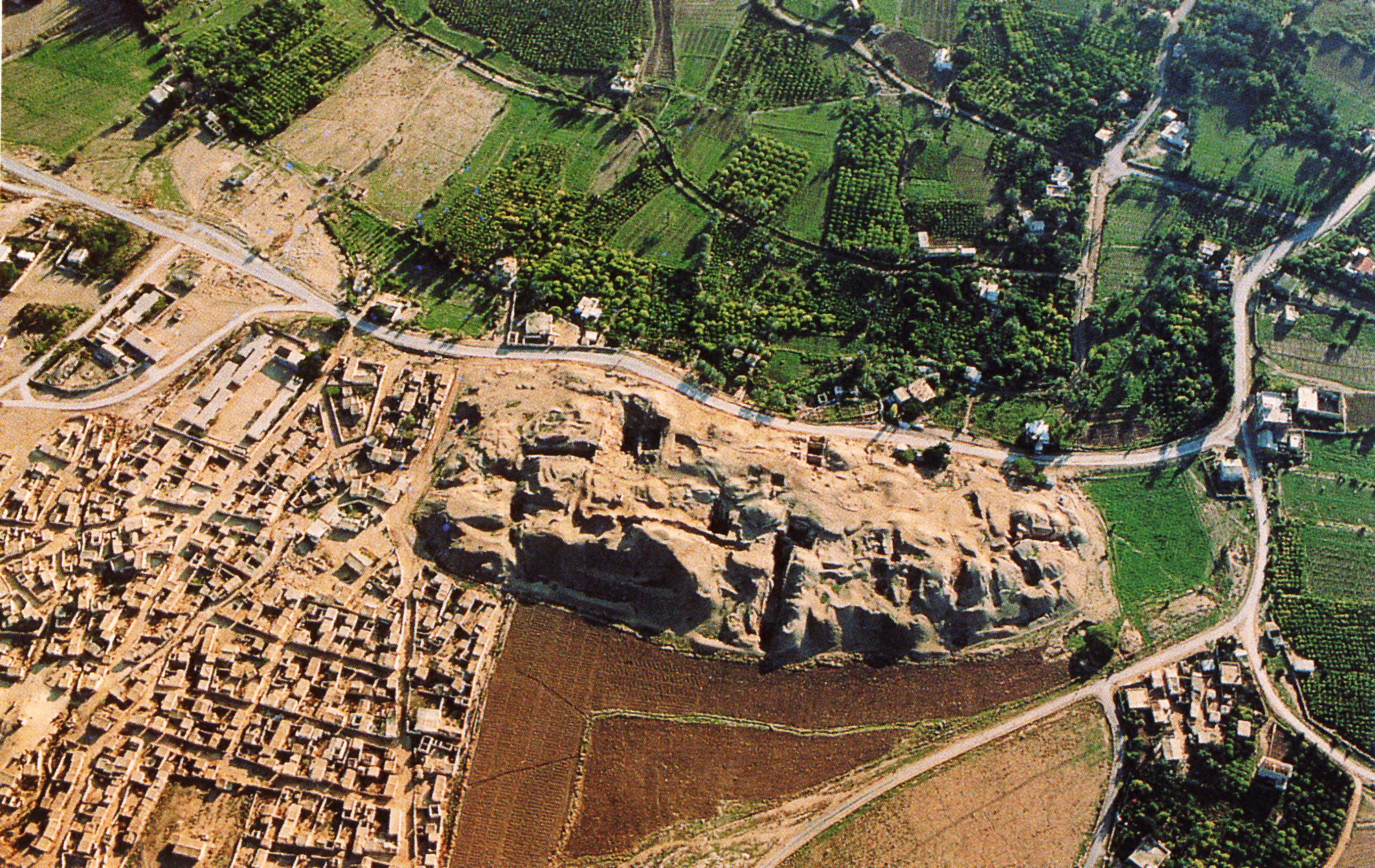 Aerial view of Tell Es-Sultan
click on image to open a higher resolution magnifiable image in a new tab
Fullo88 - Italian Wikipedia - Public Domain
| Transliterated Name | Source | Name |
|---|---|---|
| Tel Jericho | English | |
| Ancient Jericho | English | |
| Tell es-Sultan | Arabic | تل السلطان |
- Fig. 5 Geological sketch
of the Tell es-Sultan and surrounding area from Alfonsi et al. (2012)
 Figure 5
Geological sketch of the Tell es-Sultan surrounding area. Fault traces (Roth, 1970; Begin, 1974; Shamir et al., 2005; Shamir, 2006) and the location of Tell and other major sites of great cultural interest are reported. Photos:
- fault zone in a Cretaceous deposit northeast of the Tell
- view from the southeast of a northeast—southwest-trending scarp (red arrows point the crest) along the Nuweime fault trace. Tell es-Sultan is in the background
Alfonsi et al. (2012) - Location Map from
Stern et. al. (1993 v.2)
 Map of the main sites at Jericho and its environs, Roman-Byzantine period.
Stern et. al. (1993 v.2) - Fig. 1 - Location Map
from Netzer (1975)
 Figure 1
Location Map
Netzer (1975)
- Fig. 37 Aerial view of
the mound of Jericho from Kenyon (1978)
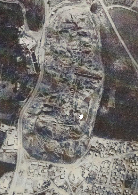 Figure 37
Vertical Air View of the mound of Jericho
click on image to open ina new tab
Kenyon (1978) - Fig. 1 Satellite view
of the Jericho Oasis with the site of Tell es-Sultan and the main geomorphological features from Nigro (2014)
 Figure 1
Satellite view of the Jericho Oasis with the site of Tell es-Sultan and the main geomorphological features
Nigro (2014) - Tell es-Sultan in Google Earth
 Tell es-Sultan
click on image to explore this site on a new tab in Google Earth - Tell es-Sultan on govmap.gov.il
 Tell es-Sultan
click on image to explore this site on a new tab in govmap.gov.il
- Fig. 37 Aerial view of
the mound of Jericho from Kenyon (1978)
Figure 37
Vertical Air View of the mound of Jericho
click on image to open ina new tab
Kenyon (1978) - Fig. 1 Satellite view
of the Jericho Oasis with the site of Tell es-Sultan and the main geomorphological features from Nigro (2014)
Figure 1
Satellite view of the Jericho Oasis with the site of Tell es-Sultan and the main geomorphological features
Nigro (2014) - Tell es-Sultan in Google Earth
Tell es-Sultan
click on image to explore this site on a new tab in Google Earth - Tell es-Sultan on govmap.gov.il
Tell es-Sultan
click on image to explore this site on a new tab in govmap.gov.il
- Fig. 2 Site Plan with
excavations areas of Garstang, Kenyon, and the Italian-Palestinians from Nigro and Taha (2006)
 Figure 2
Tell es-Sultan with the areas excavated by the Italian-Palestinian Expedition (1997-2000) and the Austro-German and British Expeditions.
Click on image to open in a new tab
Nigro and Taha (2006) - Fig. 2 Site Plan from
Nigro (2016)
 Figure 2
Map of Tell es-Sultan/ancient Jericho with excavated areas.
Click on image to open in a new tab
Nigro (2016) - Fig. 6 Site Plan of EB II
(3000–2700 B.C.E) city of Jericho from Nigro (2016)
 Figure 6
Plan of EB II (3000–2700 B.C.E) city of Jericho.
Click on image to open in a new tab
Nigro (2016) - Fig. 8 Site Plan of EB III
city of Jericho from Nigro (2016)
 Figure 8
Reconstructive plan of the EB III city at Tell es-Sultan/Jericho.
Click on image to open in a new tab
Nigro (2016) - Fig. 3 Site Plan from
Kenyon (1957)
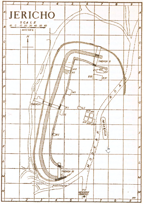 Figure 3
Plan of Jericho
Click on image to open in a new tab
Kenyon (1957) - Site Plan and Excavation Areas
from Kathleen Kenyon in Stern et. al. (1993 v.2)
 Tell es-Sultan: plan of the site and excavation areas
- City wall from Early Bronze Age...
- Retaining wall of glacis...
- Glacis;
- Kenyon's trench I
- Trench II
- Trench III
- Road
- Pools near spring
Click on image to open in a new tab
Stern et. al. (1993 v.2) - Fig. 1 Composite sketch
from Kenyon (1981 v.3a)
 Fig. 1
Composite sketch plan of excavations 1907–1958
Click on image to open in a new tab
Kenyon (1981 v.3a) - Fig. 1 Composite map of
Jericho from Kennedy (2023)
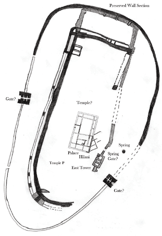 Figure 1
Composite map of the ancient city of Jericho based on multiple excavations
click on image to open in a new tab
Kennedy (2023) - Fig. 2 Plan of Pre-Pottery
Neolithic Town Walls from Kenyon (1981 v.3a)
 Fig. 2
Plan of Pre-Pottery Neolithic Town Walls
Click on image to open in a new tab
Kenyon (1981 v.3a) - Fig. 3 Plan of Early Bronze
Age Town Walls from Kenyon (1981 v.3a)
 Fig. 3
Plan of Early Bronze Age Town Walls
Click on image to open in a new tab
Kenyon (1981 v.3a) - Fig. 4 Plan of Middle Bronze
Age town rampart and revetment from Kenyon (1981 v.3a)
 Fig. 4
Plan of Middle Bronze Age town rampart and revetment
Click on image to open in a new tab
Kenyon (1981 v.3a)
- Fig. 2 Site Plan with
excavations areas of Garstang, Kenyon, and the Italian-Palestinians from Nigro and Taha (2006)
Figure 2
Tell es-Sultan with the areas excavated by the Italian-Palestinian Expedition (1997-2000) and the Austro-German and British Expeditions.
Click on image to open in a new tab
Nigro and Taha (2006) - Fig. 2 Site Plan from
Nigro (2016)
Figure 2
Map of Tell es-Sultan/ancient Jericho with excavated areas.
Photograph and Image by Lorenzo Nigro, © University of Rome “La Sapienza” ROSAPAJ
Click on image to open in a new tab
Nigro (2016) - Fig. 6 Site Plan of EB II
(3000–2700 B.C.E) city of Jericho from Nigro (2016)
Figure 6
Plan of EB II (3000–2700 B.C.E) city of Jericho.
Image by Lorenzo Nigro, © University of Rome “La Sapienza” ROSAPAJ
Click on image to open in a new tab
Nigro (2016) - Fig. 8 Site Plan of EB III
city of Jericho from Nigro (2016)
Figure 8
Reconstructive plan of the EB III city at Tell es-Sultan/Jericho, with Palace G and the nearby temple.
Image by Lorenzo Nigro, © University of Rome “La Sapienza” ROSAPAJ
Click on image to open in a new tab
Nigro (2016) - Fig. 3 Site Plan from
Kenyon (1957)
Figure 3
Plan of Jericho
Click on image to open in a new tab
Kenyon (1957) - Site Plan and Excavation Areas
from Kathleen Kenyon in Stern et. al. (1993 v.2)
Tell es-Sultan: plan of the site and excavation areas
- City wall from Early Bronze Age; in west it is built directly above Neolithic wall
- Retaining wall of glacis from Middle Bronze Age II
- Glacis;
- Kenyon's trench I
- Trench II
- Trench III
- Road
- Pools near spring
Click on image to open in a new tab
Stern et. al. (1993 v.2) - Fig. 1 Composite sketch
from Kenyon (1981 v.3a)
Fig. 1
Composite sketch plan of excavations 1907-1958
Click on image to open in a new tab
Kenyon (1981 v.3a) - Fig. 1 Composite map of
Jericho from Kennedy (2023)
Figure 1
Composite map of the ancient city of Jericho based on multiple excavations
click on image to open in a new tab
Kennedy (2023) - Fig. 2 Plan of Pre-Pottery
Neolithic Town Walls from Kenyon (1981 v.3a)
Fig. 2
Plan of Pre-Pottery Neolithic Town Walls
Click on image to open in a new tab
Kenyon (1981 v.3a) - Fig. 3 Plan of Early Bronze
Age Town Walls from Kenyon (1981 v.3a)
Fig. 3
Plan of Early Bronze Age Town Walls
Click on image to open in a new tab
Kenyon (1981 v.3a) - Fig. 4 Plan of Middle Bronze
Age town rampart and revetment from Kenyon (1981 v.3a)
Fig. 4
Plan of Middle Bronze Age town rampart and revetment
Click on image to open in a new tab
Kenyon (1981 v.3a)
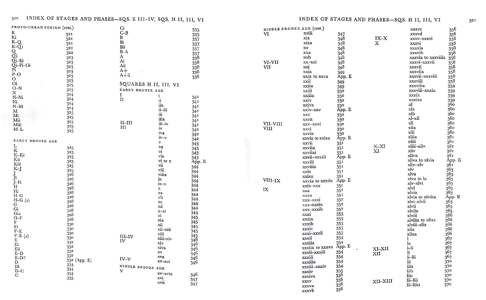
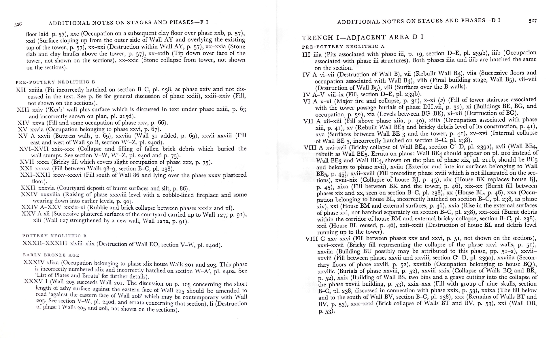
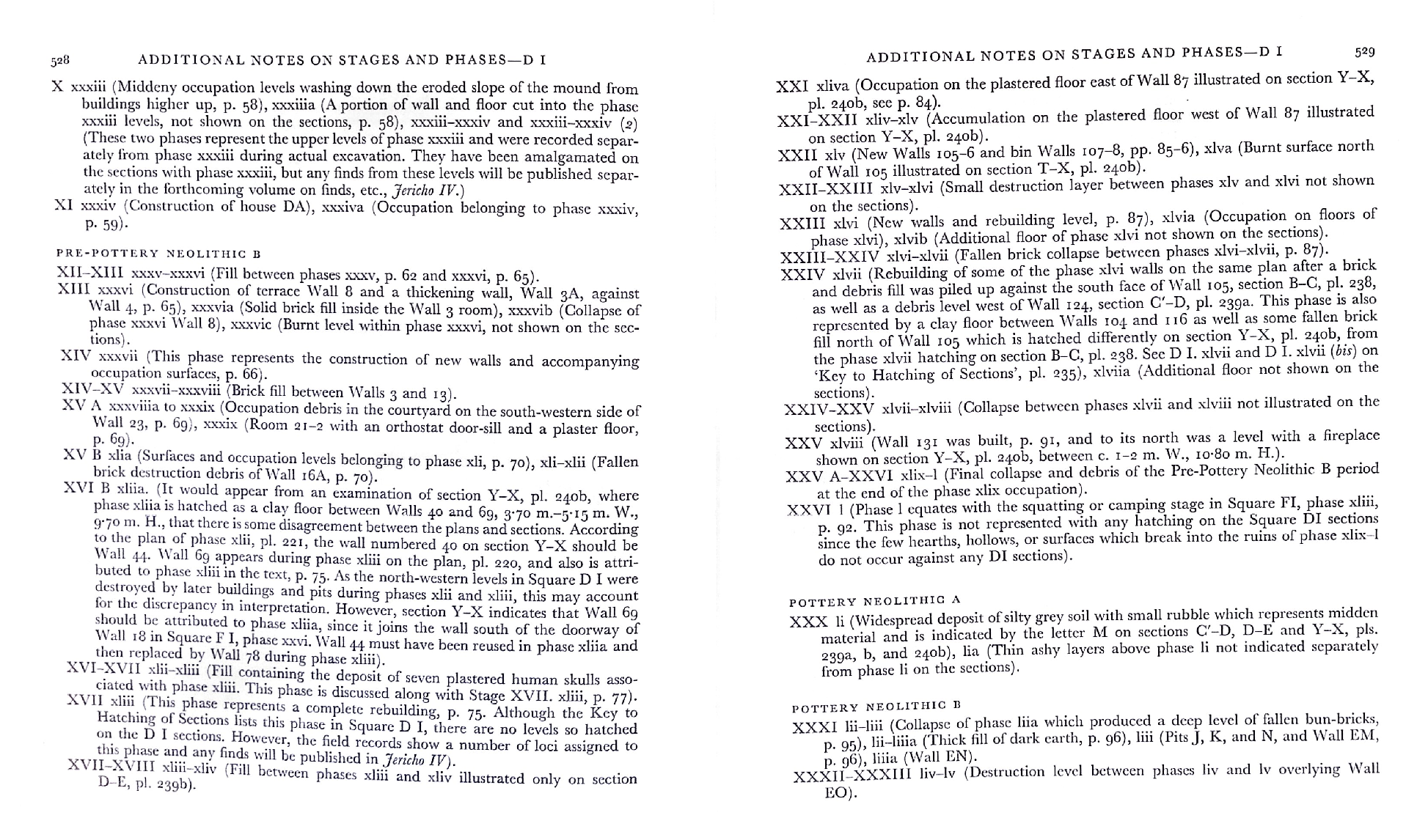
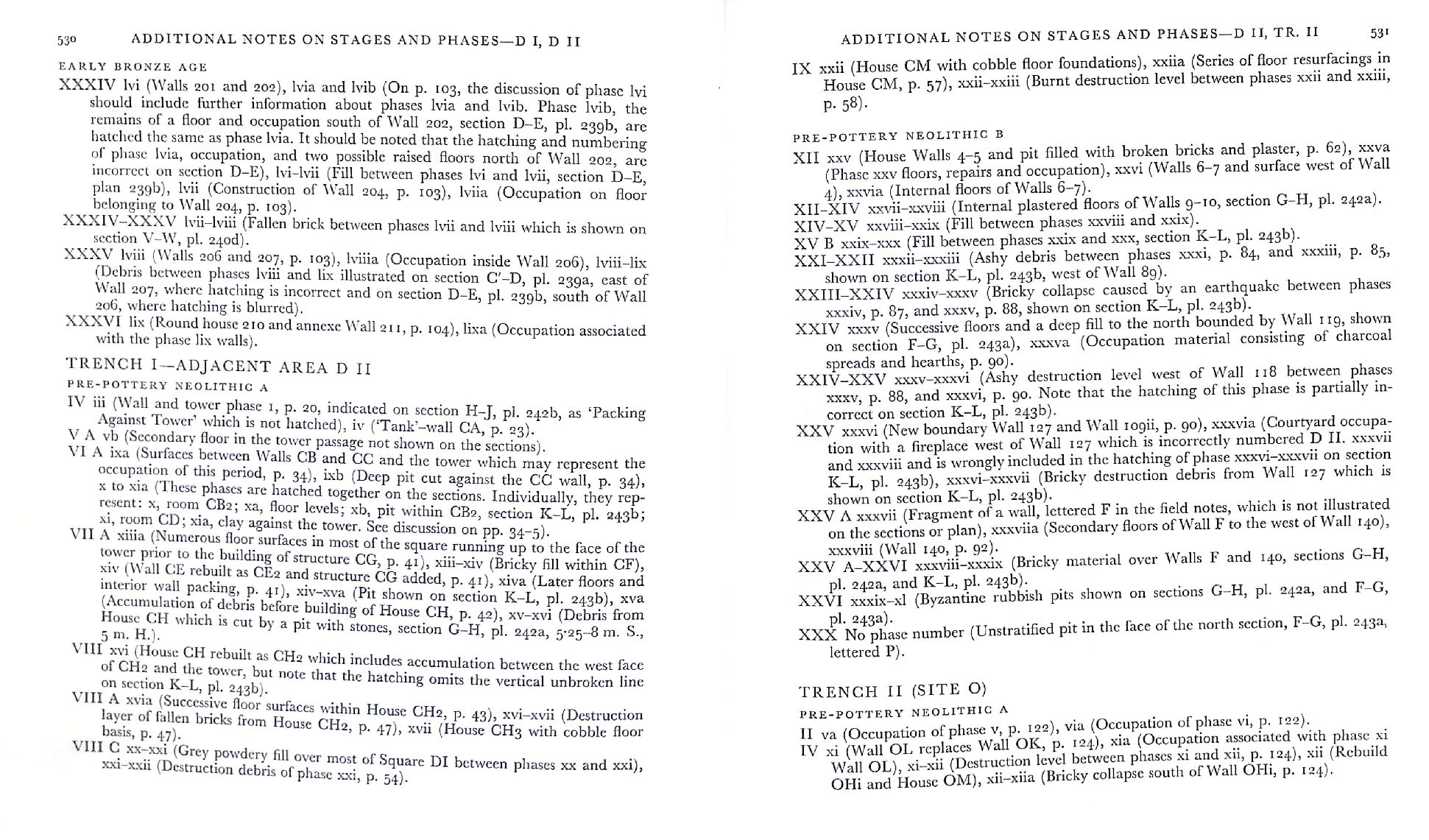
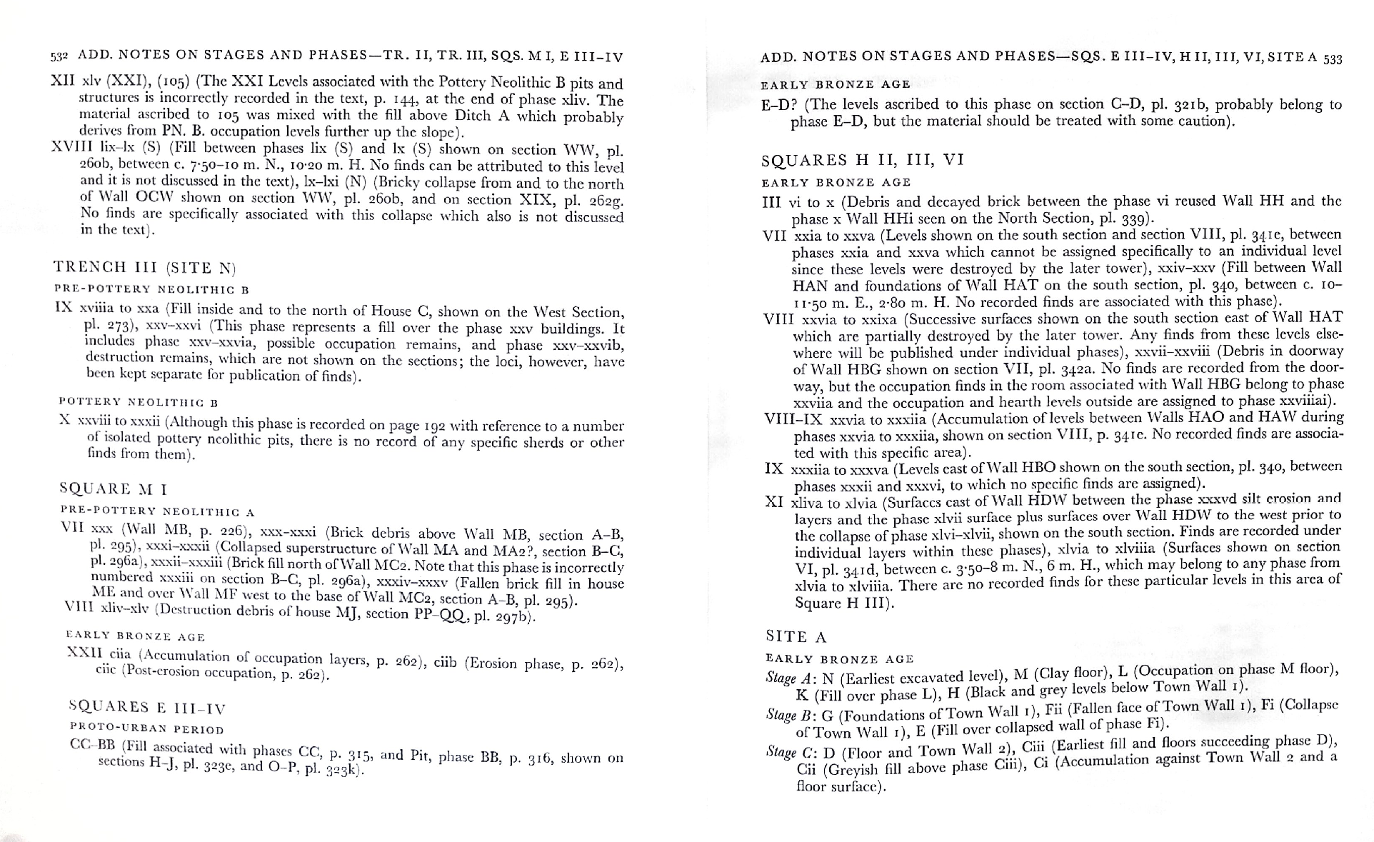
- Pl. 315a Phases M, Mi, and
Q in Squares EIII-IV from Kenyon et al. (1981 Part 2)
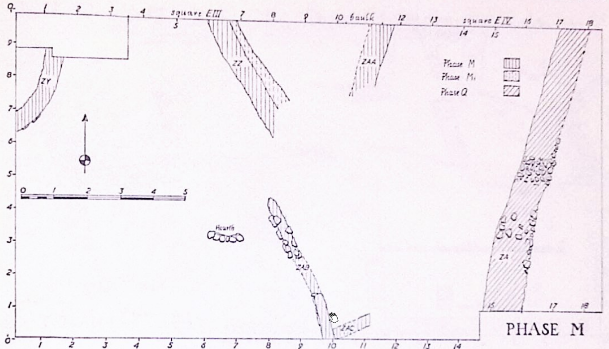 Plate 315a
Squares EIII-IV Plan, Phases M and Mi in hatching key, Phase Q walls re-used
Click on image to open in a new tab
Kenyon et al. (1981 Part 2)
- Pl. 315a Phases M, Mi, and
Q in Squares EIII-IV from Kenyon et al. (1981 Part 2)
Plate 315a
Squares EIII-IV Plan, Phases M and Mi in hatching key, Phase Q walls re-used
Click on image to open in a new tab
Kenyon et al. (1981 Part 2)
- Pl. 267 Trench III Plans
from Kenyon et al. (1981 Part 2)
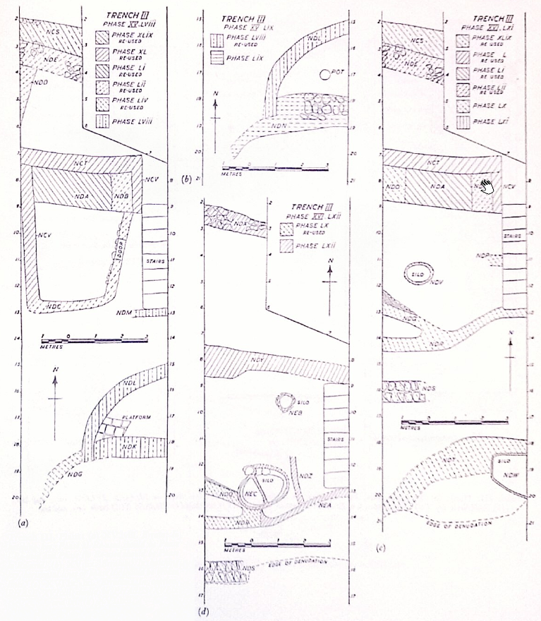 Plate 267
Trench III Plans:
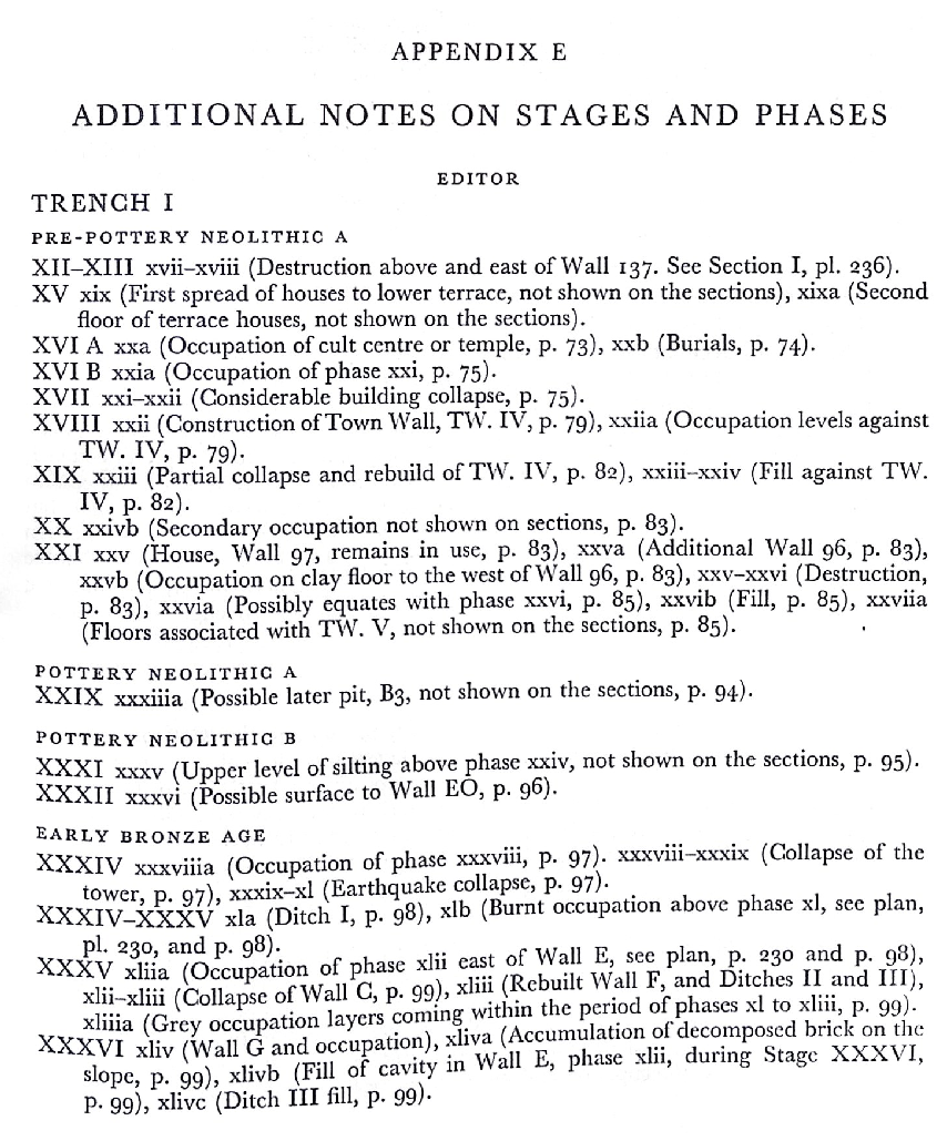
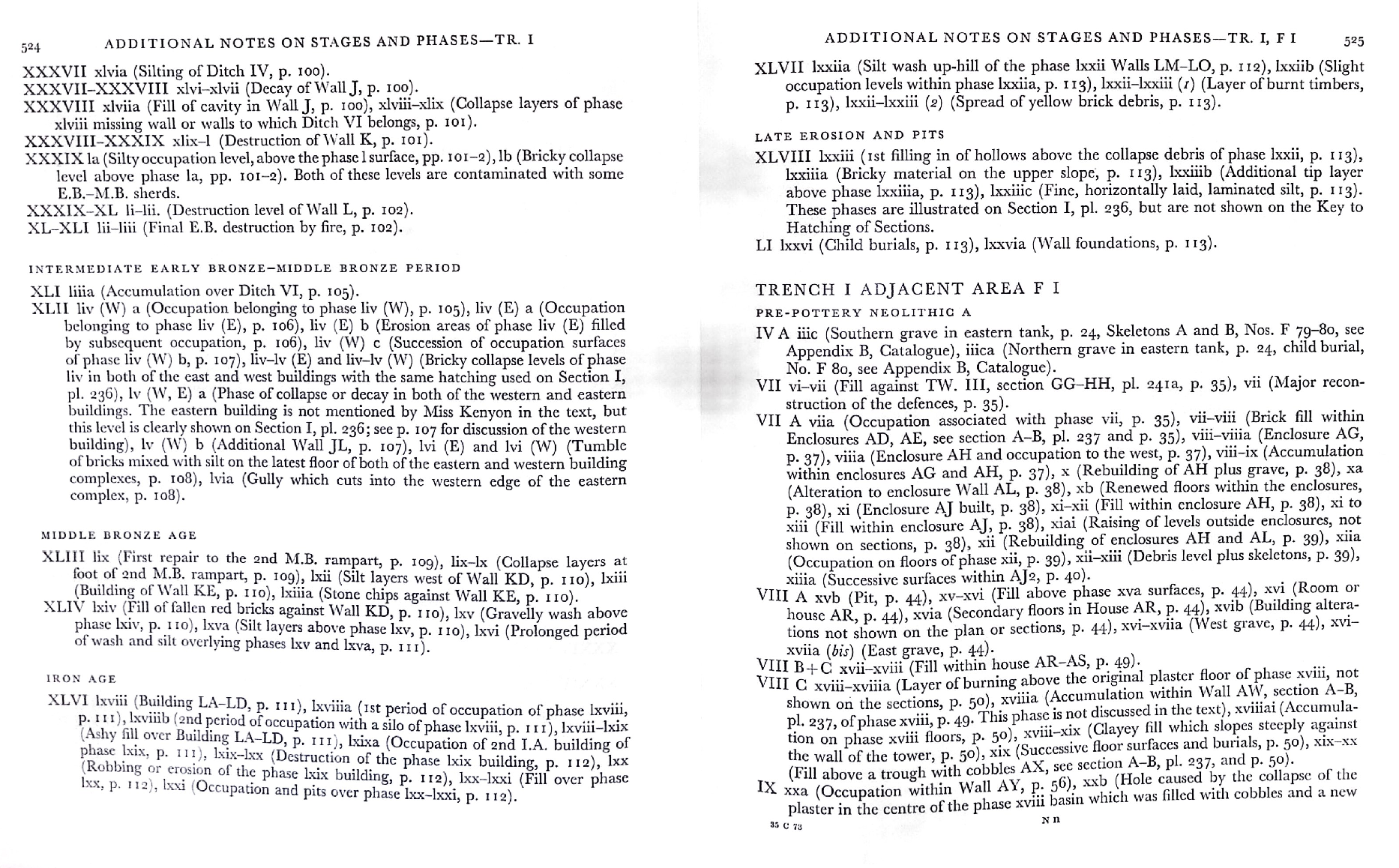
- XV. lviii. Errata: In hatching key, Plate xl Re-used should be Phase l Re-used an Phase liv Re-Used should be Phase lv Re-Used.
- XV.lix. Erraturm: In hatching key, horizontal lines of phase lix should be broken lines
- XVI.lx, lxi. Earratum: In caaption, PHASE XVI.xli should be PHASES XVI.lx and lxi.
- XVI.lxii.
Click on image to open in a new tab
Kenyon et al. (1981 Part 2)
- Pl. 267 Trench III Plans
from Kenyon et al. (1981 Part 2)
Plate 267
Trench III Plans:
- XV. lviii. Errata: In hatching key, Plate xl Re-used should be Phase l Re-used an Phase liv Re-Used should be Phase lv Re-Used.
- XV.lix. Erraturm: In hatching key, horizontal lines of phase lix should be broken lines
- XVI.lx, lxi. Earratum: In caaption, PHASE XVI.xli should be PHASES XVI.lx and lxi.
- XVI.lxii.
Click on image to open in a new tab
Kenyon et al. (1981 Part 2)
- Fig. 55 Middle Building
composite plan from Bienkowski (1986)
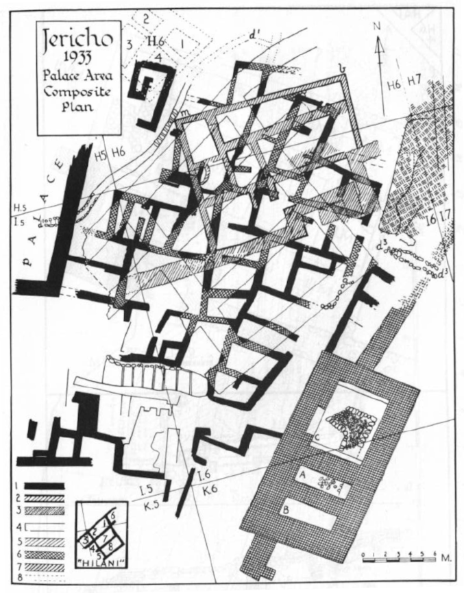 Figure 55
Middle Building area: composite plan (from Garstang 1934. pl.XIII)
- Palace Store-Rooms (MBII)
- Middle Building (LBA)
- Middle Building Over Palace Store-Rooms
- "Hilani" (E.I.A.I.)
- "Hilani" Over Middle Building
- "Hilani" Over Palace Store-Rooms
- "Hilani" Over Middle Building and Palace Store-Rooms
- House In Square H.6
Click on image to open in a new tab
Bienkowski (1986) - Fig. 56 Middle Building
plan and sections from Bienkowski (1986)
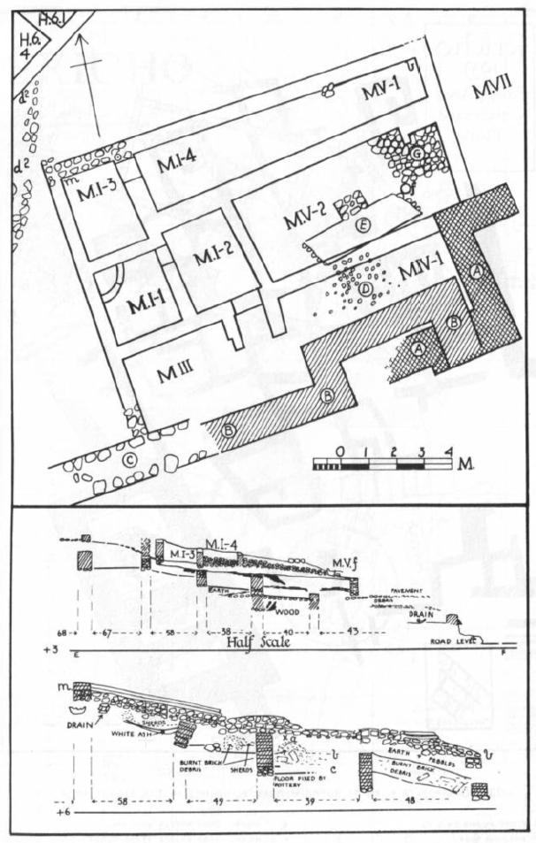 Figure 56
Middle Building plan and section (from Garstang 1934. pl.XIV)
J 33. Plan of Middle Building (M), Sections EF, MB, showing room below
Click on image to open in a new tab
Bienkowski (1986)
- Fig. 55 Middle Building
composite plan from Bienkowski (1986)
Figure 55
Middle Building area: composite plan (from Garstang 1934. pl.XIII)
- Palace Store-Rooms (MBII)
- Middle Building (LBA)
- Middle Building Over Palace Store-Rooms
- "Hilani" (E.I.A.I.)
- "Hilani" Over Middle Building
- "Hilani" Over Palace Store-Rooms
- "Hilani" Over Middle Building and Palace Store-Rooms
- House In Square H.6
Click on image to open in a new tab
Bienkowski (1986) - Fig. 56 Middle Building
plan and sections from Bienkowski (1986)
Figure 56
Middle Building plan and section (from Garstang 1934. pl.XIV)
J 33. Plan of Middle Building (M), Sections EF, MB, showing room below
Click on image to open in a new tab
Bienkowski (1986)
- Fig. 2 Map of coseismic
effects at Tell es-Sultan between 7,500 and 6,000 B.C. from Alfonsi et al. (2012)
 Figure 2
Map of coseismic effects at Tell es-Sultan between 7,500 and 6,000 B.C. (Pre–Pottery Neolithic B). The locations of the effects are marked by numbers (descriptions as in Table 2). Original plan of the Tell modified from Kenyon (1981)
Click on image to open in a new tab
Alfonsi et al. (2012) - Fig. 2 Map of coseismic
effects in Zone A at Tell es-Sultan between 7,500 and 6,000 B.C. from Alfonsi et al. (2012)
 Figure 2
Map of coseismic effects at Tell es-Sultan Zone A between 7,500 and 6,000 B.C. (Pre–Pottery Neolithic B). The locations of the effects are marked by numbers (descriptions as in Table 2). Original plan of the Tell modified from Kenyon (1981)
Click on image to open in a new tab
Alfonsi et al. (2012) - Fig. 2 Map of coseismic
effects in Zone B at Tell es-Sultan between 7,500 and 6,000 B.C. from Alfonsi et al. (2012)
 Figure 2
Map of coseismic effects at Tell es-Sultan Zone B between 7,500 and 6,000 B.C. (Pre–Pottery Neolithic B). The locations of the effects are marked by numbers (descriptions as in Table 2). Original plan of the Tell modified from Kenyon (1981)
Click on image to open in a new tab
Alfonsi et al. (2012) - Fig. 2 Map of coseismic
effects in Entire Tell at Tell es-Sultan between 7,500 and 6,000 B.C. from Alfonsi et al. (2012)
 Figure 2
Map of coseismic effects at Tell es-Sultan (Entire Tell) between 7,500 and 6,000 B.C. (Pre–Pottery Neolithic B). The locations of the effects are marked by numbers (descriptions as in Table 2). Original plan of the Tell modified from Kenyon (1981)
Click on image to open in a new tab
Alfonsi et al. (2012) - Fig. 2 Legend for Map
of coseismic effects at Tell es-Sultan between 7,500 and 6,000 B.C. from Alfonsi et al. (2012)
 Figure 2
Legend for Map of coseismic effects at Tell es-Sultan between 7,500 and 6,000 B.C. (Pre–Pottery Neolithic B). The locations of the effects are marked by numbers (descriptions as in Table 2). Original plan of the Tell modified from Kenyon (1981)
Click on image to open in a new tab
Alfonsi et al. (2012)
- Fig. 2 Map of coseismic
effects at Tell es-Sultan between 7,500 and 6,000 B.C. from Alfonsi et al. (2012)
Figure 2
Map of coseismic effects at Tell es-Sultan between 7,500 and 6,000 B.C. (Pre–Pottery Neolithic B). The locations of the effects are marked by numbers (descriptions as in Table 2). Original plan of the Tell modified from Kenyon (1981)
Click on image to open in a new tab
Alfonsi et al. (2012) - Fig. 2 Map of coseismic
effects in Zone A at Tell es-Sultan between 7,500 and 6,000 B.C. from Alfonsi et al. (2012)
Figure 2
Map of coseismic effects at Tell es-Sultan Zone A between 7,500 and 6,000 B.C. (Pre–Pottery Neolithic B). The locations of the effects are marked by numbers (descriptions as in Table 2). Original plan of the Tell modified from Kenyon (1981)
Click on image to open in a new tab
Alfonsi et al. (2012) - Fig. 2 Map of coseismic
effects in Zone B at Tell es-Sultan between 7,500 and 6,000 B.C. from Alfonsi et al. (2012)
Figure 2
Map of coseismic effects at Tell es-Sultan Zone B between 7,500 and 6,000 B.C. (Pre–Pottery Neolithic B). The locations of the effects are marked by numbers (descriptions as in Table 2). Original plan of the Tell modified from Kenyon (1981)
Click on image to open in a new tab
Alfonsi et al. (2012) - Fig. 2 Map of coseismic
effects in Entire Tell at Tell es-Sultan between 7,500 and 6,000 B.C. from Alfonsi et al. (2012)
Figure 2
Map of coseismic effects at Tell es-Sultan (Entire Tell) between 7,500 and 6,000 B.C. (Pre–Pottery Neolithic B). The locations of the effects are marked by numbers (descriptions as in Table 2). Original plan of the Tell modified from Kenyon (1981)
Click on image to open in a new tab
Alfonsi et al. (2012) - Fig. 2 Legend for Map
of coseismic effects at Tell es-Sultan between 7,500 and 6,000 B.C. from Alfonsi et al. (2012)
Figure 2
Legend for Map of coseismic effects at Tell es-Sultan between 7,500 and 6,000 B.C. (Pre–Pottery Neolithic B). The locations of the effects are marked by numbers (descriptions as in Table 2). Original plan of the Tell modified from Kenyon (1981)
Click on image to open in a new tab
Alfonsi et al. (2012)
- Fig. 4 Section of
Trench 1 from Kenyon (1957)
 Figure 4
Section of Trench 1
Click on image to open in a new tab
Kenyon (1957) - Pl. 236 Section A-B of
Square FI from Kenyon et al. (1981 Part 2)
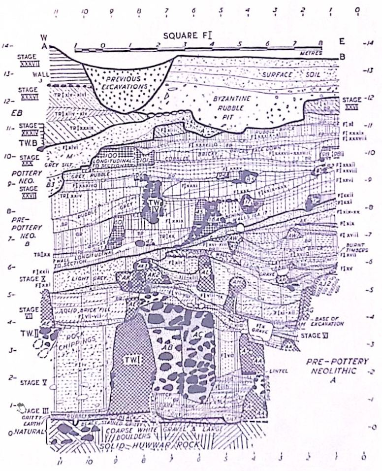 Plate 236
Square FI. Section A-B
Plate 236
Square FI. Section A-B
Erratum: Hatching of diagonally dotted lines incorrect for phase FI.xliii between c. 0.75 m. and 2 m. W., 11.40 m. and 12 m. H. and betweeen c. 6.30 m. and 7.50 m. W., 10.70 m. and 11.20 m. H.
Click on image to open in a new tab
Kenyon et al. (1981 Part 2) - Pl. 240 Tr.I, FI, DI
Sections from Kenyon et al. (1981 Part 2)
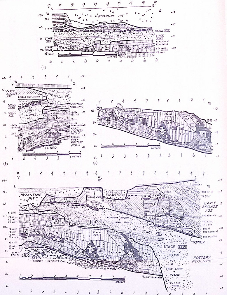
Plate 240
Tr.I, FI, DI. Sections:
- Fl. Section W-A'. Erratum: Phase hatched xlix, betweeen 10.25 m. and 11.80 m. N., 11.80 m. and 12 m. H., should be phase xlixa and is incorrectly hatches
- Dl. Section X-Y
- Fl. Section QQ-RR. Erratum: Phase FI.xxvi should be FI.xxva
- FI, Tr.I. Section V-W, W'-Z. Errata: Phase FI.xxvi, between 3.90 m. and 4.90 m. W., 8.50 m. H., should be FI.xxva. Wall numbered 205 should be 208 and Wall 208 should be 205
Click on image to open in a new tab
Kenyon et al. (1981 Part 2) - Fig. 2 Cross section of
Trench I from Kennedy (2023)
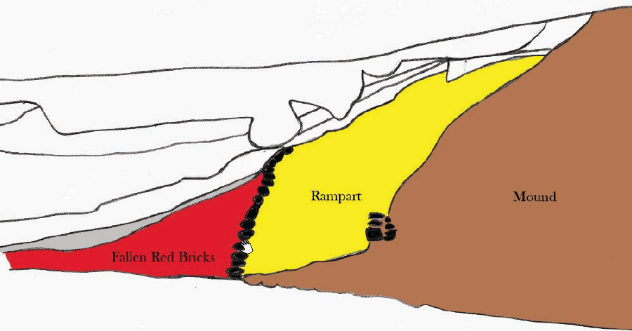 Figure 2
Cross section of Trench I showing the Jericho outer city wall built in Middle Bronze III. The pile of fallen mudbricks in the form of a ramp in front of the stone retaining wall originally comprised a mudbrick wall atop the stone retaining wall.
click on image to open in a new tab
Kennedy (2023)
- Fig. 4 Section of
Trench 1 from Kenyon (1957)
Figure 4
Section of Trench 1
Click on image to open in a new tab
Kenyon (1957) - Pl. 236 Section A-B of
Square FI from Kenyon et al. (1981 Part 2)
Plate 236
Square FI. Section A-B
Erratum: Hatching of diagonally dotted lines incorrect for phase FI.xliii between c. 0.75 m. and 2 m. W., 11.40 m. and 12 m. H. and betweeen c. 6.30 m. and 7.50 m. W., 10.70 m. and 11.20 m. H.
Click on image to open in a new tab
Kenyon et al. (1981 Part 2) - Pl. 240 Tr.I, FI, DI
Sections from Kenyon et al. (1981 Part 2)
Plate 240
Tr.I, FI, DI. Sections:
- Fl. Section W-A'. Erratum: Phase hatched xlix, betweeen 10.25 m. and 11.80 m. N., 11.80 m. and 12 m. H., should be phase xlixa and is incorrectly hatches
- Dl. Section X-Y
- Fl. Section QQ-RR. Erratum: Phase FI.xxvi should be FI.xxva
- FI, Tr.I. Section V-W, W'-Z. Errata: Phase FI.xxvi, between 3.90 m. and 4.90 m. W., 8.50 m. H., should be FI.xxva. Wall numbered 205 should be 208 and Wall 208 should be 205
Click on image to open in a new tab
Kenyon et al. (1981 Part 2) - Fig. 2 Cross section of
Trench I from Kennedy (2023)
Figure 2
Cross section of Trench I showing the Jericho outer city wall built in Middle Bronze III. The pile of fallen mudbricks in the form of a ramp in front of the stone retaining wall originally comprised a mudbrick wall atop the stone retaining wall.
click on image to open in a new tab
Kennedy (2023)
- Plate 273 West Section of
Trench III from Kenyon et al. (1981 Part 2)
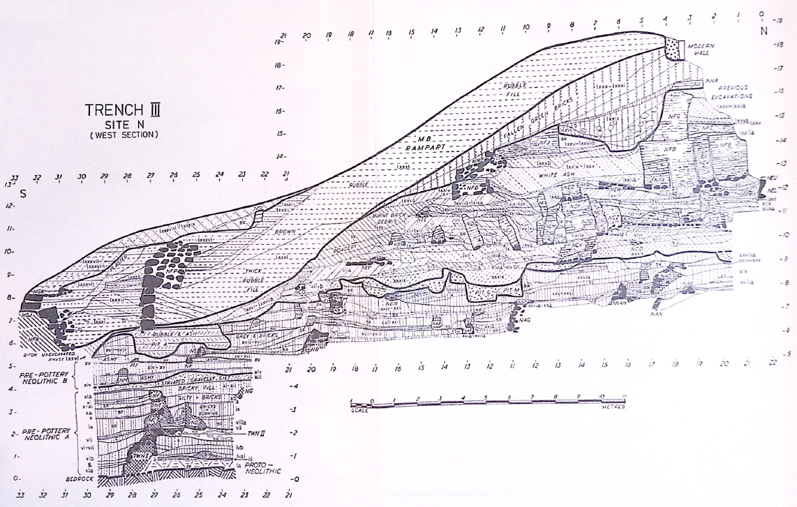 Plate 273
Trench III. West Section. Errata: Metre numbers 0-12 S. at bottom N. end of trench incorrectly numbered 22-12. Lettering of Wall NEN, betweeen 1.60 m. and 2.20 m. S., 11.70 m. H., omitted. Phase lxxvi-lxxviia, between c. 1.50 m. and 3.50 m. S., 15 m. and 16.30 m. H., incorrectly numbered lxxvi-lxxiia.
Click on image to open in a new tab
Kenyon et al. (1981 Part 2) - Plate 274 East Section of
Trench III from Kenyon et al. (1981 Part 2)
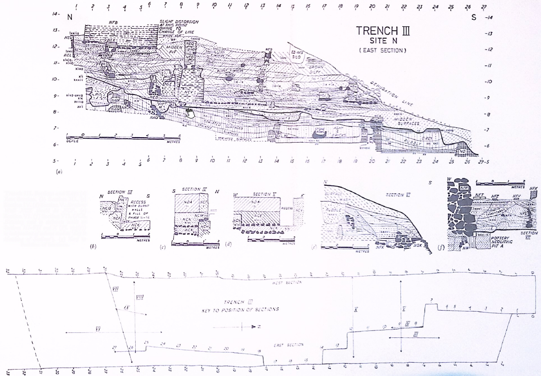 Plate 274
Trench III. Sections and Key.
- East Section
- Section III
- Section IV
- Section V. Erratum: Wall NCE should be NCP.
- Section VI
- Section VII (N.B. Hatching used to deliniate walls on Sections III-VII and X (Pl. 275(c)) is independent of scheme used on 'Key to Hatching of Sections')
- Key to Positi0n of Sections
Click on image to open in a new tab
Kenyon et al. (1981 Part 2)
- Plate 273 West Section of
Trench III from Kenyon et al. (1981 Part 2)
Plate 273
Trench III. West Section. Errata: Metre numbers 0-12 S. at bottom N. end of trench incorrectly numbered 22-12. Lettering of Wall NEN, betweeen 1.60 m. and 2.20 m. S., 11.70 m. H., omitted. Phase lxxvi-lxxviia, between c. 1.50 m. and 3.50 m. S., 15 m. and 16.30 m. H., incorrectly numbered lxxvi-lxxiia.
Click on image to open in a new tab
Kenyon et al. (1981 Part 2) - Plate 274 East Section of
Trench III from Kenyon et al. (1981 Part 2)
Plate 274
Trench III. Sections and Key.
- East Section
- Section III
- Section IV
- Section V. Erratum: Wall NCE should be NCP.
- Section VI
- Section VII (N.B. Hatching used to deliniate walls on Sections III-VII and X (Pl. 275(c)) is independent of scheme used on 'Key to Hatching of Sections')
- Key to Positi0n of Sections
Click on image to open in a new tab
Kenyon et al. (1981 Part 2)
- Fig. 4 Archaeoseismic
stratigraphic sections from Alfonsi et al. (2012)
 Figure 4
Archaeoseismic stratigraphic sections modified from Garstang and Garstang (1948) and Kenyon (1981). Dashed squares in Garstang’s section are the approximate projections of Kenyon’s excavations both from zone A (logs in the inset) and zone B. The time— space relations between the layers and the observed coseismic effects (point numbers as in Figure 2 and Table 2) are illustrated. Horizons of the seismic shaking events recognized within the Pre-Pottery Neolithic B period are marked by stars.
Click on image to open in a new tab
Alfonsi et al. (2012) - Plate VI Section
through the Excavated Area in the Northeast Corner from Garstang and Garstang (1948)
 Plate VI
Section through the Excavated Area in the Northeast Corner
Click on image to open in a new tab
Garstang and Garstang (1948)
- Fig. 4 Archaeoseismic
stratigraphic sections from Alfonsi et al. (2012)
Figure 4
Archaeoseismic stratigraphic sections modified from Garstang and Garstang (1948) and Kenyon (1981). Dashed squares in Garstang’s section are the approximate projections of Kenyon’s excavations both from zone A (logs in the inset) and zone B. The time— space relations between the layers and the observed coseismic effects (point numbers as in Figure 2 and Table 2) are illustrated. Horizons of the seismic shaking events recognized within the Pre-Pottery Neolithic B period are marked by stars.
Click on image to open in a new tab
Alfonsi et al. (2012) - Plate VI Section
through the Excavated Area in the Northeast Corner from Garstang and Garstang (1948)
Plate VI
Section through the Excavated Area in the Northeast Corner
Click on image to open in a new tab
Garstang and Garstang (1948)
- Pl. 343a South Section of
Site A from Kenyon et al. (1981 Part 2)
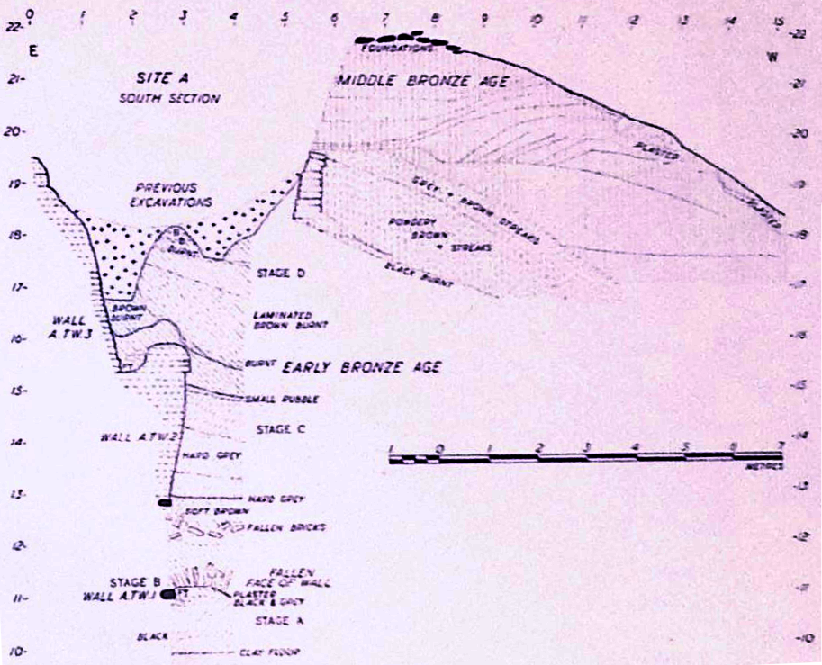 Plate 343a
Site A, South Section
Click on image to open in a new tab
Kenyon et al. (1981 Part 2)
- Pl. 343a South Section of
Site A from Kenyon et al. (1981 Part 2)
Plate 343a
Site A, South Section
Click on image to open in a new tab
Kenyon et al. (1981 Part 2)
- Pl. 321 Section from Squares
EIII-IV from Kenyon et al. (1981 Part 2)
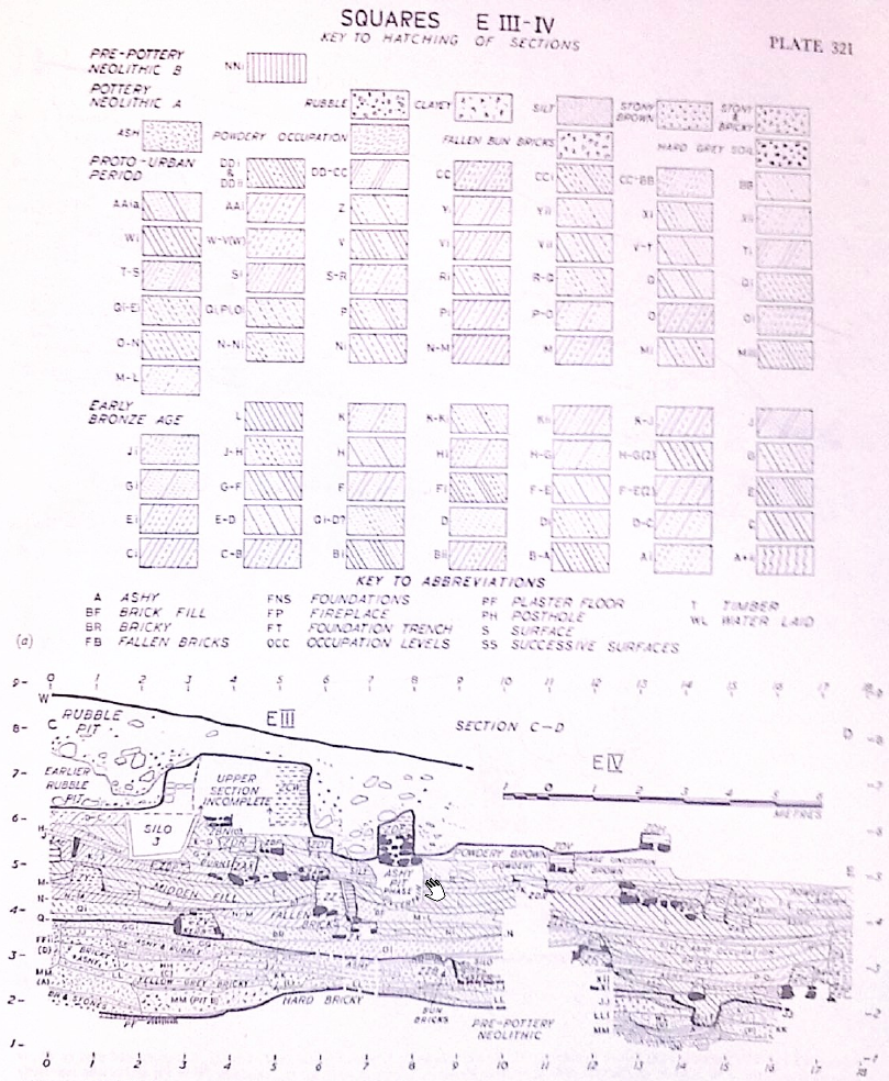
Plate 321
Squares EIII-IV, Keys and Section
- Key to Hatching of Sections and Key to Abbreviations. Errata: Phase Ji should be broken and three dotted diagonal lines. Hatching lettered phase Qi–D? should be E-D?. Hatching duplicated on sections for Phases Vi and Kii, Phases V–T and M, Phases R–Q and Di, Phases Pi and Ci.
- North Section C–D. Errata: Broken Lettering of Pit Bii, between c. 2 m. and 4 m. E., 2.3 m. n., H., omitted. Phase lettered GGi, between 0.25 m. and 6 m. E., should be GGib. Hatching of Phase Ji, between c. 15.30 m. and 17/60 m. E., 4 m. H., incorrect.
Click on image to open in a new tab
Kenyon et al. (1981 Part 2) - Pl. 323 Sections from Squares
EIII-IV from Kenyon et al. (1981 Part 2)
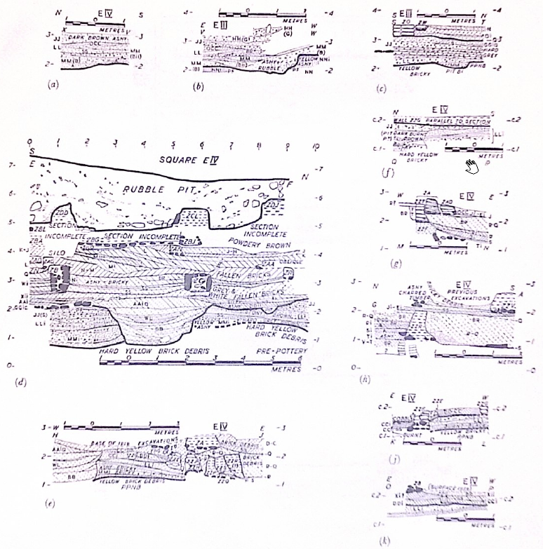
Plate 323
Squares EIII-IV, Sections:
- Section X–V. Erratum: Location square, EIV, should be EIII.
- Section V-W
- Section S–T
- Section E–F. Errata: Phase Hatched M Mi, between 5.75 m. and 9.89 m. N, 1.50 m. H., should be M Mii. slight error on the hatching of Phase Miii between 3.50 m. and 4 m.,N., 3.75 m. H.
- Section H–J. Erratum: Phase Q, between 2.10 m and 2.60 m H. on east of section, is incorrectly hatched and lettered and should be altered to Phases Qi-Ei
- Section Q–R
- Section N–M. Erratum: Phases Ji-Ei at c. 2.20 m. H. should be Qi-Ei
- Section G–A. Erratum: Phases Ji-Ei at c. 2.10 m. H. should be Qi-Ei
- Section K–L
- Section O–P
Click on image to open in a new tab
Kenyon et al. (1981 Part 2)
- Pl. 321 Section from Squares
EIII-IV from Kenyon et al. (1981 Part 2)
Plate 321
Squares EIII-IV, Keys and Section
- Key to Hatching of Sections and Key to Abbreviations. Errata: Phase Ji should be broken and three dotted diagonal lines. Hatching lettered phase Qi–D? should be E-D?. Hatching duplicated on sections for Phases Vi and Kii, Phases V–T and M, Phases R–Q and Di, Phases Pi and Ci.
- North Section C–D. Errata: Broken Lettering of Pit Bii, between c. 2 m. and 4 m. E., 2.3 m. n., H., omitted. Phase lettered GGi, between 0.25 m. and 6 m. E., should be GGib. Hatching of Phase Ji, between c. 15.30 m. and 17/60 m. E., 4 m. H., incorrect.
Click on image to open in a new tab
Kenyon et al. (1981 Part 2) - Pl. 323 Sections from Squares
EIII-IV from Kenyon et al. (1981 Part 2)
Plate 323
Squares EIII-IV, Sections:
- Section X–V. Erratum: Location square, EIV, should be EIII.
- Section V-W
- Section S–T
- Section E–F. Errata: Phase Hatched M Mi, between 5.75 m. and 9.89 m. N, 1.50 m. H., should be M Mii. slight error on the hatching of Phase Miii between 3.50 m. and 4 m.,N., 3.75 m. H.
- Section H–J. Erratum: Phase Q, between 2.10 m and 2.60 m H. on east of section, is incorrectly hatched and lettered and should be altered to Phases Qi-Ei
- Section Q–R
- Section N–M. Erratum: Phases Ji-Ei at c. 2.20 m. H. should be Qi-Ei
- Section G–A. Erratum: Phases Ji-Ei at c. 2.10 m. H. should be Qi-Ei
- Section K–L
- Section O–P
Click on image to open in a new tab
Kenyon et al. (1981 Part 2)
- Fig. 22 Section of the
tumbled down EB III city-wall from Nigro (2014)
 Figure 22
Section of the tumbled down EB III city-wall at time of Garstang’s excavations (after Garstang - Garstang 1948, pl. XVIII)
Click on image to open in a new tab
Nigro (2014)
- Fig. 22 Section of the
tumbled down EB III city-wall from Nigro (2014)
Figure 22
Section of the tumbled down EB III city-wall at time of Garstang’s excavations (after Garstang - Garstang 1948, pl. XVIII)
Click on image to open in a new tab
Nigro (2014)
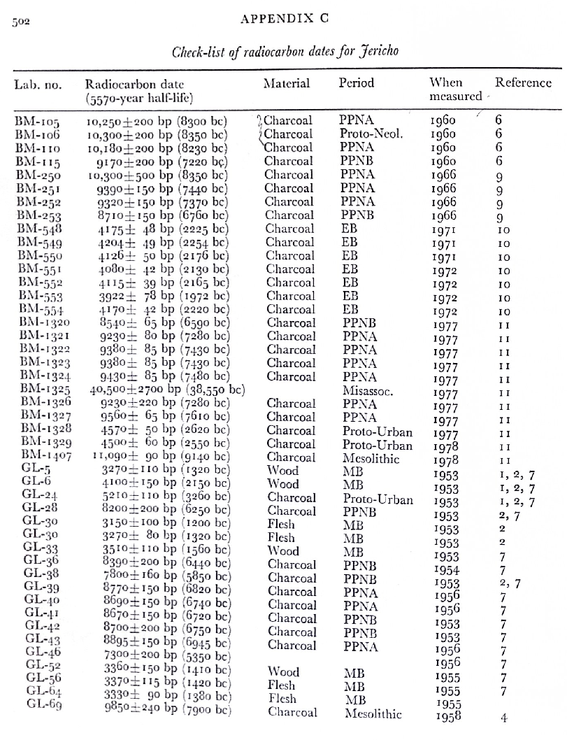
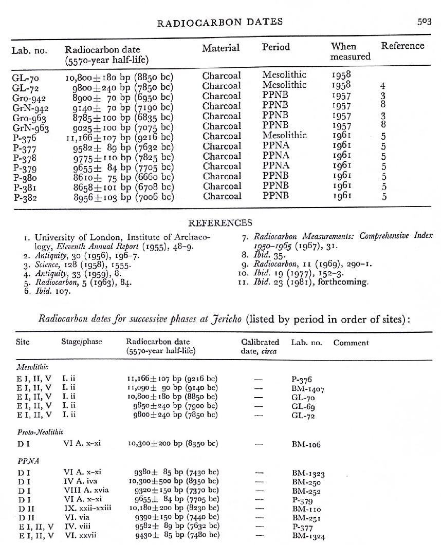
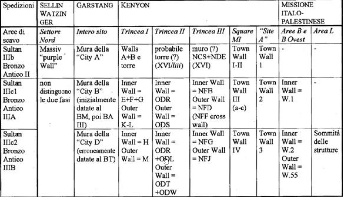 Table 2
Stratigraphic subdivision of the defensive structures brought to light by the various expeditions to Jericho.
click on image to open in a new tab
Nigro (2006c)
- Fig. 1 Oblique Aerial View
of Tell es-Sultan from Nigro (2016)
 Figure 1
General view of the site of Tell es-Sultan, from the south.
Photograph and Image by Lorenzo Nigro, © University of Rome “La Sapienza” ROSAPAJ
click on image to open in a new tab
Nigro (2016) - Fig. 3a Coseismic Effects
Photo from Alfonsi et al. (2012)
 Figure 3a
Photos illustrating some of the effects caused by seismic shaking at Tell es-Sultan (numbered as in Figure 2 and Table 2).
(a) Black arrows point to fractures crossing the floor and the perimeter wall of Pre-Pottery Neolithic B houses. Original picture from Kenyon (1981).
click on image to open in a new tab
Alfonsi et al. (2012) - Fig. 3b Coseismic Effects
Photo from Alfonsi et al. (2012)
 Figure 3b
Photos illustrating some of the effects caused by seismic shaking at Tell es-Sultan (numbered as in Figure 2 and Table 2).
(b) Human skeleton found under a collapsed wall. Original picture from Kenyon (1981).
click on image to open in a new tab
Alfonsi et al. (2012) - Fig. 3c Coseismic Effects
Photo from Alfonsi et al. (2012)
 Figure 3c
Photos illustrating some of the effects caused by seismic shaking at Tell es-Sultan (numbered as in Figure 2 and Table 2).
(c) View from the top of a complete northward collapse of a wall, giving the illusion of a pavement. Original picture from Kenyon (1981).
click on image to open in a new tab
Alfonsi et al. (2012) - Fig. 3d Coseismic Effects
Photo from Alfonsi et al. (2012)
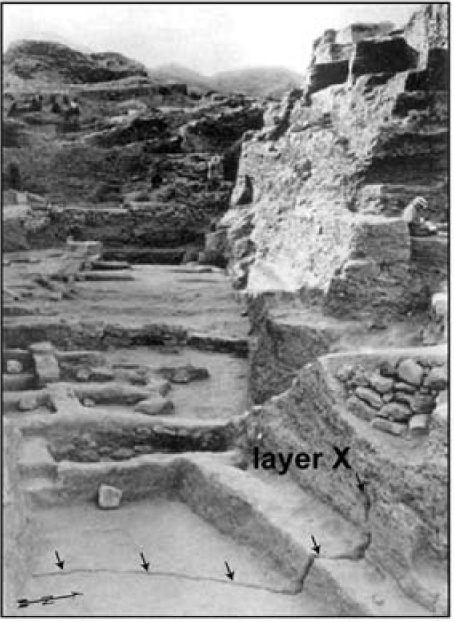 Figure 3d
Photos illustrating some of the effects caused by seismic shaking at Tell es-Sultan (numbered as in Figure 2 and Table 2).
(d) East view of the Garstang excavation. Visible in the foreground is a fracture crossing the floor and the adjacent wall affecting layer X, dated as the latest stage of Pre–Pottery Neolithic B. Original picture from Garstang and Garstang (1948).
click on image to open in a new tab
Alfonsi et al. (2012) - Fig. 3e Coseismic Effects
Photo from Alfonsi et al. (2012)
 Figure 3e
Photos illustrating some of the effects caused by seismic shaking at Tell es-Sultan (numbered as in Figure 2 and Table 2).
(e) The Garstang excavation as appears today (same shot position). Original picture from Garstang and Garstang (1948).
click on image to open in a new tab
Alfonsi et al. (2012) - Fig. 3f Coseismic Effects
Photo from Alfonsi et al. (2012)
 Figure 3f
Photos illustrating some of the effects caused by seismic shaking at Tell es-Sultan (numbered as in Figure 2 and Table 2).
(f) Black arrows point to a fracture crossing a pavement and a skeleton. An apparent displacement of skull versus body is observable. The white circle inscribes the possible correspondence between the cervical and neck bones (black dots). Original picture from Garstang and Garstang (1948).
click on image to open in a new tab
Alfonsi et al. (2012) - Fig. 2 General View of
Area A and sampling of destruction layer F.1688 west of Tower A1 from Nigro and Taha (2013)
 Figure 2
General view of Area A (2013): sampling destruction layer F.1688 west of Tower A1, from south.
click on image to open in a new tab
Nigro and Taha (2013) - Fig. 3 Mudbricks visible
on the northern face of Tower A1 Wall W.15 with possible destruction layer above from Nigro and Taha (2013)
 Figure 3
Mudbricks visible on the northern face of Tower A1 Wall W.15; the stretcher one (left) measures 0.59 m, the header 0.36 m.
click on image to open in a new tab
Nigro and Taha (2013) - Fig. 7 Earthquake crack
from Nigro (2014)
 Figure 7
The earthquake crack of Stage XIII.liii in Kenyon’s Square EI(after Kenyon 1981, pl. 160b)
click on image to open in a new tab
Nigro (2014) - Fig. 8 Earthquake crack
from Nigro (2014)
 Figure 8
The earthquake crack n Garstang’s North-Eastern Trench (after Garstang - Garstang 1948, pl. VIIa)
click on image to open in a new tab
Nigro (2014) - Fig. 18 Collapsed mudbricks
from Nigro (2014)
 Figure 18
EB IIIA Inner Gate L.1800, filled up with collapsed mudbricks and burnt beams, from north-east
click on image to open in a new tab
Nigro (2014) - Fig. 20 EB IIIB final
destruction in Palace G from Nigro (2014)
 Figure 20
Evidence of the EB IIIB final destruction in Palace G
click on image to open in a new tab
Nigro (2014) - Fig. 21 tumbled down
EB III city-wall from Nigro (2014)
 Figure 21
The tumbled down EB III city-wall (after Garstang - Garstang1948, pl. XVIIa)
click on image to open in a new tab
Nigro (2014) - Fig. 22 Section of the
tumbled down EB III city-wall from Nigro (2014)
 Figure 22
Section of the tumbled down EB III city-wall at time of Garstang’s excavations (after Garstang - Garstang 1948, pl. XVIII)
click on image to open in a new tab
Nigro (2014) - Fig. 23 EB IIIB final
destruction in Building B1 from Nigro (2014)
 Figure 23
Evidence of the EB IIIB final destruction in Building B1, built at the south-western corner of the EB III city, just inside the EB III city-wall.
click on image to open in a new tab
Nigro (2014) - Plate 200a Collapsed bricks
at Site A from Kenyon et al. (1981)
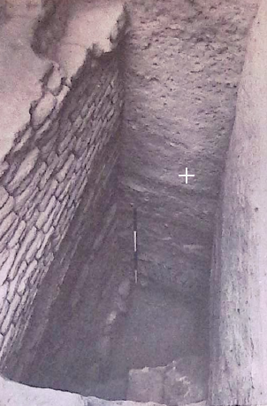 Plate 200a
Site A. At base, by foot of survey pole, stone foundations of lowest wall reached, with the collapse of the brick superstructure to right (pp. 372 ff)
click on image to open ina new tab
Kenyon et al. (1981) - Plate 200b Collapsed bricks
at Site A from Kenyon et al. (1981)
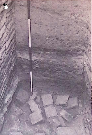 Plate 200b
Site A. At base, by foot of survey pole, stone foundations of lowest wall reached, with the collapse of the brick superstructure to right (pp. 372 ff/)
click on image to open in a new tab
Kenyon et al. (1981) - Fig. 16 Collapsed bricks
at Site A from Nigro (2014)
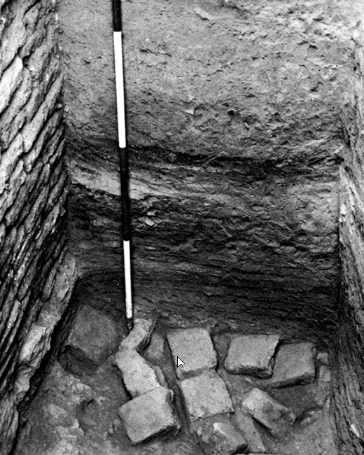 Figure 16
Dune-yellowish mudbricks tumble down from the EB II city wall at Kenyon’s Site A
(after Kenyon 1981, pl. 200b).
click on image to open in a new tab
Nigro (2014) - Plate 201a 3rd wall cutting
into top of 2nd wall at Site A from Kenyon et al. (1981)
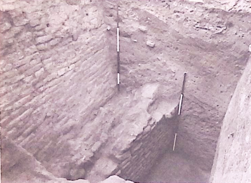 Plate 201a
Site A. On left, 3rd wall cutting into top of 2nd wall (p.374)
click on image to open in a new tab
Kenyon et al. (1981) - Plate 201b 3rd wall cutting
into wall below at Site A from Kenyon et al. (1981)
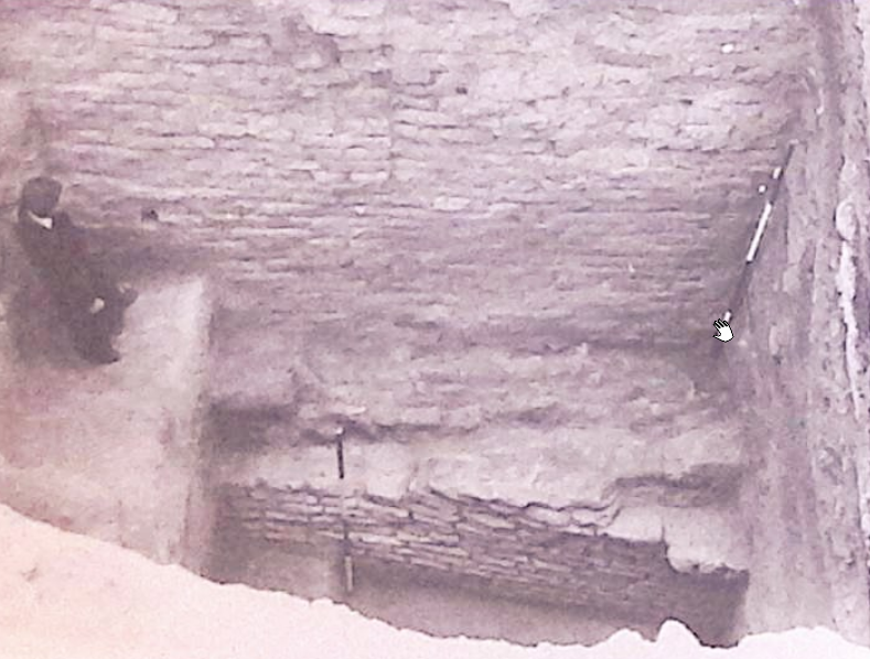 Plate 201b
Site A. and wall below, cut into by 3rd wall. A rebuild runs from the right up to a straight joint (p. 374)
click on image to open in a new tab
Kenyon et al. (1981) - Plate 79b Tower built
against Town Wall A from Kenyon et al. (1981)
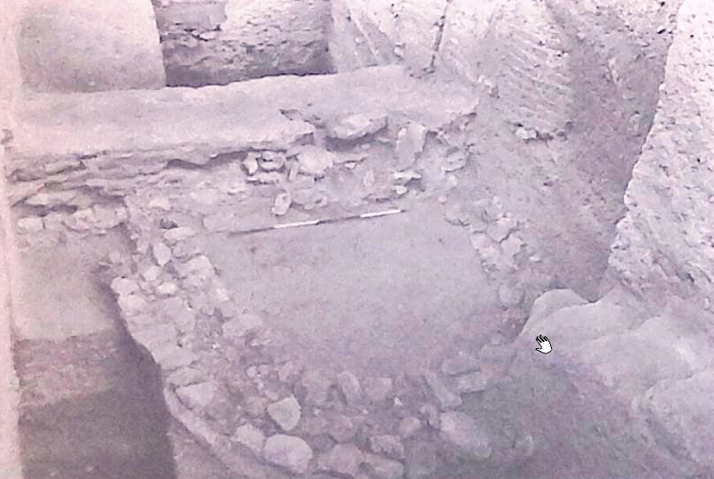 Plate 79b
Tower built against Town Wall A (p. 97)
click on image to open in a new tab
Kenyon et al. (1981) - Plate 80a Foundations of
tower and face of Town Wall B from Kenyon et al. (1981)
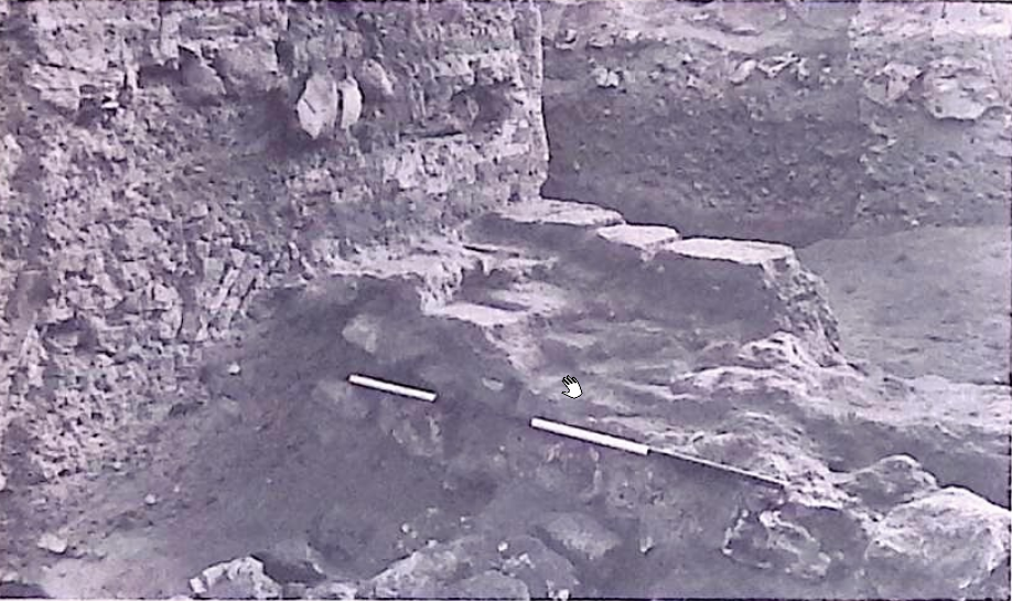 Plate 80a
Foundations of tower and face of Town Wall B (p. 97)
click on image to open in a new tab
Kenyon et al. (1981) - Plate 100a Stone foundation
of phase Tr.II.xlviii house OBM from Kenyon et al. (1981)
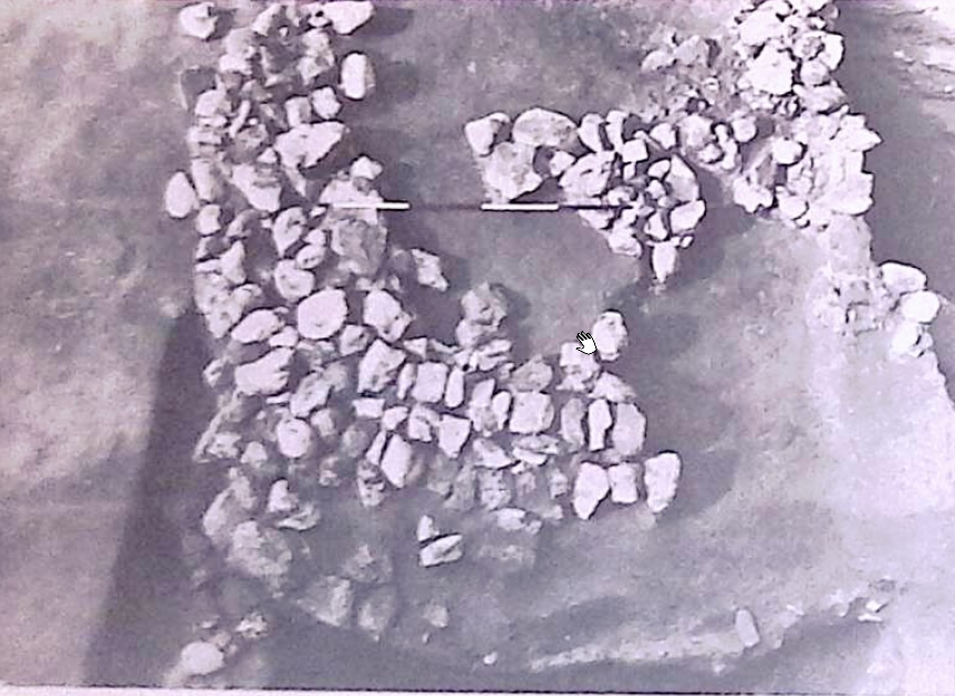 Plate 100a
Stone foundation of phase Tr.II.xlviii house OBM (p.146)
click on image to open in a new tab
Kenyon et al. (1981) - Fig. 38 Collapsed town wall
of the Early Bronze Age from Kenyon (1978)
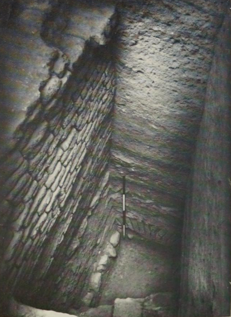 Figure 38
Example of a town wall of the Early Bronze Age destroyed by an earthquake. At the base, beside the survey pole, the stone foundations and, spreading to the right, the face of the brick wall collapsed onto the contemporary surface.
click on image to open in a new tab
Kenyon (1978) - Fig. 38 Annotated version of
the collapsed town wall of the Early Bronze Age from Kenyon (1978) and modified by JW
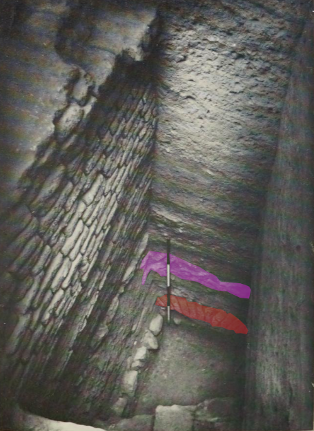 Figure 38
Example of a town wall of the Early Bronze Age destroyed by an earthquake. JW: Ordered fall of mud-bricks from the face of the town wall is shaded red while the disordered wall of mud-bricks from the core of the wall is shaded pink.
click on image to open in a new tab
Kenyon (1978) - Fig. 18 Collapsed bricks
and burnt beams in EB IIIA Inner Gate from Nigro (2014)
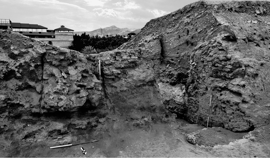 Figure 18
EB IIIA Inner Gate L.1800, filled up with collapsed mudbricks and burnt beams, from north-east.
click on image to open in a new tab
Nigro (2014) - Fig. 3 Outer wall of Jericho
from Kennedy (2023)
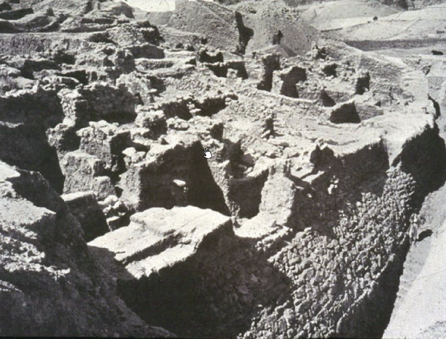 Figure 3
Houses of mudbrick built up against the outer wall at Jericho
Photo from the Sellin and Watzinger excavations.
click on image to open in a new tab
Kennedy (2023) - Fig. 4 Final Bronze Age
destruction layer from Kennedy (2023)
 Figure 4
Stratigraphic section of the final Bronze Age destruction layer at Jericho from a Kenyon excavated square on the eastern side of the city, showing collapsed building materials, pottery, charcoal, and ash.
click on image to open in a new tab
Kennedy (2023) - Fig. 5 Burned storage jars
full of grain uncovered in the fire destruction layer of Jericho 1Vc from Kennedy (2023)
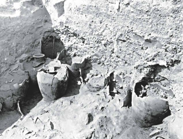 Figure 5
Burned storage jars full of grain uncovered in the fire destruction layer of Jericho 1Vc
Found and photographed in the excavations under Garstang.
click on image to open in a new tab
Kennedy (2023) - Fig. 9 The "Middle Building"
at Jericho from Kennedy (2023)
 Figure 9
The "Middle Building" at Jericho, excavated and photographed by Garstang and dated to the Late Bronze IIA or the 14th century BC
click on image to open in a new tab
Kennedy (2023) - Pl. 62A Middle Bronze Buildings
overlain by wash of burnt material from Kenyon (1957)
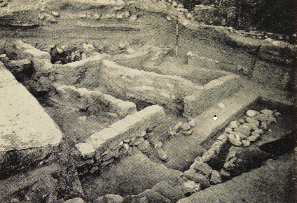 Plate 62A
Buildings of Middle Bronze age Jericho, destroyed by fire. In background the wash of burnt material which overlay them.
click on image to open in a new tab
Kenyon (1957) - Pl. 62A Middle Bronze Buildings
overlain by wash of burnt material (annotated) from Kenyon (1957)
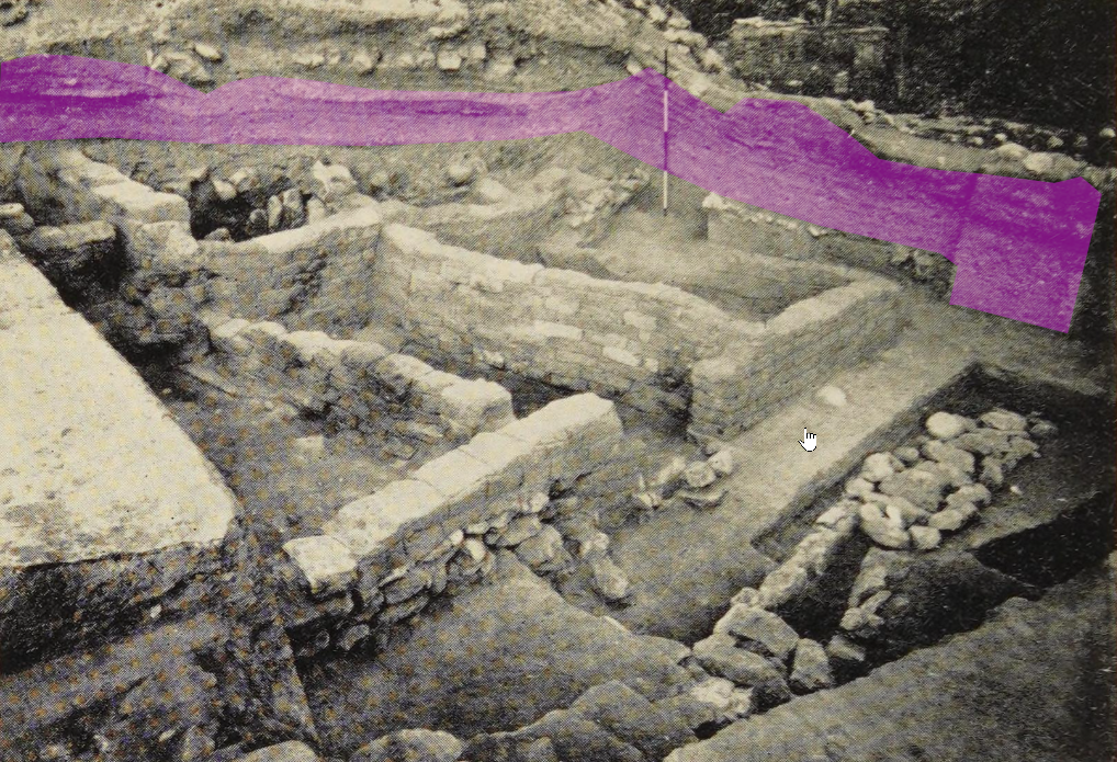 Plate 62A
Buildings of Middle Bronze age Jericho, destroyed by fire. In background the wash of burnt material which overlay them.
Burnt material shaded pink (by JW)
click on image to open in a new tab
Kenyon (1957)
- Fig. 1 Oblique Aerial View
of Tell es-Sultan from Nigro (2016)
Figure 1
General view of the site of Tell es-Sultan, from the south.
Photograph and Image by Lorenzo Nigro, © University of Rome “La Sapienza” ROSAPAJ
click on image to open in a new tab
Nigro (2016) - Fig. 3a Coseismic Effects
Photo from Alfonsi et al. (2012)
Figure 3a
Photos illustrating some of the effects caused by seismic shaking at Tell es-Sultan (numbered as in Figure 2 and Table 2).
(a) Black arrows point to fractures crossing the floor and the perimeter wall of Pre-Pottery Neolithic B houses. Original picture from Kenyon (1981).
click on image to open in a new tab
Alfonsi et al. (2012) - Fig. 3b Coseismic Effects
Photo from Alfonsi et al. (2012)
Figure 3b
Photos illustrating some of the effects caused by seismic shaking at Tell es-Sultan (numbered as in Figure 2 and Table 2).
(b) Human skeleton found under a collapsed wall. Original picture from Kenyon (1981).
click on image to open in a new tab
Alfonsi et al. (2012) - Fig. 3c Coseismic Effects
Photo from Alfonsi et al. (2012)
Figure 3c
Photos illustrating some of the effects caused by seismic shaking at Tell es-Sultan (numbered as in Figure 2 and Table 2).
(c) View from the top of a complete northward collapse of a wall, giving the illusion of a pavement. Original picture from Kenyon (1981).
click on image to open in a new tab
Alfonsi et al. (2012) - Fig. 3d Coseismic Effects
Photo from Alfonsi et al. (2012)
Figure 3d
Photos illustrating some of the effects caused by seismic shaking at Tell es-Sultan (numbered as in Figure 2 and Table 2).
(d) East view of the Garstang excavation. Visible in the foreground is a fracture crossing the floor and the adjacent wall affecting layer X, dated as the latest stage of Pre–Pottery Neolithic B. Original picture from Garstang and Garstang (1948).
click on image to open in a new tab
Alfonsi et al. (2012) - Fig. 3e Coseismic Effects
Photo from Alfonsi et al. (2012)
Figure 3e
Photos illustrating some of the effects caused by seismic shaking at Tell es-Sultan (numbered as in Figure 2 and Table 2).
(e) The Garstang excavation as appears today (same shot position). Original picture from Garstang and Garstang (1948).
click on image to open in a new tab
Alfonsi et al. (2012) - Fig. 3f Coseismic Effects
Photo from Alfonsi et al. (2012)
Figure 3f
Photos illustrating some of the effects caused by seismic shaking at Tell es-Sultan (numbered as in Figure 2 and Table 2).
(f) Black arrows point to a fracture crossing a pavement and a skeleton. An apparent displacement of skull versus body is observable. The white circle inscribes the possible correspondence between the cervical and neck bones (black dots). Original picture from Garstang and Garstang (1948).
click on image to open in a new tab
Alfonsi et al. (2012) - Fig. 2 General View of
Area A and sampling of destruction layer F.1688 west of Tower A1 from Nigro and Taha (2013)
Figure 2
General view of Area A (2013): sampling destruction layer F.1688 west of Tower A1, from south.
click on image to open in a new tab
Nigro and Taha (2013) - Fig. 3 Mudbricks visible
on the northern face of Tower A1 Wall W.15 with possible destruction layer above from Nigro and Taha (2013)
Figure 3
Mudbricks visible on the northern face of Tower A1 Wall W.15; the stretcher one (left) measures 0.59 m, the header 0.36 m.
click on image to open in a new tab
Nigro and Taha (2013) - Fig. 7 Earthquake crack
from Nigro (2014)
Figure 7
The earthquake crack of Stage XIII.liii in Kenyon’s Square EI(after Kenyon 1981, pl. 160b)
click on image to open in a new tab
Nigro (2014) - Fig. 8 Earthquake crack
from Nigro (2014)
Figure 8
The earthquake crack n Garstang’s North-Eastern Trench (after Garstang - Garstang 1948, pl. VIIa)
click on image to open in a new tab
Nigro (2014) - Fig. 18 Collapsed mudbricks
from Nigro (2014)
Figure 18
EB IIIA Inner Gate L.1800, filled up with collapsed mudbricks and burnt beams, from north-east
click on image to open in a new tab
Nigro (2014) - Fig. 20 EB IIIB final
destruction in Palace G from Nigro (2014)
Figure 20
Evidence of the EB IIIB final destruction in Palace G
click on image to open in a new tab
Nigro (2014) - Fig. 21 tumbled down
EB III city-wall from Nigro (2014)
Figure 21
The tumbled down EB III city-wall (after Garstang - Garstang1948, pl. XVIIa)
click on image to open in a new tab
Nigro (2014) - Fig. 22 Section of the
tumbled down EB III city-wall from Nigro (2014)
Figure 22
Section of the tumbled down EB III city-wall at time of Garstang’s excavations (after Garstang - Garstang 1948, pl. XVIII)
click on image to open in a new tab
Nigro (2014) - Fig. 23 EB IIIB final
destruction in Building B1 from Nigro (2014)
Figure 23
Evidence of the EB IIIB final destruction in Building B1, built at the south-western corner of the EB III city, just inside the EB III city-wall.
click on image to open in a new tab
Nigro (2014) - Plate 200a Collapsed bricks
at Site A from Kenyon et al. (1981)
Plate 200a
Site A. At base, by foot of survey pole, stone foundations of lowest wall reached, with the collapse of the brick superstructure to right (pp. 372 ff)
click on image to open in a new tab
Kenyon et al. (1981) - Plate 200b Collapsed bricks
at Site A from Kenyon et al. (1981)
Plate 200b
Site A. At base, by foot of survey pole, stone foundations of lowest wall reached, with the collapse of the brick superstructure to right (pp. 372 ff/)
click on image to open in a new tab
Kenyon et al. (1981) - Fig. 16 Collapsed bricks
at Site A from Nigro (2014)
Figure 16
Dune-yellowish mudbricks tumble down from the EB II city wall at Kenyon’s Site A
(after Kenyon 1981, pl. 200b).
click on image to open in a new tab
Nigro (2014) - Plate 201a 3rd wall cutting
into top of 2nd wall at Site A from Kenyon et al. (1981)
Plate 201a
Site A. On left, 3rd wall cutting into top of 2nd wall (p.374)
click on image to open in a new tab
Kenyon et al. (1981) - Plate 201b 3rd wall cutting
into wall below at Site A from Kenyon et al. (1981)
Plate 201b
Site A. and wall below, cut into by 3rd wall. A rebuild runs from the right up to a straight joint (p. 374)
click on image to open in a new tab
Kenyon et al. (1981) - Plate 79b Tower built
against Town Wall A from Kenyon et al. (1981)
Plate 79b
Tower built against Town Wall A (p. 97)
click on image to open in a new tab
Kenyon et al. (1981) - Plate 80a Foundations of
tower and face of Town Wall B from Kenyon et al. (1981)
Plate 80a
Foundations of tower and face of Town Wall B (p. 97)
click on image to open in a new tab
Kenyon et al. (1981) - Plate 100a Stone foundation
of phase Tr.II.xlviii house OBM from Kenyon et al. (1981)
Plate 100a
Stone foundation of phase Tr.II.xlviii house OBM (p.146)
click on image to open in a new tab
Kenyon et al. (1981) - Fig. 38 Collapsed town wall
of the Early Bronze Age from Kenyon (1978)
Figure 38
Example of a town wall of the Early Bronze Age destroyed by an earthquake. At the base, beside the survey pole, the stone foundations and, spreading to the right, the face of the brick wall collapsed onto the contemporary surface.
click on image to open in a new tab
Kenyon (1978) - Fig. 38 Annotated version of
the collapsed town wall of the Early Bronze Age from Kenyon (1978) and modified by JW
Figure 38
Example of a town wall of the Early Bronze Age destroyed by an earthquake. JW: Ordered fall of mud-bricks from the face of the town wall is shaded red while the disordered wall of mud-bricks from the core of the wall is shaded pink.
click on image to open in a new tab
Kenyon (1978) - Fig. 18 Collapsed bricks
and burnt beams in EB IIIA Inner Gate from Nigro (2014)
Figure 18
EB IIIA Inner Gate L.1800, filled up with collapsed mudbricks and burnt beams, from north-east.
click on image to open in a new tab
Nigro (2014) - Fig. 3 Outer wall of Jericho
from Kennedy (2023)
Figure 3
Houses of mudbrick built up against the outer wall at Jericho
Photo from the Sellin and Watzinger excavations.
click on image to open in a new tab
Kennedy (2023) - Fig. 4 Final Bronze Age
destruction layer from Kennedy (2023)
Figure 4
Stratigraphic section of the final Bronze Age destruction layer at Jericho from a Kenyon excavated square on the eastern side of the city, showing collapsed building materials, pottery, charcoal, and ash.
click on image to open in a new tab
Kennedy (2023) - Fig. 5 Burned storage jars
full of grain uncovered in the fire destruction layer of Jericho 1Vc from Kennedy (2023)
Figure 5
Burned storage jars full of grain uncovered in the fire destruction layer of Jericho 1Vc
Found and photographed in the excavations under Garstang.
click on image to open in a new tab
Kennedy (2023) - Fig. 9 The "Middle Building"
at Jericho from Kennedy (2023)
Figure 9
The "Middle Building" at Jericho, excavated and photographed by Garstang and dated to the Late Bronze IIA or the 14th century BC
click on image to open in a new tab
Kennedy (2023) - Pl. 62A Middle Bronze Buildings
overlain by wash of burnt material from Kenyon (1957)
Plate 62A
Buildings of Middle Bronze age Jericho, destroyed by fire. In background the wash of burnt material which overlay them.
click on image to open in a new tab
Kenyon (1957) - Pl. 62A Middle Bronze Buildings
overlain by wash of burnt material (annotated) from Kenyon (1957)
Plate 62A
Buildings of Middle Bronze age Jericho, destroyed by fire. In background the wash of burnt material which overlay them.
Burnt material shaded pink (by JW)
click on image to open in a new tab
Kenyon (1957)
- from Nigro (2016)
 Table 1
Correlation between Archaeological Periodization and the Stratigraphic Phases of the Italian-Palestinian Expedition at Tell es-Sultan/Ancient Jericho
Click on image to open in a new tab
Nigro (2016)
- from Nigro (2006)
 Table 1
Correlation between Kenyon’s periodization and the stratigraphic phases of the Italian-Palestinian Expedition.
Click on image to open in a new tab
Nigro (2006)
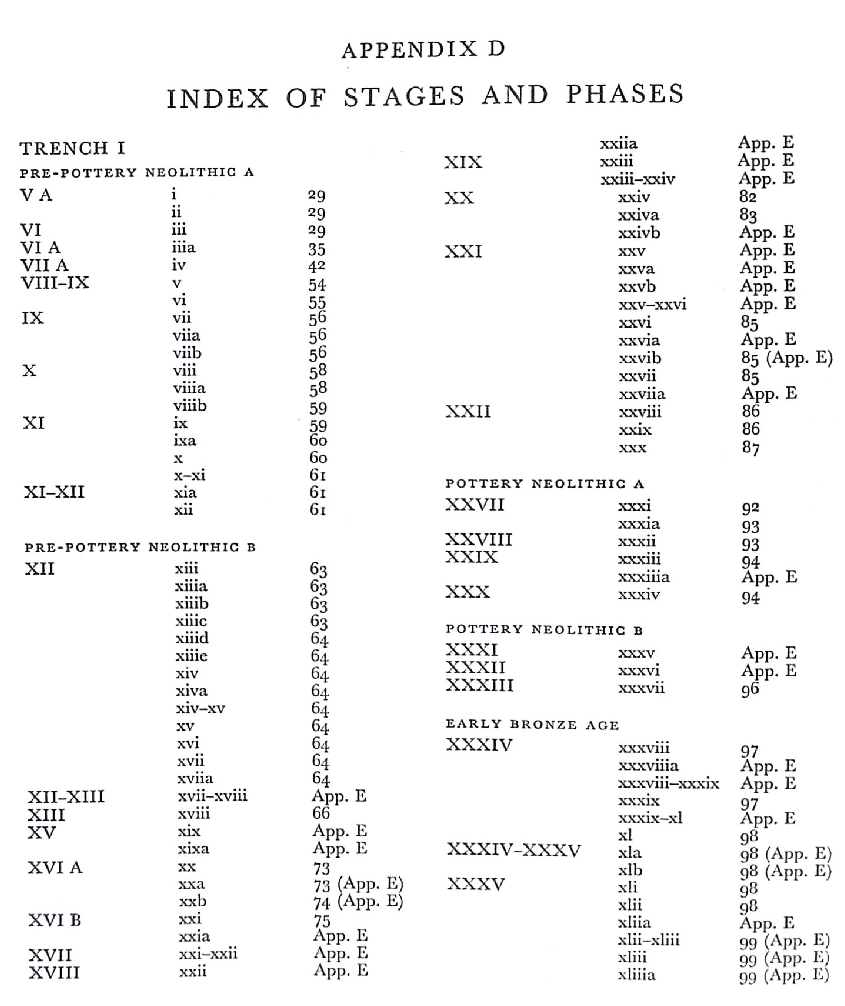
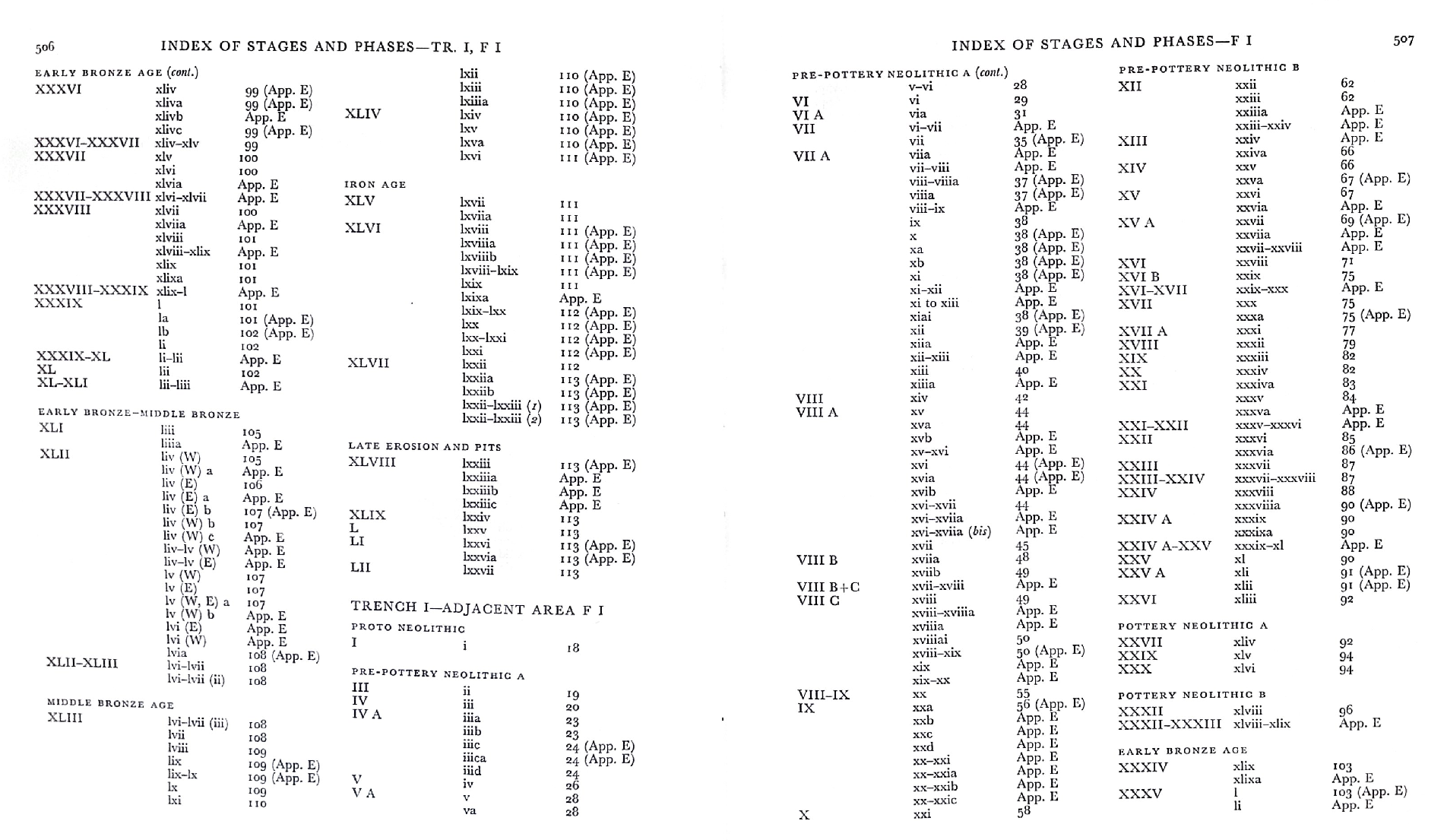
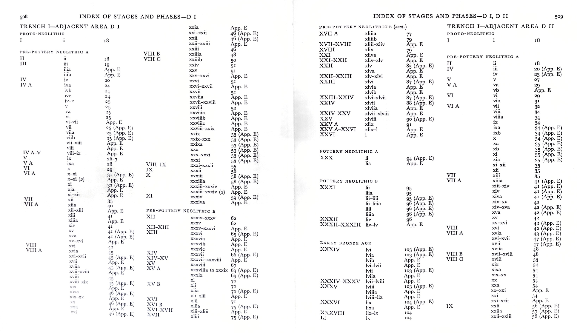
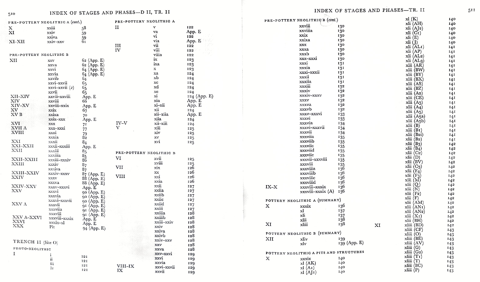
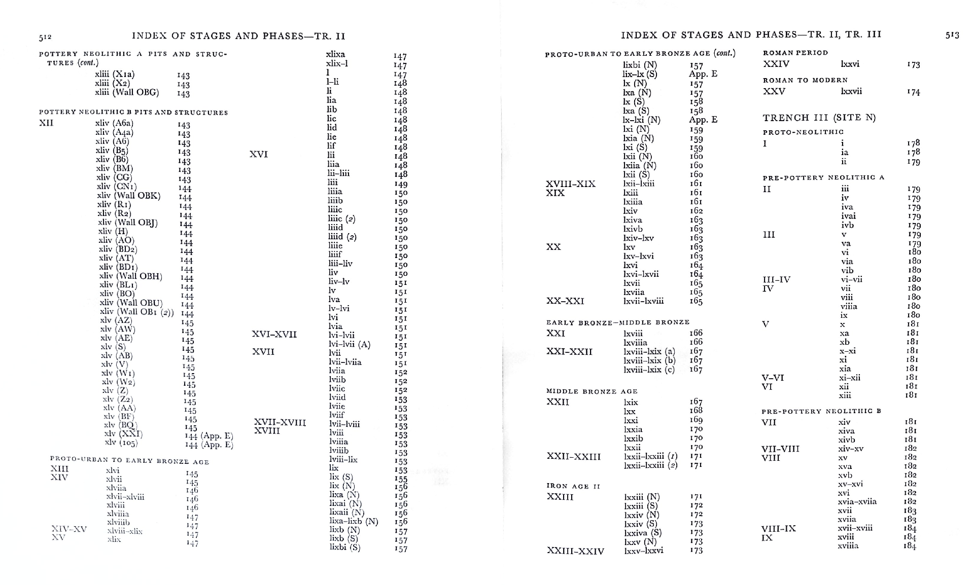
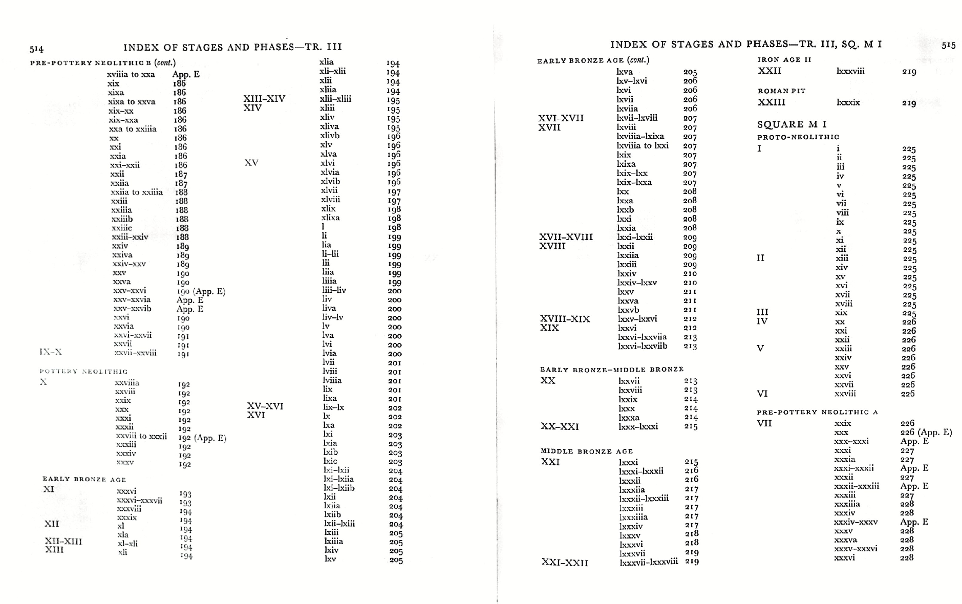
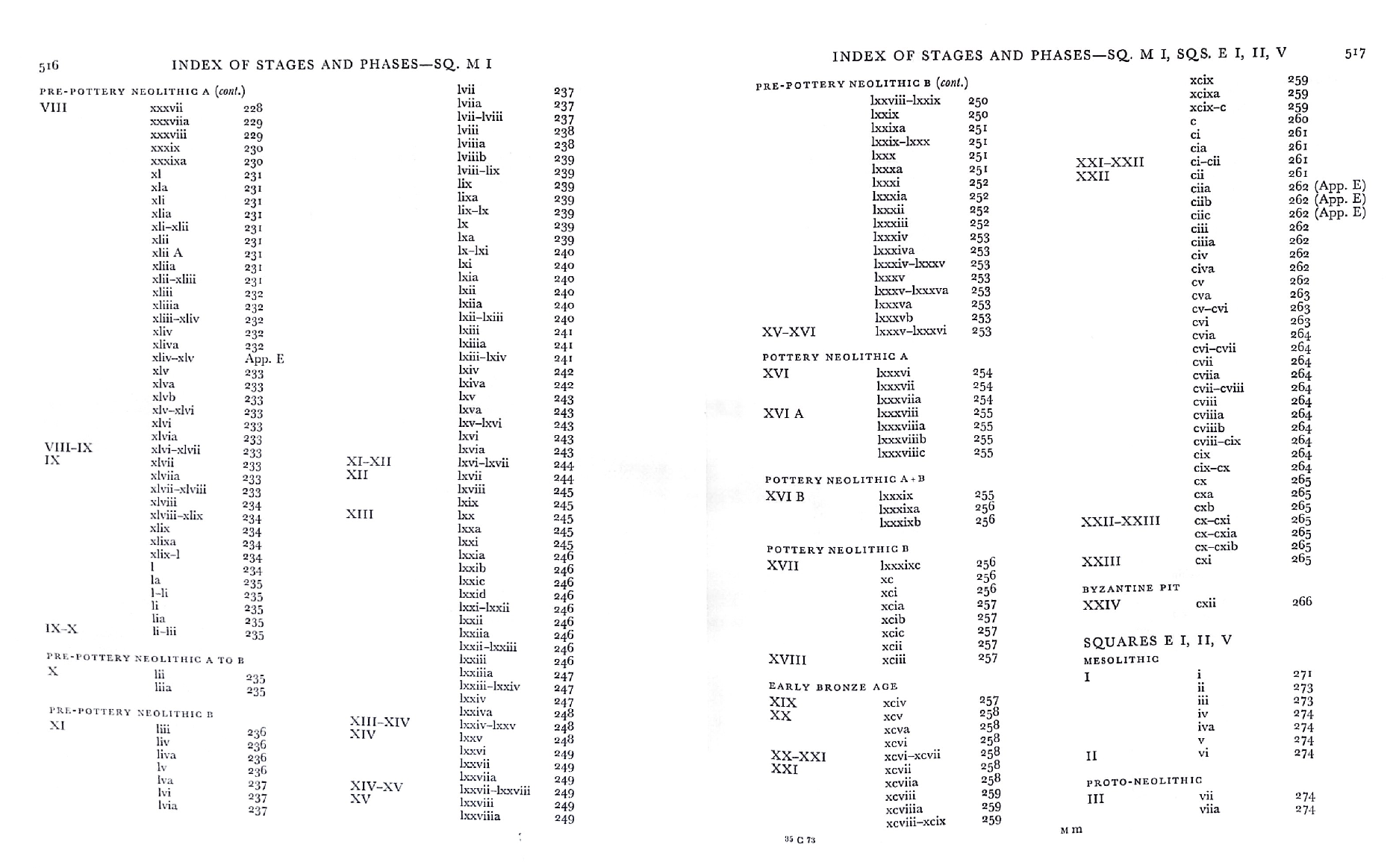
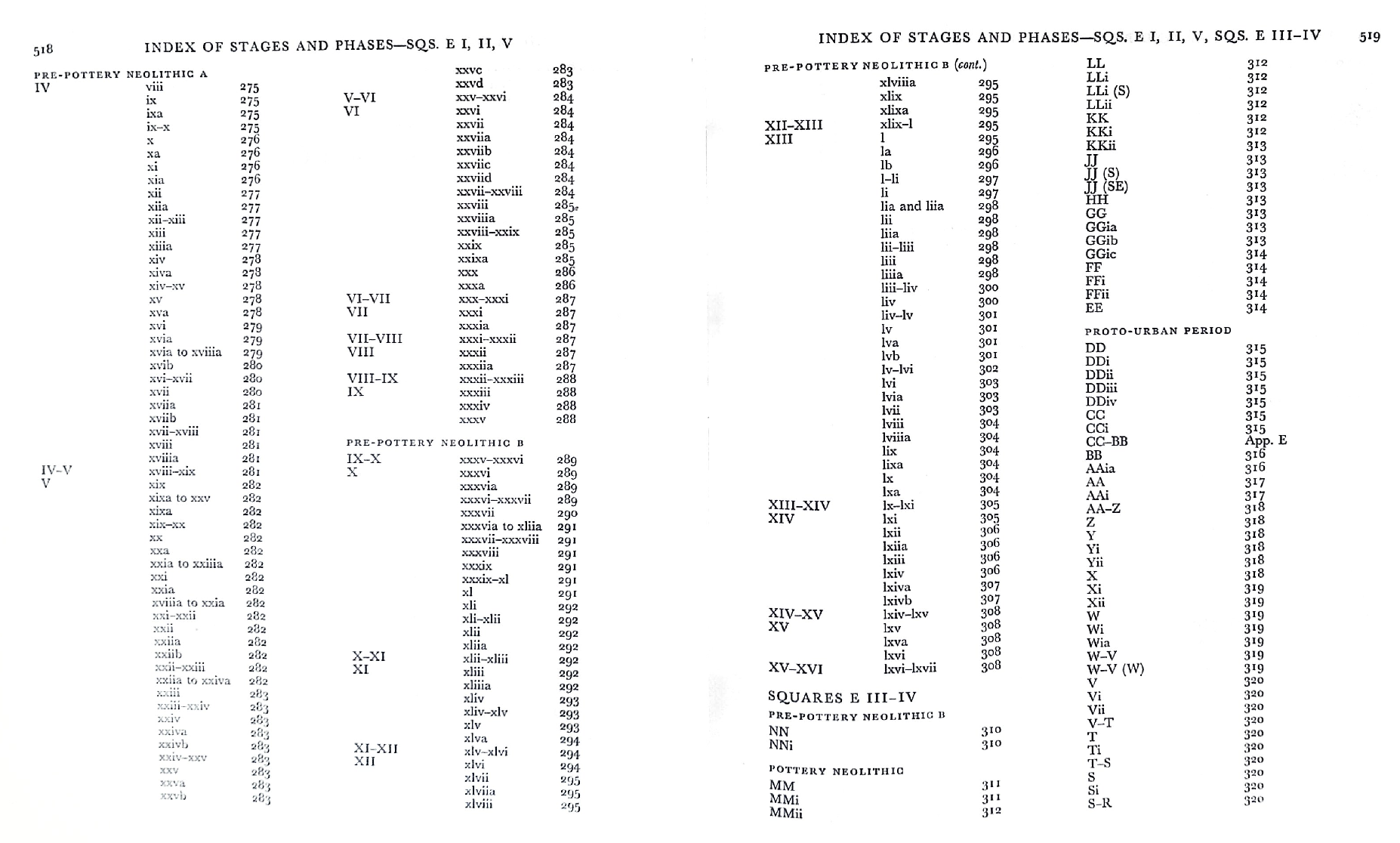
- from Kenyon (1981:3-4)
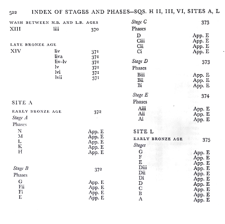
Each site is recorded separately, for only a stratigraphical link could prove the relationship of phases in different sites. In each site the deposits as recorded in the field are linked into phases by relation to structures, starting with i at the bottom. Normally, the construction levels, floor levels, and make-up and contents of walls are numbered, e.g. M I. xiv, though it is of course recognized that such levels probably contain mainly derived material. Occupation deposits would be numbered xiv a, with possibly xiv b as well, etc. Material from these deposits is thus more certainly contemporary with the structures. Very slight alterations in plan or structure may be numbered, e.g. xiv c, but normally an appreciable alteration would be called, e.g., phase xv. Usually between building phases there is a layer of collapse debris, which is numbered, e.g. M I. xiv-xv. It may contain material belonging to the last occupation of the structure, but could include objects dropped by later inhabitants tidying up the site, and could also include much earlier objects incorporated in bricks forming part of the collapse. The number of phases in most sites may seem large, but it must be remembered that when a wall has been reconstructed from a low level, a very considerable collapse of that building is indicated.
These structural phases are in each site grouped into Stages, indicating a main alteration in plan. Usually a new Stage is given when there is a complete break in plan. Some of the Stages cover a large number of phases, in which one building continues throughout though the others may change; an example is in E I, II, V, phases ix to xiv, where building E 3 continues throughout.
These Stages likewise cannot be applied from site to site. What possible connections there are are discussed in Jericho IV. The only exception to this is Trench I, and Squares F I, D I, and D II, where the phases in the different areas can be linked by their relationship to the defenses and in part by direct connections.
The only exception to this method of numbering the phases is Squares L I–IV. The pottery from the upper levels of this site was partly published by Professor J. B. Hennessy, at a time when it was still classified under the working annotations with A at the top, and so on downward in letters. It was felt that it would cause confusion to introduce new designations, and those used by Professor Hennessy, from Q up to A, have been retained. Some further excavations in this area were carried out after the end of the main excavations, and this system has been retained, back to Z, followed by AA, BB, as late as NN.
Incidentally, all sites were in origin sorted under letters, though normally with A at the bottom since the site had been excavated to bedrock. Museums and other collections where the material is deposited have been provided with correlation lists between the notations with which the object is marked and published designations, and also with the field notebook numbers.
The position of the excavation areas is shown on fig. 1. Since the areas were selected without strict reference to the main grid plan, which would in any case have been difficult, measurements are related only to the original excavations. In some cases, a key plan shows the discrepancies that arose in the various areas.
Fig. 1Composite sketch plan of excavations 1907–1958
Click on image to open in a new tab
Kenyon (1981 v.3a)
Figure 3Plan of Jericho
Click on image to open in a new tab
Kenyon (1957)
- Fig. 2 Map of coseismic
effects at Tell es-Sultan between 7,500 and 6,000 B.C. from Alfonsi et al. (2012)
Figure 2
Map of coseismic effects at Tell es-Sultan between 7,500 and 6,000 B.C. (Pre–Pottery Neolithic B). The locations of the effects are marked by numbers (descriptions as in Table 2). Original plan of the Tell modified from Kenyon (1981)
Alfonsi et al. (2012) - Fig. 2 Map of coseismic
effects in Zone A at Tell es-Sultan between 7,500 and 6,000 B.C. from Alfonsi et al. (2012)
Figure 2
Map of coseismic effects at Tell es-Sultan Zone A between 7,500 and 6,000 B.C. (Pre–Pottery Neolithic B). The locations of the effects are marked by numbers (descriptions as in Table 2). Original plan of the Tell modified from Kenyon (1981)
Alfonsi et al. (2012) - Fig. 2 Map of coseismic
effects in Zone B at Tell es-Sultan between 7,500 and 6,000 B.C. from Alfonsi et al. (2012)
Figure 2
Map of coseismic effects at Tell es-Sultan Zone B between 7,500 and 6,000 B.C. (Pre–Pottery Neolithic B). The locations of the effects are marked by numbers (descriptions as in Table 2). Original plan of the Tell modified from Kenyon (1981)
Alfonsi et al. (2012) - Fig. 2 Map of coseismic
effects in Entire Tell at Tell es-Sultan between 7,500 and 6,000 B.C. from Alfonsi et al. (2012)
Figure 2
Map of coseismic effects at Tell es-Sultan (Entire Tell) between 7,500 and 6,000 B.C. (Pre–Pottery Neolithic B). The locations of the effects are marked by numbers (descriptions as in Table 2). Original plan of the Tell modified from Kenyon (1981)
Alfonsi et al. (2012) - Fig. 2 Legend for Map
of coseismic effects at Tell es-Sultan between 7,500 and 6,000 B.C. from Alfonsi et al. (2012)
Figure 2
Legend for Map of coseismic effects at Tell es-Sultan between 7,500 and 6,000 B.C. (Pre–Pottery Neolithic B). The locations of the effects are marked by numbers (descriptions as in Table 2). Original plan of the Tell modified from Kenyon (1981)
Alfonsi et al. (2012)


- Fig. 4 Archaeoseismic
stratigraphic sections from Alfonsi et al. (2012)
Figure 4
Archaeoseismic stratigraphic sections modified from Garstang and Garstang (1948) and Kenyon (1981). Dashed squares in Garstang’s section are the approximate projections of Kenyon’s excavations both from zone A (logs in the inset) and zone B. The time— space relations between the layers and the observed coseismic effects (point numbers as in Figure 2 and Table 2) are illustrated. Horizons of the seismic shaking events recognized within the Pre-Pottery Neolithic B period are marked by stars.
Alfonsi et al. (2012)
- from Kenyon (1981:3-4)
Each site is recorded separately, for only a stratigraphical link could prove the relationship of phases in different sites. In each site the deposits as recorded in the field are linked into phases by relation to structures, starting with i at the bottom. Normally, the construction levels, floor levels, and make-up and contents of walls are numbered, e.g. M I. xiv, though it is of course recognized that such levels probably contain mainly derived material. Occupation deposits would be numbered xiv a, with possibly xiv b as well, etc. Material from these deposits is thus more certainly contemporary with the structures. Very slight alterations in plan or structure may be numbered, e.g. xiv c, but normally an appreciable alteration would be called, e.g., phase xv. Usually between building phases there is a layer of collapse debris, which is numbered, e.g. M I. xiv-xv. It may contain material belonging to the last occupation of the structure, but could include objects dropped by later inhabitants tidying up the site, and could also include much earlier objects incorporated in bricks forming part of the collapse. The number of phases in most sites may seem large, but it must be remembered that when a wall has been reconstructed from a low level, a very considerable collapse of that building is indicated.
These structural phases are in each site grouped into Stages, indicating a main alteration in plan. Usually a new Stage is given when there is a complete break in plan. Some of the Stages cover a large number of phases, in which one building continues throughout though the others may change; an example is in E I, II, V, phases ix to xiv, where building E 3 continues throughout.
These Stages likewise cannot be applied from site to site. What possible connections there are are discussed in Jericho IV. The only exception to this is Trench I, and Squares F I, D I, and D II, where the phases in the different areas can be linked by their relationship to the defenses and in part by direct connections.
The only exception to this method of numbering the phases is Squares L I–IV. The pottery from the upper levels of this site was partly published by Professor J. B. Hennessy, at a time when it was still classified under the working annotations with A at the top, and so on downward in letters. It was felt that it would cause confusion to introduce new designations, and those used by Professor Hennessy, from Q up to A, have been retained. Some further excavations in this area were carried out after the end of the main excavations, and this system has been retained, back to Z, followed by AA, BB, as late as NN.
Incidentally, all sites were in origin sorted under letters, though normally with A at the bottom since the site had been excavated to bedrock. Museums and other collections where the material is deposited have been provided with correlation lists between the notations with which the object is marked and published designations, and also with the field notebook numbers.
The position of the excavation areas is shown on fig. 1. Since the areas were selected without strict reference to the main grid plan, which would in any case have been difficult, measurements are related only to the original excavations. In some cases, a key plan shows the discrepancies that arose in the various areas.
Fig. 1Composite sketch plan of excavations 1907–1958
Click on image to open in a new tab
Kenyon (1981 v.3a)
Figure 3Plan of Jericho
Click on image to open in a new tab
Kenyon (1957)
- Fig. 2 Map of coseismic
effects at Tell es-Sultan between 7,500 and 6,000 B.C. from Alfonsi et al. (2012)
Figure 2
Map of coseismic effects at Tell es-Sultan between 7,500 and 6,000 B.C. (Pre–Pottery Neolithic B). The locations of the effects are marked by numbers (descriptions as in Table 2). Original plan of the Tell modified from Kenyon (1981)
Alfonsi et al. (2012) - Fig. 2 Map of coseismic
effects in Zone A at Tell es-Sultan between 7,500 and 6,000 B.C. from Alfonsi et al. (2012)
Figure 2
Map of coseismic effects at Tell es-Sultan Zone A between 7,500 and 6,000 B.C. (Pre–Pottery Neolithic B). The locations of the effects are marked by numbers (descriptions as in Table 2). Original plan of the Tell modified from Kenyon (1981)
Alfonsi et al. (2012) - Fig. 2 Map of coseismic
effects in Zone B at Tell es-Sultan between 7,500 and 6,000 B.C. from Alfonsi et al. (2012)
Figure 2
Map of coseismic effects at Tell es-Sultan Zone B between 7,500 and 6,000 B.C. (Pre–Pottery Neolithic B). The locations of the effects are marked by numbers (descriptions as in Table 2). Original plan of the Tell modified from Kenyon (1981)
Alfonsi et al. (2012) - Fig. 2 Map of coseismic
effects in Entire Tell at Tell es-Sultan between 7,500 and 6,000 B.C. from Alfonsi et al. (2012)
Figure 2
Map of coseismic effects at Tell es-Sultan (Entire Tell) between 7,500 and 6,000 B.C. (Pre–Pottery Neolithic B). The locations of the effects are marked by numbers (descriptions as in Table 2). Original plan of the Tell modified from Kenyon (1981)
Alfonsi et al. (2012) - Fig. 2 Legend for Map
of coseismic effects at Tell es-Sultan between 7,500 and 6,000 B.C. from Alfonsi et al. (2012)
Figure 2
Legend for Map of coseismic effects at Tell es-Sultan between 7,500 and 6,000 B.C. (Pre–Pottery Neolithic B). The locations of the effects are marked by numbers (descriptions as in Table 2). Original plan of the Tell modified from Kenyon (1981)
Alfonsi et al. (2012)
- Fig. 2 Map of coseismic
effects at Tell es-Sultan between 7,500 and 6,000 B.C. from Alfonsi et al. (2012)
Figure 2
Map of coseismic effects at Tell es-Sultan between 7,500 and 6,000 B.C. (Pre–Pottery Neolithic B). The locations of the effects are marked by numbers (descriptions as in Table 2). Original plan of the Tell modified from Kenyon (1981)
Alfonsi et al. (2012) - Fig. 2 Map of coseismic
effects in Zone A at Tell es-Sultan between 7,500 and 6,000 B.C. from Alfonsi et al. (2012)
Figure 2
Map of coseismic effects at Tell es-Sultan Zone A between 7,500 and 6,000 B.C. (Pre–Pottery Neolithic B). The locations of the effects are marked by numbers (descriptions as in Table 2). Original plan of the Tell modified from Kenyon (1981)
Alfonsi et al. (2012) - Fig. 2 Map of coseismic
effects in Zone B at Tell es-Sultan between 7,500 and 6,000 B.C. from Alfonsi et al. (2012)
Figure 2
Map of coseismic effects at Tell es-Sultan Zone B between 7,500 and 6,000 B.C. (Pre–Pottery Neolithic B). The locations of the effects are marked by numbers (descriptions as in Table 2). Original plan of the Tell modified from Kenyon (1981)
Alfonsi et al. (2012) - Fig. 2 Map of coseismic
effects in Entire Tell at Tell es-Sultan between 7,500 and 6,000 B.C. from Alfonsi et al. (2012)
Figure 2
Map of coseismic effects at Tell es-Sultan (Entire Tell) between 7,500 and 6,000 B.C. (Pre–Pottery Neolithic B). The locations of the effects are marked by numbers (descriptions as in Table 2). Original plan of the Tell modified from Kenyon (1981)
Alfonsi et al. (2012) - Fig. 2 Legend for Map
of coseismic effects at Tell es-Sultan between 7,500 and 6,000 B.C. from Alfonsi et al. (2012)
Figure 2
Legend for Map of coseismic effects at Tell es-Sultan between 7,500 and 6,000 B.C. (Pre–Pottery Neolithic B). The locations of the effects are marked by numbers (descriptions as in Table 2). Original plan of the Tell modified from Kenyon (1981)
Alfonsi et al. (2012)
- Fig. 4 Archaeoseismic
stratigraphic sections from Alfonsi et al. (2012)
Figure 4
Archaeoseismic stratigraphic sections modified from Garstang and Garstang (1948) and Kenyon (1981). Dashed squares in Garstang’s section are the approximate projections of Kenyon’s excavations both from zone A (logs in the inset) and zone B. The time— space relations between the layers and the observed coseismic effects (point numbers as in Figure 2 and Table 2) are illustrated. Horizons of the seismic shaking events recognized within the Pre-Pottery Neolithic B period are marked by stars.
Alfonsi et al. (2012)
- Fig. 1 Oblique Aerial View
of Tell es-Sultan from Nigro (2016)
 Figure 1
General view of the site of Tell es-Sultan, from the south.
Photograph and Image by Lorenzo Nigro, © University of Rome “La Sapienza” ROSAPAJ
Nigro (2016) - Fig. 3a Coseismic Effects
Photo from Alfonsi et al. (2012)
 Figure 3a
Photos illustrating some of the effects caused by seismic shaking at Tell es-Sultan (numbered as in Figure 2 and Table 2).
(a) Black arrows point to fractures crossing the floor and the perimeter wall of Pre-Pottery Neolithic B houses. Original picture from Kenyon (1981).
Alfonsi et al. (2012) - Fig. 3b Coseismic Effects
Photo from Alfonsi et al. (2012)
 Figure 3b
Photos illustrating some of the effects caused by seismic shaking at Tell es-Sultan (numbered as in Figure 2 and Table 2).
(b) Human skeleton found under a collapsed wall. Original picture from Kenyon (1981).
Alfonsi et al. (2012) - Fig. 3c Coseismic Effects
Photo from Alfonsi et al. (2012)
 Figure 3c
Photos illustrating some of the effects caused by seismic shaking at Tell es-Sultan (numbered as in Figure 2 and Table 2).
(c) View from the top of a complete northward collapse of a wall, giving the illusion of a pavement. Original picture from Kenyon (1981).
Alfonsi et al. (2012) - Fig. 3d Coseismic Effects
Photo from Alfonsi et al. (2012)
 Figure 3d
Photos illustrating some of the effects caused by seismic shaking at Tell es-Sultan (numbered as in Figure 2 and Table 2).
(d) East view of the Garstang excavation. Visible in the foreground is a fracture crossing the floor and the adjacent wall affecting layer X, dated as the latest stage of Pre–Pottery Neolithic B. Original picture from Garstang and Garstang (1948).
Alfonsi et al. (2012) - Fig. 3e Coseismic Effects
Photo from Alfonsi et al. (2012)
 Figure 3e
Photos illustrating some of the effects caused by seismic shaking at Tell es-Sultan (numbered as in Figure 2 and Table 2).
(e) The Garstang excavation as appears today (same shot position). Original picture from Garstang and Garstang (1948).
Alfonsi et al. (2012) - Fig. 3f Coseismic Effects
Photo from Alfonsi et al. (2012)
 Figure 3f
Photos illustrating some of the effects caused by seismic shaking at Tell es-Sultan (numbered as in Figure 2 and Table 2).
(f) Black arrows point to a fracture crossing a pavement and a skeleton. An apparent displacement of skull versus body is observable. The white circle inscribes the possible correspondence between the cervical and neck bones (black dots). Original picture from Garstang and Garstang (1948).
Alfonsi et al. (2012)
- from Kenyon (1981:3-4)
Each site is recorded separately, for only a stratigraphical link could prove the relationship of phases in different sites. In each site the deposits as recorded in the field are linked into phases by relation to structures, starting with i at the bottom. Normally, the construction levels, floor levels, and make-up and contents of walls are numbered, e.g. M I. xiv, though it is of course recognized that such levels probably contain mainly derived material. Occupation deposits would be numbered xiv a, with possibly xiv b as well, etc. Material from these deposits is thus more certainly contemporary with the structures. Very slight alterations in plan or structure may be numbered, e.g. xiv c, but normally an appreciable alteration would be called, e.g., phase xv. Usually between building phases there is a layer of collapse debris, which is numbered, e.g. M I. xiv-xv. It may contain material belonging to the last occupation of the structure, but could include objects dropped by later inhabitants tidying up the site, and could also include much earlier objects incorporated in bricks forming part of the collapse. The number of phases in most sites may seem large, but it must be remembered that when a wall has been reconstructed from a low level, a very considerable collapse of that building is indicated.
These structural phases are in each site grouped into Stages, indicating a main alteration in plan. Usually a new Stage is given when there is a complete break in plan. Some of the Stages cover a large number of phases, in which one building continues throughout though the others may change; an example is in E I, II, V, phases ix to xiv, where building E 3 continues throughout.
These Stages likewise cannot be applied from site to site. What possible connections there are are discussed in Jericho IV. The only exception to this is Trench I, and Squares F I, D I, and D II, where the phases in the different areas can be linked by their relationship to the defenses and in part by direct connections.
The only exception to this method of numbering the phases is Squares L I–IV. The pottery from the upper levels of this site was partly published by Professor J. B. Hennessy, at a time when it was still classified under the working annotations with A at the top, and so on downward in letters. It was felt that it would cause confusion to introduce new designations, and those used by Professor Hennessy, from Q up to A, have been retained. Some further excavations in this area were carried out after the end of the main excavations, and this system has been retained, back to Z, followed by AA, BB, as late as NN.
Incidentally, all sites were in origin sorted under letters, though normally with A at the bottom since the site had been excavated to bedrock. Museums and other collections where the material is deposited have been provided with correlation lists between the notations with which the object is marked and published designations, and also with the field notebook numbers.
The position of the excavation areas is shown on fig. 1. Since the areas were selected without strict reference to the main grid plan, which would in any case have been difficult, measurements are related only to the original excavations. In some cases, a key plan shows the discrepancies that arose in the various areas.
Fig. 1Composite sketch plan of excavations 1907–1958
Click on image to open in a new tab
Kenyon (1981 v.3a)
Figure 3Plan of Jericho
Click on image to open in a new tab
Kenyon (1957)
- Fig. 2 Map of coseismic
effects at Tell es-Sultan between 7,500 and 6,000 B.C. from Alfonsi et al. (2012)
Figure 2
Map of coseismic effects at Tell es-Sultan between 7,500 and 6,000 B.C. (Pre–Pottery Neolithic B). The locations of the effects are marked by numbers (descriptions as in Table 2). Original plan of the Tell modified from Kenyon (1981)
Alfonsi et al. (2012) - Fig. 2 Map of coseismic
effects in Zone A at Tell es-Sultan between 7,500 and 6,000 B.C. from Alfonsi et al. (2012)
Figure 2
Map of coseismic effects at Tell es-Sultan Zone A between 7,500 and 6,000 B.C. (Pre–Pottery Neolithic B). The locations of the effects are marked by numbers (descriptions as in Table 2). Original plan of the Tell modified from Kenyon (1981)
Alfonsi et al. (2012) - Fig. 2 Map of coseismic
effects in Zone B at Tell es-Sultan between 7,500 and 6,000 B.C. from Alfonsi et al. (2012)
Figure 2
Map of coseismic effects at Tell es-Sultan Zone B between 7,500 and 6,000 B.C. (Pre–Pottery Neolithic B). The locations of the effects are marked by numbers (descriptions as in Table 2). Original plan of the Tell modified from Kenyon (1981)
Alfonsi et al. (2012) - Fig. 2 Map of coseismic
effects in Entire Tell at Tell es-Sultan between 7,500 and 6,000 B.C. from Alfonsi et al. (2012)
Figure 2
Map of coseismic effects at Tell es-Sultan (Entire Tell) between 7,500 and 6,000 B.C. (Pre–Pottery Neolithic B). The locations of the effects are marked by numbers (descriptions as in Table 2). Original plan of the Tell modified from Kenyon (1981)
Alfonsi et al. (2012) - Fig. 2 Legend for Map
of coseismic effects at Tell es-Sultan between 7,500 and 6,000 B.C. from Alfonsi et al. (2012)
Figure 2
Legend for Map of coseismic effects at Tell es-Sultan between 7,500 and 6,000 B.C. (Pre–Pottery Neolithic B). The locations of the effects are marked by numbers (descriptions as in Table 2). Original plan of the Tell modified from Kenyon (1981)
Alfonsi et al. (2012)
- Fig. 2 Map of coseismic
effects at Tell es-Sultan between 7,500 and 6,000 B.C. from Alfonsi et al. (2012)
Figure 2
Map of coseismic effects at Tell es-Sultan between 7,500 and 6,000 B.C. (Pre–Pottery Neolithic B). The locations of the effects are marked by numbers (descriptions as in Table 2). Original plan of the Tell modified from Kenyon (1981)
Alfonsi et al. (2012) - Fig. 2 Map of coseismic
effects in Zone A at Tell es-Sultan between 7,500 and 6,000 B.C. from Alfonsi et al. (2012)
Figure 2
Map of coseismic effects at Tell es-Sultan Zone A between 7,500 and 6,000 B.C. (Pre–Pottery Neolithic B). The locations of the effects are marked by numbers (descriptions as in Table 2). Original plan of the Tell modified from Kenyon (1981)
Alfonsi et al. (2012) - Fig. 2 Map of coseismic
effects in Zone B at Tell es-Sultan between 7,500 and 6,000 B.C. from Alfonsi et al. (2012)
Figure 2
Map of coseismic effects at Tell es-Sultan Zone B between 7,500 and 6,000 B.C. (Pre–Pottery Neolithic B). The locations of the effects are marked by numbers (descriptions as in Table 2). Original plan of the Tell modified from Kenyon (1981)
Alfonsi et al. (2012) - Fig. 2 Map of coseismic
effects in Entire Tell at Tell es-Sultan between 7,500 and 6,000 B.C. from Alfonsi et al. (2012)
Figure 2
Map of coseismic effects at Tell es-Sultan (Entire Tell) between 7,500 and 6,000 B.C. (Pre–Pottery Neolithic B). The locations of the effects are marked by numbers (descriptions as in Table 2). Original plan of the Tell modified from Kenyon (1981)
Alfonsi et al. (2012) - Fig. 2 Legend for Map
of coseismic effects at Tell es-Sultan between 7,500 and 6,000 B.C. from Alfonsi et al. (2012)
Figure 2
Legend for Map of coseismic effects at Tell es-Sultan between 7,500 and 6,000 B.C. (Pre–Pottery Neolithic B). The locations of the effects are marked by numbers (descriptions as in Table 2). Original plan of the Tell modified from Kenyon (1981)
Alfonsi et al. (2012)
- Fig. 4 Archaeoseismic
stratigraphic sections from Alfonsi et al. (2012)
Figure 4
Archaeoseismic stratigraphic sections modified from Garstang and Garstang (1948) and Kenyon (1981). Dashed squares in Garstang’s section are the approximate projections of Kenyon’s excavations both from zone A (logs in the inset) and zone B. The time— space relations between the layers and the observed coseismic effects (point numbers as in Figure 2 and Table 2) are illustrated. Horizons of the seismic shaking events recognized within the Pre-Pottery Neolithic B period are marked by stars.
Alfonsi et al. (2012)
- Fig. 4 Archaeoseismic
stratigraphic sections from Alfonsi et al. (2012)
Figure 4
Archaeoseismic stratigraphic sections modified from Garstang and Garstang (1948) and Kenyon (1981). Dashed squares in Garstang’s section are the approximate projections of Kenyon’s excavations both from zone A (logs in the inset) and zone B. The time— space relations between the layers and the observed coseismic effects (point numbers as in Figure 2 and Table 2) are illustrated. Horizons of the seismic shaking events recognized within the Pre-Pottery Neolithic B period are marked by stars.
Alfonsi et al. (2012)
- Fig. 1 Oblique Aerial View
of Tell es-Sultan from Nigro (2016)
Figure 1
General view of the site of Tell es-Sultan, from the south.
Photograph and Image by Lorenzo Nigro, © University of Rome “La Sapienza” ROSAPAJ
Nigro (2016) - Fig. 3a Coseismic Effects
Photo from Alfonsi et al. (2012)
Figure 3a
Photos illustrating some of the effects caused by seismic shaking at Tell es-Sultan (numbered as in Figure 2 and Table 2).
(a) Black arrows point to fractures crossing the floor and the perimeter wall of Pre-Pottery Neolithic B houses. Original picture from Kenyon (1981).
Alfonsi et al. (2012) - Fig. 3b Coseismic Effects
Photo from Alfonsi et al. (2012)
Figure 3b
Photos illustrating some of the effects caused by seismic shaking at Tell es-Sultan (numbered as in Figure 2 and Table 2).
(b) Human skeleton found under a collapsed wall. Original picture from Kenyon (1981).
Alfonsi et al. (2012) - Fig. 3c Coseismic Effects
Photo from Alfonsi et al. (2012)
Figure 3c
Photos illustrating some of the effects caused by seismic shaking at Tell es-Sultan (numbered as in Figure 2 and Table 2).
(c) View from the top of a complete northward collapse of a wall, giving the illusion of a pavement. Original picture from Kenyon (1981).
Alfonsi et al. (2012) - Fig. 3d Coseismic Effects
Photo from Alfonsi et al. (2012)
Figure 3d
Photos illustrating some of the effects caused by seismic shaking at Tell es-Sultan (numbered as in Figure 2 and Table 2).
(d) East view of the Garstang excavation. Visible in the foreground is a fracture crossing the floor and the adjacent wall affecting layer X, dated as the latest stage of Pre–Pottery Neolithic B. Original picture from Garstang and Garstang (1948).
Alfonsi et al. (2012) - Fig. 3e Coseismic Effects
Photo from Alfonsi et al. (2012)
Figure 3e
Photos illustrating some of the effects caused by seismic shaking at Tell es-Sultan (numbered as in Figure 2 and Table 2).
(e) The Garstang excavation as appears today (same shot position). Original picture from Garstang and Garstang (1948).
Alfonsi et al. (2012) - Fig. 3f Coseismic Effects
Photo from Alfonsi et al. (2012)
Figure 3f
Photos illustrating some of the effects caused by seismic shaking at Tell es-Sultan (numbered as in Figure 2 and Table 2).
(f) Black arrows point to a fracture crossing a pavement and a skeleton. An apparent displacement of skull versus body is observable. The white circle inscribes the possible correspondence between the cervical and neck bones (black dots). Original picture from Garstang and Garstang (1948).
Alfonsi et al. (2012)
- from Kenyon (1981:3-4)
Each site is recorded separately, for only a stratigraphical link could prove the relationship of phases in different sites. In each site the deposits as recorded in the field are linked into phases by relation to structures, starting with i at the bottom. Normally, the construction levels, floor levels, and make-up and contents of walls are numbered, e.g. M I. xiv, though it is of course recognized that such levels probably contain mainly derived material. Occupation deposits would be numbered xiv a, with possibly xiv b as well, etc. Material from these deposits is thus more certainly contemporary with the structures. Very slight alterations in plan or structure may be numbered, e.g. xiv c, but normally an appreciable alteration would be called, e.g., phase xv. Usually between building phases there is a layer of collapse debris, which is numbered, e.g. M I. xiv-xv. It may contain material belonging to the last occupation of the structure, but could include objects dropped by later inhabitants tidying up the site, and could also include much earlier objects incorporated in bricks forming part of the collapse. The number of phases in most sites may seem large, but it must be remembered that when a wall has been reconstructed from a low level, a very considerable collapse of that building is indicated.
These structural phases are in each site grouped into Stages, indicating a main alteration in plan. Usually a new Stage is given when there is a complete break in plan. Some of the Stages cover a large number of phases, in which one building continues throughout though the others may change; an example is in E I, II, V, phases ix to xiv, where building E 3 continues throughout.
These Stages likewise cannot be applied from site to site. What possible connections there are are discussed in Jericho IV. The only exception to this is Trench I, and Squares F I, D I, and D II, where the phases in the different areas can be linked by their relationship to the defenses and in part by direct connections.
The only exception to this method of numbering the phases is Squares L I–IV. The pottery from the upper levels of this site was partly published by Professor J. B. Hennessy, at a time when it was still classified under the working annotations with A at the top, and so on downward in letters. It was felt that it would cause confusion to introduce new designations, and those used by Professor Hennessy, from Q up to A, have been retained. Some further excavations in this area were carried out after the end of the main excavations, and this system has been retained, back to Z, followed by AA, BB, as late as NN.
Incidentally, all sites were in origin sorted under letters, though normally with A at the bottom since the site had been excavated to bedrock. Museums and other collections where the material is deposited have been provided with correlation lists between the notations with which the object is marked and published designations, and also with the field notebook numbers.
The position of the excavation areas is shown on fig. 1. Since the areas were selected without strict reference to the main grid plan, which would in any case have been difficult, measurements are related only to the original excavations. In some cases, a key plan shows the discrepancies that arose in the various areas.
Fig. 1Composite sketch plan of excavations 1907–1958
Click on image to open in a new tab
Kenyon (1981 v.3a)
Figure 3Plan of Jericho
Click on image to open in a new tab
Kenyon (1957)
- from Alfonsi et al. (2012:Table 1)
- Neither Ben-Menahem (1991) nor Ambraseys (2009) write about this earthquake
- from Kenyon (1981:3-4)
Each site is recorded separately, for only a stratigraphical link could prove the relationship of phases in different sites. In each site the deposits as recorded in the field are linked into phases by relation to structures, starting with i at the bottom. Normally, the construction levels, floor levels, and make-up and contents of walls are numbered, e.g. M I. xiv, though it is of course recognized that such levels probably contain mainly derived material. Occupation deposits would be numbered xiv a, with possibly xiv b as well, etc. Material from these deposits is thus more certainly contemporary with the structures. Very slight alterations in plan or structure may be numbered, e.g. xiv c, but normally an appreciable alteration would be called, e.g., phase xv. Usually between building phases there is a layer of collapse debris, which is numbered, e.g. M I. xiv-xv. It may contain material belonging to the last occupation of the structure, but could include objects dropped by later inhabitants tidying up the site, and could also include much earlier objects incorporated in bricks forming part of the collapse. The number of phases in most sites may seem large, but it must be remembered that when a wall has been reconstructed from a low level, a very considerable collapse of that building is indicated.
These structural phases are in each site grouped into Stages, indicating a main alteration in plan. Usually a new Stage is given when there is a complete break in plan. Some of the Stages cover a large number of phases, in which one building continues throughout though the others may change; an example is in E I, II, V, phases ix to xiv, where building E 3 continues throughout.
These Stages likewise cannot be applied from site to site. What possible connections there are are discussed in Jericho IV. The only exception to this is Trench I, and Squares F I, D I, and D II, where the phases in the different areas can be linked by their relationship to the defenses and in part by direct connections.
The only exception to this method of numbering the phases is Squares L I–IV. The pottery from the upper levels of this site was partly published by Professor J. B. Hennessy, at a time when it was still classified under the working annotations with A at the top, and so on downward in letters. It was felt that it would cause confusion to introduce new designations, and those used by Professor Hennessy, from Q up to A, have been retained. Some further excavations in this area were carried out after the end of the main excavations, and this system has been retained, back to Z, followed by AA, BB, as late as NN.
Incidentally, all sites were in origin sorted under letters, though normally with A at the bottom since the site had been excavated to bedrock. Museums and other collections where the material is deposited have been provided with correlation lists between the notations with which the object is marked and published designations, and also with the field notebook numbers.
The position of the excavation areas is shown on fig. 1. Since the areas were selected without strict reference to the main grid plan, which would in any case have been difficult, measurements are related only to the original excavations. In some cases, a key plan shows the discrepancies that arose in the various areas.
Fig. 1Composite sketch plan of excavations 1907–1958
Click on image to open in a new tab
Kenyon (1981 v.3a)
Figure 3Plan of Jericho
Click on image to open in a new tab
Kenyon (1957)
- from Wood (1990a)
The site has been excavated several times in this century. Based on the conclusion of the most recent excavator, British archaeologist Kathleen Kenyon, most historians and Bible scholars would answer with a resounding "No, certainly not! There was no city there at the time Joshua supposedly conquered it."
Some 30 years after her excavation of the site – indeed, 12 years after Kenyon’s death – the detailed evidence has now become available in the final report. So it is time for a new look.
Ancient Jericho is located at Tell es-Sultan, next to a copious spring on the western edge of the Jordan Valley, just north of the Dead Sea. The site’s excellent water supply and favorable climate (especially in winter) have made it a desirable place to live from the very beginning of settled habitation. A Neolithic settlement at the site goes back to about 8000 B.C.E.,* thus giving Jericho the distinction of being the world’s oldest city. At 670 feet below sea level, it is also the lowest city in the world.
The site is strategically located. From Jericho one has access to the heartland of Canaan.1 Any military force attempting to penetrate the central hill country from the east would, by necessity, first have to capture Jericho. And that is exactly what the Bible (Joshua 3:16) says the Israelites did.
After wandering in the Sinai desert for 40 years, the Israelites prepared to cross the Jordan River and enter the Promised Land from opposite Jericho. Before making the crossing, however, Joshua, the Israelite commander, dispatched two spies to reconnoiter the city. Narrowly escaping capture, the spies brought back valuable intelligence collected from Rahab, a harlot who lived within the city wall. Although the Jordan was in flood at the time the Israelites crossed, the waters were miraculously stopped and the Israelites were able to cross "on dry ground." They then marched around the heavily fortified city daily for seven days. On the seventh day, to the blast of the ram’s horn, the walls came tumbling down. The Israelites rushed into the city and put it to the torch.
Because of its importance in Biblical history, Jericho was the second site in the Holy Land, Jerusalem being the first, to feel the excavators’ picks. The first documented excavation was undertaken in 1867 and 1868 by the famous British engineer Charles Warren.2 Jericho was one of nine tells, or mounds, he excavated in the Jordan Valley in an effort to determine if they were natural or artificial. He dug six vertical shafts and three trenches at Jericho. Based on his findings, Warren was able to provide an answer to what had been a serious question until that time:
As a general result on the completion of these excavations it may be said for a certainty that these mounds are artificial throughout, and that they probably are the remains of ancient castles.3He was wrong about the castles, but he was certainly right that the mounds were ancient ruins.
The first major excavation at Jericho was conducted by an Austro-German expedition under the direction of Ernst Sellin and Carl Watzinger from 1907 to 1909 and again in 1911.4 This was before pottery chronology was well developed, so their dating was far off the mark. Watzinger later revised the chronology, however,5 and their carefully drawn plans (see below) and sections can still provide valuable information.6 For example, they traced the Middle Bronze revetment wall around three-quarters of the base of the tell, although at the time they did not fully understand the complexities of the Middle Bronze fortification system. It was only when Kathleen Kenyon excavated the site in the 1950s that the nature of the revetment wall was clarified, as we will soon see.
After his redating, Watzinger concluded that Jericho was unoccupied (and therefore obviously unfortified) during the Late Bronze period (c. 1550-1200 B.C.E.), the time when the Israelites first appeared in Canaan.
John Garstang, a British archaeologist, questioned these results and mounted an expedition of his own to gather further evidence regarding the date of the fortifications at Jericho.7 Garstang was the first investigator to use modern methods at the site, although his work was still crude by today’s standards. He dug from 1930 to 1936 and promptly published his findings in a series of preliminary reports.8 Although the Second World War prevented Garstang from publishing a final report on his work, after the war, in collaboration with his son, he published a popular account that summarized his final views on Jericho.9
Garstang excavated a collapsed double city wall on the summit of the tell that he dated to the late-15th to early 14th-century B.C.E. (the Late Bronze Age). He also excavated a residential area on the southeast slope of the mound which he believed was part of the city fortified by the double wall. He designated this "City IV." It had been thoroughly destroyed in a violent conflagration.
Garstang concluded that City IV came to an end about 1400 B.C.E., based on pottery found in the destruction debris, on scarabs recovered from nearby tombs and on the absence of Mycenaean ware. He ascribed the destruction to invading Israelites. The matter seemed settled in Garstang’s mind:
In a word, in all material details and in date the fall of Jericho took place as described in the Biblical narrative. Our demonstration is limited, however, to material observations: the walls fell, shaken apparently by earthquake, and the city was destroyed by fire, about 1400 B.C. These are the basic facts resulting from our investigations. The link with Joshua and the Israelites is only circumstantial but it seems to be solid and without a flaw."10But was the matter really settled? Hardly. In reality, Garstang’s conclusions precipitated considerable controversy among his colleagues.11 After a few years, and further advances in the knowledge of Palestinian archaeology, Garstang asked an up-and-coming British archaeologist named Kathleen Kenyon to review and update his findings. Kenyon did so and came up with more or less the same conclusion Sellin and Watzinger had reached 25 years earlier: Jericho was destroyed at the end of the Middle Bronze Age in the mid-16th century B.C.E. and was unoccupied throughout the Late Bronze Age, except for a very small area occupied for a short time in the 14th century B.C.E.12 So much for progress in Palestinian archaeology!
As an outgrowth of questions raised in her critique, Kenyon headed up yet another campaign to the ruins at Tell es-Sultan. This one lasted from 1952 to 1958. Kenyon’s excavation ushered in a new era in Palestinian archaeology. She introduced rigorous stratigraphic excavation techniques entailing detailed analysis of soil and debris layers and careful recording of the sides of the excavation squares called balks.13 Kenyon concluded that her field work confirmed her earlier review of Garstang’s work. The double city wall Garstang associated with the Israelite invasion in about 1400 B.C.E. in fact dated to the Early Bronze Age some 1,000 years earlier. The destruction of Garstang’s City IV, which he had dated to about 1400 B.C.E., occurred, according to Kenyon, at the end of the Middle Bronze Age, about 1550 B.C.E.14
In short, there was no strongly fortified Late Bronze Age city at Jericho for Joshua to conquer. The archaeological evidence conflicted with the Biblical account – indeed, disproved it.
Based on Kenyon’s conclusions, Jericho has become the parade example of the difficulties encountered in attempting to correlate the findings of archaeology with the Biblical account of a military conquest of Canaan. Scholars by and large have written off the Biblical record as so much folklore and religious rhetoric. And this is where the matter has stood for the past 25 years.
Kenyon died in 1978 without living to see the final publication of her excavation of the tell. Her conclusions were reported only in a popular book published the year before she completed her fieldwork,15 in a series of preliminary reports16 and in scattered articles. The detailed evidence, however, was never supplied. This became available only in 1982 and 1983 when two volumes on pottery excavated from the tell were published.17 This, together with the stratigraphic data from the excavation, published in 1981,18 makes it possible to perform an independent assessment of Kenyon’s conclusions.
I first became interested in Jericho while working on my Ph.D. dissertation on Canaanite pottery of the Late Bronze Age. I would occasionally thumb through Garstang’s preliminary reports to see if there was anything of interest. I became intrigued by a considerable amount of what appeared to be Late Bronze I (c. 1550-1400 B.C.E.) pottery he had excavated. This was precisely the period Kenyon repeatedly said was absent at Jericho! Because of the lack of precision in Garstang’s field work and the rambling nature of his preliminary reports, it was not possible to gain a clear picture of the stratigraphic sequence at Jericho from Garstang’s work alone. Kenyon’s conclusions, on the other hand, could not be checked because her work remained unpublished.
After completing my dissertation in 1985, I decided to pursue the matter further, since by this time the Jericho reports were available.
There is little doubt that Kenyon was correct in dating the double wall on top of the tell to the Early Bronze Age. In this she was right and Garstang wrong. But there is a serious question about her dating of the destruction of the residential area of the final Bronze Age city (Garstang’s City IV) to the end of the Middle Bronze Age (c. 1550 B.C.E.). Here I believe Garstang was right after all!
Before explaining why Garstang’s date for the destruction of City IV – about c. 1400 B.C.E., in the Late Bronze Age – is to be preferred to Kenyon’s date at the end of the Middle Bronze Age, let me say a few words about Kenyon’s methodology.
As I have already observed, during her lifetime, Kenyon never published a definitive study of the pottery from the last phases of City IV, before its destruction. The final excavation reports published after her death reflect Kenyon’s meticulous field work and contain a complete and detailed presentation of her excavation results. But they merely present the raw data, with no analysis or comment. To understand how Kenyon reached her conclusion, we must piece together scattered statements in various writings. When we do this, it becomes clear that Kenyon based her opinion almost exclusively on the absence of pottery imported from Cyprus and common to the Late Bronze I period (c. 1550-1400 B.C.E.). This imported Cypriote ware had been previously found mainly in some Megiddo tomb groups, and Kenyon used this pottery to construct her ceramic typology for the Late Bronze I period.19 Although she also mentions certain local pottery types used in this period,20 it is obvious she paid little attention to these common domestic forms since they appear regularly in the final phases of City IV. That she did not focus more on the local pottery is especially strange because considerable stratified local daily-use pottery from the Late Bronze I period had been excavated and was available for her to work with even at the beginning of her excavation at Jericho. Instead, Kenyon chose to emphasize the imported wares in reaching her chronological conclusions. As a result, Kenyon reached the following determination: When the material is analyzed in the light of our present knowledge, it becomes clear that there is a complete gap both on the tell and in the tombs [found to the northwest of the tell] between c. 1560 B.C. and c. 1400 B.C.21 (From the period after 1400 B.C.E., she found a residence-type structure and associated outbuildings, which she dated to about 1325 B.C.E. After that, the site remained abandoned until about the 11th century B.C.E.)
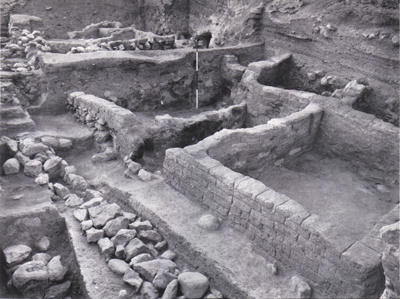
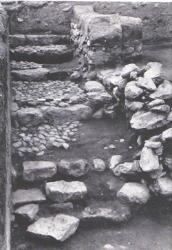
click on image to open in a new tab
Wood (1990a)
In other words, Kenyon’s analysis was based on what was not found at Jericho rather than what was found. According to Kenyon, City IV must have been destroyed at the end of the Middle Bronze Age (c. 1550 B.C.E.) because no imported Cypriote ware – diagnostic for the ensuing Late Bronze I period – was found at Jericho.
Dating habitation levels at Jericho on the absence of exotic imported wares – which were found primarily in tombs in large urban centers – is methodologically unsound and, indeed, unacceptable.
Kenyon drew her comparative material from large cities like Megiddo situated on major trade routes far from Jericho. Jericho, by contrast, is a small site22 well off the major trade routes of the day.
A careful examination of the Jericho excavation reports as a whole, moreover, makes it clear that both Garstang and Kenyon dug in a poor quarter of the city where they found only humble domestic dwellings. Kenyon writes of the final phase of City IV:
The picture given... is that of simple villagers. There is no suggestion at all of luxury.... It was quite probable that Jericho at this time was something of a backwater, away from the contacts with richer areas provided by the coastal route.23Why then would anyone expect to find exotic imported ceramics in this type of cultural milieu!
To make matters worse, Kenyon based her conclusions on a very limited excavation area – two 26-foot by 26-foot squares. An argument from silence is always problematic, but Kenyon’s argument is especially poorly founded. She based her dating on the fact that she failed to find expensive, imported pottery in a small excavation area in an impoverished part of a city located far from major trade routes!
Rather than unusual imported wares, attention should be given to the ordinary domestic pottery that Kenyon and Garstang both found in abundance.
Kenyon went on to associate the destruction of City IV with the expulsion of the Hyksos from Egypt in about 1570 B.C.E.24 But this analysis, too, has its problems. Kenyon argued that not only City IV at Jericho, but other destroyed Middle Bronze Age cities in Palestine had met their end at the hands of the Hyksos.25 And, if not the Hyksos, these cities were destroyed by the Egyptians in follow-up campaigns as they pursued the fleeing Hyksos whom they expelled from Egypt, where they once ruled.26 It makes little sense, however, for the Hyksos to destroy the very cities to which they were fleeing and in which they were seeking refuge. As for Egyptian punitive campaigns into Canaan, there is no textual evidence in Egyptian literary sources to indicate that the Egyptians went beyond Sharuhen in southwest Canaan in their pursuit of the Hyksos. Moreover, there is no evidence to suggest that the Egyptians ever campaigned in the southern Jordan Valley in the XVIIIth Dynasty, the period in Egyptian history following Hyksos rule. The Egyptian interest at this time was in the trade routes on the Mediterranean coast and the Kishon-Jezreel Valley and in points further north, not in the Jordan Valley.27
Moreover, Jericho itself has produced evidence that militates against a destruction of City IV by the Egyptians. In the burnt debris of City IV both Garstang and Kenyon found many store jars full of grain, indicating that when the city met its end there was an ample food supply.28 This flies in the face of what we know about Egyptian military tactics. Egyptian campaigns were customarily mounted just prior to harvest time – food supplies stored inside the cities would be at their lowest level then; the Egyptians themselves could use the produce in the fields to feed their army; and what the Egyptians did not want for their own use they could destroy, thereby placing a further hardship on the indigenous population. This was clearly not the case at Jericho.
Finally, the Egyptian strategy for capturing a strongly fortified city such as Jericho was by siege. Sharuhen was besieged by the Egyptians for three years;29 the siege of Megiddo lasted seven months.30 The ample food supply at Jericho indicates that it succumbed quickly, not after a long siege; and this occurred after harvest time, not before.31
So Kenyon is on weak ground both in dating the destruction of City IV to the end of the Middle Bronze Age (c. 1550 B.C.E.) and in her historical reconstruction that attributes the destruction of Jericho to the Hyksos or to the Egyptians.
Let us look now at the evidence that supports Garstang’s conclusion that City IV was destroyed in about 1400 B.C.E., at the end of what archaeologists call Late Bronze I. Four lines of evidence converge to support this conclusion: First and foremost is the ceramic data; second, stratigraphical considerations; third, scarab evidence; and fourth, a radiocarbon date. Although I will spare the reader a technical discussion of the Jericho pottery, we will look at a few examples from the final phases of City IV – all excavated by Kenyon. To anyone familiar with Bronze Age pottery it will be obvious that these forms are from the Late Bronze I period and not the Middle Bronze Age. In particular, a cooking pot with an internal lip is found only in the Late Bronze I period.32 The simple round-sided bowl with concentric circles painted on the inside (No. 2 in the drawing) has a limited life span in Cisjordan confined to the last part of Late Bronze I, in the latter half of the 15th century B.C.E.33 Flaring carinated (angled) bowls with a slight crimp (No. 1), conical bowls, store jars with a simple folded rim (No. 3), everted rim cooking pots with flange (No. 4), water jars with painted stripes and small dipper juglets (No. 5), are all characteristic of the Late Bronze Age. Many more examples of this type of pottery can be found in the excavation reports of both Kenyon and Garstang.34
Ironically, Garstang found a considerable quantity of pottery decorated with red and black paint which appears to be imported Cypriot bichrome ware, the type of pottery Kenyon was looking for and did not find! Cypriot bichrome ware is one of the major diagnostic indicators for occupation in the Late Bronze I period. At the time of Garstang’s excavation, the significance of this type of pottery was not recognized, so it was simply published along with all the other decorated pottery without being singled out for special notice. It showed up in erosional layers on the east side of the tell. Evidently it originated in a large structure upslope, which Garstang referred to as the palace. Only a portion of the eastern wall of this building remained at the time of his excavation. It appears that Kenyon’s Area H was too far north to be in the path of the runoff from the palace and thus no bichrome ware was found in her squares.
Now let us look at the stratigraphy of City IV, which is related, in a very elementary way, to time. With her careful excavation techniques, Kenyon was able to identify many different occupational phases during the Bronze Age at Jericho. Middle Bronze III, the last subperiod of Middle Bronze, lasted from about 1650 to 1550 B.C.E. The beginning of the Middle Bronze III phase at Jericho can be fixed quite confidently at Kenyon’s Phase 32.35 From Phase 32 to the end of the life of City IV, Kenyon identified 20 different architectural phases, with evidence that some of these phases lasted for long periods of time, Over the course of the 20 phases there were three major and 12 minor destructions. A fortification tower was rebuilt four times and repaired once, followed by habitation units that were rebuilt seven times.36 If Kenyon were correct that City IV met its final destruction at the end of the Middle Bronze Period (c. 1550 B.C.E.), then all these 20 phases would have to be squeezed into a mere 100 years (Middle Bronze III). It is hardly likely that all of this activity could have transpired in the approximately 100 years of the Middle Bronze III period.37
The next item of chronological significance is a scarab series discovered by Garstang. Scarabs are small Egyptian amulets shaped like a beetle with an inscription (sometimes the name of a pharaoh) on the bottom. In his excavation of the cemetery northwest of the city, Garstang recovered a continuous series of Egyptian scarabs extending from the 18th century B.C.E. (the XIIIth Dynasty) to the early 14th century B.C.E. (the XVIIIth Dynasty). The XVIIIth Dynasty scarabs include four royal-name scarabs – one of Hatshepsut (c. 1503-1483 B.C.E.), one of Tuthmosis III (c. 1504-1450 B.C.E.) and two of Amenhotep III (c. 1386-1349 B.C.E.) – as well as a seal of Tuthmosis III. The continuous nature of the scarab series suggests that the cemetery was in active use up to the end of the Late Bronze I period.38
Finally, one Carbon-14 sample was taken from a piece of charcoal found in the destruction debris of the final Bronze Age city. It was dated to 1410 B.C.E., plus or minus 40 years,39 lending further support to the view that the destruction of City IV occurred around the end of the Late Bronze I period, about 1400 B.C.E. [Editorial note: See comments section below for an update on this C-14 data].
JW: This one uncalibrated radiocarbon date presented by Wood (1990a) is of limited chronological use.
All this evidence converges to demonstrate that City IV was destroyed in about 1400 B.C.E., not 1550 B.C.E. as Kenyon maintained.
If the Hyksos did not destroy Jericho and the Egyptians did not destroy Jericho, then who did? The only written record to survive concerning the history of Jericho in the Late Bronze Age is that found in the Hebrew Bible.
When we compare the archaeological evidence at Jericho with the Biblical narrative describing the Israelite destruction of Jericho, we find a quite remarkable agreement.
First, a few words about the Israelite crossing of the Jordan River. The Bible describes the crossing of the Jordan River in vivid and very explicit language:
The waters coming down from above stood and rose up in a heap far off, at Adam, the city that is beside Zarethan, and those flowing down toward the sea of the Arabah, the Salt Sea, were wholly cut off; and the people passed over opposite Jericho (Joshua 3:16).The Jordan was apparently blocked at Adam, modern Damiya, some 18 miles upstream from the fords opposite Jericho. How could this happen? Historians and Bible scholars have focused on the "miraculous" nature of the event, with little regard for the seismology of the southern Jordan Valley. In fact, the blocking of the Jordan has happened a number of times in recent recorded history. Jericho is located in the Rift Valley, an unstable region where earthquakes are frequent. Geophysicist Amos Nur of Stanford University has studied the well-documented earthquakes of this area in an effort to find ways to predict them. He has noted several earthquakes that caused phenomena quite similar to what is described in the Book of Joshua:
Today Adam is Damiya, the site of the 1927 mud slides that cut off the flow of the Jordan. Such cutoffs, typically lasting one to two days, have also been recorded in A.D. 1906, 1834, 1546, 1267, and 1160.40The 1267 C.E. mudslide was recorded by the Arab historian Nowairi. He writes that a large mound on the west side of the Jordan at Damiya fell into the river damming it up. No water flowed south from Damiya for 16 hours. In the 1927 quake, a section of a cliff 150 feet high collapsed into the Jordan near the ford at Damiya, blocking the river for some 21 hours.41
So the stoppage of the Jordan’s flow as described in the Bible is not so far-fetched as it might at first seem.
Jericho is most famous, of course, as the city where the walls came tumbling down. As we have seen, according to Kenyon, there was no city here during the Late Bronze Age and therefore there was no city wall at that time to come tumbling down. I believe, however, that the evidence indicates that Kenyon’s Middle Bronze Age city lasted into the early part of the Late Bronze Age and was not destroyed until about 1400 B.C.E. (at the end of Late Bronze I). This is what Garstang maintained all along. If this view is correct, then there was a strongly fortified city at Jericho at the beginning of the Late Bronze Age.
Kenyon herself determined that City IV had an impressive fortification system. The type of fortification that constituted Jericho’s defensive system was not really understood until Kenyon’s careful stratigraphic work at Jericho. This fortification system consisted first of all of a stone revetment wall some 15 feet high at the base of the mound. At the northern end of the site, all three archaeological expeditions to Jericho found remnants of a mudbrick parapet wall on top of the revetment wall (see section drawing opposite, middle). At one point, it was preserved to a height of about 8 feet.42 It is likely that this parapet wall originally extended all the way around the city.
The revetment wall held in place a massive packed-earth embankment or rampart with a plastered face that extended to the top of the tell. Atop this earthen embankment was yet another city wall, as determined from an earlier phase of the defensive system that survived at only one point on the tell.43 Unfortunately, the upper portion of the embankment on the rest of the tell had eroded away (or had been excavated away). Accordingly, the upper wall that surrounded City IV when it was finally destroyed does not survive today. The lower revetment wall and most of the embankment, however, still exist and can be seen at the site.
Despite the fact that the area where the upper wall once stood is gone, there is evidence, incredible as it may seem, that this wall came tumbling down and, in the words of the Biblical account in Joshua, "fell down flat" (Joshua 6:20). Again, the evidence comes from Kenyon’s own careful stratigraphic excavation and the detailed, final report that describes it.
Kenyon made three cuts through the city’s ramparts – on the north, west and south. In all three cuts, she carried her excavation to the lower revetment wall; in the west cut, however, she went even beyond the revetment wall to the area outside the wall.
What Kenyon found outside the revetment wall in the west cut was quite astounding. There, outside the revetment wall, she found bricks from the city wall above that had collapsed. I will let her describe it in her own words (you can follow this more easily while looking at the stratigraphic section):
Above the fill associated with the kerb wall [marked "KE" at lower left], during which the final M[iddle] B[ronze] bank [or rampart] remained in use, was a series of tip lines against the [outer] face of the revetment [wall]. The first was a heavy fill of fallen red [mud]bricks piling nearly to the top of the revetment [wall]. These [red bricks] probably came from the wall on the summit of the bank [emphasis supplied].44Over what she described as "the main collapse," she found a gravelly wash from later erosion.45 In less technical language, it appears that a wall made of red mudbricks existed either on top of the tell, as Kenyon postulates, or on the top of the revetment wall itself, or both, until the final destruction of City IV. The red mudbricks came tumbling down, falling over the outer revetment wall at the base of the tell. There the red mudbricks came to rest in a heap.46
Thus, in Kenyon’s opinion, the pile of bricks resting against the outer face of the revetment wall came from the collapsed city wall. Here is impressive evidence that the walls of Jericho did indeed topple, as the Bible records. (See artist’s rendition, p. 47). The amount of bricks showing in the cross-section in Kenyon’s balk (80 square feet) is sufficient for an upper wall 6.5 feet wide and 12 feet high.
When the wall was deposited in this fashion at the base of the tell, the collapsed mudbricks themselves formed a ready ramp for an attacker to surmount the revetment wall.47 According to the Biblical account, the Israelites who encircled the city "went up into the city, every man straight before him" (Joshua 6:20). Note that the Bible states that they went up into the city. The collapse of the city wall may well have been the result of an earthquake, since there is ample evidence for earthquake activity at the end of the life of City IV.48 Again, geophysicist Amos Nur:
This combination, the destruction of Jericho and the stoppage of the Jordan, is so typical of earthquakes in this region that only little doubt can be left as to the reality of such events in Joshua’s time."49Now let us turn to the remains of the city itself. One of the most intriguing questions about the story in Joshua concerns the location of Rahab’s house. We know her house had a roof exposed to the elements because she hid the spies under some flax that was drying there (Joshua 2:6). It was also built against the city wall, thus facilitating the escape of the spies: "Then she let them down by a rope through an opening, for her house was at the surface of the wall, since she lived within the wall" (Joshua 2:15).
Sellin and Watzinger found a number of domestic structures from the final phase of City IV on the north side of the tell.50 They were located on the lower slopes of the rampart, just inside the revetment wall. It is possible that Rahab lived in just such a house. If so, it would have been within the city wall, i.e., between the revetment wall with the mudbrick parapet and the upper city wall at the crest of the rampart. It could also have abutted the revetment wall, with a window through the parapet wall overlooking the stone revetment below. The houses built on the rampart appear to have comprised the poor quarter of the city because they were constructed of thin walls only one brick in width.
Remnants of the final phase of City IV were also found on the southeast slope, just above the spring, by both Garstang and Kenyon. What Garstang and Kenyon found here is most revealing. Garstang dug a large area, about 115 feet by 165 feet, which he called the "palace storeroom area"; Kenyon found remains from the final phase of City IV only in two excavation squares (H II and H III). The results reveal that City IV was massively destroyed in a violent conflagration51 that left a layer of destruction debris a yard or more thick across the entire excavation area.52 Again, we will let Kenyon describe the calamity:
The destruction was complete. Walls and floors were blackened or reddened by fire, and every room was filled with fallen bricks, timbers, and household utensils; in most rooms the fallen debris was heavily burnt, but the collapse of the walls of the eastern rooms seems to have taken place before they were affected by the fire."53The last observation in this quotation suggests that an earthquake preceded the conflagration. This description may be compared with the Biblical account. According to the Bible, after the Israelites gained access to the city, they "burned the city with fire and all that was therein" (Joshua 6:24). In short, after the collapse of the walls – perhaps by earthquake – the city was put to the torch.
The most abundant item found in the destruction, apart from pottery, was grain. As noted above, both Garstang and Kenyon found large quantities of grain stored in the ground-floor rooms of the houses.54 In her limited excavation area, Kenyon recovered six bushels of grain in one season!55 This is unique in the annals of Palestinian archaeology. Perhaps a jar or two might be found, but to find such an extensive amount of grain is exceptional. What conclusions can we draw from this unusual circumstance?
Grain was a very valuable commodity in antiquity. The amount stored after harvest provided food until the next harvest. Grain was so valuable, in fact, that it was used as a medium of exchange. The presence of these grain stores in the destroyed city is entirely consistent with the Biblical account. The city did not fall as a result of a starvation siege, as was so common in ancient times. Instead, the Bible tells us, Jericho was destroyed after but seven days (Joshua 6:15,20). Successful attackers normally plundered valuable grain once they captured a city. This of course would be inconsistent with the grain found here. But in the case of Jericho the Israelites were told that "the city and all that is within it shall be devoted to the LORD for destruction," and they were commanded, "Keep yourselves from the things devoted to destruction" (Joshua 6:17-18). So the Israelites were forbidden to take any plunder from Jericho.56 This could explain why so much grain was left to burn when City IV met its end.
Another inference can be drawn from the grain: The city fell shortly after harvest, in the spring of the year. This is precisely when the Bible says the Israelites attacked Jericho: Rahab was drying freshly harvested flax on the roof of her house (Joshua 2:6); the Israelites crossed the Jordan while it was in flood at harvest time (Joshua 3:15); and they celebrated Passover just prior to attacking the city (Joshua 5:10).
Despite my disagreements with Kenyon’s major conclusion, I nevertheless applaud her for her careful and painstaking field work. It was she who brought order to the confused stratigraphic picture at Jericho. Her thoroughgoing excavation methods and detailed reporting of her findings, however, did not carry over into her analytical work. When the evidence is critically examined there is no basis for her contention that City IV was destroyed by the Hyksos or Egyptians in the mid-16th century B.C.E. The pottery, stratigraphic considerations, scarab data and a Carbon-14 date all point to a destruction of the city around the end of Late Bronze I, about 1400 B.C.E. Garstang’s original date for this event appears to be the correct one!
Was this destruction at the hands of the Israelites? The correlation between the archaeological evidence and the Biblical narrative is substantial:
- The city was strongly fortified (Joshua 2:5, 7, 15; 6:5, 20).
- The attack occurred just after harvest time in the spring (Joshua 2:6; 3:15; 5:10).
- The inhabitants had no opportunity to flee with their foodstuffs (Joshua 6:1).
- The siege was short (Joshua 6:15).
- The walls were leveled, possibly by an earthquake (Joshua 6:20).
- The city was not plundered (Joshua 6:17–18).
- The city was burned (Joshua 6:20).
A minority of scholars agrees with the Biblical chronology, which places the Israelite entry into Canaan in about 1400 B.C.E. The dispute between these two views is already well-known to BAR readers**.
But recently, new evidence has come to light suggesting that Israel was resident in Canaan throughout the Late Bronze II period. As new data emerge and as old data are reevaluated, it will undoubtedly require a reappraisal of current theories regarding the date and the nature of the emergence of Israel in Canaan.
| Effect | Location | Image(s) | Description |
|---|---|---|---|
| Collapsed Walls | different sections of the site
Figure 2 Map of Tell es-Sultan/ancient Jericho with excavated areas. Photograph and Image by Lorenzo Nigro, © University of Rome “La Sapienza” ROSAPAJ Nigro (2016) |
|
| Effect | Location | Image(s) | Description |
|---|---|---|---|
| Skeletons beneath collapse | Stage D I, XVII A,
F I xxxi, D I xlii,
D II xxx–xxxi
Point 2 (Kenyon's Trench 1)
Figure 2Map of coseismic effects at Tell es-Sultan Zone A between 7,500 and 6,000 B.C. (Pre–Pottery Neolithic B). The locations of the effects are marked by numbers (descriptions as in Table 2). Original plan of the Tell modified from Kenyon (1981) Alfonsi et al. (2012)
Figure 2Map of coseismic effects at Tell es-Sultan (Entire Tell) between 7,500 and 6,000 B.C. (Pre–Pottery Neolithic B). The locations of the effects are marked by numbers (descriptions as in Table 2). Original plan of the Tell modified from Kenyon (1981) Alfonsi et al. (2012)
Figure 4Archaeoseismic stratigraphic sections modified from Garstang and Garstang (1948) and Kenyon (1981). Dashed squares in Garstang’s section are the approximate projections of Kenyon’s excavations both from zone A (logs in the inset) and zone B. The time— space relations between the layers and the observed coseismic effects (point numbers as in Figure 2 and Table 2) are illustrated. Horizons of the seismic shaking events recognized within the Pre-Pottery Neolithic B period are marked by stars. Alfonsi et al. (2012) |
Figure 3b Photos illustrating some of the effects caused by seismic shaking at Tell es-Sultan (numbered as in Figure 2 and Table 2). (b) Human skeleton found under a collapsed wall. Original picture from Kenyon (1981). Alfonsi et al. (2012) |
|
| Surface fracturing | Point 4
Figure 2 Map of coseismic effects at Tell es-Sultan Zone A between 7,500 and 6,000 B.C. (Pre–Pottery Neolithic B). The locations of the effects are marked by numbers (descriptions as in Table 2). Original plan of the Tell modified from Kenyon (1981) Alfonsi et al. (2012)
Figure 2Map of coseismic effects at Tell es-Sultan (Entire Tell) between 7,500 and 6,000 B.C. (Pre–Pottery Neolithic B). The locations of the effects are marked by numbers (descriptions as in Table 2). Original plan of the Tell modified from Kenyon (1981) Alfonsi et al. (2012)
Figure 4Archaeoseismic stratigraphic sections modified from Garstang and Garstang (1948) and Kenyon (1981). Dashed squares in Garstang’s section are the approximate projections of Kenyon’s excavations both from zone A (logs in the inset) and zone B. The time— space relations between the layers and the observed coseismic effects (point numbers as in Figure 2 and Table 2) are illustrated. Horizons of the seismic shaking events recognized within the Pre-Pottery Neolithic B period are marked by stars. Alfonsi et al. (2012) |
|
|
|
Point 9
Figure 2 Map of coseismic effects at Tell es-Sultan Zone B between 7,500 and 6,000 B.C. (Pre–Pottery Neolithic B). The locations of the effects are marked by numbers (descriptions as in Table 2). Original plan of the Tell modified from Kenyon (1981) Alfonsi et al. (2012)
Figure 2Map of coseismic effects at Tell es-Sultan (Entire Tell) between 7,500 and 6,000 B.C. (Pre–Pottery Neolithic B). The locations of the effects are marked by numbers (descriptions as in Table 2). Original plan of the Tell modified from Kenyon (1981) Alfonsi et al. (2012)
Figure 4Archaeoseismic stratigraphic sections modified from Garstang and Garstang (1948) and Kenyon (1981). Dashed squares in Garstang’s section are the approximate projections of Kenyon’s excavations both from zone A (logs in the inset) and zone B. The time— space relations between the layers and the observed coseismic effects (point numbers as in Figure 2 and Table 2) are illustrated. Horizons of the seismic shaking events recognized within the Pre-Pottery Neolithic B period are marked by stars. Alfonsi et al. (2012) |
Figure 3a Photos illustrating some of the effects caused by seismic shaking at Tell es-Sultan (numbered as in Figure 2 and Table 2). (a) Black arrows point to fractures crossing the floor and the perimeter wall of Pre-Pottery Neolithic B houses. Original picture from Kenyon (1981). Alfonsi et al. (2012) |
|
| Effect | Location | Image(s) | Description |
|---|---|---|---|
|
Point 3
Figure 2 Map of coseismic effects at Tell es-Sultan Zone A between 7,500 and 6,000 B.C. (Pre–Pottery Neolithic B). The locations of the effects are marked by numbers (descriptions as in Table 2). Original plan of the Tell modified from Kenyon (1981) Alfonsi et al. (2012)
Figure 2Map of coseismic effects at Tell es-Sultan (Entire Tell) between 7,500 and 6,000 B.C. (Pre–Pottery Neolithic B). The locations of the effects are marked by numbers (descriptions as in Table 2). Original plan of the Tell modified from Kenyon (1981) Alfonsi et al. (2012)
Figure 4Archaeoseismic stratigraphic sections modified from Garstang and Garstang (1948) and Kenyon (1981). Dashed squares in Garstang’s section are the approximate projections of Kenyon’s excavations both from zone A (logs in the inset) and zone B. The time— space relations between the layers and the observed coseismic effects (point numbers as in Figure 2 and Table 2) are illustrated. Horizons of the seismic shaking events recognized within the Pre-Pottery Neolithic B period are marked by stars. Alfonsi et al. (2012) |
Figure 3c Photos illustrating some of the effects caused by seismic shaking at Tell es-Sultan (numbered as in Figure 2 and Table 2). (c) View from the top of a complete northward collapse of a wall, giving the illusion of a pavement. Original picture from Garstang and Garstang (1948). Original picture from Kenyon (1981) Alfonsi et al. (2012) |
|
| Surface fracturing | Point 15
Figure 2 Map of coseismic effects at Tell es-Sultan Zone B between 7,500 and 6,000 B.C. (Pre–Pottery Neolithic B). The locations of the effects are marked by numbers (descriptions as in Table 2). Original plan of the Tell modified from Kenyon (1981) Alfonsi et al. (2012)
Figure 2Map of coseismic effects at Tell es-Sultan (Entire Tell) between 7,500 and 6,000 B.C. (Pre–Pottery Neolithic B). The locations of the effects are marked by numbers (descriptions as in Table 2). Original plan of the Tell modified from Kenyon (1981) Alfonsi et al. (2012)
Figure 4Archaeoseismic stratigraphic sections modified from Garstang and Garstang (1948) and Kenyon (1981). Dashed squares in Garstang’s section are the approximate projections of Kenyon’s excavations both from zone A (logs in the inset) and zone B. The time— space relations between the layers and the observed coseismic effects (point numbers as in Figure 2 and Table 2) are illustrated. Horizons of the seismic shaking events recognized within the Pre-Pottery Neolithic B period are marked by stars. Alfonsi et al. (2012) |
Figure 3d Photos illustrating some of the effects caused by seismic shaking at Tell es-Sultan (numbered as in Figure 2 and Table 2). (d) East view of the Garstang excavation. Visible in the foreground is a fracture crossing the floor and the adjacent wall affecting layer X, dated as the latest stage of Pre–Pottery Neolithic B. Original picture from Garstang and Garstang (1948). Alfonsi et al. (2012) |
|
|
Point 16
Figure 2 Map of coseismic effects at Tell es-Sultan Zone B between 7,500 and 6,000 B.C. (Pre–Pottery Neolithic B). The locations of the effects are marked by numbers (descriptions as in Table 2). Original plan of the Tell modified from Kenyon (1981) Alfonsi et al. (2012)
Figure 2Map of coseismic effects at Tell es-Sultan (Entire Tell) between 7,500 and 6,000 B.C. (Pre–Pottery Neolithic B). The locations of the effects are marked by numbers (descriptions as in Table 2). Original plan of the Tell modified from Kenyon (1981) Alfonsi et al. (2012)
Figure 4Archaeoseismic stratigraphic sections modified from Garstang and Garstang (1948) and Kenyon (1981). Dashed squares in Garstang’s section are the approximate projections of Kenyon’s excavations both from zone A (logs in the inset) and zone B. The time— space relations between the layers and the observed coseismic effects (point numbers as in Figure 2 and Table 2) are illustrated. Horizons of the seismic shaking events recognized within the Pre-Pottery Neolithic B period are marked by stars. Alfonsi et al. (2012) |
Figure 3f Photos illustrating some of the effects caused by seismic shaking at Tell es-Sultan (numbered as in Figure 2 and Table 2). (f) Black arrows point to a fracture crossing a pavement and a skeleton. An apparent displacement of skull versus body is observable. The white circle inscribes the possible correspondence between the cervical and neck bones (black dots). Original picture from Garstang and Garstang (1948). Alfonsi et al. (2012) |
|
- Modified by JW from Alfonsi et al. (2012:Table 2)
| Effect | Location | Image(s) | Description / Notes |
|---|---|---|---|
|
Stage XVII, F I xxx, xxxa,
Tr. I x–xxi, D I xliii
Point 1 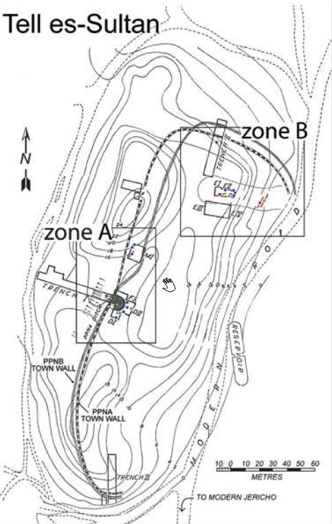 Figure 2
Map of coseismic effects at Tell es-Sultan between 7500 and 6000 BC (Pre-Pottery Neolithic B). The locations of the effects are marked by numbers (descriptions as in Table 2). Original plan of the Tell modified from Kenyon (1981) click on image to open in a new tab Alfonsi et al. (2012) 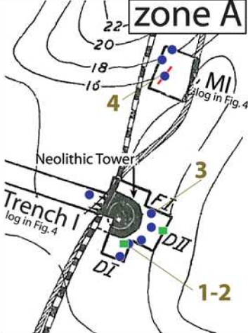 Figure 2
Map of coseismic effects at Tell es-Sultan between 7500 and 6000 BC (Pre-Pottery Neolithic B). The locations of the effects are marked by numbers (descriptions as in Table 2). Original plan of the Tell modified from Kenyon (1981) click on image to open in a new tab Alfonsi et al. (2012) |
|
|
|
Stage D I, XVII A,
F I xxxi, D I xlii,
D II xxx–xxxi
Point 2
Figure 2
Map of coseismic effects at Tell es-Sultan between 7500 and 6000 BC (Pre-Pottery Neolithic B). The locations of the effects are marked by numbers (descriptions as in Table 2). Original plan of the Tell modified from Kenyon (1981) click on image to open in a new tab Alfonsi et al. (2012)
Figure 2
Map of coseismic effects at Tell es-Sultan between 7500 and 6000 BC (Pre-Pottery Neolithic B). The locations of the effects are marked by numbers (descriptions as in Table 2). Original plan of the Tell modified from Kenyon (1981) click on image to open in a new tab Alfonsi et al. (2012) |
Figure 3b Photos illustrating some of the effects caused by seismic shaking at Tell es-Sultan (numbered as in Figure 2 and Table 2). (b) Human skeleton found under a collapsed wall. Original picture from Kenyon (1981). Alfonsi et al. (2012) |
|
|
F I, stage XXIII–XXIV,
F I xxxvii–xxxviii,
D I xlvi–xlvii,
D II xxxiv–xxxv
Point 3
Figure 2
Map of coseismic effects at Tell es-Sultan between 7500 and 6000 BC (Pre-Pottery Neolithic B). The locations of the effects are marked by numbers (descriptions as in Table 2). Original plan of the Tell modified from Kenyon (1981) click on image to open in a new tab Alfonsi et al. (2012)
Figure 2
Map of coseismic effects at Tell es-Sultan between 7500 and 6000 BC (Pre-Pottery Neolithic B). The locations of the effects are marked by numbers (descriptions as in Table 2). Original plan of the Tell modified from Kenyon (1981) click on image to open in a new tab Alfonsi et al. (2012) |
Figure 3c Photos illustrating some of the effects caused by seismic shaking at Tell es-Sultan (numbered as in Figure 2 and Table 2). (c) View from the top of a complete northward collapse of a wall, giving the illusion of a pavement. Original picture from Garstang and Garstang (1948). Original picture from Kenyon (1981) Alfonsi et al. (2012) |
|
|
Square M, stage XI,
phases lxiv–lxvia
Point 4
Figure 2
Map of coseismic effects at Tell es-Sultan between 7500 and 6000 BC (Pre-Pottery Neolithic B). The locations of the effects are marked by numbers (descriptions as in Table 2). Original plan of the Tell modified from Kenyon (1981) click on image to open in a new tab Alfonsi et al. (2012)
Figure 2
Map of coseismic effects at Tell es-Sultan between 7500 and 6000 BC (Pre-Pottery Neolithic B). The locations of the effects are marked by numbers (descriptions as in Table 2). Original plan of the Tell modified from Kenyon (1981) click on image to open in a new tab Alfonsi et al. (2012)
Figure 4Archaeoseismic stratigraphic sections modified from Garstang and Garstang (1948) and Kenyon (1981). Dashed squares in Garstang’s section are the approximate projections of Kenyon’s excavations both from zone A (logs in the inset) and zone B. The time— space relations between the layers and the observed coseismic effects (point numbers as in Figure 2 and Table 2) are illustrated. Horizons of the seismic shaking events recognized within the Pre-Pottery Neolithic B period are marked by stars. Click on image to open in a new tab Alfonsi et al. (2012) |
Figure 3a Photos illustrating some of the effects caused by seismic shaking at Tell es-Sultan (numbered as in Figure 2 and Table 2). (a) Black arrows point to fractures crossing the floor and the perimeter wall of Pre-Pottery Neolithic B houses. Original picture from Kenyon (1981). Alfonsi et al. (2012) |
|
|
Trench II, stage IX,
phase xxxiv–xxxvi
Point 5
Figure 2
Map of coseismic effects at Tell es-Sultan between 7500 and 6000 BC (Pre-Pottery Neolithic B). The locations of the effects are marked by numbers (descriptions as in Table 2). Original plan of the Tell modified from Kenyon (1981) click on image to open in a new tab Alfonsi et al. (2012) |
|
|
|
Squares E’s stage X,
phase xxxviii
Point 6
Figure 2
Map of coseismic effects at Tell es-Sultan between 7500 and 6000 BC (Pre-Pottery Neolithic B). The locations of the effects are marked by numbers (descriptions as in Table 2). Original plan of the Tell modified from Kenyon (1981) click on image to open in a new tab Alfonsi et al. (2012) |
|
|
|
Squares E’s, stage XI,
phase xlv—stage XII,
phase xvi
Point 7
Figure 2
Map of coseismic effects at Tell es-Sultan between 7500 and 6000 BC (Pre-Pottery Neolithic B). The locations of the effects are marked by numbers (descriptions as in Table 2). Original plan of the Tell modified from Kenyon (1981) click on image to open in a new tab Alfonsi et al. (2012) |
|
|
|
Squares E’s stage XII,
phase xlvii
Point 8
Figure 2
Map of coseismic effects at Tell es-Sultan between 7500 and 6000 BC (Pre-Pottery Neolithic B). The locations of the effects are marked by numbers (descriptions as in Table 2). Original plan of the Tell modified from Kenyon (1981) click on image to open in a new tab Alfonsi et al. (2012) 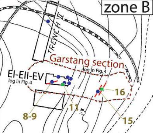 Figure 2
Map of coseismic effects at Tell es-Sultan between 7500 and 6000 BC (Pre-Pottery Neolithic B). The locations of the effects are marked by numbers (descriptions as in Table 2). Original plan of the Tell modified from Kenyon (1981) click on image to open in a new tab Alfonsi et al. (2012) |
|
|
|
Square E’s, stage XIII,
phase liii
Point 9
Figure 2
Map of coseismic effects at Tell es-Sultan between 7500 and 6000 BC (Pre-Pottery Neolithic B). The locations of the effects are marked by numbers (descriptions as in Table 2). Original plan of the Tell modified from Kenyon (1981) click on image to open in a new tab Alfonsi et al. (2012)
Figure 2
Map of coseismic effects at Tell es-Sultan between 7500 and 6000 BC (Pre-Pottery Neolithic B). The locations of the effects are marked by numbers (descriptions as in Table 2). Original plan of the Tell modified from Kenyon (1981) click on image to open in a new tab Alfonsi et al. (2012)
Figure 4Archaeoseismic stratigraphic sections modified from Garstang and Garstang (1948) and Kenyon (1981). Dashed squares in Garstang’s section are the approximate projections of Kenyon’s excavations both from zone A (logs in the inset) and zone B. The time— space relations between the layers and the observed coseismic effects (point numbers as in Figure 2 and Table 2) are illustrated. Horizons of the seismic shaking events recognized within the Pre-Pottery Neolithic B period are marked by stars. Click on image to open in a new tab Alfonsi et al. (2012) |
|
|
|
Squares E’s stage XIII,
phase liv
Point 10
Figure 2
Map of coseismic effects at Tell es-Sultan between 7500 and 6000 BC (Pre-Pottery Neolithic B). The locations of the effects are marked by numbers (descriptions as in Table 2). Original plan of the Tell modified from Kenyon (1981) click on image to open in a new tab Alfonsi et al. (2012) |
|
|
|
Square E’s stage XIII,
phase lv–lvi
Point 11
Figure 2
Map of coseismic effects at Tell es-Sultan between 7500 and 6000 BC (Pre-Pottery Neolithic B). The locations of the effects are marked by numbers (descriptions as in Table 2). Original plan of the Tell modified from Kenyon (1981) click on image to open in a new tab Alfonsi et al. (2012)
Figure 2
Map of coseismic effects at Tell es-Sultan between 7500 and 6000 BC (Pre-Pottery Neolithic B). The locations of the effects are marked by numbers (descriptions as in Table 2). Original plan of the Tell modified from Kenyon (1981) click on image to open in a new tab Alfonsi et al. (2012) |
|
|
|
Square E’s XIII,
phase lvii
Point 12
Figure 2
Map of coseismic effects at Tell es-Sultan between 7500 and 6000 BC (Pre-Pottery Neolithic B). The locations of the effects are marked by numbers (descriptions as in Table 2). Original plan of the Tell modified from Kenyon (1981) click on image to open in a new tab Alfonsi et al. (2012) |
|
|
|
Square E’s stage XIV,
phase lxi
Point 13
Figure 2
Map of coseismic effects at Tell es-Sultan between 7500 and 6000 BC (Pre-Pottery Neolithic B). The locations of the effects are marked by numbers (descriptions as in Table 2). Original plan of the Tell modified from Kenyon (1981) click on image to open in a new tab Alfonsi et al. (2012) |
|
|
|
Square E’s stage XV,
phase lxv
Point 14
Figure 2
Map of coseismic effects at Tell es-Sultan between 7500 and 6000 BC (Pre-Pottery Neolithic B). The locations of the effects are marked by numbers (descriptions as in Table 2). Original plan of the Tell modified from Kenyon (1981) click on image to open in a new tab Alfonsi et al. (2012) |
|
|
|
Garstang’s excavation
level X–XIm
Point 15
Figure 2
Map of coseismic effects at Tell es-Sultan between 7500 and 6000 BC (Pre-Pottery Neolithic B). The locations of the effects are marked by numbers (descriptions as in Table 2). Original plan of the Tell modified from Kenyon (1981) click on image to open in a new tab Alfonsi et al. (2012)
Figure 2
Map of coseismic effects at Tell es-Sultan between 7500 and 6000 BC (Pre-Pottery Neolithic B). The locations of the effects are marked by numbers (descriptions as in Table 2). Original plan of the Tell modified from Kenyon (1981) click on image to open in a new tab Alfonsi et al. (2012)
Figure 4Archaeoseismic stratigraphic sections modified from Garstang and Garstang (1948) and Kenyon (1981). Dashed squares in Garstang’s section are the approximate projections of Kenyon’s excavations both from zone A (logs in the inset) and zone B. The time— space relations between the layers and the observed coseismic effects (point numbers as in Figure 2 and Table 2) are illustrated. Horizons of the seismic shaking events recognized within the Pre-Pottery Neolithic B period are marked by stars. Click on image to open in a new tab Alfonsi et al. (2012) |
Figure 3d Photos illustrating some of the effects caused by seismic shaking at Tell es-Sultan (numbered as in Figure 2 and Table 2). (d) East view of the Garstang excavation. Visible in the foreground is a fracture crossing the floor and the adjacent wall affecting layer X, dated as the latest stage of Pre–Pottery Neolithic B. Original picture from Garstang and Garstang (1948). click on image to open in a new tab Alfonsi et al. (2012) |
|
|
Great Garstang’s
level XI
Point 16
Figure 2
Map of coseismic effects at Tell es-Sultan between 7500 and 6000 BC (Pre-Pottery Neolithic B). The locations of the effects are marked by numbers (descriptions as in Table 2). Original plan of the Tell modified from Kenyon (1981) click on image to open in a new tab Alfonsi et al. (2012)
Figure 2
Map of coseismic effects at Tell es-Sultan between 7500 and 6000 BC (Pre-Pottery Neolithic B). The locations of the effects are marked by numbers (descriptions as in Table 2). Original plan of the Tell modified from Kenyon (1981) click on image to open in a new tab Alfonsi et al. (2012)
Figure 4Archaeoseismic stratigraphic sections modified from Garstang and Garstang (1948) and Kenyon (1981). Dashed squares in Garstang’s section are the approximate projections of Kenyon’s excavations both from zone A (logs in the inset) and zone B. The time— space relations between the layers and the observed coseismic effects (point numbers as in Figure 2 and Table 2) are illustrated. Horizons of the seismic shaking events recognized within the Pre-Pottery Neolithic B period are marked by stars. Click on image to open in a new tab Alfonsi et al. (2012) |
Figure 3f Photos illustrating some of the effects caused by seismic shaking at Tell es-Sultan (numbered as in Figure 2 and Table 2). (f) Black arrows point to a fracture crossing a pavement and a skeleton. An apparent displacement of skull versus body is observable. The white circle inscribes the possible correspondence between the cervical and neck bones (black dots). Original picture from Garstang and Garstang (1948). click on image to open in a new tab Alfonsi et al. (2012) |
|
|
Trench III, stage IX,
phase xxi–xxii
Point 17
Figure 2
Map of coseismic effects at Tell es-Sultan between 7500 and 6000 BC (Pre-Pottery Neolithic B). The locations of the effects are marked by numbers (descriptions as in Table 2). Original plan of the Tell modified from Kenyon (1981) click on image to open in a new tab Alfonsi et al. (2012) |
|
|
|
F I, stage XXVI,
phase xliii, D I I
Point 18
Figure 2
Map of coseismic effects at Tell es-Sultan between 7500 and 6000 BC (Pre-Pottery Neolithic B). The locations of the effects are marked by numbers (descriptions as in Table 2). Original plan of the Tell modified from Kenyon (1981) click on image to open in a new tab Alfonsi et al. (2012) |
|
| Effect(s) | Location | Image(s) | Description |
|---|---|---|---|
|
Trench III (Site N)
Figure 3 Plan of Jericho Click on image to open in a new tab Kenyon (1957)
Fig. 1Composite sketch plan of excavations 1907–1958 Click on image to open in a new tab Kenyon (1981 v.3a)
Fig. 3Plan of Early Bronze Age Town Walls Click on image to open in a new tab Kenyon (1981 v.3a)
Plate 267
Trench III Plans:
Click on image to open in a new tab Kenyon et al. (1981 Part 2) |
Plate 273 Trench III. West Section. Errata: Metre numbers 0-12 S. at bottom N. end of trench incorrectly numbered 22-12. Lettering of Wall NEN, betweeen 1.60 m. and 2.20 m. S., 11.70 m. H., omitted. Phase lxxvi-lxxviia, between c. 1.50 m. and 3.50 m. S., 15 m. and 16.30 m. H., incorrectly numbered lxxvi-lxxiia. Click on image to open in a new tab Kenyon et al. (1981 Part 2)
Plate 274Trench III. Sections and Key.
Click on image to open in a new tab Kenyon et al. (1981 Part 2) |
|
| Effect(s) | Location | Image(s) | Description |
|---|---|---|---|
|
Wall B of Town Wall 1 in Areas FI, DI, and DII adjacent to and due east of Trench I
Figure 6 Plan of EB II (3000–2700 B.C.E) city of Jericho. Click on image to open in a new tab Nigro (2016)
Figure 3Plan of Jericho Click on image to open in a new tab Kenyon (1957)
Fig. 1Composite sketch plan of excavations 1907–1958 Click on image to open in a new tab Kenyon (1981 v.3a)
Fig. 3Plan of Early Bronze Age Town Walls Click on image to open in a new tab Kenyon (1981 v.3a) |
Plate 79b
Plate 79b
Tower built against Town Wall A (p. 97) click on image to open in a new tab Kenyon et al. (1981) Plate 80a
Plate 80a
Foundations of tower and face of Town Wall B (p. 97) click on image to open in a new tab Kenyon et al. (1981) Pl. 236
Plate 236
Square FI. Section A-B
Erratum: Hatching of diagonally dotted lines incorrect for phase FI.xliii between c. 0.75 m. and 2 m. W., 11.40 m. and 12 m. H. and betweeen c. 6.30 m. and 7.50 m. W., 10.70 m. and 11.20 m. H. Click on image to open in a new tab Kenyon et al. (1981 Part 2) Pl. 240
Tr.I, FI, DI. Sections:
Click on image to open in a new tab Kenyon et al. (1981 Part 2) |
|
|
Town Wall 1 in Site A
Figure 6 Plan of EB II (3000–2700 B.C.E) city of Jericho. Click on image to open in a new tab Nigro (2016)
Figure 3Plan of Jericho Click on image to open in a new tab Kenyon (1957)
Fig. 1Composite sketch plan of excavations 1907–1958 Click on image to open in a new tab Kenyon (1981 v.3a)
Fig. 3Plan of Early Bronze Age Town Walls Click on image to open in a new tab Kenyon (1981 v.3a) |
Plate 343a
Plate 343a
Site A, South Section Click on image to open in a new tab Kenyon et al. (1981 Part 2) Fig. 38 (equivalent to 200a)
Figure 38Example of a town wall of the Early Bronze Age destroyed by an earthquake. At the base, beside the survey pole, the stone foundations and, spreading to the right, the face of the brick wall collapsed onto the contemporary surface. click on image to open in a new tab Kenyon (1978) Fig. 38
Figure 38Example of a town wall of the Early Bronze Age destroyed by an earthquake. JW: Ordered fall of mud-bricks from the face of the town wall is shaded red while the disordered wall of mud-bricks from the core of the wall is shaded pink. click on image to open in a new tab Kenyon (1978) Plate 200b
Plate 200bSite A. At base, by foot of survey pole, stone foundations of lowest wall reached, with the collapse of the brick superstructure to right (pp. 372 ff/) click on image to open in a new tab Kenyon et al. (1981) Fig. 16
Figure 16Dune-yellowish mudbricks tumble down from the EB II city wall at Kenyon’s Site A (after Kenyon 1981, pl. 200b). click on image to open in a new tab Nigro (2014) Plate 100a
Plate 100a
Stone foundation of phase Tr.II.xlviii house OBM (p.146) click on image to open in a new tab Kenyon et al. (1981) |
|
|
Trenches I, II, and II in addition to Square M, site A, and houses on the northern plateau
Figure 6 Plan of EB II (3000–2700 B.C.E) city of Jericho. Click on image to open in a new tab Nigro (2016)
Figure 3Plan of Jericho Click on image to open in a new tab Kenyon (1957)
Fig. 1Composite sketch plan of excavations 1907–1958 Click on image to open in a new tab Kenyon (1981 v.3a)
Fig. 3Plan of Early Bronze Age Town Walls Click on image to open in a new tab Kenyon (1981 v.3a) |
|
| Effect(s) | Location | Image(s) | Description |
|---|---|---|---|
|
Fortification Walls
Figure 2 Map of Tell es-Sultan/ancient Jericho with excavated areas. Click on image to open in a new tab Nigro (2016)
Figure 8Reconstructive plan of the EB III city at Tell es-Sultan/Jericho. Click on image to open in a new tab Nigro (2016) |
Fig. 18
Figure 18 EB IIIA Inner Gate L.1800, filled up with collapsed mudbricks and burnt beams, from north-east. click on image to open in a new tab Nigro (2014) |
|
| Effect(s) | Location | Image(s) | Description |
|---|---|---|---|
|
Square AqIV13
Figure 2 Tell es-Sultan with the areas excavated by the Italian-Palestinian Expedition (1997-2000) and the Austro-German and British Expeditions. Click on image to open in a new tab Nigro and Taha (2006)
Figure 2Map of Tell es-Sultan/ancient Jericho with excavated areas. Click on image to open in a new tab Nigro (2016) |
|
| Effect(s) | Location | Image(s) | Description |
|---|---|---|---|
|
Figure 3 Plan of Jericho Click on image to open in a new tab Kenyon (1957)
Fig. 1Composite sketch plan of excavations 1907–1958 Click on image to open in a new tab Kenyon (1981 v.3a)
Figure 1Composite map of the ancient city of Jericho based on multiple excavations click on image to open in a new tab Kennedy (2023)
Fig. 4Plan of Middle Bronze Age town rampart and revetment Click on image to open in a new tab Kenyon (1981 v.3a) |
Pl. 62A
Plate 62A Buildings of Middle Bronze age Jericho, destroyed by fire. In background the wash of burnt material which overlay them. click on image to open in a new tab Kenyon (1957) Pl. 62A annotated
Plate 62ABuildings of Middle Bronze age Jericho, destroyed by fire. In background the wash of burnt material which overlay them. Burnt material shaded pink (by JW) click on image to open in a new tab Kenyon (1957) Fig.4
Figure 4Stratigraphic section of the final Bronze Age destruction layer at Jericho from a Kenyon excavated square on the eastern side of the city, showing collapsed building materials, pottery, charcoal, and ash. click on image to open in a new tab Kennedy (2023)
click on image to open in a new tab Wood (1990a) 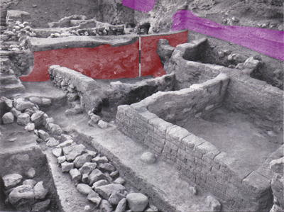 Same as image above except destruction layer is shaded red and erosion layer is shaded pink (by JW)
click on image to open in a new tab modified from Wood (1990a)
click on image to open in a new tab Wood (1990a)
Figure 2Cross section of Trench I showing the Jericho outer city wall built in Middle Bronze III. The pile of fallen mudbricks in the form of a ramp in front of the stone retaining wall originally comprised a mudbrick wall atop the stone retaining wall. click on image to open in a new tab Kennedy (2023)
Figure 4Section of Trench 1 Click on image to open in a new tab Kenyon (1957) |
|
-
Earthquake Archeological Effects chart
of Rodríguez-Pascua et al (2013: 221-224)
 Earthquake Archeological Effects (EAE)
Rodríguez-Pascua et al (2013: 221-224)
| Effect | Location | Image(s) | Description | Intensity |
|---|---|---|---|---|
| Collapsed Walls | different sections of the site
Figure 2 Map of Tell es-Sultan/ancient Jericho with excavated areas. Photograph and Image by Lorenzo Nigro, © University of Rome “La Sapienza” ROSAPAJ Nigro (2016) |
|
VIII+ |
-
Earthquake Archeological Effects chart
of Rodríguez-Pascua et al (2013: 221-224)
Earthquake Archeological Effects (EAE)
Rodríguez-Pascua et al (2013: 221-224)
| Effect | Location | Image(s) | Description | Intensity |
|---|---|---|---|---|
| Skeletons beneath collapse | Point 2 (Kenyon's Trench 1)
Figure 2 Map of coseismic effects at Tell es-Sultan Zone A between 7,500 and 6,000 B.C. (Pre–Pottery Neolithic B). The locations of the effects are marked by numbers (descriptions as in Table 2). Original plan of the Tell modified from Kenyon (1981) Alfonsi et al. (2012)
Figure 2Map of coseismic effects at Tell es-Sultan (Entire Tell) between 7,500 and 6,000 B.C. (Pre–Pottery Neolithic B). The locations of the effects are marked by numbers (descriptions as in Table 2). Original plan of the Tell modified from Kenyon (1981) Alfonsi et al. (2012)
Figure 4Archaeoseismic stratigraphic sections modified from Garstang and Garstang (1948) and Kenyon (1981). Dashed squares in Garstang’s section are the approximate projections of Kenyon’s excavations both from zone A (logs in the inset) and zone B. The time— space relations between the layers and the observed coseismic effects (point numbers as in Figure 2 and Table 2) are illustrated. Horizons of the seismic shaking events recognized within the Pre-Pottery Neolithic B period are marked by stars. Alfonsi et al. (2012) |
Figure 3b Photos illustrating some of the effects caused by seismic shaking at Tell es-Sultan (numbered as in Figure 2 and Table 2). (b) Human skeleton found under a collapsed wall. Original picture from Kenyon (1981). Alfonsi et al. (2012) |
|
VIII+ |
| Surface fracturing | Point 4
Figure 2 Map of coseismic effects at Tell es-Sultan Zone A between 7,500 and 6,000 B.C. (Pre–Pottery Neolithic B). The locations of the effects are marked by numbers (descriptions as in Table 2). Original plan of the Tell modified from Kenyon (1981) Alfonsi et al. (2012)
Figure 2Map of coseismic effects at Tell es-Sultan (Entire Tell) between 7,500 and 6,000 B.C. (Pre–Pottery Neolithic B). The locations of the effects are marked by numbers (descriptions as in Table 2). Original plan of the Tell modified from Kenyon (1981) Alfonsi et al. (2012)
Figure 4Archaeoseismic stratigraphic sections modified from Garstang and Garstang (1948) and Kenyon (1981). Dashed squares in Garstang’s section are the approximate projections of Kenyon’s excavations both from zone A (logs in the inset) and zone B. The time— space relations between the layers and the observed coseismic effects (point numbers as in Figure 2 and Table 2) are illustrated. Horizons of the seismic shaking events recognized within the Pre-Pottery Neolithic B period are marked by stars. Alfonsi et al. (2012) |
|
? | |
|
Point 9
Figure 2 Map of coseismic effects at Tell es-Sultan Zone B between 7,500 and 6,000 B.C. (Pre–Pottery Neolithic B). The locations of the effects are marked by numbers (descriptions as in Table 2). Original plan of the Tell modified from Kenyon (1981) Alfonsi et al. (2012)
Figure 2Map of coseismic effects at Tell es-Sultan (Entire Tell) between 7,500 and 6,000 B.C. (Pre–Pottery Neolithic B). The locations of the effects are marked by numbers (descriptions as in Table 2). Original plan of the Tell modified from Kenyon (1981) Alfonsi et al. (2012)
Figure 4Archaeoseismic stratigraphic sections modified from Garstang and Garstang (1948) and Kenyon (1981). Dashed squares in Garstang’s section are the approximate projections of Kenyon’s excavations both from zone A (logs in the inset) and zone B. The time— space relations between the layers and the observed coseismic effects (point numbers as in Figure 2 and Table 2) are illustrated. Horizons of the seismic shaking events recognized within the Pre-Pottery Neolithic B period are marked by stars. Alfonsi et al. (2012) |
Figure 3a Photos illustrating some of the effects caused by seismic shaking at Tell es-Sultan (numbered as in Figure 2 and Table 2). (a) Black arrows point to fractures crossing the floor and the perimeter wall of Pre-Pottery Neolithic B houses. Original picture from Kenyon (1981). Alfonsi et al. (2012) |
|
|
-
Earthquake Archeological Effects chart
of Rodríguez-Pascua et al (2013: 221-224)
Earthquake Archeological Effects (EAE)
Rodríguez-Pascua et al (2013: 221-224)
| Effect | Location | Image(s) | Description | Intensity |
|---|---|---|---|---|
|
Point 3
Figure 2 Map of coseismic effects at Tell es-Sultan Zone A between 7,500 and 6,000 B.C. (Pre–Pottery Neolithic B). The locations of the effects are marked by numbers (descriptions as in Table 2). Original plan of the Tell modified from Kenyon (1981) Alfonsi et al. (2012)
Figure 2Map of coseismic effects at Tell es-Sultan (Entire Tell) between 7,500 and 6,000 B.C. (Pre–Pottery Neolithic B). The locations of the effects are marked by numbers (descriptions as in Table 2). Original plan of the Tell modified from Kenyon (1981) Alfonsi et al. (2012)
Figure 4Archaeoseismic stratigraphic sections modified from Garstang and Garstang (1948) and Kenyon (1981). Dashed squares in Garstang’s section are the approximate projections of Kenyon’s excavations both from zone A (logs in the inset) and zone B. The time— space relations between the layers and the observed coseismic effects (point numbers as in Figure 2 and Table 2) are illustrated. Horizons of the seismic shaking events recognized within the Pre-Pottery Neolithic B period are marked by stars. Alfonsi et al. (2012) |
Figure 3c Photos illustrating some of the effects caused by seismic shaking at Tell es-Sultan (numbered as in Figure 2 and Table 2). (c) View from the top of a complete northward collapse of a wall, giving the illusion of a pavement. Original picture from Kenyon (1981) Alfonsi et al. (2012) |
|
|
| Surface fracturing | Point 15
Figure 2 Map of coseismic effects at Tell es-Sultan Zone B between 7,500 and 6,000 B.C. (Pre–Pottery Neolithic B). The locations of the effects are marked by numbers (descriptions as in Table 2). Original plan of the Tell modified from Kenyon (1981) Alfonsi et al. (2012)
Figure 2Map of coseismic effects at Tell es-Sultan (Entire Tell) between 7,500 and 6,000 B.C. (Pre–Pottery Neolithic B). The locations of the effects are marked by numbers (descriptions as in Table 2). Original plan of the Tell modified from Kenyon (1981) Alfonsi et al. (2012)
Figure 4Archaeoseismic stratigraphic sections modified from Garstang and Garstang (1948) and Kenyon (1981). Dashed squares in Garstang’s section are the approximate projections of Kenyon’s excavations both from zone A (logs in the inset) and zone B. The time— space relations between the layers and the observed coseismic effects (point numbers as in Figure 2 and Table 2) are illustrated. Horizons of the seismic shaking events recognized within the Pre-Pottery Neolithic B period are marked by stars. Alfonsi et al. (2012) |
Figure 3d Photos illustrating some of the effects caused by seismic shaking at Tell es-Sultan (numbered as in Figure 2 and Table 2). (d) East view of the Garstang excavation. Visible in the foreground is a fracture crossing the floor and the adjacent wall affecting layer X, dated as the latest stage of Pre–Pottery Neolithic B. Original picture from Garstang and Garstang (1948). Alfonsi et al. (2012) |
|
? |
|
Point 16
Figure 2 Map of coseismic effects at Tell es-Sultan Zone B between 7,500 and 6,000 B.C. (Pre–Pottery Neolithic B). The locations of the effects are marked by numbers (descriptions as in Table 2). Original plan of the Tell modified from Kenyon (1981) Alfonsi et al. (2012)
Figure 2Map of coseismic effects at Tell es-Sultan (Entire Tell) between 7,500 and 6,000 B.C. (Pre–Pottery Neolithic B). The locations of the effects are marked by numbers (descriptions as in Table 2). Original plan of the Tell modified from Kenyon (1981) Alfonsi et al. (2012)
Figure 4Archaeoseismic stratigraphic sections modified from Garstang and Garstang (1948) and Kenyon (1981). Dashed squares in Garstang’s section are the approximate projections of Kenyon’s excavations both from zone A (logs in the inset) and zone B. The time— space relations between the layers and the observed coseismic effects (point numbers as in Figure 2 and Table 2) are illustrated. Horizons of the seismic shaking events recognized within the Pre-Pottery Neolithic B period are marked by stars. Alfonsi et al. (2012) |
Figure 3f Photos illustrating some of the effects caused by seismic shaking at Tell es-Sultan (numbered as in Figure 2 and Table 2). (f) Black arrows point to a fracture crossing a pavement and a skeleton. An apparent displacement of skull versus body is observable. The white circle inscribes the possible correspondence between the cervical and neck bones (black dots). Original picture from Garstang and Garstang (1948). Alfonsi et al. (2012) |
|
|
- Earthquake Archeological Effects chart
of Rodríguez-Pascua et al (2013: 221-224)
Earthquake Archeological Effects (EAE)
Rodríguez-Pascua et al (2013: 221-224)
| Effect(s) | Location | Image(s) | Description | Intensity |
|---|---|---|---|---|
|
Trench III (Site N)
Figure 3 Plan of Jericho Click on image to open in a new tab Kenyon (1957)
Fig. 1Composite sketch plan of excavations 1907–1958 Click on image to open in a new tab Kenyon (1981 v.3a)
Fig. 3Plan of Early Bronze Age Town Walls Click on image to open in a new tab Kenyon (1981 v.3a)
Plate 267
Trench III Plans:
Click on image to open in a new tab Kenyon et al. (1981 Part 2) |
Plate 273 Trench III. West Section. Errata: Metre numbers 0-12 S. at bottom N. end of trench incorrectly numbered 22-12. Lettering of Wall NEN, betweeen 1.60 m. and 2.20 m. S., 11.70 m. H., omitted. Phase lxxvi-lxxviia, between c. 1.50 m. and 3.50 m. S., 15 m. and 16.30 m. H., incorrectly numbered lxxvi-lxxiia. Click on image to open in a new tab Kenyon et al. (1981 Part 2)
Plate 274Trench III. Sections and Key.
Click on image to open in a new tab Kenyon et al. (1981 Part 2) |
|
|
- Earthquake Archeological Effects chart
of Rodríguez-Pascua et al (2013: 221-224)
Earthquake Archeological Effects (EAE)
Rodríguez-Pascua et al (2013: 221-224)
| Effect(s) | Location | Image(s) | Description | Intensity |
|---|---|---|---|---|
|
Wall B of Town Wall 1 in Areas FI, DI, and DII adjacent to and due east of Trench I
Figure 6 Plan of EB II (3000–2700 B.C.E) city of Jericho. Click on image to open in a new tab Nigro (2016)
Figure 3Plan of Jericho Click on image to open in a new tab Kenyon (1957)
Fig. 1Composite sketch plan of excavations 1907–1958 Click on image to open in a new tab Kenyon (1981 v.3a)
Fig. 3Plan of Early Bronze Age Town Walls Click on image to open in a new tab Kenyon (1981 v.3a) |
Plate 79b
Plate 79b
Tower built against Town Wall A (p. 97) click on image to open in a new tab Kenyon et al. (1981) Plate 80a
Plate 80a
Foundations of tower and face of Town Wall B (p. 97) click on image to open in a new tab Kenyon et al. (1981) Pl. 236
Plate 236
Square FI. Section A-B
Erratum: Hatching of diagonally dotted lines incorrect for phase FI.xliii between c. 0.75 m. and 2 m. W., 11.40 m. and 12 m. H. and betweeen c. 6.30 m. and 7.50 m. W., 10.70 m. and 11.20 m. H. Click on image to open in a new tab Kenyon et al. (1981 Part 2) Pl. 240
Tr.I, FI, DI. Sections:
Click on image to open in a new tab Kenyon et al. (1981 Part 2) |
|
|
|
Town Wall 1 in Site A
Figure 6 Plan of EB II (3000–2700 B.C.E) city of Jericho. Click on image to open in a new tab Nigro (2016)
Figure 3Plan of Jericho Click on image to open in a new tab Kenyon (1957)
Fig. 1Composite sketch plan of excavations 1907–1958 Click on image to open in a new tab Kenyon (1981 v.3a)
Fig. 3Plan of Early Bronze Age Town Walls Click on image to open in a new tab Kenyon (1981 v.3a) |
Plate 343a
Plate 343a
Site A, South Section Click on image to open in a new tab Kenyon et al. (1981 Part 2) Fig. 38 (equivalent to 200a)
Figure 38Example of a town wall of the Early Bronze Age destroyed by an earthquake. At the base, beside the survey pole, the stone foundations and, spreading to the right, the face of the brick wall collapsed onto the contemporary surface. click on image to open in a new tab Kenyon (1978) Fig. 38
Figure 38Example of a town wall of the Early Bronze Age destroyed by an earthquake. JW: Ordered fall of mud-bricks from the face of the town wall is shaded red while the disordered wall of mud-bricks from the core of the wall is shaded pink. click on image to open in a new tab Kenyon (1978) Plate 200b
Plate 200bSite A. At base, by foot of survey pole, stone foundations of lowest wall reached, with the collapse of the brick superstructure to right (pp. 372 ff/) click on image to open in a new tab Kenyon et al. (1981) Fig. 16
Figure 16Dune-yellowish mudbricks tumble down from the EB II city wall at Kenyon’s Site A (after Kenyon 1981, pl. 200b). click on image to open in a new tab Nigro (2014) Plate 100a
Plate 100a
Stone foundation of phase Tr.II.xlviii house OBM (p.146) click on image to open in a new tab Kenyon et al. (1981) |
|
|
|
Trenches I, II, and II in addition to Square M, site A, and houses on the northern plateau
Figure 6 Plan of EB II (3000–2700 B.C.E) city of Jericho. Click on image to open in a new tab Nigro (2016)
Figure 3Plan of Jericho Click on image to open in a new tab Kenyon (1957)
Fig. 1Composite sketch plan of excavations 1907–1958 Click on image to open in a new tab Kenyon (1981 v.3a)
Fig. 3Plan of Early Bronze Age Town Walls Click on image to open in a new tab Kenyon (1981 v.3a) |
|
|
- Earthquake Archeological Effects chart
of Rodríguez-Pascua et al (2013: 221-224)
Earthquake Archeological Effects (EAE)
Rodríguez-Pascua et al (2013: 221-224)
| Effect(s) | Location | Image(s) | Description | Intensity |
|---|---|---|---|---|
|
Fortification Walls
Figure 2 Map of Tell es-Sultan/ancient Jericho with excavated areas. Click on image to open in a new tab Nigro (2016)
Figure 8Reconstructive plan of the EB III city at Tell es-Sultan/Jericho. Click on image to open in a new tab Nigro (2016) |
Fig. 18
Figure 18 EB IIIA Inner Gate L.1800, filled up with collapsed mudbricks and burnt beams, from north-east. click on image to open in a new tab Nigro (2014) |
|
|
- Earthquake Archeological Effects chart
of Rodríguez-Pascua et al (2013: 221-224)
Earthquake Archeological Effects (EAE)
Rodríguez-Pascua et al (2013: 221-224)
| Effect(s) | Location | Image(s) | Description | Intensity |
|---|---|---|---|---|
|
Square AqIV13
Figure 2 Tell es-Sultan with the areas excavated by the Italian-Palestinian Expedition (1997-2000) and the Austro-German and British Expeditions. Click on image to open in a new tab Nigro and Taha (2006)
Figure 2Map of Tell es-Sultan/ancient Jericho with excavated areas. Click on image to open in a new tab Nigro (2016) |
|
|
- Earthquake Archeological Effects chart
of Rodríguez-Pascua et al (2013: 221-224)
Earthquake Archeological Effects (EAE)
Rodríguez-Pascua et al (2013: 221-224)
| Effect(s) | Location | Image(s) | Description | Intensity |
|---|---|---|---|---|
|
Figure 3 Plan of Jericho Click on image to open in a new tab Kenyon (1957)
Fig. 1Composite sketch plan of excavations 1907–1958 Click on image to open in a new tab Kenyon (1981 v.3a)
Figure 1Composite map of the ancient city of Jericho based on multiple excavations click on image to open in a new tab Kennedy (2023)
Fig. 4Plan of Middle Bronze Age town rampart and revetment Click on image to open in a new tab Kenyon (1981 v.3a) |
Pl. 62A
Plate 62A Buildings of Middle Bronze age Jericho, destroyed by fire. In background the wash of burnt material which overlay them. click on image to open in a new tab Kenyon (1957) Pl. 62A annotated
Plate 62ABuildings of Middle Bronze age Jericho, destroyed by fire. In background the wash of burnt material which overlay them. Burnt material shaded pink (by JW) click on image to open in a new tab Kenyon (1957) Fig.4
Figure 4Stratigraphic section of the final Bronze Age destruction layer at Jericho from a Kenyon excavated square on the eastern side of the city, showing collapsed building materials, pottery, charcoal, and ash. click on image to open in a new tab Kennedy (2023)
click on image to open in a new tab Wood (1990a)
Same as image above except destruction layer is shaded red and erosion layer is shaded pink (by JW)
click on image to open in a new tab modified from Wood (1990a)
click on image to open in a new tab Wood (1990a)
Figure 2Cross section of Trench I showing the Jericho outer city wall built in Middle Bronze III. The pile of fallen mudbricks in the form of a ramp in front of the stone retaining wall originally comprised a mudbrick wall atop the stone retaining wall. click on image to open in a new tab Kennedy (2023)
Figure 4Section of Trench 1 Click on image to open in a new tab Kenyon (1957) |
|
|