Phase 2 Earthquake

Rattenborg and Blanke (2017:11)
report that structural collapse in Area GO, adjacent to the Mosque, destroyed
the subsurface compartment around the courtyard
cistern shaft
and forced the abandonment of two rooms in the northern wing
of Building B.
In the destruction layer of the
qiblat
Hall—described but not dated by
Barnes et al. (2006:295)—excavators
recovered more than five tonnes of roof-tile fragments from a thick,
uniform collapse layer. The hall’s layout and surviving architectural
elements point to a
triple-gabled roof that once
spanned the space. Looters removed whole tiles and much of the paving
after the collapse. Outside the mosque, massive stone tumble contrasts
sharply with the interior deposits, showing that the weight of the roof
drove the walls outward when they failed. Together, the tile
concentrations, the uniform collapse layer, and the outward fall of
masonry point to a single destructive event.
Rattenborg and Blanke (2017:11) argue
that this collapse occurred no earlier than the second half of the
9th century CE and may match damage recorded in residential units on the
Southwest Hill. Pottery from Building A’s paved floors (Phase 3/II)
supports a late 8th–9th century date. The assemblage includes
painted red terracotta,
cream, and
pale orange wares. A nearly complete
Cream Ware jug lay beneath wall collapse over
a paved floor. Comparable wares appear in Abbasid houses farther north
(Gawlikowski 1986, 1995) and in Area Z at Umm Qais (el-Khouri and Omoush
2015:17–20). Even so,
Rattenborg and Blanke (2017:15) warn
that archaeological evidence for the 9th–11th centuries remains sparse
and chronologically imprecise.
Rattenborg and Blanke (2017:13) also
describe how a late 9th- or early 10th-century collapse triggered a
partial rebuilding of the mosque. Only the western third of the prayer
hall returned to use, while the courtyard stayed in disrepair. Collapse
debris blocked the laneway along the mosque’s northwest perimeter and
cut off access from the main street. However, the passage leading from
the west entrance to the southwest corner shows no evidence of collapse,
suggesting that residents in the adjacent dwellings continued to use
this route after the disaster.
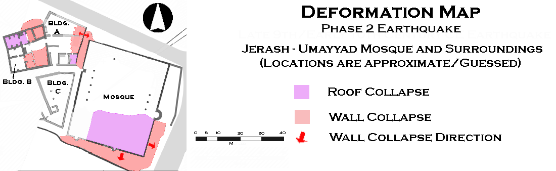 Deformation Map - Click on image top open in a new tab - Modified by JW from Fig. 12 of Rattenborg and Blanke (2017)
