Jerash - Bishop Isaiah Church
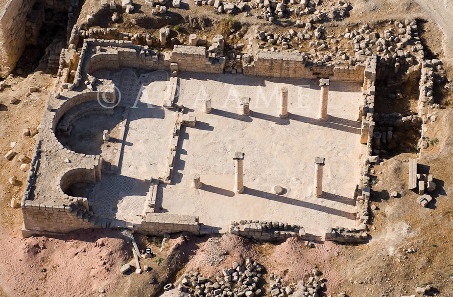 Jarash Bishop Isaiah Church
click on image to open in a new tab
Reference: APAAME_20080918_DLK-0142
Photographer: David Leslie Kennedy
Credit: Aerial Photographic Archive for Archaeology in the Middle East
Copyright: Creative Commons Attribution-Noncommercial-No Derivative Works
- Jerash - Bishop Isaiah Church in Google Earth
 Jerash - Bishop Isaiah Church
click on image to explore this site on a new tab in Google Earth
- Fig. 1 Plan showing
the location of the church from Clark (1986)
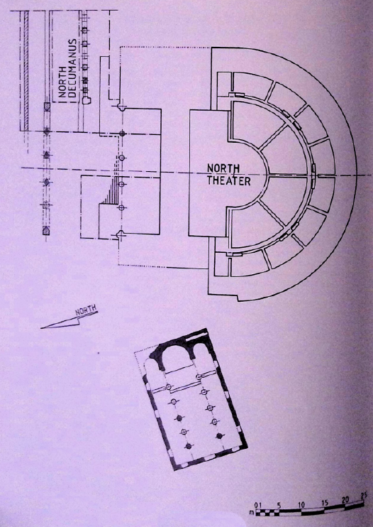 Figure 1
Plan showing the location of the church
Click on image to open in a new tab
Clark (1986) - Fig. 2 Plan of the
church from Clark (1986)
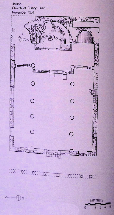 Figure 2
Plan of the church
Click on image to open in a new tab
Clark (1986) - Fig. 3 Trench location
plan of the Church Excavations from Clark (1986)
 Figure 3
Trench location plan of the Church Excavations
Click on image to open in a new tab
Clark (1986)
- Fig. 1 Plan showing
the location of the church from Clark (1986)
Figure 1
Plan showing the location of the church
Click on image to open in a new tab
Clark (1986) - Fig. 2 Plan of the
church from Clark (1986)
Figure 2
Plan of the church
Click on image to open in a new tab
Clark (1986) - Fig. 3 Trench location
plan of the Church Excavations from Clark (1986)
Figure 3
Trench location plan of the Church Excavations
Click on image to open in a new tab
Clark (1986)
| Seismic Effect | Location | Image(s) | Description |
|---|---|---|---|
|
Isaiah Church Plan of Jerash. North is to the right.
Click on image to open in a new tab Holger Behr - Wikipedia - Public Domain
Figure 1Plan showing the location of the church Click on image to open in a new tab Clark (1986)
Figure 2Plan of the church Click on image to open in a new tab Clark (1986)
Figure 3Trench location plan of the Church Excavations Click on image to open in a new tab Clark (1986) |
|
- Modified by JW from Fig. 3 of Clark (1986)
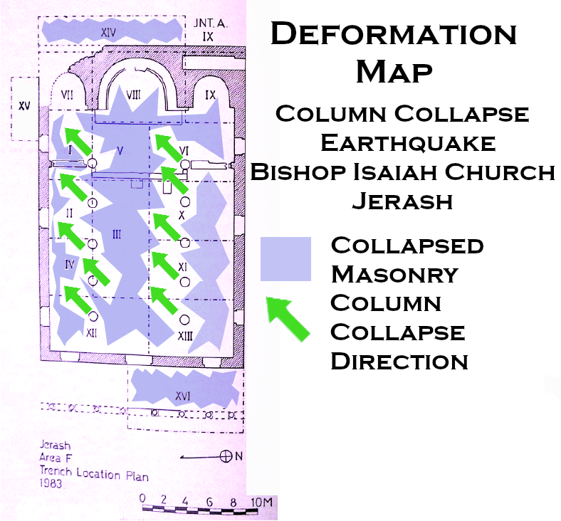 Deformation Map
Click on image to open in a new tab
Modified by JW from Fig. 3 of Clark (1986)
- Earthquake Archeological Effects chart
of Rodríguez-Pascua et al (2013: 221-224)
 Earthquake Archeological Effects (EAE)
Rodríguez-Pascua et al (2013: 221-224)
| Seismic Effect | Location | Image(s) | Description | Intensity |
|---|---|---|---|---|
|
Isaiah Church
Plan of Jerash. North is to the right.
Click on image to open in a new tab Holger Behr - Wikipedia - Public Domain
Figure 1Plan showing the location of the church Click on image to open in a new tab Clark (1986)
Figure 2Plan of the church Click on image to open in a new tab Clark (1986)
Figure 3Trench location plan of the Church Excavations Click on image to open in a new tab Clark (1986) |
|
|
- from Lichtenberger and Raja (2025)
- Table 2.2 List of seismic damage
in Jerash between the 1st and 19th centuries CE from Lichtenberger and Raja (2025)
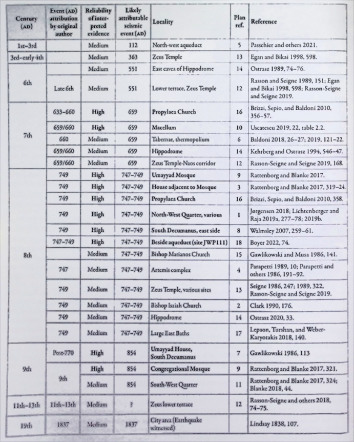 Table 2.2
List of seismically induced damage recorded in Gerasa where the relaibility of the evidence is considered to be medium or high
Click on Image to open in a new tab
Lichtenberger and Raja (2025)
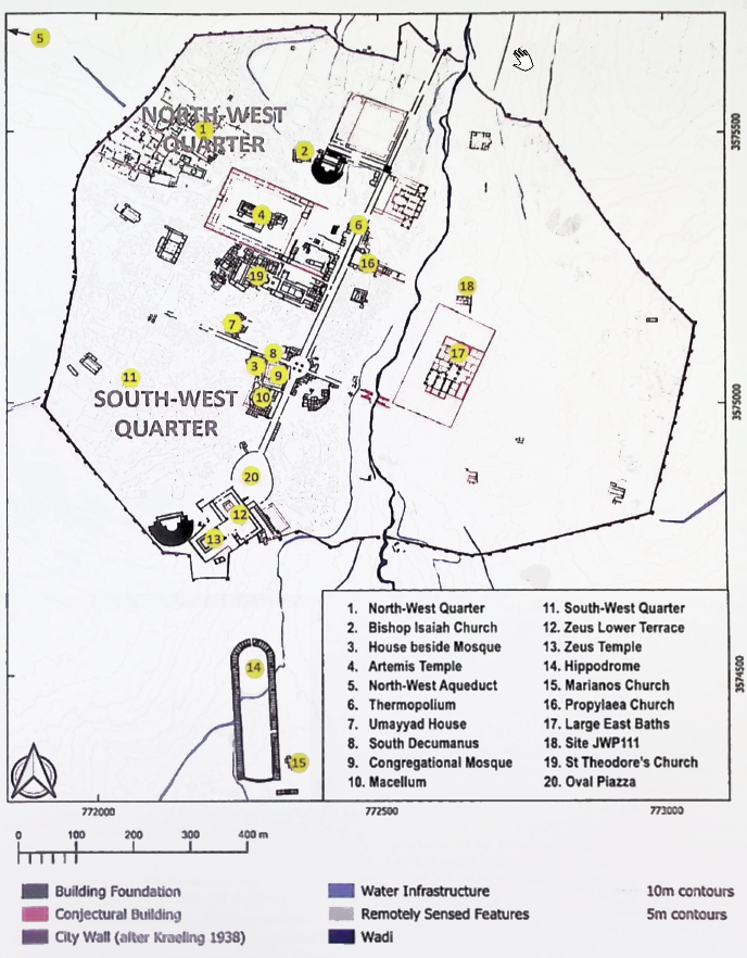 Figure 2.6
Plan of ancient Gerasa showing the location of earthquake-damaged sites referred to in Table 2.2
(after Lichtenberger, Raja, and Stott 2019.fig.2)
Click on Image to open in a new tab
Lichtenberger and Raja (2025)
- from Lichtenberger and Raja (2025)
- Fig. 2.6 Map of seismic damage
in Jerash between the 1st and 19th centuries CE from Lichtenberger and Raja (2025)
Figure 2.6
Plan of ancient Geras showing the location of earthquake-damaged sites referred to in Table 2.2
(after Lichtenberger, Raja, and Stott 2019.fig.2)
Click on Image to open in a new tab
Lichtenberger and Raja (2025)
Table 2.2List of seismically induced damage recorded in Gerasa where the relaibility of the evidence is considered to be medium or high
Click on Image to open in a new tab
Lichtenberger and Raja (2025)