Horbat Hazaza
 Horbat Hazaza
click on image to explore this site on a new tab in govmap.gov.il
- Fig. 1 Location Map from
from Erickson-Gini (2019)
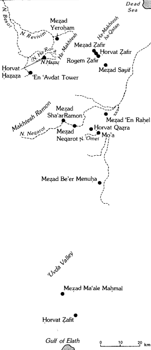
 Fig. 1
Location map of the site and its surroundings
(©2019 all rights reserved by the Survey of Israel, printed with Survey of Israel permission)
Erickson-Gini (2019) - Location Map from
Stern et. al. (1993 v.3)
 Map of the main Hellenistic, Roman, and Byzantine sites in the Negev Hills
Stern et. al. (1993 v.3)
- Fig. 1 Location Map from
from Erickson-Gini (2019)
Fig. 1
Location map of the site and its surroundings
(©2019 all rights reserved by the Survey of Israel, printed with Survey of Israel permission)
Erickson-Gini (2019) - Location Map from
Stern et. al. (1993 v.3)
Map of the main Hellenistic, Roman, and Byzantine sites in the Negev Hills
Stern et. al. (1993 v.3)
- Horbat Hazaza in Google Earth
 Horbat Hazaza
click on image to explore this site on a new tab in Google Earth - Horbat Hazaza on govmap.gov.il
Horbat Hazaza
click on image to explore this site on a new tab in govmap.gov.il
- Site Plan & Section
from Erickson-Gini (2019)
 Plan 1
Site Plan and Section
Erickson-Gini (2019)
- Site Plan & Section
from Erickson-Gini (2019)
Plan 1
Site Plan and Section
Erickson-Gini (2019)
- Site Plan & Section
from Erickson-Gini (2019)
Plan 1
Site Plan and Section
Erickson-Gini (2019)
- Site Plan & Section
from Erickson-Gini (2019)
Plan 1
Site Plan and Section
Erickson-Gini (2019)
| Effect | Location | Image(s) | Description |
|---|---|---|---|
| Destruction | south wing
Plan 1 Site Plan and Section Erickson-Gini (2019) |
|
|
| collapsed arches | Room 2
Plan 1 Site Plan and Section Erickson-Gini (2019) |
|
- Modified by JW from Plan 1 of Erickson-Gini (2019)
 Deformation Map
Modified by JW from Plan 1 of Erickson-Gini (2019)
-
Earthquake Archeological Effects chart
of Rodríguez-Pascua et al (2013: 221-224)
 Earthquake Archeological Effects (EAE)
Rodríguez-Pascua et al (2013: 221-224)
| Effect | Location | Image(s) | Description | Intensity |
|---|---|---|---|---|
| Destruction - collapsed walls ? | south wing
Plan 1 Site Plan and Section Erickson-Gini (2019) |
|
VIII+ ? | |
| collapsed arches | Room 2
Plan 1 Site Plan and Section Erickson-Gini (2019) |
|
VI + |