Horbat Dafit
| Transliterated Name | Source | Name |
|---|---|---|
| Horbat Dafit | Hebrew | הורבט דפיט |
| Horvat Dafit | Hebrew | הורבט דפיט |
| Horbat `Avrona | ||
| Khirbat ad Dafiya | Arabic |
- Location Map from
Stern et. al. (1993 v.3)
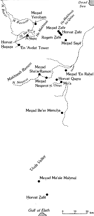 Map of the main Hellenistic, Roman, and Byzantine sites in the Negev Hills
Stern et. al. (1993 v.3) - Location Map from
Dolinka (2006)
 Fig. 4.1
Map showing the location of Horvat Dafit, Petra, Aila and the principal sites situated along the Nabataean route on the western escarpment of the Wadi Arabah valley
(by B. Dolinka)
Dolinka (2006)
- Location Map from
Stern et. al. (1993 v.3)
Map of the main Hellenistic, Roman, and Byzantine sites in the Negev Hills
Stern et. al. (1993 v.3) - Location Map from
Dolinka (2006)
Fig. 4.1
Map showing the location of Horvat Dafit, Petra, Aila and the principal sites situated along the Nabataean route on the western escarpment of the Wadi Arabah valley
(by B. Dolinka)
Dolinka (2006)
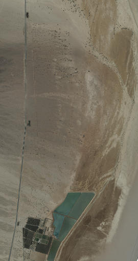
- Vicinity of Horbat Dafit in Google Earth
 Vicinity of Horbat Dafit
click on image to explore this site on a new tab in Google Earth - Vicinity of Horbat Dafit on govmap.gov.il
 Vicinity of Horbat Dafit
click on image to explore this site on a new tab in govmap.gov.il
- Plan of Phase 1 structure
from Dolinka (2006)
 Fig. 4.4
Plan of the Phase I structure at Horvat Dafit (courtesy IAA Archives, Rockefeller Museum).
Dolinka (2006) - Plan of Phase 2 structure
from Dolinka (2006)
 Fig. 4.10
Top Plan of the Nabataean caravanserai at Horvat Dafit in Phase 2, 2nd century AD (courtesy IAA Archives, Rockefeller Museum).
Dolinka (2006) - Plan of Phase 3 structure
from Dolinka (2006)
 Fig. 4.24
Plan of the Phase 3 structure at Horvat Dafit (courtesy IAA Archives, Rockefeller Museum).
Dolinka (2006)
- Plan of Phase 1 structure
from Dolinka (2006)
Fig. 4.4
Plan of the Phase I structure at Horvat Dafit (courtesy IAA Archives, Rockefeller Museum).
Dolinka (2006) - Plan of Phase 2 structure
from Dolinka (2006)
Fig. 4.10
Top Plan of the Nabataean caravanserai at Horvat Dafit in Phase 2, 2nd century AD (courtesy IAA Archives, Rockefeller Museum).
Dolinka (2006) - Plan of Phase 3 structure
from Dolinka (2006)
Fig. 4.24
Plan of the Phase 3 structure at Horvat Dafit (courtesy IAA Archives, Rockefeller Museum).
Dolinka (2006)
- Revised chronology from Dolinka (2006)
- Chronology is based on ceramics and/or numismatics
- Dating Matrix of the structure at
Horvat Dafit from Dolinka (2006)
 Fig. 4.38
Matrix of the structure at Horvat Dafit, detailing the three loci (i.e. phases) for each room.
Dolinka (2006)
| Phase | Date | Comments |
|---|---|---|
| 3 | late 2nd- early 3rd centuries CE |
|
| 2 | 2nd-3rd centuries CE |
|
| 1 | 1st century CE |
|
- Plan of Phase 1 structure
from Dolinka (2006)
Fig. 4.4
Plan of the Phase I structure at Horvat Dafit (courtesy IAA Archives, Rockefeller Museum).
Dolinka (2006) - Plan of Phase 2 structure
from Dolinka (2006)
Fig. 4.10
Top Plan of the Nabataean caravanserai at Horvat Dafit in Phase 2, 2nd century AD (courtesy IAA Archives, Rockefeller Museum).
Dolinka (2006) - Plan of Phase 3 structure
from Dolinka (2006)
Fig. 4.24
Plan of the Phase 3 structure at Horvat Dafit (courtesy IAA Archives, Rockefeller Museum).
Dolinka (2006)
| Effect | Location | Image(s) | Description |
|---|---|---|---|
| collapse of architectural elements | several of the rooms
Fig. 4.4 Plan of the Phase I structure at Horvat Dafit (courtesy IAA Archives, Rockefeller Museum). Dolinka (2006) |
several of the rooms within the structure exhibited collapse of the architectural elements as well as ashy layers associated with that event.- Dolinka (2006:130) |
|
| mudbrick collapse building debris Cleaning of the interior repairs and reconstruction |
Loci 46, 23, 26, 27, 45, and 50
Fig. 4.4 Plan of the Phase I structure at Horvat Dafit (courtesy IAA Archives, Rockefeller Museum). Dolinka (2006) |
the earliest levels of [phase 2] are characterized by mudbrick collapse and/or building debris (e.g. Locus 46), cleaning of the interior of some of the rooms (e.g. Loci 23. 26 and 50), repair to damaged walls (e.g. Locus 45), and reconstruction of the main entrance and gate (Locus 27).- Dolinka (2006:135-136) |
-
Earthquake Archeological Effects chart
of Rodríguez-Pascua et al (2013: 221-224)
 Earthquake Archeological Effects (EAE)
Rodríguez-Pascua et al (2013: 221-224)
| Effect | Location | Image(s) | Description | Intensity |
|---|---|---|---|---|
| collapse of architectural elements - collapsed walls | several of the rooms
Fig. 4.4 Plan of the Phase I structure at Horvat Dafit (courtesy IAA Archives, Rockefeller Museum). Dolinka (2006) |
several of the rooms within the structure exhibited collapse of the architectural elements as well as ashy layers associated with that event.- Dolinka (2006:130) |
VIII+ | |
| mudbrick collapse building debris Cleaning of the interior repairs and reconstruction |
Loci 46, 23, 26, 27, 45, and 50
Fig. 4.4 Plan of the Phase I structure at Horvat Dafit (courtesy IAA Archives, Rockefeller Museum). Dolinka (2006) |
the earliest levels of [phase 2] are characterized by mudbrick collapse and/or building debris (e.g. Locus 46), cleaning of the interior of some of the rooms (e.g. Loci 23. 26 and 50), repair to damaged walls (e.g. Locus 45), and reconstruction of the main entrance and gate (Locus 27).- Dolinka (2006:135-136) |
VIII+ |