Herodium
 Aerial View of Herodium
Click on Image to open a higher resolution magnifiable image in a new tab
Asaf T. - Wikipedia - Public Domain
| Transliterated Name | Language | Name |
|---|---|---|
| Herodium | Latin | |
| Herodeion | Greek | Ἡρώδειον |
| Herodium | Hebrew | הרודיון |
| Har Hordus | Hebrew | |
| Herodis | Hebrew | הרודיון |
| Herodium | Name in documents from the time of Bar-Kokhba | |
| Jabal al-Fureidis | Arabic | جبل فريديس |
| Herodion | alternate spelling | |
| Frank Mountain | ||
| Mountain of Little Paradise | ||
| Bethulia |
- Annotated Aerial View of Herodium
from biblewalks.com
 Annotated Aerial View of Herodium
Google and biblewalks.com - Herodium in Google Earth
 Herodium
click on image to explore this site on a new tab in Google Earth - Herodium on govmap.gov.il
 Herodium
click on image to explore this site on a new tab in govmap.gov.il
- from Netzer (2008)
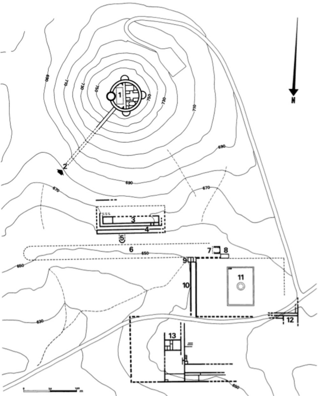 Ill. 85
General plan of Greater Herodium:
- The mountain palace-fortress
- The main stairway to the mountain
- The large palace (building A101)
- The large palace's substructural halls
- A tentative balcony adjacent to the large palace
- The course
- The monumental building
- Building B14
- A rectangular structure—the south-eastern corner of the pool complex
- A damlike wall with galleries on top
- The pool complex, with the pool in its center
- The service building
- The northern wing
Netzer (2008)
- Ill. 85 General plan of
greater Herodium from Netzer (2008)
Ill. 85
General plan of Greater Herodium:
- The mountain palace-fortress
- The main stairway to the mountain
- The large palace (building A101)
- The large palace's substructural halls
- A tentative balcony adjacent to the large palace
- The course
- The monumental building
- Building B14
- A rectangular structure—the south-eastern corner of the pool complex
- A damlike wall with galleries on top
- The pool complex, with the pool in its center
- The service building
- The northern wing
Netzer (2008) - General plan of the site
from Stern et al (1993)
 Herodium: general plan of the site.
Stern et al (1993)
- Ill. 85 General plan of
greater Herodium from Netzer (2008)
Ill. 85
General plan of Greater Herodium:
- The mountain palace-fortress
- The main stairway to the mountain
- The large palace (building A101)
- The large palace's substructural halls
- A tentative balcony adjacent to the large palace
- The course
- The monumental building
- Building B14
- A rectangular structure—the south-eastern corner of the pool complex
- A damlike wall with galleries on top
- The pool complex, with the pool in its center
- The service building
- The northern wing
Netzer (2008) - General plan of the site
from Stern et al (1993)
Herodium: general plan of the site.
Stern et al (1993)
- Ill. 9 General plan of
the pool complex of lower Herodium from Netzer (2008)
 Ill. 9
General plan of the pool complex
Netzer (2008)
- Ill. 9 General plan of
the pool complex of lower Herodium from Netzer (2008)
Ill. 9
General plan of the pool complex
Netzer (2008)
- Ill. 36 Plan of the
service building in the the pool complex of lower Herodium from Netzer (2008)
 Ill. 36
Plan of the service building
Netzer (2008)
- Ill. 36 Plan of the
service building in the the pool complex of lower Herodium from Netzer (2008)
Ill. 36
Plan of the service building
Netzer (2008)
- Reconstruction of the site
around 15 BCE from Langgut (2022)
 Figure 4
Reconstruction of the mausoleum garden during its early period, around 15 BCE
drawing by Y. Korman
Langgut (2022)
- Reconstruction of the site
around 15 BCE from Langgut (2022)
Figure 4
Reconstruction of the mausoleum garden during its early period, around 15 BCE
drawing by Y. Korman
Langgut (2022)
- Ill. 8 General view of
the pool complex of lower Herodium from Netzer (2008)
 Ill. 8
General view of the pool complex (at end of 1972 season).
Netzer (2008) - Ill. 28 Door sill and
fallen jamb in the pool complex of lower Herodium from Netzer (2008)
 Ill. 28
Door sill and fallen jamb east of wall W159 (in sounding B11), looking east
Netzer (2008) - Ill. 37 Storage hall, B20,
showing its collapsed barrel-vaulted ceiling in the pool complex of lower Herodium from Netzer (2008)
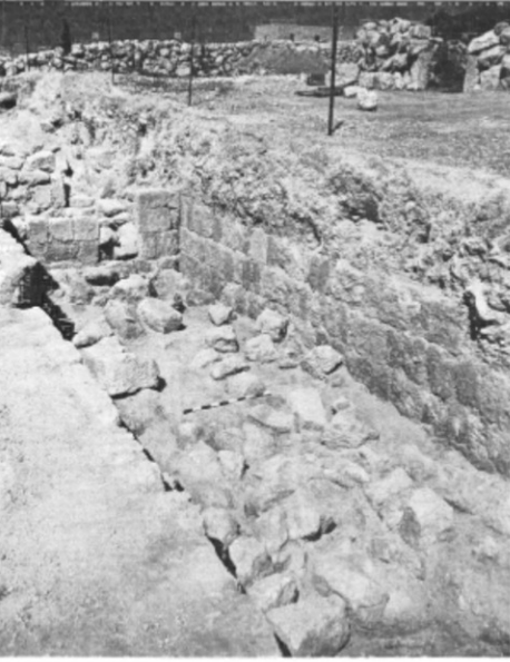 Ill. 37
Storage hall, B20, showing its collapsed barrel-vaulted ceiling, looking north-west. In the background can be seen the later wall (W101).
Netzer (2008) - Ill. 38 Rooms B56, B57, and
B20 in the pool complex of lower Herodium from Netzer (2008)
 Ill. 38
Rooms B56, B57, and B20 (in the background), looking east. A section of room B55 can be seen in the foreground.
Netzer (2008) - Ill. 39 restored storage
jars which were found on the floor of the early storage hall in the pool complex of lower Herodium from Netzer (2008)
 Ill. 39
Group of restored storage jars which were found on the floor of the early storage hall.
Netzer (2008) - Ill. 42 Hall B41 with debris
from Netzer (2008)
 Ill. 42
Hall B41, facing south, with wall W34 on the right, in an carly stage of the excavations (1972). Note the heavy debris of building stones.
Netzer (2008) - Ill. 43 collapsed arches
of hall B41 in the pool complex of lower Herodium from Netzer (2008)
 Ill. 43
Two collapsed arches fallen from wall W35 (of hall B41). looking east.
Netzer (2008)
- Ill. 8 General view of
the pool complex of lower Herodium from Netzer (2008)
Ill. 8
General view of the pool complex (at end of 1972 season).
Netzer (2008) - Ill. 28 Door sill and
fallen jamb in the pool complex of lower Herodium from Netzer (2008)
Ill. 28
Door sill and fallen jamb east of wall W159 (in sounding B11), looking east
Netzer (2008) - Ill. 37 Storage hall, B20,
showing its collapsed barrel-vaulted ceiling in the pool complex of lower Herodium from Netzer (2008)
Ill. 37
Storage hall, B20, showing its collapsed barrel-vaulted ceiling, looking north-west. In the background can be seen the later wall (W101).
Netzer (2008) - Ill. 38 Rooms B56, B57, and
B20 in the pool complex of lower Herodium from Netzer (2008)
Ill. 38
Rooms B56, B57, and B20 (in the background), looking east. A section of room B55 can be seen in the foreground.
Netzer (2008) - Ill. 39 restored storage
jars which were found on the floor of the early storage hall in the pool complex of lower Herodium from Netzer (2008)
Ill. 39
Group of restored storage jars which were found on the floor of the early storage hall.
Netzer (2008) - Ill. 42 Hall B41 with debris
from Netzer (2008)
Ill. 42
Hall B41, facing south, with wall W34 on the right, in an carly stage of the excavations (1972). Note the heavy debris of building stones.
Netzer (2008) - Ill. 43 collapsed arches
of hall B41 in the pool complex of lower Herodium from Netzer (2008)
Ill. 43
Two collapsed arches fallen from wall W35 (of hall B41). looking east.
Netzer (2008)
| Effect | Location | Image(s) | Description |
|---|---|---|---|
|
The storage hall in Lower Herodium
Ill. 85 General plan of Greater Herodium:
Netzer (2008)
General plan of the pool complexNetzer (2008) |
Ill. 37 Storage hall, B20, showing its collapsed barrel-vaulted ceiling, looking north-west. In the background can be seen the later wall (W101). Netzer (2008)
Ill. 39Group of restored storage jars which were found on the floor of the early storage hall. Netzer (2008) |
|
|
Hall B41 in Lower Herodium
Ill. 85 General plan of Greater Herodium:
Netzer (2008)
General plan of the pool complexNetzer (2008) |
Ill. 43 Two collapsed arches fallen from wall W35 (of hall B41). looking east. Netzer (2008)
Ill. 42Hall B41, facing south, with wall W34 on the right, in an carly stage of the excavations (1972). Note the heavy debris of building stones. Netzer (2008) |
|
-
Earthquake Archeological Effects chart
of Rodríguez-Pascua et al (2013: 221-224)
 Earthquake Archeological Effects (EAE)
Rodríguez-Pascua et al (2013: 221-224)
| Effect | Location | Image(s) | Description | Intensity |
|---|---|---|---|---|
|
The storage hall in Lower Herodium
Ill. 85 General plan of Greater Herodium:
Netzer (2008)
General plan of the pool complexNetzer (2008) |
Ill. 37 Storage hall, B20, showing its collapsed barrel-vaulted ceiling, looking north-west. In the background can be seen the later wall (W101). Netzer (2008)
Ill. 39Group of restored storage jars which were found on the floor of the early storage hall. Netzer (2008) |
|
|
|
Hall B41 in Lower Herodium
Ill. 85 General plan of Greater Herodium:
Netzer (2008)
General plan of the pool complexNetzer (2008) |
Ill. 43 Two collapsed arches fallen from wall W35 (of hall B41). looking east. Netzer (2008)
Ill. 42Hall B41, facing south, with wall W34 on the right, in an carly stage of the excavations (1972). Note the heavy debris of building stones. Netzer (2008) |
|
|